This is interesting. It appears that a “pause” has developed in global sea levels. For two years, since July 2015, there has been no sustained increase in global sea level, in fact, it appears to have actually fallen a bit. This graph, provided by NASA’s Global Climate Change website, tells the story:

A zoom of the area of interest, two years prior to the most recent data point.

Source for both graphs: https://climate.nasa.gov/vital-signs/sea-level/
The satellite derived sea level data is also available here: ftp://podaac.jpl.nasa.gov/allData/merged_alt/L2/TP_J1_OSTM/global_mean_sea_level/GMSL_TPJAOS_V4_199209_201708.txt
NASA says on that website:
Sea level rise is caused primarily by two factors related to global warming: the added water from melting ice sheets and glaciers and the expansion of sea water as it warms. The first graph tracks the change in sea level since 1993 as observed by satellites.
Hmmm, I think they left something out of that description.
The other source for sea level data, at the University of Colorado, also shows a pause, though they have not yet updated their data for 2017:

What I found most interesting on the UC sea level page was this graph, showing the correlation of El Niño Southern Oscillation (ENSO) and global sea level. [Readers] may recall that in 2015, there was a massive spike of an El Niño event:

The correlation between ENSO and sea level seems strong.
Note this image from a NASA Visualization Video, which shows water piling up in the Western Pacific over the past 22 years. Wind pattern shifts are a signature of ENSO events, and they push water westward where it piles up.

Here is another projection of the same data, showing that water has been piling up in the Western Pacific:

I wonder what the rate of sea level rise would look like is we masked out El Nino events? I’m guessing it would be far, far, less than what is being claimed as “global”.
ENSO 3.4 sudden drop to -0.38 today. Another winner fact. That’s 4 great posts to read today and I have not even got to the good news EPA article.
Wow.
And Gore said “NASA – never heard of them – are they deniers?”
So San Francisco us sueing Exxon for supposed SLR? Those NASA graphs are rather inconvenient for the City’s case don’t you think? But then again so we’re their tide gauge data even before they claimed they would bring the suit.
Rah, let’s see. CAGW is evidenced by:
1) Accelerating SLR. Not.
2) Tropical Tropospheric Hot Spot. Not.
3) Increasing severe weather, floods, droughts, hurricanes, tornadoes, etc. Not.
4) Atmosphere warms the surface under increasing CO2. Not.
5) Antarctic ice melting. Not.
6) Arctic sea ice death spiral. Not.
7) Climate models accurately reflect/predict global warming, precipitation, etc. Not.
8) [Add your own.]
Where is all this consensus science?
I’d love to see all the comments on the draft IPCC AR6. Although I do believe AR6 will have the same bureaucratic gobbly gook and misdirection as had AR5. Entire sections contradicted others. And I predict the bureaucrats/politicians will be even more sure of their “science” in the AR6 SPM.
CAGW is very real for 97% of carefully selected climate scientists. Unfortunately, Mother Nature is not a part of this selection.
Bumper sticker:
Climate Change
Is 97% Bull Shit
+100%
Mr. Layman here.
Sea level rise. If I I understand it correctly, it is an attempt to measure the top layer of the oceans against the bottom layer of the land.
It is not a measure of the volume of water in the oceans.
The land level and “the bowl” that holds the oceans changes (plate tectonics and all that).
So just how does a rise in “sea level rise” have much of anything to do with CAGW?
Notwithstanding the forgoing, we are all going to die! Have as much sex as possible now, at your discretion.
Like Harvey and both Bills, JB?
You know, this is something that has bugged me.
People take sea level rise as if it is evidence of global warming, and a lack of sea level rise as evidence against it. But it is a secondary prediction, based on the prediction of warming. You can spin up an alternative scenario where warming causes sea level to drop.
What cases sea level rise? Thermal expansion of the ocean for one. And global warming would cause this to increase. The other is sequestration of water as ice on land.
Now, there are two great reservoirs of land fast ice – Greenland and Antarctica. Everything else is a round error.
Cold air hold less moisture. The north slope of Alaska for example is often referred to as an Arctic desert – it receives around 4 inches of precip. a year. The Brooks Range has very few glaciers not because it is too hot, but because it is too cold. This precip. is about the same as the Sahara desert (look it up). Antarctica gets around six inches, but very little in the interior.
So, if the air warmed slightly in Antarctica, it would hold a lot more moisture. And that moisture would accumulate as ice. By this mechanism, a lot of water could be extracted and sequestered from the oceans. Therefore warming might cause more water to be sequestered, directly counteracting any thermal expansion. Sea level could even fall in a global warming scenario, at least you could make some sort of case that is possible.
Which again – the global warming enthusiasts seem to think this is all so simple – warmer = sea level rise. But again, reality is messy. None of that may actually happen the way they imagine.
…the way they imagine
Bingo!
Isn’t it 99.06% BS
Sea Level Rise (SLR) has been stuck at 6~7 inches per CENTURY since the 19th century, and the 21st will be about the same.
CAGW’s various doom and gloom SLR predictions of 3 feet to 50 feet by 2100 have always been absurd, but they were very effective for brainwashing propaganda purposes.
NASA’s SLR graphs showing satellite and tide gauge data are comical:
1) It only shows tide-gauge data from 1870 to 2000 and completely leaves off the last 17 years.
2) it conveniently leaves off the tide-gauge trend rate of 1.5mm/year, but prominently displays the satellite SLR rate at 3.4mm/yr… Hmmm… a convenient oversight..
https://climate.nasa.gov/vital-signs/sea-level/
With the AMO 30-yr cool cycle soon starting, combined with the approaching Grand Solar Minimum event, SLR rates will likely continue to slow and may even show a falling trend by the end of this century..
“Houston, we don’t have a problem…”
I think a look at Sst map from NOAA shows very cold ocean, particularly the southern hemisphere.
http://www.ospo.noaa.gov/data/sst/anomaly/2017/anomnight.10.16.2017.gif
This is what is effecting sea level decline. Even the hype about terminal bleaching of the GBR was actually due to exposure of coral into the atmosphere and surrounding water being very shallow. Ice extent is also recovering at both poles. This NH winter will also be a doozie. The La Nina cometh.
http://www.bom.gov.au/climate/enso/monitoring/nino3_4.png
Click the bottom graph to get the update
According to NASA: “From its vantage point 1336 kilometers (830 miles) above the Earth, the US/European Jason-1 and OSTM/Jason-2 ocean altimeter satellites measure the height of the ocean surface directly underneath the satellite with an accuracy of 4-5 centimeters (better than 2 inches). Traveling in excess of 7 kilometers (4 miles) every second as they trace out an orbit, the spacecraft cover the global oceans every 10 days (the “repeat period” of the satellite orbit).
This accuracy figure pertains to a few-kilometer spot on the ocean surface directly beneath the satellite. By averaging the few-hundred thousand measurements collected by the satellite in the time it takes to cover the global oceans (10 days), global mean sea level can be determined with a precision of several millimeters.”
https://sealevel.jpl.nasa.gov/technology/
NOAA uses 199 tide gauge records covering the past century to arrive at an average sea level increase of 1.08 mm per year, which is far less than the “precision of several millimeters” that NASA determines from satellite observations – derived from averaging hundreds of thousands of satellite measurements, each of which has an accuracy of 40 to 50 millimeters (possibly double, if the observation = n +/- 50 mm). In certain instances of repeated observations with the same device of the same spot, averaging hundreds of thousands of observations may reduce error, but not when each observation is of a different point and speed over ten days.
NASA claims satellite measured sea level rise is 3.2 mm/year, triple the tide gauges, but still only a modest 13 inches per century. San Francisco Bay Area alarmists predict sea level rise of five feet or more by 2100. Sea level fell almost four inches 1983 to 2016. To reach five feet by 2100 the rate of rise will have to increase by 17 times tomorrow and be sustained for 84 years.
Even if the NASA rate of 3.2 mm/year was correct, and tide gauge measurements show it is not, the rate would have to increase five times for the 84-year period. Each year that passes without at least a 17 mm rise in sea level just adds that much more needed to later year rates. After 2050 the rate would have to be over an inch per year, a rate not seen since mile-thick ice sheets retreated from Canada 18,000 to 12,000 years ago.
Science fiction masquerades as science fact, and skeptics are called anti-science because they reject the fantasies.
We should start referring to the Alarmists as Noah.
Fake news from NASA and USA.
Why are You not showing the sea level trends measurements that has a long record any more.
Ground data is missing after year 2000. Why?
Many persons believe in NASA and those graphs.
You have a responsibility as leading nation!
Get rid of those fake news please!
Obama’s first success. And tomorrow, I will cause the sun to rise in the East. Wait and see.
Sea level rise is enigmatic. The curve plotted by Jo Nova based on data in Jevreja et al (2008) shows sea level going up and down from 1700 to 1850 but no long-term increase. Then in 1850, sea level sets out on a linear, long term rise that continues today. The overall rate for 250 years is about 7 inches per century, in contrast to the satellite data which is twice that amount. The curious thing about the curve is the suddenness of the change in 1850 and the long, linear rise thru three warm periods and three cool periods with virtually no change in the rate. Apparently, warming and cooling doesn’t affect sea level very much. What I get out of all this is that we really don’t understand sea level rise very well.
But speculation runs rampant in the climate “science” community, Don. Tipping points must be assumed because extreme predictions are laughable when compared to current trends. Crickets are all you hear when alarmists are told SLR would have to instantly jump to 17 mm/yr to meet their low-end 2100 guesses.
If this keeps up, you can bet dollars to doughnuts that select “team” members will find some reason to explain it away (my guess is volcano cooling). If this doesn’t “fit the bill” then look to data adjustments. Might even see a few new “science papers” that explain why.
What I doubt we will see is an actual acknowledgment of it by “the cause” “team” members.
Anthony notes a pause in sea level rise which could well be could well important.

The methods used by the establishment climate science community are not fit for purpose. A new forecasting paradigm should be adopted. Earth’s climate is the result of resonances and beats between various quasi-cyclic processes of varying wavelengths. It is not possible to forecast the future unless we have a good understanding of where the earth is in time in relation to the current phases of those different interacting natural quasi periodicities. Evidence is presented in my 2017 Energy and Environment paper. (see blog version at
http://climatesense-norpag.blogspot.com/2017/02/the-coming-cooling-usefully-accurate_17.html )
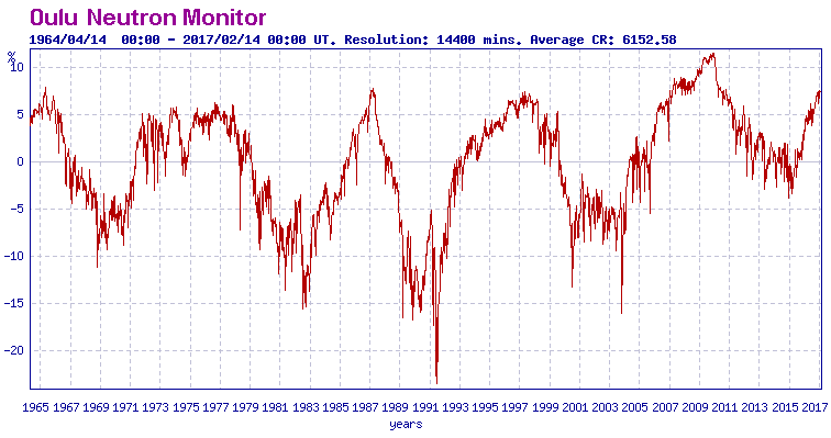
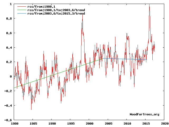
This paper specifies the timing and amplitude of the natural 60+/- year and, more importantly, 1,000 year periodicities (observed emergent behaviors) that are so obvious in the temperature record. Data related to the solar climate driver is discussed and the solar cycle 22 low in the neutron count (high solar activity) in 1991 is identified as a solar activity millennial peak and correlated with the millennial peak and inversion point – in the RSS temperature trend in about 2003. The cyclic trends are projected forward and predict a probable general temperature decline in the coming decades and centuries. (Fig 12)
Because of the thermal inertia of the oceans there is a varying lag between the solar activity peak and the corresponding peak or low in the different climate metrics.
1.There is a 13+/- year delay between the solar activity “Golden Spike” 1991 peak in Fig 10 and the millennial cyclic “Golden Spike” temperature peak seen in the RSS data in Fig 3. It has been independently estimated that there is about a 12-year lag between the cosmic ray flux and the temperature data – Fig. 3 in Usoskin .https://www.researchgate.net/publication/41624745_Solar_activity_over_the_last_1150_years
Fig 10
Fig4
The RSS cooling trend in Fig. 4 was truncated at 2015.3 because it makes no sense to start or end the analysis of a time series in the middle of major ENSO events which create ephemeral deviations from the longer term trends. By the end of August 2017, the strong El Nino temperature anomaly had declined substantially . The cooling trend is likely to be fully restored by the end of 2019.
2. There is 21 year delay between the solar activity peak and the Arctic sea ice volume and Arctic sea ice area low in 2012.
3.It is certainly possible that Anthony’s pause in sea level rise seen above marks the same 1991 solar activity peak with a delay of 24/25+/- years and could mark the beginning of a long term decline.
4. This same 1991 solar activity peak shows up in the early 21st century change in temperature and cloud cover trends in Fig 11.
The evidence that we have just passed the millennial temperature peak and that a long term cooling is underway continues to mount.
When and why is NASA involved in climate stuff anyway? NASA…North >American “Space” Administration. Isn’t that the bit “above” the atmosphere? ….. oh yes of course… how silly of me, follow the money now there is no shuttle to justify ( a lot of ) their existence and by gosh is there a lot of gravy for agencies jumping on the GW/CC/(or whatever they will change that to when it does not do what they want anymore) band wagon?
” Isn’t that the bit “above” the atmosphere?” ….. No, your problem is that you don’t know what NASA stands for. It’s the National Aeronautics and Space Administration. I suggest you look up “Aeronautics” then get back to us.
Any pause in sea level rise is likely due to rotten water, which masks continued rise caused by CO2 global warming. Still looking for the link to that research.
There’s no sound basis for assuming that close wiggle-watching provides useful insight into secular global sea-level changes.