Supposed threats to coastal military installations ignore science
By Bob Endlich
“Data from CO2 measuring stations and from the Sewell’s Point and all other tide gages may clearly refute these assertions, but NPR and its colleagues will not change their minds.”
“The Sewell’s Point tide gage shows that the rate of sea level rise has not changed since the gage was installed in 1927, and is unchanged from our use of fossil fuels. It’s time to base our policies on sound science, instead of manmade global warming fiction and scare stories.”
National Public Radio’s March 31 “Morning Edition” program carried a “news” story claiming that rising seas threaten a number of U.S. coastal military bases. The commentary was so laden with factual errors that listeners might have thought it was an early April fool’s joke. Unfortunately, it was not.
NPR remains so wedded to its belief that humans and carbon dioxide emissions are causing a fossil fuels–driven global warming catastrophe that its reporting has been compromised, and it is unable to think critically or report honestly without resorting to activist claims and fake news events.
Real journalism would have at least included passing references to alternative views and sources. But they were absent in this story, which in truth is a splendid example of ignorance or deception—reader’s choice.
Host David Greene introduced the sea level segment, noting that President Trump is taking steps to reverse Obama-era policies that called [manmade CO2-driven] climate change a national security threat. Reporter Jay Price then expanded on the national security theme, claiming the Sewell’s Point tide gage (or gauge) at the Norfolk, Virginia Naval Station shows that seas are rising there at the highest rates on the East Coast.
His errors began right from the outset. Sea level rise measured at Sewell’s Point is 4.59 millimeters (0.18 inches) per year. That’s less than recorded by neighboring Virginia tide gages: the Chesapeake Bay Bridge Tunnel gage measured an average sea level rise of 5.93 mm annually; up the Delmarva Peninsula, on Virginia’s Eastern Shore, Wachapreague gage records show average seal level rise of 5.37 mm/year.
Tide Gages Only Part of the Story
In principle, a tide gage is like the float in a toilet tank. As water flows in, the gage shows a rise; as water flows out, it records a fall. However, tide gages are unable to determine whether changing water levels over time are due to changing sea levels, or whether the land on which it sits is rising or falling. That needs to be determined by another measure. Using GPS data from many years is a good method to determine the long term vertical motion of the ground near the tide gage.
Tide gage data are readily available at NOAA’s “Tides and Currents” web site. But Dave Burton’s Sea Level Info website has added carbon dioxide concentrations to the tide gage height, correlating the two topics. His site shows clearly and directly that CO2 concentrations have had no effect on rates of sea level rise. The Sewell’s Point sea level and CO2 plot is shown in Figure 1 below.

Figure 1. Sea Level Rise at Sewell’s Point
http://www.sealevel.info/MSL_graph1.php?id=8638610
The rate of sea level has fluctuated several times over multi-decadal periods, but there is no human-caused CO2-fueled global warming signal in the data. Indeed, the rate of rise has not changed since 1927. In other words, there is no acceleration in sea level rise.
However, the Greene and Price’s reporting make it clear that, as they and NPR see it, sea level rise is definitely human-caused, the result of our using fossil fuels. In essence, this has morphed into a looming dual disaster: a national security threat and a dangerous manmade climate change threat. Their viewpoint is clearly political, unsupported by objective scientific data.
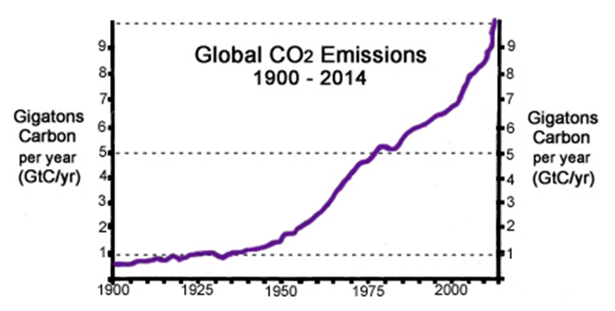
Figure 2 presents the best available estimate of global carbon dioxide emissions from 1900 to 2014. As it demonstrates, when the Sewell’s Point tide gage was installed in 1927, the global rate of CO2 emissions was about 1 GT/year. The most recent available estimate of CO2 emissions (2014) was about 10 GT/year. Comparing this CO2 data with the Sewell’s Point tide gage record in Figure 1 makes it clear that the rate of sea level rise at Sewell’s Point is unchanged over this nine-decade period.

Figure 2. Carbon dioxide emissions over time.
http://notrickszone.com/wp-content/uploads/2016/11/CO2-Emissions-1900-2014-GtC-per-year-ps-.jpg
In summary, there is no human-caused CO2-fueled global warming signature in the tide gage record at Sewell’s Point – or anywhere else in the tide gage records, including the Battery in New York City and in San Francisco, where tide gage records go back to the time of the U.S. Civil War.
NPR’s Unreliable “Experts”
But this does not prevent NPR from quoting Retired Rear Admiral David Titley, then of the climate-obsessed Obama Administration and now of Penn State University, who declared that the sea level rise at Norfolk is definitely a result of human-caused climate change. (As many before me have pointed out, the U.S. military is and has always been under the direction and control of a civilian president.)
Nor do scientific facts prevent NPR from using this recent story from the always alarmist Union of Concerned Scientists and this flawed methodology from another “global warming is manmade” group, claiming that human-caused global warming has raised sea level “about eight inches since 1880, and the rate of rise is accelerating.” Data from CO2 measuring stations and from the Sewell’s Point and all other tide gages may clearly refute these assertions, but NPR and its colleagues will not change their minds.
Sea Level Rise and Land Subsidence
It is easy to see why this report and this reporting are in error. The majority by far of the apparent sea level rise in the Norfolk-Hampton-Newport News area is caused by two important non-climate-related forces: subsidence associated with an ancient subterranean impact crater, and the compaction of former wetlands filled in for development.
The center of the huge Chesapeake Bay Impact Crater is near the southern tip of the Delmarva Peninsula, and its proximity to Sewell’s Point is graphically shown here. The crater’s structure below the Hampton Roads region is causing most of the present-day subsidence of the terrain in this area.
Examining a satellite-based map of the Norfolk area reveals nearly straight shorelines, right angled corners, piers and other indications that show the terrain has been modified by dredging and filling of former wetlands to suit the needs of developers. When marshes are dredged and filled, the once muddy, wet fill continues to compact for decades, resulting in slow terrain subsidence, just as this article from The Economist reports: “In America, groundwater extraction without commensurate recharge [of water in the subsurface formations] is responsible for 80% of subsidence.”
In short, no matter how much NPR’s reporter and sources claim sea level rise is human-caused and CO2-fueled, the tide gage data show no correlation between rates of sea-level rise and human production of carbon dioxide. Clearly, the gradual inundation of these coastal areas and the apparent rise of sea level shown on tide gages at Sewell’s Point, the Chesapeake Bay Bridge Tunnel and Wachapreague are actually due primarily to the effects of the Chesapeake Bay Impact Crater and filled-in wetlands that are still losing water content and compacting.
A secondary cause, as noted by Paul Driessen and Roger Bezdek’s recent article, “Sea Level Rise—or Land Subsidence,” is land subsidence due to the pumping of vast amounts of groundwater for urban and agricultural purposes.
And yet, the 31 March NPR story does not even mention terrain subsidence. To NPR it is all about “climate change” and the notion that – if only human use of fossil fuels could be reduced or ended – the gradual rise of oceans off Hampton Roads could be stopped, and national security interests would be protected. Nothing could be further from the truth.
If WUNC reporter Jay Price or the program editors at NPR were the least bit curious, they would have investigated the sea level tide gages operated by NOAA for the entire country. They are displayed on NOAA’s “Tides and Currents” web page, which also features the map in Figure 3.

Figure 3. Map of United States and Canada showing sea level trends. Arrows represent the direction and magnitude of change.
https://tidesandcurrents.noaa.gov/sltrends/sltrends.html
Up or down arrows on the map shows whether seas are rising or falling in a particular area, with the rate of sea level rise or fall indicated by the color of the arrow. Many areas of temperate and tropical seas feature green “up” arrows, depicting gentle rates of sea level rise. However, in Scandinavia and many areas of Canada and Alaska, the seas are falling. How could that be?
Isostatic rise and continental drift
In first year earth science courses, students learn that during the coldest years of the last ice age – the Wisconsin Ice Age, as it is known in North America, some 23,000 years ago – thick glaciers, up to one or even two miles deep, covered much of North America and Europe. They covered Canada and extended as far south as below the Great Lakes states, Manhattan and Long Island in New York, smothering the lands under incalculable billions of tons of ice that compressed those parts of the continents.
In areas where the glaciers have melted away, “isostatic rebound” continues to take place: with the immense weight of glacial ice from the last ice age removed, the land surface is actually rising, rebounding from the compaction caused by all that ice, as shown in Figure 4.

Figure 4. Image from aircraft: Successive shorelines show isostatic rebound.
In fact, intrepid investigators poking around Alaska on NOAA’s Tides and Currents map might even find that at Skagway, Alaska the Tide Gage shows sea levels falling rapidly (by geologic standards, anyway) at 17.63 mm (0.7 inches) per year!
Returning to the Continental USA map in Figure 3, green and yellow arrows along the East Coast indicate slight and moderate rates of sea level rise, with the Middle Atlantic States having somewhat higher rates of sea level rise. Along the Gulf Coast are red arrows; tide gages three show high rates of “sea level rise” in Louisiana.
But again, is it rising sea levels, or something else? Such as coastal erosion or less silt being deposited in the Mississippi Delta, thanks to soil conservation measures taken in America’s heartland, to prevent soil erosion. More about that in a moment.
Again, returning to our first-year earth science course, we’d learn that over the past 50 years a new specialty has emerged: Plate Tectonics (aka, continental drift). During that time, scientists demolished the previous “consensus view” – that continents were fixed in place on Earth and did not (could not possibly) move. We now know that the continents rest on “plates” that move and collide with other plates and their continents, and that tectonic forces cause regional areas of uplift and subsidence.
Using the tide gage map display as a guide, readers may well discern another possible explanation. There is a good chance that the variable rates of sea level rise and fall might be caused by the nature of the land at the shore itself. The new science of plate tectonics suggests that these variable rates of “sea level rise” – or land subsidence – may be due to different tectonic influences on different shores.
To recap, tide gages tell us the history of water movements recorded by the height of the gage float. However, the gages have no knowledge, and no way of knowing, whether the piers on which they sit are rising, as in the case of Skagway – or falling, as in the case of coastal Louisiana.
Preventing Soil Erosion Has Unexpected Consequences
It is doubtful that the NPR reporters took the time to learn about the December 1897 edition of National Geographic magazine. In it, E.L. Corthell reported that, ever since the Mississippi River was channelized, the yearly flooding of the Mississippi Delta had ceased. Without the fresh annual addition of silt to the surface, the entire delta continued to subside, with the result that Gulf of Mexico waters were encroaching up the delta, and farmers and other homesteaders were abandoning their lands.
And there was this: the subsidence of the entire Mississippi Delta area accounts for the tide gages showing large rates of sea level rise in coastal Louisiana.
One wonders if any reporters have studied Egyptian history – and if any of them learned and remembered the story of the annual Nile flood that once brought fresh nutrients to ancient fields, in the centuries and millennia before the Aswan Dam was built.
Things are never quite as simple or straightforward as they might seem, or we might like.
From Long Island and the Jersey Shore to South Texas, the entire coastal plain of the U.S. East and Gulf Coasts consists of unconsolidated sediments. When municipalities and industrial sites pump ground water for use by citizens, governments, and industry, the water is removed from the interstitial spaces in the sediments. The formations for the most part are not solid rock, but consist of sands, clays, silts, gravels and mixtures of these materials. When groundwater is pumped out, an important part of the soil mass is removed – and the land subsides.
The use of long-term GPS data can discern the difference between land subsidence and sea level rise. We just need to examine all the data, before jumping to conclusions.
The Chesapeake Bay Meteor
Close to Norfolk Navy Station and the Sewell’s Point tide gage, some 35.5 million years ago, a large bolide, or meteor, struck – evaporating sediments in the area and creating a huge crater in the crystalline basement rock below them. It was a cataclysm for plants and wildlife for miles around!
The crater center is close to the present southern extent of the Delmarva Peninsula, Figure 5. This Chesapeake Bay Impact Crater has affected geologic and geographic development of the lower Chesapeake Bay in the millions of years ever since.

Figure 5. Map of Chesapeake Bay Impact Crater, showing rim boundaries of the crater. The Sewell’s Point tide gage is where the outer rim black line crosses from Norfolk into the James River.
https://upload.wikimedia.org/wikipedia/commons/c/ca/Chesapeake_Crater_boundaries_map.png
During that time, sediments once again collected in the Virginia Coastal Plain, where the Potomac, Rappahannock, York, and James Rivers converge into lower Chesapeake Bay. At the end of the Wisconsin Ice Age 20,000 years ago, sea levels were some 400 feet lower than they are today – and the Susquehanna River flowed 80 miles east, to Norfolk Canyon in the continental shelf, as it emptied into the Atlantic.
The Susquehanna and its tributaries became drowned river valleys, and in August 1682 the British established Norfolk as a port town. Today, the Norfolk, Virginia, area is home to perhaps the largest naval facilities in the world. But the Chesapeake Crater continues to induce subsidence of the land, because of the fractured nature of the earth below these towns and cities at Chesapeake Bay’s mouth.
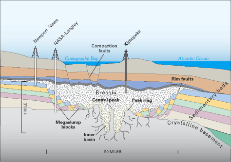
Figure 6 presents a profile view of the crater, along an east west line through Kiptopeke on the Delmarva Peninsula. One can begin to appreciate the extent, immensity and effects of the fracturing that the meteor impact had for tens or hundreds of miles outward from the impact point.

Figure 6. Diagram showing profile view of the complex structure of the Chesapeake Crater. The Sewell’s Point tide gage is some 6 miles south-southeast of NASA-Langley; the crater complex is 50 miles across.
https://upload.wikimedia.org/wikipedia/commons/f/fe/Chesapeake_Crater_profile_view.png
Contrary to the scare stories, including the recent one from NPR, sea levels have been rising at Hampton Roads, Virginia for a long time – certainly since the Wisconsin Ice Age ended, and probably since the Little Ice Age finally thawed out, beginning in the 1800s.
The Sewell’s Point tide gage shows that the rate of sea level rise has not changed since the gage was installed in 1927, and is unchanged from our use of fossil fuels. It’s time to base our policies on sound science, instead of manmade global warming fiction and scare stories.
Robert W. Endlich, resident of Las Cruces, New Mexico, served as a Weather Officer in the U. S. Air Force for 21 Years. From 1984 until 1993 he provided toxic corridor and laser propagation support to the High Energy Laser Systems Test Facility at White Sands Missile Range. He has worked as software instructor and software test engineer at New Mexico State University and published in the technical literature.
He was elected to Chi Epsilon Pi, the national Meteorology Honor Society, while a basic meteorology student at Texas A&M University. He has a bachelor’s degree in geology from Rutgers University and a master’s in meteorology from the Pennsylvania State University.
h/t to Rob Bradley at Master Resource
Yeah, somehow humans can manage to build infrastructure that allows them to work around a daily sea-level rise and fall of over 12 feet in busy ports like Seattle, but that estimated rise of 1 foot per century is gonna really have us baffled? What’s the difference between “advocacy journalism” and propaganda? It’s the noble cause corruption that allows the journalists doing it to wear a halo, while actually doing damage to society through the misdirection of resources. If the “facts” counter the noble narrative, then the facts lose. Doesn’t matter what the issue is.
The example I reference is the Bay of Fundy where sea level changes over 50 feet twice a day, and people fish in those waters. But hoards of ‘climate refugees’ will be ‘baffled’ as you say and not be able to get out of the way of an 1/8th inch annual rise?
Where Ivanka gets her information.
What an excellent posting! The illustrations of the receding shoreline through isostatic readjustment and of the varying rise and fall around North America’s coastline are going straight off to my geography teaching colleagues. Meanwhile, you can only despair at the reason for the posting being necessary in the first place…
http://www.sealevel.info/MSL_mitrovica23_trendtable.html
A good resource, 23 tidal gauges with minimal changes in land levels. Covering Europe, Australasia & the Americas.
Average 1.6mm/year sea level rise.
You don’t graph CO2 overlaid on sea level to prove or disprove a correlation. You graph CO2 in the x-axis and sea level in the y-axis and generate a least square correlation line and look at its correlation coefficient.
If that’s what you do, Donald Kasper, you can find strong spurious correlations between any two things with monotonically increasing trends, as Willis memorably pointed out, a few years ago.
(OTOH, you could plot rate of sea-level rise vs. CO2, and you’d get a roughly horizontal line.)
What is it with all these guys who cut and paste figures from other papers. Don’t these guys ever go get original source data?
Cut and paste blog science. Too funny.
Irony is lost on trolls.
Wow, Steve, that’s a really insightful criticism of the material presented. Devastating, even. /sarc
I have previously posted images of cliff undercuts around the Mediterranian, that appear to demonstrate that there has been no sea-level rise. But here is a similar undercut in the Phillipines.
How old is such a large undercut – 500 years, perhaps? The supposed 5mm/yr sea-level rise over the last 60 years would make sea levels 30 cm higher by now. Does this look like a 30 cm sea-level rise, into that undercut? (The sea here is in a protected bay inside the Phillipine archipelago, so there are no large rollers hitting the cliff.)
It is hardly credible that land rise is exactly the same as sea-level rise, in so many locations, as the sea level rise theory would suggest.
Ralph
These are the similar cliff undercuts in the Mediterranean (where tides are minimal). Notice any sudden sea level rises here? Or are they again proposing that the land has again risen in step with the proposed sea level rises?
Ralf, there is a geologic explanation for these undercuts and why the rock below/above the undercut is not weathered away when sea levels were lower. Personally I do not dispute sea levels are slowly rising, just not with the alarmist spin around it.
https://geographyas.info/coasts/features-of-erosion/
>>there is a geologic explanation
I think you mis-read that explanation. There is no softer layer at that point in these cliffs. And there is no erosion shelf, to reduce the power of the wave. (the Philippines undercut was not simply on the beach, but all around the cliffs)
Had there been lower sea levels a century ago, the notches you can see here would now be partly submerged – even at low tide. But they are not. The low tide is perfectly leveled with the undercut. (Both these pics were taken at low tide, not that Mediterranean tides are worth noting).
R
It needs reiterating that measuring sea level is not a simple matter, because the seas puddle in areas of higher gravity. The sea is up to 150 m higher in some places – see this informative little video:

This is what the Earth and its sea levels actually looks like (below), gravitationally. So the sea around Britain is 150m (490 ft) higher than the sea around the Gulf of Mexico (and no, you cannot surf ‘downhill’ from Britain to Mexico). So measuring a single sea level for the world (and its assumed rise in millimeters per year) is not exactly a straightforward matter.
Ralph
Presumably these gravitational anomalies don’t change much from one century to the next.
>>Presumably these gravitational anomalies don’t change
No. They are dictated by the continents and the thickness/density of the lithosphere, and so they are permanent features on the scale of tens of millions of years.
R
So called “climate change” is a social mania that is thriving on post normal science, post honesty journalism and an increasingly post rational society. NP R has thrived in this environment and is a leader in post honest journalism.
hunter,
I suspect that “post honest journalism” is a non sequitur. It assumes that journalism was at one time actually honest. The function of newspapers has always been to sell newspapers, not to report factual news.
The difference is that 100 and 200 years ago, papers were open about their partisan affiliations.
It’s only been in the last 100 years that reporters and newspapers started to pretend to be nonpartisan.
That makes the reporters of the past, more honest than modern ones.
I read one paper that said Hampton Roads is sinking – that something like 2/3s(?) of the rise is attributable to sinking. I have to get going here, but will try to get back with the link.
Ooops – more than half – apologies for overstating –
Major Conclusions
Land subsidence and global sea-level rise combine to cause relative sea-level rise in the
southern Chesapeake Bay region.
Land subsidence causes more than half of the observed relative sea-level rise.
Aquifer-system compaction causes more than half of the land subsidence.
https://pubs.usgs.gov/circ/1392/pdf/circ1392.pdf
It is a liberal belief considering their constituency, has a core of truth, that people are stupid and need to be lied to for they will do the “right” thing. The Left feels no guilt making stuff up because of this basic premise. Most things liberals say are constructed for the effect they desire rather than any underlying truth.
In other words, they believe that the ends justify the means.
It is a strange, and disturbing, world indeed when the well informed comments above and the author of the detailed ,critical blog himself are berated by an American Professor as mere “dismissives” , whilst the presenters of a report flawed so clearly by the scientific evidence and even by simple common sense, not to mention poor journalistic practice, would instead be applauded by the same Professor for their “scientific” report.
http://i.imgur.com/syALgGu.png
AMOC slowdown effect:
http://i.imgur.com/KY5iaep.png
Thirty yeas just isn’t long enough, JCH. In fact,
“…an interval of just 30 years is the worst that can be chosen because it is half 60-year cycle…” [Nicola Scafetta, 2012]
As the ocean “sloshes” up and down you get significant variations over periods of a few decades or less, but, overall, the trend is very linear.
At first glance, sea-level rise along the southeastern U.S. Atlantic coast, from Virginia to Florida, seems to show a slight acceleration recently. But when the ocean is “sloshing up” in one place, it is “sloshing down” somewhere else.
Remember Sallenger 2012, about a “hot spot” of accelerated sea-level rise along the northeastern U.S. coast? Sallenger compared sea-level trends thirty years apart, and used data through 2009, with emphasis on the trend at New York City. His paper got massive press coverage, and hundreds of citations. But can you guess what sea-level has done there, since then?
http://www.sealevel.info/MSL_graph.php?id=battery&boxcar=1&boxwidth=3&co2=0&g_date=1890/1-2019/12&c_date=2009/12-2016/12&s_date=1890/1-2019/12&thick
http://www.sealevel.info/8518750_The_Battery_1890_to_2017-01_trend_since_2009_no_CO2.png
Of course, that “slosh down” is just as temporary as Sallenger’s “hot spot” was. As surely as night follows day, every “slosh down” will be followed by a “slosh up,” and vice versa.
Sorry I botched that first link.
“The use of long-term GPS data can discern the difference between land subsidence and sea level rise.”
It depends on how the GPS data is benchmarked. If it is benchmarked to land, the same problem exists.
Sorry, I think ‘calibrated’ would be a better term.
GPS can be used to determine if the land is rising or falling, and this value can be added to or subtracted from the value obtained from the tidal gauges to get a better measure of actual SLR.
First, it is differential GPS that is used to sort tide gauges; diff also uses a second land based signal (hence differential). GPS works off the timing differences (at speed of light) from atomic clocks. So there is no calibration to land. There are about 200 PSMSL tide gauges within 10 km of a diff GPS land correction, but only about 70″of those have reasonably long records, and only about 40 that go back 100 years or more.
A GPS receiver can derive its position relative to the satellite constellation, but orbits decay and errors creep in, so there has to be a calibration at some point. Just as augmentation systems like LBAS or WAAS provide correction signals for ionospheric conditions, there must be an overall system calibration. I just don’t know how it is done. I understand how relative position is derived but I am not clear on how it defines an absolute position.
My understanding is that GRASP and/or eGRASP ever fly they are supposed to help address this problem. I don’t know the details, though.
Except that actual statistical analysis has shown accelerating sea-level rise; except that subsidence is hardly news to anybody, least of all those seriously studying the topic; and except that dismissing CO2′ s effect on sea level because one can’t eyeball a correlation on a graph is pretty silly given the noise level of the SLR signal and the understanding we have of the physical processes involved; except for those gaffes, good article!
Doc Snow, the “accelerating sea-level rise” ceased when CO2 rose above 310 ppmv. There’s been no significant, sustained sea-level rise acceleration since the 1920s.
Ref: https://link.springer.com/article/10.1007%2Fs11069-012-0159-8
The SLR is real, although the causes are numerous and difficult to disentangle. This acceleration you are talking about, however, is not global and not statistically significant.
Care to provide a link to this paper that proves accelerating SLR?
Just commenting on the NPR bias. The truth is simple, when you are selling a product, in this case a reason to undercut civilization and reverse it, along with depopulation, which would be the natural result of enacting measures on climate change, you have to “stick to the script,” no matter what comes up or how often it is disproved. To do less will not sell the product, and that is your reason for being – sell the product. Since the media, both public run and main stream, are committed to selling the product, they have no choice but to continue the propaganda. Their very life blood depends on it. Scientific argument is meaningless to them because they can’t change course without literally dying, since doing so would make them obsolete. Actually, breaking step might well save them, or at least return some credibility and utility, but that would be in the long run, not the short run.
That reminds me of the hour-long interview I heard on NPR a few years ago that gave an open mic to a senior marijuana advocacy lobbyist. He listed all the health cures and benefits of marijuana and research studies in rapid fire mode just like the snake oil salesmen of 1800s.
Meanwhile….
https://www.sciencedaily.com/releases/2016/10/161005160733.htm
https://www.sciencedaily.com/releases/2014/11/141110161123.htm
https://www.sciencedaily.com/releases/2016/02/160210135334.htm
https://www.sciencedaily.com/releases/2013/12/131216080454.htm
https://www.sciencedaily.com/releases/2014/04/140415203807.htm
https://www.sciencedaily.com/releases/2016/03/160316105703.htm
https://www.sciencedaily.com/releases/2017/02/170210131220.htm
I never understand why these posts about sea level never even include the word “eustasy”.
Robert Endlich ==> The nearest Continuously Operating Reference Station (CORS) monitoring land movement is LOYZ (LOYOLA Z, Suffolk, VA). The current vertical movement is shown in the graph here. In the Norfolk, Va area, the land is moving towards the center of the Earth at about 1.5-2.0 mm per year. This is typical for northern Virginia.
Areas nearby, like Portsmouth, VA (built mostly on fill) are subsiding at greater rates.
Thank you, Kip, for that CORS link. However, I don’t think that’s a trustworthy subsidence estimate for Sewell’s Point.
In the first place, the CORS data for Suffolk looks awfully rough, to me. This is their graph (cropped):
http://sealevel.info/Suffolk_VA_CORS.png
In the second place, Suffolk is probably experiencing less subsidence than Sewell’s Point, perhaps a lot less. Suffolk is only about 15 miles from the NC border. and I know that here In eastern NC, and so I presume also in southern Virginia, the local geological structure causes subsidence to decrease as you move either west/inland or south, and to increase as you move either east/seaward or north. Suffolk is 20-25 miles southwest of Sewell’s Point, and nearly twice as far as Sewell’s Point from the center of the bolide impact crater, so it’s a safe bet that Suffolk is experiencing less subsidence than Sewell’s Point. (Sorry, I don’t know how much less.)
daveburton ==> Suffolk is the nearest operating COS station, and gives a good idea of the land mass movement. Sewell Point, which I sailed past just last week (7.5 kts SOG in 30 kt winds) ids built on fill, like Portsmouth’s Hospital Point. One can be assured that the land there is subsiding more rapidly than the solid land mass. As one sees in the Google sat image, Sewell Point is built out into the river mouth, where several large rivers feed into the tidal Chesapeake Bay.
For Sewell, the problem is the land is sinking a lot, while the sea rises a little.
In the end, it makes no difference for the need to raise the base land level. One just can’t blame global sea level rise for the problems there.
Wow, sounds like a wild ride! I rode by there in an old sailboat a few years ago, but the mast had failed earlier in the trip, so we putt-putted through there on diesel.
http://sealevel.info/IMG_20130914_131812.jpg
Um, there’s one huge flaw with your analysis. Look up how much water is in the oceans, now look up the how much water comes from all the events you’re listing. Your saying a 1/100th of a drop of water is responsible for an extra inch in the rise of water in a bathtub.
If you want to actually calculate it, you can find simple conversion factors here.
“If you can’t quantify it, you don’t understand it.” -Peter Drucker
The mass of average dumb s___ and the low brow sources feeding them depict sea level as flat line …. UNTIL …. ayyyyyyy geeeeeeee doublllllllle yuuuuuuuuu! The actual reality, the long rise from the Great Melt onward, with something superimposed, is never mentioned nor discussed. The only real point of discussion is what the the superposed term and how long will it be superposed? In the grand scheme, the rise will end when the interglacial ends. Done. Full stop.
Roflol. Thats a big seal. “average seal level rise of 5.37 mm/year.”. (Sic)
Please correct ‘seal’ to ‘sea’ and delete this reply when. Done.
Must be true, the galciers are melting because of CAGW: Sciencemag says: http://science.sciencemag.org/content/356/6338/580.full
No commets for 2 days and I know for sure, that they have received at least one eLetter.
Pls, correct “glaciers”.
“At the end of the Wisconsin Ice Age 20,000 years ago, sea levels were some 400 feet lower than they are today.” Let’s do some math: 400 feet divided by 20,000 years is 0.02 feet (6.1 mm) per year, or 2 feet (24 inches, about 61 mm) per century. It seems the current rate of sea level rise (aside from local geological effects) is about the same or less than it has been for 20,000 years.
Oops! Make that 610 mm per century.