This summer there will be lots of fun and rejoicing on California lakes and reservoirs, many of which are now nearly full thanks to a strong El Niño in the winter of 2015/2016 that produced copious amounts of rain and snow in March. Many in California have started thinking that the drought is over, no more worries. They couldn’t be more wrong.
The drought that produced images like this one are the result of La Niña conditions in the tropical Pacific.What a difference a year makes.

Now, based on observations and forecasts, it looks like January 13th 2017 will look a lot like January 13th, 2014.
First, the observations.
Bob Tisdale pointed out the observed changes in a recent WUWT post: For Those Watching the Sea Surface Temperature Anomalies of the Equatorial Pacific and the Decay of the El Niño
The latest sea surface temperature anomaly map from the CMC Environment Canada (Figure 1) shows cooler than normal sea surface temperature anomalies along the equatorial Pacific east of about 125W, indicating the tropical Pacific is heading toward La Niña conditions. (Note the odd base years for anomalies used by CMC Environment Canada, 1995 to 2009.)
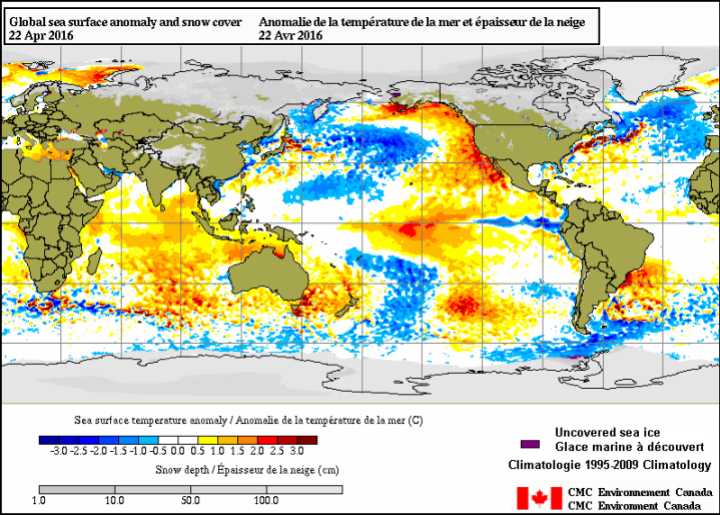
Figure 1 Source is here.
He adds:
The sea surface temperature anomalies for the easternmost NINO1+2 region have dropped well below zero (-0.6 deg C). Those in the NINO3 region have dropped to weak El Niño conditions and the NINO3.4 region continues to follow.

Joe Bastardi of Weatherbell notes:
Some sharp temp drops showing up in temps now as el nino rapidly backs off. Well forecasted spike, cooling starting

Now the forecasts.


Joe Bastardi of Weatherbell noted this about Figure 4 on Twitter:
Aug-Oct CFSV2 implications.High impact Hurricane season with atlantic warmth/la nina. Arctic coldest in many years
Arctic sea ice decline, if in fact driven by surface temperature, might not be as disastrous as is being predicted when the September melt peak comes around. But more worrisome will be the late Atlantic Hurricane season and water supplies for the west coast.
The Klotzbach/Gray hurricane forecast for 2016 states:
We anticipate that the 2016 Atlantic basin hurricane season will have approximately average activity. The current weakening El Niño is likely to transition to either neutral or La Niña conditions by the peak of the Atlantic hurricane season. While the tropical Atlantic is relatively warm, the far North Atlantic is quite cold, potentially indicative of a negative phase of the Atlantic Multi-Decadal Oscillation. We anticipate a near-average probability for major hurricanes making landfall along the United States coastline and in the Caribbean. As is the case with all hurricane seasons, coastal residents are reminded that it only takes one hurricane making landfall to make it an active season for them. They should prepare the same for every season, regardless of how much activity is predicted
La Niña conditions in the tropical Pacific mean a drier water year for the U.S. West Coast due to a blocking high pressure ridge:
![ENSO_pic[1]](https://wattsupwiththat.files.wordpress.com/2014/06/enso_pic1.jpg?quality=83)
California still hasn’t learned anything from the last water crisis, and still isn’t building any new water storage infrastructure. It may take a mega-drought before they finally decide survival of the state is more important than the greenies’ wailing objections to new reservoirs. It’s not a matter of if, but when.

Glad to hear that some parts of CA received above normal rainfall. I live in San Luis Obispo, CA and we received below average rainfall. Even though we would have to move (and it would kill me to leave all of my fruit trees) if the drought continues I do not want to see more reservoirs built. More reservoirs means more people and the destruction of more wildlife habitat.
One of the great impediments to modern life is the plethora of Greenies sitting on their butts, howling about and railing against people building dams and nuclear power stations. If they could be released from their groundless delusions, they could return to the advance of civilisation.
large negative AO for last month. Does this mean any freezing recently in North East USA?
If the reservoirs are full, by definition the drought is over. Anticipating a future drought does not mean we have a drought now.
Historically, strong El Ninos are followed by colder than normal La Ninas, so we should have a cold and dry winter this year, at least for the US West Coast…
I feel sorry for my California friends that will likely suffer through below normal precipitation levels this winter because of the coming cold La Nina.
California must spend massive amounts of money to build more reservoirs and should also build desalinization plants in Los Angles and San Diago to meet the water needs of a growing population..
California must also immediately stop wasting billions of gallons of water by needless dumping water into rivers to “Save the River Smelt!”, and hold the water in reserve to “Save the Farmers” and “Save Californians”…. but alas…. California is run by Leftist lunatics that are incapable of logical thought.
Of course Californian Leftists loons will blame the coming California drought on CAGW, rather than correctly attributing it to the coming colder than normal La Nina…
BTW, the new weekly Nino3.4 SST Index came out today: fell 0.21C in one week (from 1.02C to 0.81S) … Oh, my…:
http://www.bom.gov.au/climate/enso/monitoring/nino3_4.png
BTW, you have to click on the above graph to get current NINO3.4 numbers….
I don’t know why….
We also need to stop wasting water growing alfalfa and the like. Irrigation should be reserved for high nutrition crops that can be eaten by Americans.
ahem.
alfalfa feeds cows, which results in tri-tip roasts, which are an essential part of the #Failifornia diet.
what we need to do is stop wasting water on kale, arugula, and other foodie garbage so beloved of the delusional tourists who moved here from back east and ruined Paradise.
Tri tip from range fed steers is the only way to go.
This is looking really bad. It is going to be our harsh reality until PDO flips warm (and by that I don’t mean the sort of “fake out” minor flip we saw a couple years ago, I mean flips and stays warm for ten or more years).