I found this post interesting, especially after looking at some of the images that show what appears to be a tight hot spot upwelling off the coast of Costa Rica. But I simply can’t see enough energy in this venting to account for the massive energies dissipating in ENSO events. But, let’s give it a shakedown. I welcome comments from readers on this topic. – Anthony
Argo Data Confirms El Niño/El Niña Caused By Underwater Volcanoes
Guest post by AJ Strata of The Strata-Sphere
Last week I postulated that the El Niño/El Niña effect was not due to solar or atmospheric conditions, but actually caused by underwater volcanic activity along ocean ridges off the West coast of South America. To see whether my theory held water I decided to look into the Argo Float data to see if there it was showing a warm upwelling of water in this region. I apparently was correct.
My initial assessment was that the frigid Humboldt Current that comes north from the Antarctic region along the west coast of South America (the mirror image of the current that drops down from the Arctic along the west coast of North America) could not be warmed so drastically in such a short time by sun and air alone. This is due to the physics of ocean currents and the massive amount of heat required to warm tons of cold water moving northward per second:
Gyres are caused by the Coriolis Effect; planetary vorticity along with horizontal and vertical friction, which determine the circulation patterns from the wind curl (torque).[1] The term gyre can be used to refer to any type of vortex in the air or the sea, even one that is man-made, but it is most commonly used in oceanography to refer to the major ocean systems.
…
The “South Pacific Gyre” is the Earth’s biggest system of rotating ocean currents, bounded by equator to the north, Australia to the west, the Antarctic Circumpolar Current to the south, and South America to the east.
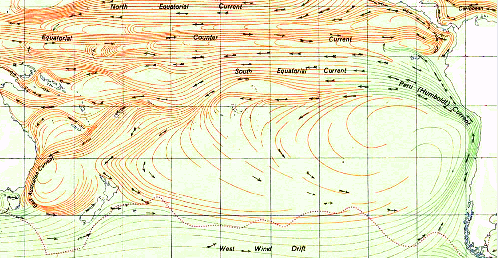
As can be seen in the graph above (click to enlarge), the Humboldt Current is one of the largest on the planet. It is infeasible that El Niño can arise from atmosphere and sun alone by warming this mass of water. Neither air temp or solar radiance change enough to cause this phenomena.
At this site you can watch animation of nearly 5 years of Argo data on the tropical region of the Pacific Ocean. It is fascinating and proves my earlier conclusion that the warm waters of El Niño arise from the eastern pacific and travel west – not the reverse as is the current (now defunct) theory. You need to set the start date on the left to the earliest date in 2007 and the end date to the latest in 2012.
I suggest you first watch the surface animation, then go the the 100m data. What you will see in the 100m is hot water upwelling off the coast of Costa Rica (which was not in the zone I originally predicted the upwelling would occur BTW). I have taken a few snaps of the data from Oct 2008 to Feb 2009 at 4 week interval to highlight what I discovered.
On this first image (click to enlarge) we see the very beginnings of the upwelling off the coast of Central America (area highlighted by red rectangle with a small blue dot). As time progresses the upwelling grows, moves west and another upwelling appears. The images are from 10_22_2008, 11_26_2008, 12_24_2008, 1_21_2009 and 2_25_2009.


Now some may ask why didn’t Argos detect the upwelling deeper (1000m)? The answer is in fluid dynamics. The hot spot is very narrow above whatever thermal vents are the source of this warming. The Argo floats are not very dense in this region. So the warm column of water upwelling has to spread out as it rises, making it more likely to be detected by the Argos floats. By the time it hits the surface the warm water really spreads out over top of the cooler layers below.
As this March 2009 surface image shows there are two upwellings in the area, but the one off Costa Rica is missed at the lower depths (again likely due to the density of sensors being so low in this area). And there appears to be a 3rd upwelling off the coast of Peru.

The activity of Nicaragua and Costa Rica is right along the Cocos Plate.

The Peruvian region I highlighted in the previous post and is linked to the Pacific Rise. Higher volcanic activity in these areas clearly cause more warm water to rise and heat the surface, creating the conditions for El Niño. Lower activity allows the cooler currents to dominate, bringing on El Niña.
… and since climate affects volcanoes …
El Niño/La Niña, please…
The SMU has the a good online reference for the geothermal flux and really it says that we know very little about it. Hot spots in the USA have up to 15Wm-2, so it seems almost obvious that there must be vast hot spots on the ocean. The other aspect of the SMU studies and papers is that the variation of the flux over time has also not been quantified, we have no idea how much it varies over any time scale.
http://smu.edu/geothermal/heatflow/heatflow.htm
I think it’s pretty well established that changes in the trade winds are what cause the ENSO. Winds can push a lot of water from one place to another but more importantly those winds can evaporate, or not, a lot of water and evaporation is extraordinarily powerful at removing heat and when they’re not blowing at allowing heat to build up in the surface layer and not mix downwards.
Internal heat from the planet leaking through volcanoes isn’t enough, directly, to cause ENSO. Plus one would have to come up with something rather fast and cyclical to inject, or not, enough hot water. Volcanoes aren’t known for fast cyclical behavior. Individually they are slowly repeating over centuries and millienia but not rapidly repeating over years and decades. Plus a whole line of them tends to be not cyclical at all but rather collectively constant. I think Anthony’s instincts there are well founded. But that’s not to say it couldn’t indirectly be doing it. A major volcanic eruption on the surface can certainly alter the climate for years indirectly through stratospheric particulates from the eruption blocking sunlight. You should probably look for some indirect method where the upwelling warm water has an effect on the trade winds which in turn drives the ENSO. The fast cyclical nature is still what bothers me because that’s just not typical of volcanic activity.
I mean, vast quantities of thermally heated, super-hot water at up to 400 degrees Centigrade belching out of long chains of submarine black smokers HAVE to have at least SOME effect on the ocean currents above.
May be worth a closer look, IMHO.
The plate boundary off the west coast of central America is a subduction zone so there are no volcanoes along it but on land as the last graphic shows. There are ridges, with attendant volcanic activity, further out but along the western edge of the Cocos plate which is some way from your upwelling.
The volcanic activity above the subducted plate is around 150Km from the subduction boundary but does depend on the subduction angle. The steeper the subduction the closer the volcanic activity, the shallower the further away as is evident in Chile where there is a long swathe of subduction without the volcanoes.
So I am afraid I cannot shine any light on your observations.
Certainly seems more plausible than atmosphere. You could do a cheap physical model with a big shallow pan full of viscous fluid and an immersible coffee heater.
By a hurried back-of-the-envelope, it’s not totally ridiculous. Volcanoes can pack 1e19J in an event. That is enough energy to heat the 20-meter mixed layer 2.5C (at 10J/liter) (the difference between green and red on those maps above) for 50 million square kilometers of ocean.
Not sure I see it. Volcanoes can be active all the time, some of the time, very little of the time… some can be dormant for centuries, then have huge eruptions for months or years. It seems to me that there would be hotter spots/spikes, in the regions where volcanoes are grouped together. Of course, I am writing this on the fly- I’ve got a barn full of animals to deal with in a few minutes- and I haven’t had time to go over it all properly.
Well these hotspots are pretty real and their volcanic origin seems pretty likely but I don’t believe they are the only thing behind El Nino/La Nina. They may cause a temperature inversion to break up, acting as the trigger event, but the inversion must be there first and that’s much more energy than what’s in these tiny hotspots.
However – we all know Earth is hot inside. The deeper you go in mines, the higher the temperature is. How comes ocean bottoms are so cool? The only explanation is – it’s because the cool water there was originally cooled down in polar areas. And I believe the whole ocean bottom is one extraordinary warming plate, warming the deepest waters by tiny amounts but with a lot of energy involved due to the large area. This, and dynamic effects (such as temperature inversions) related to it may be the major cause of El Nino/La Nina.
Very interesting hypothesis.
One thing to think about: Piers Corbyn has been saying (and is now making predictions based on it) that CMEs which hit earth’s atmosphere have effect on earthquakes (perhaps he should look for similar links to volcanoes?), which may mean that the link between solar factors and ENSO modulations is possible, albeit through an amplifying mechanism using the earth’s magnetosphere, inner core and thermal venting.
Interesting to see how the science pans out………
I think it`s pretty obivous from those temperature maps that at the Central American end, some of the warming starts from Volcanic events. But like many people have said, that cant be enough to warm the whole south pacific (it certainly CAN’T). So obviously there is something else that causes an amplicification/feedback that increases these power of these hotspots – the Trade Winds ? the Humboldt Current ? Solar ? Maybe these 3 hotspots (and it`s probably many more), cause a local upwelling current that interferes with the Thermohaline and Halothermal circulation
Perhaps a full look into the ocean depths at these so called smokers will show up more as a crack in the earths crust. The smoker parts as the most obvious, the crack maybe hundreds of miles long and some miles wide, The surface being in constant quench and heating billions of tons of water. The smokers may be the smoking gun.
Volcanoes and earth tremors are triggered by the machinations of the sun, thus this heat source may be cyclical as also is the sun.
{ this is the missing heat Trenbeth forcast, maybe ,perhaps tho’ it does not help his CO2 cause much}
The sun varies not just the heat of our atmosphere but stirs also the bowels of the Earth.
Is there a philanthropist who willing to support an expedition with a task to measure the thermal gradient between the ocean floor (sediment) and the ocean (water) at 1-5-10 and 100m from the bottom.
Just 0.1 deg K / big surface-area / long time, thermal difference enough in the long run to modify currents. May be not need to have small/hot spot. Just a “Yellowstone” under the sea!!
Perhaps a mathematically skilled can do a “backward” calculation: what kind of “heat-flow” need to influence “x” degree of temp on the top and “y” m/s speed of current change.
But, perhaps the ocean currents/conveyor-belts is “locked” with gravity/solar-system/spin instead of thermal flux/temp-gradient.
The ocean bed is cooler the further away from the constructive ridge you go. Sea water temperature at the floor is between 2-0C so cools the sea bed. As the subduction zone is approached the water depth increases due to the cooling of the ocean crust from the 1200C erupted to that of the cold subducted crust. Depths are 2,5Km at the ridge to 6 or more Km at the subduction zone and even deeper at the line of subduction, the deepest trench is 11Km deep. So subducting crust is cold therefore no volcanism. As the subducting crust gets deeper it warms up and when the temperature gets to 760C or so starts to melt with water acting to lower the melting point and volcanoes are formed by the rising melt, inland in the case of S America and forming ocean arcs of islands in the case of ocean crust/ocean crust subduction with Japan as the best example.
I repeat, there is no volcanic activity below the point of the ocean hot spot that is so close to Costa Rica.
Interesting idea. It’s about that which triggers the variation in the cycles, not the cycles themselves. So one has to explain the periodicity as noted above. But I would also have thought the trigger point occur at well-known hotspots like Galapagos than off of the Cocos spreading center (Barkhausen et al 2001 (JGR), Harpp et al. 2005 (j Petrology)….? I haven’t overlaid maps of known volcanoes – but then again I haven’t even had my first cup coffee. First things first.
;-D
This is just an upwelling area mostly caused by the North Equatorial Counter Current (which flows to the East at 5N-10N) and its interaction with the coast, various other ocean currents and the winds which are still primarily to the west here. The coastal upwelling is composed of three different upwelling gyres, Tehuantepec, the Costa Rica Dome and the Gulf of Panama. The thermocline is right at the surface in these three upwells and they alternate between warm and cold upwelling.
Well, it makes sense that Indonesia is such a hot spot, what with the massive amount of volcanoes and vents in that part of the ring of fire, and south and central america are not it’s equal.
If it fits with the Atlantic and Indian oceans too…
oceanexplorer at noaa has bunch of info on the ring of fire. It’s sad nobody seem to know in what range the amount of submarine vents and volcanoes numbers.
Surfer Dave says:
February 15, 2012 at 2:23 am
The SMU has the a good online reference for the geothermal flux and really it says that we know very little about it. Hot spots in the USA have up to 15Wm-2, so it seems almost obvious that there must be vast hot spots on the ocean. The other aspect of the SMU studies and papers is that the variation of the flux over time has also not been quantified, we have no idea how much it varies over any time scale.
===================================================
Dave, we also must consider that the mean crust thickness is close to 11 miles on land, and ONLY three miles in the oceans. Someone will comment that boreholes meausre only a very small heat flux.1 to .2 W/m2, but as far as I know this is land meausrements. In large parts of the ocean we do not know the residence time of the input from geo thermal heat, or the amount of active volcanism within the thinner crust ocean basins, We do keep finding more. Now if this heats residenced time is days, weeks years, and in some areas centuries, then a lot of heat can accualate over that time frame.
In regard to ENSO I think “Just the Facts, in his post just below yours, makes logical statements concerning this.
I want thank Anthony for the opportunity to post here and I look forward to all the insightful comments his readers will provide. It is a rare privilege to get this kind of high powered review.
As to the idea a few volcanoes (and we don’t know how many there are in this active tectonic area) cannot heat that much water and it must be air and sun, I have to note once more that I found a source in the prior post stating a current like the Humbolt pushes tons of water a second.
My recollection of heat capacity between air and water would indicate to me the air might cool before the water warmed when we’re talking that kind of mass of frigid water flowing. The number was for the similar sized Gulf current on the east coast of North America.
I would assume we are dealing with a lot of thermal vents. Some could even be more like geysers than volcanoes. We just don’t know enough about this area of the planet to make broad assumptions. Looking forward to the discussion.
@Kasuha, it’s because water at different temperatures has different density, and the densest and therefore heaviest water will go to the bottom of the ocean (if there are no other ocanic currents preventing it), and that’s water at 4C (277K), if I don’t remember wrong.
This is a topic that Robert Felix at Ice Age Now has been discussing for years. I think it would be well worth the effort to read his posts on the subject. Here’s the link: http://iceagenow.info/category/volcanoes-leading-us-into-an-ice-age/submarine-volcanoes-more-important-than-we-realize/
Interesting. Ever since I first saw pillow lava formation in an undergrad geology video I’ve been impressed with the amount of heat being liberated into the oceans. Of course many people have looked into the energy balance and come to the conclusion that the geothermal contribution to the ocean’s heat is relatively minor. That’s unintuitive though. That magma at ocean spreading ridges is damn hot and it only going to cool by heating sea water. Then there is the hydrodynamics of black smokers. How much percolation of cold seawater into the seafloor takes place, being pumped out at superheated temps (what would/could that do to isotope ratios? :)?
Of course, so far as I can see, the experiments an mapping needed to REALLY answer the energy budget questions just haven’t been done (expensive and hard), and even if they were, the temporal variability would still be uncertain…
Someone in another post on another thread pointed me back to another amazing diagram I’d seen some years ago and promptly forgotten about:
http://ga.water.usgs.gov/edu/earthhowmuch.html
Looking at that, there isn’t really that much water there so I could easily see geothermal being a substantial contribution, and variable over time too. Sure, wind moves the surface water around and that steer currents, but it would make sense if the heat from the rocks underneath that actually drive them.
Follow the money/energy and there’s a LOT in that there mantle and core. Keep asking those questions…
I have looked into this some 18 months ago and indeed there is a natural process, as yet not recognised by the science, which correlates well with the Southern Oscillation.
http://www.vukcevic.talktalk.net/SOI.htm
ALSO, it would be interesting to do the math (I can’t do math, I’m from Texas) on underwater volcanism’s effect on the CO2 saturation of ocean water, which is such a source of despair for warmistas.