2007: Impassable Northwest Passage Open For First Time In History
2010: Ship find shows Arctic Sea Ice conditions similar to 1853
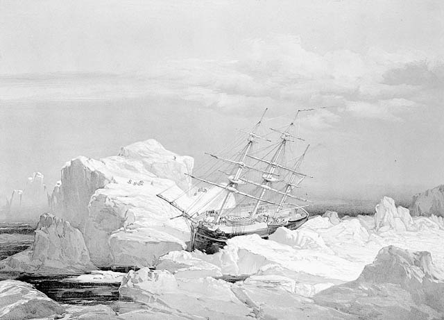
The international news media are hailing the archaeological find of a British naval ship the HMS Investigator on July 25 in an area far north (600 km) of the Arctic Circle that was previously unreachable due to sea ice. The HMS Investigator was abandoned in 1853, but not before sailing the last leg of the elusive Northwest Passage.
From AP/MSNBC:
Captained by Robert McClure, the Investigator sailed in 1850. That year, McClure sailed the Investigator into the strait that now bears his name and realized that he was in the final leg of the Northwest Passage, the sea route across North America.
But before he could sail into the Beaufort Sea, the ship was blocked by pack ice and forced to winter-over in Prince of Wales Strait along the east coast of Banks Island.
From the Hockey Schtick: The ship had been sent on a rescue mission for 2 other ships mapping the Northwest Passage. Now, thanks to “climate change,” archaeologists working for Parks Canada were finally able to plot a small window of time this summer to allow passage to the ship’s location:
Parks Canada had been plotting the discovery of the three ships for more than a year, trying to figure out how to get the crews so far north. Once they arrived and got their bearings, the task seemed easier than originally thought. It took little more than 15 minutes to uncover the Investigator, officials told The Globe and Mail last week. “For a long time the area wasn’t open, but now it is because of climate change,” said Marc-André Bernier, chief of the Underwater Archaeology Service at Parks Canada.
Interesting that the ship was lost in 1853, right at the end of the Little Ice Age, and coincidentally just 3 years after the start of the HADCRU global temperature record, from which we are led to believe the earth has warmed about 0.7C. If we are seeing “unprecedented” global temperatures and changes in Arctic sea ice, how did the HMS Investigator get this far north at the end of the Little Ice Age?
Here’s the location:

Video of the find:
Theo Goodwin says:
August 6, 2010 at 8:23 am
…..
Embracing glaring self-contradiction is one way to never be at a loss for words.
—————————-
Spot on!
That’s what AGW proponents are increasingly reduced to – glaring self-contradiction – which they are forced to embrace, because they have painted themselves into a corner with their failed predictions.
Actually, the truth doesn’t seem to matter to the elite of this movement, but we knew that (they’ve even said it themselves).
Guido Guidi says:
August 6, 2010 at 8:30 am
Hey Antony,
it looks like this time I got you!
http://www.climatemonitor.it/?p=11973
🙂
Hey Guido, it’s in Italian! 🙂
The warmistas worst nightmare is NOW OCCURRING
http://ocean.dmi.dk/arctic/icecover.uk.php
I came across this some time back and kept a copy. I also read somewhere, but can’t find it just now, that a Chinese squadron, in the 1400s, sailed around all of the area north of Canada and there wasn’t a sign of ice. Is there anyone out there who knows about this?
Travellers through the Northwest Passage 1906 to 2007 A.D.
Amundsen expedition
Main article: Roald Amundsen
The Northwest Passage was not conquered by sea until 1906, when the Norwegian explorer Roald Amundsen, who had sailed just in time to escape creditors seeking to stop the expedition, completed a three-year voyage in the converted 47-ton herring boat Gjøa. At the end of this trip, he walked into the city of Eagle, Alaska, and sent a telegram announcing his success. Although his chosen east–west route, via the Rae Strait, contained young ice and thus was navigable, some of the waterways were extremely shallow making the route commercially impractical.
[edit] Later expeditions
The first traversal of the Northwest Passage via dog sled[30] was accomplished by Greenlander Knud Rasmussen while on the Fifth Thule Expedition (1921–1924). Rasmussen, and two Greenland Inuit, travelled from the Atlantic to the Pacific over the course of 16 months via dog sled.
In 1940, Canadian RCMP officer Henry Larsen was the second to sail the passage, crossing west to east, from Vancouver to Halifax. More than once on this trip, it was unknown whether the St. Roch a Royal Canadian Mounted Police “ice-fortified” schooner would survive the ravages of the sea ice. At one point, Larsen wondered “if we had come this far only to be crushed like a nut on a shoal and then buried by the ice.” The ship and all but one of her crew survived the winter on Boothia Peninsula. Each of the men on the trip was awarded a medal by Canada’s sovereign, King George VI, in recognition of this notable feat of Arctic navigation.
Later in 1944, Larsen’s return trip was far more swift than his first; the 28 months he took on his first trip was significantly reduced, setting the mark for having traversed it in a single season. The ship followed a more northerly partially uncharted route, and it also had extensive upgrades.
On July 1, 1957, the United States Coast Guard cutter Storis departed in company with U.S. Coast Guard cutters Bramble (WLB-392) and SPAR (WLB-403) to search for a deep draft channel through the Arctic Ocean and to collect hydrographic information. Upon her return to Greenland waters, the Storis became the first U.S.-registered vessel to circumnavigate North America. Shortly after her return in late 1957, she was reassigned to her new home port of Kodiak, Alaska.
In 1969, the SS Manhattan made the passage, accompanied by the Canadian icebreaker Sir John A. Macdonald. The Manhattan was a specially reinforced supertanker sent to test the viability of the passage for the transport of oil. While the Manhattan succeeded, the route was deemed not to be cost effective, and the Alaska Pipeline was built instead.
In June 1977, sailor Willy de Roos left Belgium to attempt the Northwest Passage in his 13.8 m (45 ft) steel yacht Williwaw. He reached the Bering Strait in September and after a stopover in Victoria, British Columbia, went on to round Cape Horn and sail back to Belgium, thus being the first sailor to circumnavigate the Americas entirely by ship.[31]
In 1984, the commercial passenger vessel MS Explorer (which sank in the Antarctic Ocean in 2007) became the first cruise ship to navigate the Northwest Passage.[32]
In July 1986, Jeff MacInnis and Wade Rowland set out on an 18 foot catamaran called Perception on a 100 day sail, West to East, across the Northwest Passage.[33]link CBC panel discussion. This pair is the first to sail the passage, although they had the benefit of doing over a couple summers.
In July 1986, David Scott Cowper set out from England in a 12.8 m (42 ft) lifeboat, the Mabel El Holland, and survived 3 Arctic winters in the Northwest Passage before reaching the Bering Strait in August 1989. He then continued around the world via the Cape of Good Hope to arrive back on 24 September 1990, becoming the first vessel to circumnavigate the world via the Northwest Passage.[34]
On July 1, 2000, the Royal Canadian Mounted Police patrol vessel Nadon, having assumed the name St Roch II, departed Vancouver on a “Voyage of Rediscovery”. Nadon’s mission was to circumnavigate North America via the Northwest Passage and the Panama Canal, recreating the epic voyage of her predecessor, St. Roch. The 22,000 mile Voyage of Rediscovery was intended to raise awareness concerning St. Roch and kick-off the fundraising efforts necessary to ensure St. Roch’s continued preservation. The voyage was organized by the Vancouver Maritime Museum and supported by a variety of corporate sponsors and agencies of the Canadian government. Nadon is an aluminum, catamaran-hulled, high-speed patrol vessel. To make the voyage possible, she was escorted and supported by the Canadian Coast Guard icebreaker Simon Fraser. The Coast Guard vessel was chartered by the Voyage of Rediscovery and crewed by volunteers. Throughout the voyage, she provided a variety of necessary services, including provisions and spares, fuel and water, helicopter facilities, and ice escort; she also conducted oceanographic research during the voyage. The Voyage of Rediscovery was completed in five and a half months, with Nadon arriving back at Vancouver on December 16, 2000.
On September 1, 2001, Northabout, an 14.3 m (47 ft) aluminium sailboat with diesel engine,[35] built and captained by Jarlath Cunnane, completed the Northwest Passage east-to-west from Ireland to the Bering Strait. The voyage from the Atlantic to the Pacific was completed in 24 days. The Northabout then cruised in Canada for two years before it returned to Ireland in 2005 via the Northeast Passage thereby completing the first east-to-west circumnavigation of the pole by a single sailboat. The Northeast Passage return along the coast of Russia was slower, starting in 2004, with an ice stop and winter over in Khatanga, Siberia—hence the return to Ireland via the Norwegian coast in October 2005. On January 18, 2006, the Cruising Club of America awarded Jarlath Cunnane their Blue Water Medal, an award for “meritorious seamanship and adventure upon the sea displayed by amateur sailors of all nationalities.”
On July 18, 2003, a father and son team, Richard and Andrew Wood, with Zoe Birchenough, sailed the yacht Norwegian Blue into the Bering Strait. Two months later she sailed into the Davis Strait to become the first British yacht to transit the Northwest Passage from west to east. She also became the only British vessel to complete the Northwest Passage in one season, as well as the only British sailing yacht to return from there to British waters.[36]
On May 19, 2007, a French sailor, Sébastien Roubinet, and one other crew member left Anchorage, Alaska, in Babouche, a 7.5 m (25 ft) ice catamaran designed to sail on water and slide over ice. The goal was to navigate west to east through the Northwest Passage by sail only. Following a journey of more than 7,200 km (4,474 mi), Roubinet reached Greenland on September 9, 2007, thereby completing the first Northwest Passage voyage made without engine in one season.[37]
Ah, but the hobnobs and their weather is climate change crap.
They got there by weather, but were found due climate change.
Hadn’t the climate changed enough to make the weather favorable in the first place?
Verity Jones says:
August 6, 2010 at 9:37 am
> Ric Werme (August 6, 2010 at 8:31 am) – it might be Explorers Web (link)
It was indeed! It looks like they’ll be covering this year’s follies well too. Good to see you’re following the Arctic circumnavigation effort, on Northern Passage, they caught my eye a few months ago by seeming to understand what they’re up against.
The folks with the boat powered by bioethanol, on the other hand, seem to have their priorities misordered.
WUWT readers – monitor the Arctic passages (and other stuff) at http://www.explorersweb.com/oceans/ . It will provide a whole different perspective compared to what we get from the satellite data.
The ship had been sent on a rescue mission for 2 other ships mapping the Northwest Passage.
Neither HMS Investigator nor modern efforts have yet to find the ‘other two’ ships.
Did these 2 ships get even further North?
Are they encapsulated in multi-year ice that (gulp) hasn’t melted yet?
The ‘other two’ ships were on mapping missions.
Peter Walsh says: August 6, 2010 at 11:52 am
You’re probably thinking of Gavin Menzies’ book 1421: The Year the Chinese Discovered America. He makes the claim there that a Chinese fleet sailed into the Atlantic, circled Greenland ,aking maps and may have actually reached the North Pole. He makes an interesting circumstantial case, but there don’t seem to be any definitive accounts: just fascinating tid bits that are open to a variety of explanations. As a long-time Sinophile, I’d like to think it was all true, but I’m convinced.
sheesh. “But I’m NOT convinced.” Read twice before hitting the post comment button.
Peter Walsh says: August 6, 2010 at 11:52 am
Yes. Go to Amazon books and look up “1421” by Gavin Menzies.
This is another area, like Climate Science, where the evidence has so affronted the academic orthodoxy that they set up a website, RealClimate-like, to debunk this tour-de-force of enterprising discovery.
Clue: read the book – ignore the daleks’ D.E.A.T.H.-it approach (Don’t Even Attempt To Hear It)
“Parks Canada had been plotting the discovery of the three ships for more than a year, trying to figure out how to get the crews so far north. ”
Imagine what those intrepid old timers back in the 19th century might have accomplished with the benefit of near realtime satellite ice mapping, GPS navigation, modern communications equipment, and an auxiliary fleet of nuclear powered icebreakers.
This is the same kind of apples and oranges thinking that discovered dramatically increasing tornadoes and hurricanes at exactly that point in time where our technological capability to detect them experienced a quantum improvement.
These clowns couldn’t think their way out of a paper bag.
This is probably the ignorance question of the week… so have mercy folks! :o) Hopefully someone with a better understanding of the geography, currents and ice flows will be willing to address this one and save some of us from having to research it ourselves – but is it possible that rather than managing to sail to where it was found, the ship was trapped in the ice and moved by ice flow a significant distance, to the position in which it was found? Like Nansen’s expedition? Or would ice flow currents have moved the ship an entirely different direction? Or were there records of the ship sailing to this latitude & longitude and that’s how they found it so easily? Thanks in advance for a bit of enlightenment on this issue!
What history:
http://www.ngu.no/en-gb/Aktuelt/2008/Less-ice-in-the-Arctic-Ocean-6000-7000-years-ago/
http://noconsensus.wordpress.com/2009/06/16/historic-variation-in-arctic-ice-tony-b/
http://co2science.org/articles/V12/N32/C2.php
Correction:
What history?
“A stone inscribed with runes has been found telling that in 1333, three Greenlanders wintered on the island of Kingigtorssuaq just below 73 degrees north.”
That is not quite true. There is no year on stone but it is stylistically dated to about 1250-1350. There is no mention of any wintering either, only that the stone was written on April 25. And as “everybody knows” that there couldn’t be open water that early it has just been assumed that they were wintering there. However it is quite possible that there may have been open water that far north in late April during the MWP. The sea off SW Greenland never freezes and it would only take a very slight warming compared to the present to extend this open water to Kingigtorssuaq.
Gail Combs: August 6, 2010 at 9:58 am
They forgot the Norse not to mention the Romans.
Slightly south, but my neighbor (when I’m home) is an archaeologist — last time I was home, he showed me three pictures and asked me where I thought he’d taken them. I looked for a couple of minutes and said, “Crete. It looks like a tholos tomb, but the roof is intact.” He said, “Pocono Mountains.”
Pamela Gray: August 6, 2010 at 10:12 am
If they start finding WWII planes near that site, I’m going back to church.
If they find one on Banks Island, it means the pilot *didn’t* — it’s 1,400 miles west of the ferry routes…
“Neither HMS Investigator nor modern efforts have yet to find the ‘other two’ ships.
Did these 2 ships get even further North?
Are they encapsulated in multi-year ice that (gulp) hasn’t melted yet?”
These two ships were the Franklin expeditions’ HMS Erebus and HSM Terror. We know approximately where they are from the one remaining written record from the Franklin expedition and from inuit testimony. One sank off the northwest coast of King William Land and the other near the mainland coast SW of King William Land. However the positions are only known approximately, and since even in this era of “unprecedented” polar warmth the sea is at best ice-free a few weeks each year they are very diffiocult to find.
Rational Debate says:
August 6, 2010 at 1:21 pm
Read it yourself at the link below. It was 27 days from 17 September to 10 October 1850 from the first encounter with young ice to the time a party first went ashore from the ship. During that time the ship drifted back and forth but less than 20 miles from her first encounter with the young ice on 17 September. On 13 October the ship is described as quite stationary in position 72 47’N 117 35’W.
‘A Personal Narrative of the Discovery of the North West Passage’ by Alex Armstrong MD RN late Surgeon and Naturalist of HMS Investigator published 1857
http://www.archive.org/stream/apersonalnarrat00armsgoog#page/n264/mode/1up
Rational Debate: August 6, 2010 at 1:21 pm
This is probably the ignorance question of the week…
Relax — asking questions cures ignorance.
…were there records of the ship sailing to this latitude & longitude and that’s how they found it so easily?
Absolutely correct! The ship’s location was known, and the seams had been opened by the ice after three years, which is probably why it was abandoned — it was no longer seaworthy. One summer, enough seawater had collected in the hull to sink it, and when the ice couldn’t support the ship’s weight any more, down she went.
If you want to know how they got there, read
The Arctic Grail: The Quest for the Northwest Passage and The North Pole, 1818-1909 by Berton.
A terrific comprehensive history. The natives, whalers, and later English learned centuries ago that there were good ice years and bad ones, sometimes consecutively. The difference between finding a route or seeing an strait of open water or getting out of a winter anchorage was often luck. Bad luck often meant scurvy, starvation and death. Were they not rescued, it’s doubtful anyone would have credited McClure with the first discovery. The party was mounting up for a sledge trip out to rescue themselves, nearly starved, after 3 years of entrapment that certainly would have killed them all (read what happened to Franklin and his party).
Also interestingly, the fundrasing hype of the day for exploration then was that north of the Canadian archipelago there existed an “open polar sea” that was almost tropical in nature, and open water if one could just reach it.
Read the book and you’ll wonder how anyone in their right mind can believe that all the ice will melt, ever.
Sir John Franklin’s two ships made their way into the NorthWest Passage in 1849 & were never seen again. They were the ships that McClure was searching for.
Investigator was similarly iced in, and was rescued by chance. Luckily, a lot of ships were in Arctic looking for Franklin and McClure luckily bumped into one. Otherwise, he and his crew would have been similarly lost. The fact that McClure had to finish the NorthWest Passage on foot tells us something.
Amundsen only completed the Paassage with sail and engine. Up until recently, only an icebreaker could be trusted to make it.
I believe that 2008 and 2009 were the first recorded years that BOTH the NorthWest and NorthEast passages were open. Here are two intrepid Norwegians circumnavigating the Arctic for the first time in history.
http://www.corsairmarine.com/UserFiles/Image/The%20North%20Pole%20Passage_Ousland%281%29.pdf
Rational Debate says:
August 6, 2010 at 1:21 pm
I regret I have misled you. The account I gave above was of the Investigator’s first winter spent in the ice. They sailed into the Bay of Mercy where the ship now lies on 23 September 1851. There was no drifting in the ice.
The account of the entry in the bay that became the Investigator’s final resting place is here:
http://www.archive.org/stream/apersonalnarrat00armsgoog#page/n497/mode/1up
Some interesting pictures of HMS Investigator’s expedition:
http://ve.torontopubliclibrary.ca/frozen_ocean/s4f_cresswell.htm
Funnily enough, she escaped the precarious position illustrated in the dramatic picture at the head of the post only to be trapped in an apparently more benign environment in Mercy Bay (see picture 7 at the link).
This reminds me a little of the theological argument that fossils were a contrivance to test the faithful.
A few comments – mainly adding to what Peter Walsh has to say (11.52 a.m.)
Amundsen chose voluntarily to spend an extra year at Gjoa Haven in order to learn dog/ sledge handling from the Inuit. There is no apparent reason that the voyage could not have been completed in 2 instead of 3 years. (He later put his new-found skills to good use when he became the first to the South Pole).
The media, in ignorance, tend to assume that the NWP is the ‘obvious’ route. i.e. straight West through Lancaster Sound and its continuation through Barrow Strait, Melville Sound, McClure Strait. However the western end of this route is rarely passable other than to an icebreaker. The ‘normal’ route after Barrow straight is South down Peel Sound. Then the logical route would appear to be SSW througn Victoria Strait. This was apparently the attempted route for the ill-fated Franklin expedition. The problem is that there are a number of islands in the strait and the ice feeding down from the north piles up against them and makes the passage more difficult than it looks on paper. The easiest route after negotiating Peel sound is clockwise round King William Land (Amundsen’s route). This however is bared to anything other than small vessels as part of the passage is shallow.
As an update, in 2007 Jeffrey Allison of yacht ‘Luck Dragon’ (a Bowman 49)from England, completed a passage from East to West (and so was presumably the first British yacht to make the passage E to W in one season and the second British yacht in this direction.) En route at Cambridge Bay a list of previous passages was obtained from Peter Semotiuk (the radio operator). It was compiled mainly from various earlier sources but also from his own experiences. It is an interesting document comprising 4 small print pages – I have a copy.
TOTAL number of different vessels completing the NWP in either direction and any route up to the end of 2006 :- 74 of which 24 were yachts. I believe I am correct in saying that there were 4 yachts making the passage in 2007; 2 in each direction.
Recommended reading is:-
Barrow’s Boys by Fergus Fleming. The British naval efforts in the Arctic and the NWP in particular. 1819 – mid 1850s
Fatal Passage by Ken McGoogan About John Rae who worked for the Hudson Bay Co. and explored much of the area to the NW of Hudson Bay around 1840 – 1855. He found the last link in the ‘easy’ NWP route – Ray Strait. He also determined in essence what became of the Franklin Expedition and received little thanks from the British government.
TTG