One of the most popular global warming feedbacks is considered to be changes in the extent of polar ice. The story goes that as the ice melts, more heat gets absorbed in the ocean, leading to higher temperatures. Today we test that theory.
According to NSIDC, Antarctic ice extent is nearly 20% above normal, as seen in the graph and map below.
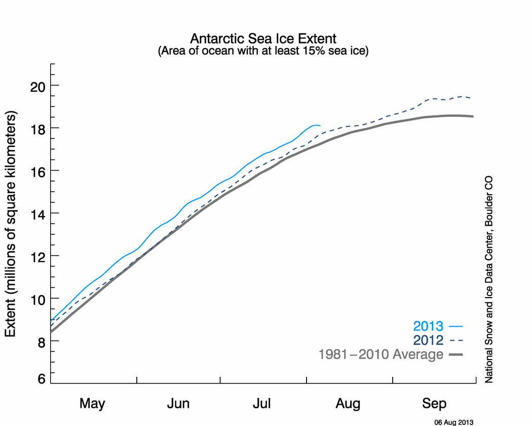


If the theory is correct, the large amount of excess ice should be cooling Antarctica – and that is exactly what we see happening. Temperatures in Antarctica have been running persistently below normal, as seen in the maps below.


There is just one problem with all this. The effect is exactly opposite of what has been predicted by global warming modelers. Antarctic ice is increasing and temperatures are cooling.
Discover more from Watts Up With That?
Subscribe to get the latest posts sent to your email.
Here are other NASA graphic showing Antarctic interior temperatures, that I could quickly find:
http://earthobservatory.nasa.gov/IOTD/view.php?id=7839
http://earthobservatory.nasa.gov/IOTD/view.php?id=8239
http://earthobservatory.nasa.gov/IOTD/view.php?id=8423 (high distortion)
http://earthobservatory.nasa.gov/IOTD/view.php?id=6502 (THERE IT IS!)
Sorry AW — I thought that with all the HTTPs, the post was getting caught in SpamGuard.
Mary Hinge
From Cryosphere Today
Bering Sea – average
Chukchi Sea – average
Arctic Basin – average
E Siberian Sea – average
Laptev Sea – average
Kara Sea – below average
Barents Sea – below average
Greenland Sea area – below Average
Baffin/Newfoundland – slightly below average
Hudson Bay – above average
Beaufont Sea – average
All of the areas that are below average sit in the warm oceanic incoming current. Jet stream patterns also push this soft edge around, sometimes compacting it towards the pole and sometimes pushing it out of the Arctic area. It stands to reason that one may make an educated guess that warm currents and jet stream patterns are keeping these few areas below average. If the entire Arctic area was warm, there would be signs of slower ice in areas that sit in the cold oceanic current. But there isn’t any evidence of this. The Arctic ice area is not one homogeneous area and to think of it as such is simplistic thinking, not scientific thinking.
Even if these other areas that are average or above average show variability from one month to the next, after the ice buildup season is well on its way, sea ice responds to oceanic current temperatures and jet stream patterns far quicker than they do to atmospheric temperature changes. A relative air temperature heat wave just softens the ice along with the warm current the ice sits in, enough so that it can be pushed and shoved into warmer waters or compacted into the cold ice edge. After the ice begins to melt in the Spring, its shape and extent is also much more sensitive to ocean termps and jet stream patterns than it is to day to day atmospheric temps. Many times, the ice doesn’t melt in the Arctic, it is pushed out and melted away from the Arctic. This past melt season experienced strong outward current flow and jet stream forces that sent the ice packing into a tropical vacation, relatively speaking, where it melting away like Frosty the Snowman.
It is far better to understand Arctic graphs by looking at each sea separately. There are lots of similar events in every year where the data (taken from each sea ice area and there are 11 altogether), takes a dip. Arctic sea ice data is noisy. Nothing to worry about.
Steven,
Thanks again for replying and thanks for copying Walt Meier’s mail here (I thoroughly enjoyed the sets of questions he answered here previously).
Sorry if I ask silly questions, I really am a nitwit when it comes to climate science. FYI I consider myself alarmed (not only because of AGW) rather than alarmist.
I think it is safe to say that an ice free North Pole in September would have little impact on the earth’s SW radiation balance, because there is essentially no incoming SW radiation. The sun is only a few degrees above the horizon, and well below the critical angle of air over water.
Would the impact on the climate also be small though? My gut says this Arctic amplification-thing could be stirring things up quite considerably if kept up. Especially if even only 10% of the whole permafrost-methane-clathrate story is true.
No doubt climate modelers have backfitted their theories to match observational evidence. yet we still hear an astonishing myriad of contradictory information from official sources. Antarctica is warming, Antarctica is cooling, ocean currents are warming Antarctica, ocean currents are cooling Antarctica, the WAIS is going to collapse, etc.
I’ll take your word on that, don’t know too much about Antarctica or WAIS (except for the ‘Katabatic’ documentary I mentioned). My interest at the moment goes out to the Arctic.
Does the spectacular swing to the right this past week mean anything? Like another data mistake or something else? I’m not reading anything about it at RC or here or Tamino. One would think both ‘alarmists’ and ‘delayers’ (I don’t like to think in groups) would be on to this thing?
Leon Brozyna (16:34:46) :
Well, no wonder the media’s focus is on the Arctic sea ice. The Antarctic sea ice doesn’t present the same foreboding image. Remember, it’s not about science but image with which to promote the AGW political movement.
Sorry Leon – I disagree – I find it more plausable that the MSM is ‘Selling Advertising Space’ to generate revenue for the shareholders. The Scare message attracts attention and assists with the sale of advertising time. However, some individuals within the MSM are, no doubt, AGW True Believers and will slant stories in that direction in any event and discount contrary data.
Journalists, like politicians, have a public ego and once invested in an idea – can’t stand to see it refuted because it will damage their credibility and hence their livelihoods.
Does anyone have any idea what’s going on here? JAXA seems to show the Arctic freeze as completely stopped for the last week!
http://www.ijis.iarc.uaf.edu/en/home/seaice_extent.htm
“Does the spectacular swing to the right this past week mean anything? Like another data mistake or something else? I’m not reading anything about it at RC or here or Tamino”
At last! Another person who’s noticed it! I’ve been asking questions for a day or so now – it really is quite an anomaly. Surely someone has an idea what’s happenig?
Neven (13:11:46) :
Does the spectacular swing to the right this past week mean anything? Like another data mistake or something else? I’m not reading anything about it at RC or here or Tamino. One would think both ‘alarmists’ and ‘delayers’ (I don’t like to think in groups) would be on to this thing?
Hi Neven, Check out Pamela Gray’s posts on the following thread.
http://wattsupwiththat.com/2008/12/18/the-deadliest-us-natural-hazard-extreme-cold/
Pamela Gray (08:33:14) :
Pamela Gray (08:36:23) :
I think that she has addressed your questions there.
Cheers Graeme (and Pamela) for the info.
No big deal then and not a mistake either. I’m very curious as to what next summer’s melting season will look like. I hope it’s all a natural cycle, though I’m not convinced yet. I think the coming years in the Arctic, more than anything else, could be quite decisive on the general perception of AGW.
Neven,
Actually your questions are among the most thoughtful. I have no idea what the overall future of Polar climate feedbacks will be. This particular feedback (ice albedo) is relatively simple to evaluate in a semi-quantitative fashion, and that is why I chose to write about it.
The WAIS is the West Antarctic Ice Sheet. As far as the dogleg right on the ice graph, it is about to be followed by a dogleg left. The Sea of Okhotsk is a few days late this year, but is currently experiencing extremely cold air temperatures.
http://www.wunderground.com/wundermap/?lat=55.17887&lon=142.47070&zoom=5&type=hyb&units=english&rad=1&rad.num=1&rad.spd=25&rad.opa=70&rad.stm=0&wxsn=1&wxsn.mode=tw&svr=0&cams=0&sat=0&riv=0&mm=0&hur=0&fire=0&tor=0&ndfd=0&pix=0
Arctic Sea Ice: An Engineer’s Question
Why is a ice-free Arctic Ocean a bad thing? No answer for that one, but let me ask another: Which surface reflects the most solar energy, open sea or pack ice?
Before you answer, remember that the sun is NEVER more than 23.5-degrees above the horizon. Solar radiation is going to hit whatever surface exists in the Arctic at an acute (grazing) angle; therefore, 1) the radiation is far from vertical incidence (less heat per unit of surface area); and 2) hitting water at an acute angle means the reflection back into space is much higher than it would be for a near-vertical incidence.
The point is that solar radiation cannot cause polar heating. The heat has to come from somewhere else. Atmospheric and marine currents are the only transport mechanisms available to cause heating or cooling at the poles. The expansion of ice in the Antarctic (where there is no ocean under the ice) would lead to the deduction that marine circulation is the main cause of Arctic ice coverage variations. Why can’t the “experts” figure that out?
Andy (20:18:41) :
I am not a scientist and my understanding is that the AGW models are statistical. My simple question is, what is their degree of certainty? Can anyone point me to where this is stated or published?
The error bands are rather speculative. The best analysis I’ve seen of why the models are not very useful is this one:
A wonderful example (proof?) of the fact that we can’t know is here:
http://www.sciencebits.com/CO2orSolar
where he used IPCC data and shows that even it is is accepted as true, the error band on the aerosols swamps the CO2 impact. You can’t even know the sign of the net human impact, never mind the magnitude.
Never have your precision exceed your accuracy…
George E. Smith (00:22:03) :
Justin, you have to be a little careful here. See what you excerpted about sunlight being reflected by the ice.
George, did you see the link I posted that showed O3 as being down 40% at the poles and it being a significant part of the GHG profile ( 1/3 ). Have you considered what it would mean to heat loss to have 40% less ozone? 13.3% less total GHG effect ought to do something! How does the absorption spectrum of O3 relate to that of water and CO2? You’re much better at figuring this out than I am…
I’d expect that 13% more heat loss at both poles might have something to do with our present frigid weather coming from the poles…
Bill Brown:
The expansion of ice in the Antarctic (where there is no ocean under the ice) would lead to the deduction that marine circulation is the main cause of Arctic ice coverage variations. Why can’t the “experts” figure that out?
Because the ‘experts’ know that the Antarctic sea ice which grows and melts every year is indeed over the ocean!
Pamela Gray (12:49:52) :
Hi Pamela,
I take your point about regional variations in the Arctic but to get a holistic picture you have to use values instead of a basic description. The warm ocean current point is valid, you have to remember these are anomolous variations so the immediate inference is that the ocean currents are warmer than usual. I would also agree to get a better understanding you need to look at areas in isolation, this is just common sense, but you can’t use that as an excuse to ignore the fact that the Arctic ice sheet is now at its lowest extent recorded for this time of year and all indications are for low ice extent next summer.
Do you remember the earlier posts about the ‘unprecedented freezing’, Anthony mentioned it at least four times using this as the reference http://www.ijis.iarc.uaf.edu/seaice/extent/AMSRE_Sea_Ice_Extent.png.
He obviously thinks it is very important (it is now a permanent link on the right)
Does anyone knows a good site for Arctic ice thickness? A couple of days ago it was in the newspaper that the arctic has never been that thin. I searched to find measurements on that, but i don’t find it.
Mary, once again I have to restate that the Arctic ice sheet is not one thing. It is several. The extent of the sheet is average, above average, or below average depending on the area. It currently is all three. So you cannot say accurately that, “…the ice sheet is now at its lowest extent recorded for this time of year”. The overall extent graph is not an accurate measure of ice extent because this kind of graph consistently hides the fact that the Arctic sheet behaves differently depending on specific areas. You would be just as wrong if you decided to average Washington, Oregon, and California into one averaged temperature data set. It is misleading to say the least, and meant to drive an agenda at worst.
Dave, to date, the only thickness measurements are done by an old satellite (Envisat) that leaves a fairly large hole near the pole. Those measurements demonstrated that the Arctic area thinned between 2002-2008 but not in all areas (see above comments on Arctic areas). A new satellite is being prepared that will do a better job:
CryoSat-2 is the first radar satellite specifically designed to measure ice thickness. It will do this with greater resolution than is possible with Envisat and so will give scientists a much more detailed picture of what is happening to ice in the Arctic. CryoSat-2 is being prepared for launch at the end of 2009.
http://www.sciencedaily.com/releases/2008/10/081027200309.htm
Other studies in the Antarctic demonstrate thinning in some areas and thickening in other areas. The theory was that snow fall would increase thickness. But that didn’t happen in the thinned areas in spite of snow fall. I am beginning to see more scientists talking about currents and wind patterns influencing ice extent, thickness, etc. and less talk about temperature or soot.
Bill Brown,
You might want to consider that Antarctica currently has sea ice at close to 60 degrees latitude. The sun is actually at an angle in excess of 50 degrees above the horizon right now at those locations, so the albedo is quite important in calculating the SW energy balance.
So if you think it is such a bad idea to use a mean of the arctic ice extent why didn’t you express this opinion during one of the many posts that Anthony used the mean ice extent chart I am refering to? This post is when Anthony started using it as a permanent side bar link http://wattsupwiththat.com/2008/10/13/arctic-sea-ice-continues-to-rebound-quick-link-graphic-added/#comments and this is your post from the thread For long range planning (a must for farmers who grow just about anything), the Arctic is a pretty good marker. The trend, regardless of any kind of average, is that temps are cooling through each season. You don’t say anything about using a mean being ….It is misleading to say the least, and meant to drive an agenda at worst. NONE of the posters said using this graph was misleading.
Why do you think it is now misleading/ agenda driving now when it wasn’t then? As I said before Anthony used this fastest freezing line using the same graphic FOUR times, do you think he is misleading or driving an agenda?
Pamela,
I agree with you that the overall extent graph doesn’t tell the whole story, but does that mean it’s meaningless? I think the analogy you mention about averaging temperatures in Washington, Oregon and California is flawed in the sense that the Arctic regions are interconnected and together form a huge ice mass at the height of winter. Besides it’s not about an average, but an accumulation of the ice extent of all Arctic regions. Your analogy would seem to pertain more to the averaging of Arctic and Antarctic ice (ie saying that it’s alright for the Arctic to lose more and more ice every year because the same amount of ice is growing on Antarctica) , which in my view is pretty useless.
Anyway, the whole science surrounding the Arctic ice extent and why there’s a downward trend etc. is way above my head, so all I have is a few of those graphs to look at, and the JAXA one looks prettiest. 😉
I found the swing to the right rather peculiar when compared to previous years and thought it might be a glitch of some sort. It wasn’t and the swing isn’t that peculiar either, or else people would be all over it. Whether ice extent is at an all-time (recorded) low yesterday or today is iirelevant and doesn’t mean a thing. It’s what happens in summer that counts. We’ll just have to wait and see.
Pamela Gray (08:18:53) :
Mary, once again I have to restate that the Arctic ice sheet is not one thing. It is several. The extent of the sheet is average, above average, or below average depending on the area. It currently is all three.
As I’ve stated before there is currently no region showing extent above average and several regions showing below average.
So you cannot say accurately that, “…the ice sheet is now at its lowest extent recorded for this time of year”. The overall extent graph is not an accurate measure of ice extent because this kind of graph consistently hides the fact that the Arctic sheet behaves differently depending on specific areas.
Of course you can, sure different parts of the ice sheet can behave differently, I prefer area for the very reason that winds and currents can change the extent. Many who post here are quite happy with the overall statistic when it suits their agenda. In the present case it’s even more relevant because most of the regions have maxed out their extent and have no more possible growth, we’re left with the position of the ice sheet as it interacts with the Atlantic and Pacific oceans.
A week or two ago the ASMR-E sea ice extent was equal to or greater than any of the past 6 years. Now it is less than all of the past 6 years. This is the result of the 2008 line going horizontal for that period of time. In other words there has been no change in sea ice extent during that time? Watts up with that?
David Segesta (12:10:23) :
A week or two ago the ASMR-E sea ice extent was equal to or greater than any of the past 6 years. Now it is less than all of the past 6 years. This is the result of the 2008 line going horizontal for that period of time. In other words there has been no change in sea ice extent during that time? Watts up with that?
All the easy ice froze as it usually does at this time of year which is why there’s not much spread in extent between the various year’s data. It doesn’t take much of a swing to go from greatest to least extent, a faster growth in one part of the basin at this time of year will reach it’s limits and eventually all the year’s data will be close. The next phase of growth to a maximum in Feb/Mar depends of growth into the Atlantic and Pacific and that is rather slow at present.
Here’s the last 10 days data, it hasn’t been horizontal as you put it:
12,11,2008,11678594
12,12,2008,11681563
12,13,2008,11662813
12,14,2008,11640625
12,15,2008,11682813
12,16,2008,11731563
12,17,2008,11703594
12,18,2008,11687969
12,19,2008,11706719
12,20,2008,11727188
12,21,2008,11775938
Here’s previous data for today’s date:
12,21,2007,11824219
12,21,2006,11857031
12,21,2005,11827031
12,21,2004,12153438
12,21,2003,12316406
12,21,2002,12151094
It’s been exceptionally warm across the north Atlantic and north Pacific. This is where ice is failing to form – http://ds.data.jma.go.jp/tcc/tcc/products/climate/synop.html . Indeed the whole NH has been running very warm in recent months http://www.ncdc.noaa.gov/img/climate/research/2008/nov/lo-hem-nov-pg.gif.
The Arctic Ice is in big trouble – nearly all old ice gone and new ice struggling to form.