 From the University of Utah, an argument that makes you wonder “what started it 4000 years ago”? Looking at another similar study, Joltin Joe Romm called that study Bombshell: Study Ties Epic California Drought, ‘Frigid East’ To Manmade Climate Change
While they focus on the recent winter as being an example of this errant jet stream pattern and persistent ridges, they completely ignore an almost identical pattern in the winters of 1977/78 before global warming was even a funding twinkle in James Hansen’s eye.
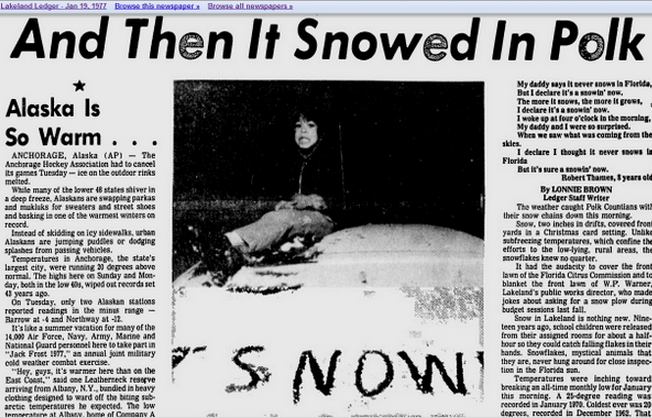
In 1977, a nearly identical pattern set up with warmth in Alaska, drought in California, and cold in Florida. Arctic sea ice was near a peak at the time. (h/t Steve Goddard)
Warm US West, cold East: A 4,000-year pattern
Global warming may bring more curvy jet streams during winter
SALT LAKE CITY, April 16, 2014 – Last winter’s curvy jet stream pattern brought mild temperatures to western North America and harsh cold to the East. A University of Utah-led study shows that pattern became more pronounced 4,000 years ago, and suggests it may worsen as Earth’s climate warms.
“If this trend continues, it could contribute to more extreme winter weather events in North America, as experienced this year with warm conditions in California and Alaska and intrusion of cold Arctic air across the eastern USA,” says geochemist Gabe Bowen, senior author of the study.
The study was published online April 16 by the journal Nature Communications.
“A sinuous or curvy winter jet stream means unusual warmth in the West, drought conditions in part of the West, and abnormally cold winters in the East and Southeast,” adds Bowen, an associate professor of geology and geophysics at the University of Utah. “We saw a good example of extreme wintertime climate that largely fit that pattern this past winter,” although in the typical pattern California often is wetter.
It is not new for scientists to forecast that the current warming of Earth’s climate due to carbon dioxide, methane and other “greenhouse” gases already has led to increased weather extremes and will continue to do so.
The new study shows the jet stream pattern that brings North American wintertime weather extremes is millennia old – “a longstanding and persistent pattern of climate variability,” Bowen says. Yet it also suggests global warming may enhance the pattern so there will be more frequent or more severe winter weather extremes or both.
“This is one more reason why we may have more winter extremes in North America, as well as something of a model for what those extremes may look like,” Bowen says. Human-caused climate change is reducing equator-to-pole temperature differences; the atmosphere is warming more at the poles than at the equator. Based on what happened in past millennia, that could make a curvy jet stream even more frequent and-or intense than it is now, he says.
Bowen and his co-authors analyzed previously published data on oxygen isotope ratios in lake sediment cores and cave deposits from sites in the eastern and western United States and Canada. Those isotopes were deposited in ancient rainfall and incorporated into calcium carbonate. They reveal jet stream directions during the past 8,000 years, a geological time known as middle and late stages of the Holocene Epoch.
Next, the researchers did computer modeling or simulations of jet stream patterns – both curvy and more direct west to east – to show how changes in those patterns can explain changes in the isotope ratios left by rainfall in the old lake and cave deposits.
They found that the jet stream pattern – known technically as the Pacific North American teleconnection – shifted to a generally more “positive phase” – meaning a curvy jet stream – over a 500-year period starting about 4,000 years ago. In addition to this millennial-scale change in jet stream patterns, they also noted a cycle in which increases in the sun’s intensity every 200 years make the jet stream flatter.
Bowen conducted the study with Zhongfang Liu of Tianjin Normal University in China, Kei Yoshimura of the University of Tokyo, Nikolaus Buenning of the University of Southern California, Camille Risi of the French National Center for Scientific Research, Jeffrey Welker of the University of Alaska at Anchorage, and Fasong Yuan of Cleveland State University.
The study was funded by the National Science Foundation, National Natural Science Foundation of China, Japan Society for the Promotion of Science and a joint program by the society and Japan’s Ministry of Education, Culture, Sports, Science and Technology: the Program for Risk Information on Climate Change.
 |
||||
Sinuous Jet Stream Brings Winter Weather Extremes
The Pacific North American teleconnection, or PNA, “is a pattern of climate variability” with positive and negative phases, Bowen says.
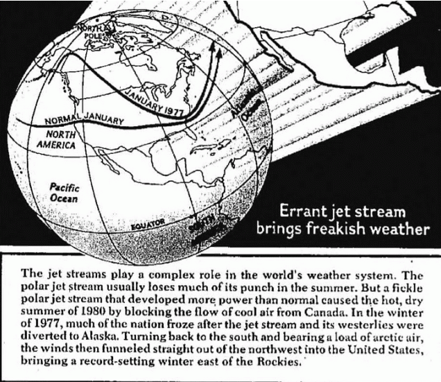
“In periods of positive PNA, the jet stream is very sinuous. As it comes in from Hawaii and the Pacific, it tends to rocket up past British Columbia to the Yukon and Alaska, and then it plunges down over the Canadian plains and into the eastern United States. The main effect in terms of weather is that we tend to have cold winter weather throughout most of the eastern U.S. You have a freight car of arctic air that pushes down there.”
Bowen says that when the jet stream is curvy, “the West tends to have mild, relatively warm winters, and Pacific storms tend to occur farther north. So in Northern California, the Pacific Northwest and parts of western interior, it tends to be relatively dry, but tends to be quite wet and unusually warm in northwest Canada and Alaska.”
This past winter, there were times of a strongly curving jet stream, and times when the Pacific North American teleconnection was in its negative phase, which means “the jet stream is flat, mostly west-to-east oriented,” and sometimes split, Bowen says. In years when the jet stream pattern is more flat than curvy, “we tend to have strong storms in Northern California and Oregon. That moisture makes it into the western interior. The eastern U.S. is not affected by arctic air, so it tends to have milder winter temperatures.”
The jet stream pattern – whether curvy or flat – has its greatest effects in winter and less impact on summer weather, Bowen says. The curvy pattern is enhanced by another climate phenomenon, the El Nino-Southern Oscillation, which sends a pool of warm water eastward to the eastern Pacific and affects climate worldwide.
Traces of Ancient Rains Reveal Which Way the Wind Blew
Over the millennia, oxygen in ancient rain water was incorporated into calcium carbonate deposited in cave and lake sediments. The ratio of rare, heavy oxygen-18 to the common isotope oxygen-16 in the calcium carbonate tells geochemists whether clouds that carried the rain were moving generally north or south during a given time.
Previous research determined the dates and oxygen isotope ratios for sediments in the new study, allowing Bowen and colleagues to use the ratios to tell if the jet stream was curvy or flat at various times during the past 8,000 years.
Bowen says air flowing over the Pacific picks up water from the ocean. As a curvy jet stream carries clouds north toward Alaska, the air cools and some of the water falls out as rain, with greater proportions of heavier oxygen-18 falling, thus raising the oxygen-18-to-16 ratio in rain and certain sediments in western North America. Then the jet stream curves south over the middle of the continent, and the water vapor, already depleted in oxygen-18, falls in the East as rain with lower oxygen-18-to-16 ratios.
When the jet stream is flat and moving east-to-west, oxygen-18 in rain is still elevated in the West and depleted in the East, but the difference is much less than when the jet stream is curvy.
By examining oxygen isotope ratios in lake and cave sediments in the West and East, Bowen and colleagues showed that a flatter jet stream pattern prevailed from about 8,000 to 4,000 years ago in North America, but then, over only 500 years, the pattern shifted so that curvy jet streams became more frequent or severe or both. The method can’t distinguish frequency from severity.
The new study is based mainly on isotope ratios at Buckeye Creek Cave, W. Va.; Lake Grinell, N.J.; Oregon Caves National Monument; and Lake Jellybean, Yukon.
Additional data supporting increasing curviness of the jet stream over recent millennia came from seven other sites: Crawford Lake, Ontario; Castor Lake, Wash.; Little Salt Spring, Fla.; Estancia Lake, N.M.; Crevice Lake, Mont.; and Dog and Felker lakes, British Columbia. Some sites provided oxygen isotope data; others showed changes in weather patterns based on tree ring growth or spring deposits.
Simulating the Jet Stream
As a test of what the cave and lake sediments revealed, Bowen’s team did computer simulations of climate using software that takes isotopes into account.
Simulations of climate and oxygen isotope changes in the Middle Holocene and today resemble, respectively, today’s flat and curvy jet stream patterns, supporting the switch toward increasing jet stream sinuosity 4,000 years ago.
Why did the trend start then?
“It was a when seasonality becomes weaker,” Bowen says. The Northern Hemisphere was closer to the sun during the summer 8,000 years ago than it was 4,000 years ago or is now due to a 20,000-year cycle in Earth’s orbit. He envisions a tipping point 4,000 years ago when weakening summer sunlight reduced the equator-to-pole temperature difference and, along with an intensifying El Nino climate pattern, pushed the jet stream toward greater curviness.
Manmade CO2 has become the “new witch” of the 21st Century…blame every change in the weather on the new witch…the irony is that burning of the old witches used to release more CO2… https://www.youtube.com/watch?feature=player_detailpage&v=yp_l5ntikaU
As climate warms there will be more severe winters?
“If this trend continues, it could contribute to more extreme winter weather events in North America, as experienced this year with warm conditions in California and Alaska and intrusion of cold Arctic air across the eastern USA,” says geochemist Gabe Bowen, senior author of the study.”
Are you sure this article wasn’t printed in “The Onion?”
Curvy ‘meridional’ jets are inevitably associated with longer lines of air mass mixing, greater global cloudiness, less solar energy into the oceans and COOLING.
All past such periods were during colder epochs such as the LIA.
“Nuts”(and any Meteorologist knows it).
“It is not new for scientists to forecast that the current warming of Earth’s climate due to carbon dioxide, methane and other “greenhouse” gases already has led to increased weather extremes and will continue to do so.”
That sounds like a hindcast to me. It also sounds like a bunch of scientists are using a flawed consensus to assert an unprovable link. But who am I to notice.
The curvy jet stream pattern is what we would expect in a negative Pacific Decadal Oscillation plus La NIna situation. The cool eastern Pacific intensifies the high pressure system blocking westerlies and creating the warm and dry American southwest. El Ninos and a positive PDO weaken that High. They need to test natural cycles and the frequency of “curvy jet streams before they can connect any CO2 contribution
“the atmosphere is warming more at the poles than at the equator. Based on what happened in past millennia, that could make a curvy jet stream even more frequent and-or intense than it is now, he says.”
That is because more curvy jet stream tracks carry more warm air closer to the poles.
It is well established that fast zonal flows around the poles allow the poles to get colder because less warm air can flow in.
As usual they reverse cause and effect to try and prop up a failed theory.
More curvy jets arise as a result of a change in the gradient of tropopause height between equator and poles.
A quiet sun results in more stratospheric ozone above the poles which warms the stratosphere, pushes the tropopause down at the poles and forces surges of cold air equatorward.
It is no coincidence that the polar ozone holes are no longer growing and may be shrinking and that ozone amounts above 45km INCREASED from 2004 to 2007 despite (more likely because of) the quiet sun
Global warming may bring more curvy jet streams during winter
It’s always may or could.
Global warming may bring more hemorrhoids and constipation
“suggests”…. “may”….. “if”…… “could”……
IOW, they don’t have a freakin’ clue about anything other than how to generate headlines.
“A sinuous or curvy winter jet stream means unusual warmth in the West, drought conditions in part of the West, and abnormally cold winters in the East and Southeast,” adds Bowen, an associate professor of geology and geophysics at the University of Utah. “We saw a good example of extreme wintertime climate that largely fit that pattern this past winter,” although in the typical pattern California often is wetter.
Ouch, it hurts my brain; I couldn’t read past this paragraph for the fear of being infected with stupidity.
So, they’ve gone from attempting to explain “The Pause” to completely side-stepping it. Global Warming is so yesterday. Magical manmade CO2 can do anything except cause “normal” weather, and even that I’m not sure of. Perhaps “abnormally normal” weather is in the climate cards.
As a retired Canadian semi-truck driver, my 70-year-old husband remembers having to help start trucks and forklifts in the southwestern U.S. during the various cold periods over the years. He keeps saying “Look at the jet stream” to figure out the weather patterns.
He dropped out of school at fifteen to go to work, but that doesn’t mean he stopped learning and paying attention.
It is the compulsive need of the AGW believers to write post hoc ‘science’ papers attributing any given weather event to CO2 that is most entertaining. When an academic writes this sort of scholck, it is even more entertaining when a member of the academic community writes these faux papers because the mixture of historical illiteracy and ignorant credulity contrasts so sharply with the educational achievements of the author or authors.
This pattern raises the logical question: If the authors are so bright and enlightened, why do they demonstrate no ability to fact check or corroborate their work before publishing it? I htink it is for the same reason Lew and pals publish their dreck with such confidence: they believe their community is very likely to circle the wagons and defend them than to call them out.
Sudden increases in temperature in winter above the Arctic Circle occur in the stratosphere due to changes in solar activity. This results inhibition of the polar vortex. Jetstream 250 hPa can not access the polar circle when the vortex is strong. Only weakening of the polar vortex allows the inflow of warm air over the Arctic Circle.
You can see it perfectly on animation at the South Pole.
Startosphere about 20 km.
http://www.cpc.ncep.noaa.gov/products/intraseasonal/temp50anim.gif
Can be seen the weakening of the vortex in the region of South America.
http://earth.nullschool.net/#current/wind/isobaric/70hPa/orthographic=28.89,-89.16,419
I wish to call your attention to another study released today by NASA Science News “Unexpected Teleconnections in Noctilucent Clouds.”
science.nasa.gov/science-news/science-at-nasa/2014/16apr_teleconnections/ in which it was reported “New data from NASA’s AIM spacecraft have revealed “teleconnections” in Earth’s atmosphere that stretch all the way from the North Pole to the South Pole and back again, linking weather and climate more closely than simple geography would suggest.
For example, says Cora Randall, AIM science team member and Chair of the Dept. of Atmospheric and Oceanic Sciences at the University of Colorado, “we have found that the winter air temperature in Indianapolis, Indiana, is well correlated with the frequency of noctilucent clouds over Antarctica.”
Noctilucent clouds, or “NLCs,” are Earth’s highest clouds. They form at the edge of space 83 km above our planet’s polar regions in a layer of the atmosphere called the mesosphere. Seeded by “meteor smoke,” NLCs are made of tiny ice crystals that glow electric blue when sunlight lances through their cloud-tops. ”
This January, a time of year when southern NLCs are usually abundant, the AIM spacecraft observed a sudden and unexpected decline in the clouds. Interestingly, about two weeks earlier, winds in the Arctic stratosphere were strongly perturbed, leading to a distorted polar vortex. ”
They present a plot over a period of one and a half months showing this correlation.
Note: Polar vortex & cold snap before decline in NLCs.
Will be interesting to see if this pattern repeats next year.
In reply to:
DR says:
April 15, 2014 at 6:38 pm
Did they ever figure out the cloud problem? How about why the surface warming faster than the mid-troposphere (the ubiquitous “hot spot”)?
William:
The answer to your two questions is no: 1) the IPCC still ignores the fact that cloud cover in the tropics increases or decreases to resist forcing (negative feedback, confirmed by Lindzen and Choi by top of the atmosphere radiation measurements vs ocean temperature change for three month periods) rather amplifies forcing and 2) the IPCC still ignores the fact that the predicted tropical troposphere hot spot is not observed.
The oceans’ evaporation problem needs to be added to your list. The IPCC’s general circulation models have assumed ocean evaporation increases 2.5%/C of ocean warming compared to 10.2%/C measured by satellite or 6%/C of ocean warming based on theoretical calculations (See links for details). Table 1 shows how an increase in the rate of evaporation affects the expected planetary temperature rise for a doubling of atmospheric CO2, based on the calculation of the guest contributor. The nominal IPCC estimate of 3.2C drops to 0.73C with neutral cloud feedback.
http://climateclash.com/improved-simple-climate-sensitivity-model/
http://climateclash.com/files/2011/02/PetT1b.jpg
Table 1 – Surface Temperature Increases for 2xCO2 with feedbacks (Min/Nominal/Max)
1) IPCC(2007) with constant evaporation and Ts =3010_______ 2.00/3.20/4.5 C
2) IPCC(2007) with constant evaporation and Ts =2645_______ 1.60/2.29/2.89 C
3) Same as above with 2.5%/C evaporation change rate______ 1.25/1.33/1.58 C
4) Same as above with 6%/C evaporation change rate________ 0.69/0.84/0.97 C
5) Same as above with no (William: Neutral) cloud feedback __0.61/0.73/0.82 C
6) Same as above with negative cloud feedback____________0.55/0.64/0.71 C
Oceans Evaporation Problem
http://wattsupwiththat.com/2014/04/15/major-errors-apparent-in-climate-model-evaporation-estimates/
“The physics of evaporation has complications related to what happens at the water / air interface such as wind speed and wave action. However if these factors remain constant, how evaporation changes with temperature and humidity can be estimated with well-known equations based on how water vapor pressure varies with temperature. For example, at a typical ocean temperature of 17 C, it should increase about 6.5% / C if the water vapor increases to maintain relative humidity, that the climate models indicate. If the surface air tracks the water within 2 C, the rate varies from 6.2% to 6.9% / C. Data over oceans by Wentz et, al (2007) report values of about 6% / C.
But the complex computer climate models (William: used by the IPCC to make scary claims, general circulation models, GCMs) show averages of only about 2.5% / C. There are no claims of reduced wind speeds (William: The IPCC assumes wind speeds are reduced when the planet warms in the tropics however wind speeds have been shown to increase when the tropics warms due to differential temperatures between cloudy and non-cloudy regions) or wave action or increased relative humidity to explain this. However many papers on the subject claim that the available energy is limiting evaporation in these models.”
Satellite data shows evaporation of the tropical ocean increases 10.5%/C of ocean warming which is higher than the calculated 6.5%/C of ocean warming as the wind speed over the ocean increases when it warms.
http://www.drroyspencer.com/2014/04/ssmi-global-ocean-product-update-increasing-clouds-with-a-chance-of-cooling/
“SSM/I Global Ocean Product Update: Increasing clouds with a chance of cooling
The water vapor variations lag the SST variations by an average of one month. A regression relationship reveals an average 10.2% increase in vapor per deg. C increase in SST. This is larger than the theoretically-expected value of 6.5% to 7% increase, a discrepancy which can be interpreted in different ways (more evaporative cooling of the ocean stabilizing the climate, or more water vapor feedback destabilizing the climate — take your pick).”
P.S. Idso uses 10 different natural phenomena where a known forcing change caused by different natural phenomenon is used to calculate the planet’s sensitivity to a change in forcing. Idso’s best estimate for the warming for a doubling of atmospheric CO2 from that calculation is 0.4C.
http://www.mitosyfraudes.org/idso98.pdf
There is no way that the viscosity or density of air could be sufficiently affected by a few hundred parts per million of CO₂ to cause the jet stream to move southward, northward, upward or downward. This pseudoscience is just more of WHAT LYSENKO SPAWNED.
Phenomena that occur in winter in the stratosphere in the polar vortex has nothing to do with global warming because warm in the zone of the ozone moves from the top to bottom.
http://www.cpc.ncep.noaa.gov/products/stratosphere/strat-trop/gif_files/time_pres_TEMP_MEAN_JFM_NH_2014.gif
I was unable to cut and paste a paragraph from the article. Is anyone else having similar difficulties?
[Note that the “image graphic” does contain words, but they are not text. They are pixels just like any other graphic scanned from the original cartoon of the winds. Is that what you are trying to cut-and-paste? Mod]
and suggests it may…
..and I stopped reading
I advise you to check the data below, so do not get to cheat.
http://www.cpc.ncep.noaa.gov/products/stratosphere/
http://www.cpc.ncep.noaa.gov/products/precip/CWlink/daily_ao_index/ao.shtml
I am experiencing difficulties in cutting and pasting a paragraph from the article. Is anyone else experiencing problems?
The Lewiston Journal’s and other medias “report” on the so called “freak weather” was a blatant attempt by denialisticismists to sabotage the real truth reported by present day climate scientologists who deserve better than to be bombarded with so called facts
(do i really need to add a sarc tag?)
“The study was funded by the National Science Foundation, National Natural Science Foundation of China, Japan Society for the Promotion of Science and a joint program by the society and Japan’s Ministry of Education, Culture, Sports, Science and Technology: the Program for Risk Information on Climate Change.”
Seems like their questionable research was a nice little earner from six funding bodies.
Ever notice how no one even considers the possibility that the Holocene might be nearing its end?
Virtually every one of these “studies” rambles on and on about millennial or shorter patterns without one single word about the already half-precession cycle old Holocene. It’s like climate would just continue on and on like the present if it were not for us.
Fascinatingly, if they are right about CO2, would it not be the single most important atmospheric ingredient for fighting off glacial inception? Ever consider that?