Guest essay by Larry Hamlin
With all the climate alarmist hype about Hurricane Helene (and yet more coming with Milton) it seems appropriate to introduced everyone to the Year 1916 Major Hurricane Number 4 that preceded the year 2024 Hurricane Helene visit to Asheville with the headlines shown below and discussed in the WUWT article here.

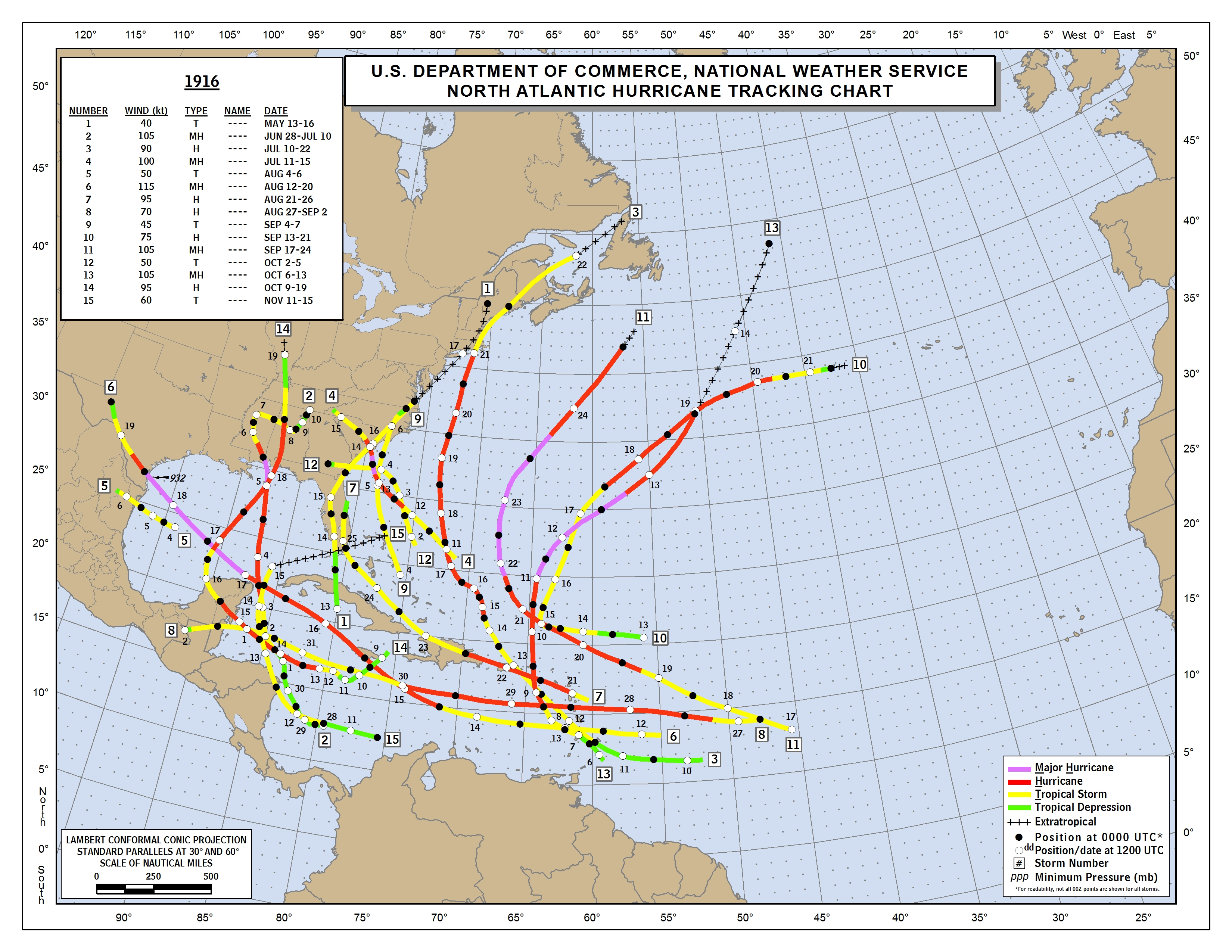
NOAA’s 1916 Atlantic Hurricane season outcome data is presented below and found here.

The 1916 Major Hurricane Asheville culprit is Number 4 on the list at a time when names were not given to hurricanes and there were no satellites, hurricane hunter aircraft or long-range weather radar systems available to identify and track storms.
There were 15 numbered Atlantic storms in 1916 even though there easily could have been many more that were never observed during this season because of observation inadequacies compared to today’s available technology.
The Map below is expanded to better show the origin and path of Major Hurricane Number 4 which starts in about the middle of the Map with a square with the number 4 identifying this event.

Major Hurricane Number 4 moves onto the coastline of South Carolina and then finishes by moving into North Carolina and Tennessee as it moved rapidly over the period July 11 to July 15 and ended as a tropical storm and depression in the Asheville area.
Colorado State University’s comprehensive Northern Hemisphere Tropical Cyclone Activity data identify the following pertinent information regarding the 1916 Atlantic hurricane year metrics using their extensive basin archives data base information.
The 1916 Atlantic season had 10 hurricanes as shown below compared to 9 hurricanes so far in this year’s 2024 season.

The 1916 Atlantic season had 5 major hurricanes as shown below compared to 4 major hurricanes (including Milton) so far in this year’s 2024 season.

The 1916 Atlantic season had a total ACE component of 144 as shown below compared to the 2024 season total 115.6 as of October 7, 2024.
The Atlantic Season 30-year ACE average (1991 – 2020) is at a value of 122.5 so the year 1916 was an above average ACE hurricane year.

In 1916 3 major hurricanes crossed into the contiguous U.S. land region with 2 additional other hurricanes making land strikes as well thus totaling 5 inland hurricane strikes in all.
In 1916 the deepest land strike into the U.S. was Hurricane Number 14 which came up from the Gulf of Mexico and reached into and across the states of Florida, Alabama, Tennessee, Kentucky and ended in Illinois as shown on the map.
Apparently the “hurricanes” of 1916 did not know that future “climate change” was needed to allow hurricanes to reach that high into the U.S.
If politically driven climate alarmist propagandists had been around 108 years ago it seems certain that the year 1916 outcomes would also have been characterized as being a clear “sign” that hurricanes are getting worse because of “climate change”.
Story tip – extremism news
LABOUR CAVE IN TO EXTINCTION REBELLION’S DEMANDS TO SACK LORD WALNEY
https://order-order.com/2024/10/08/labour-cave-in-to-extinction-rebellions-demands-to-sack-lord-walney/
Bill McKibben thinks that tropical storms and hurricanes are climate, not weather, phenomena.
The UN’s World Meteorological Organization renamed “climate” to now mean 30 years of weather.
Even 30 years is completely subjective.
Good information.
What about Agnes in 1972? I recall going to my grandparents house in Forty Fort PA (Wilkes-Barre) the following year. The place was wiped out. We went into a house in Kingston where the water line was mid way up on the second floor.
I was in Pittsburgh then at CMU. I knew about Agnes, but wasn’t paying much attention. One evening when I was bicycling home in the second day of rain it occurred to me that it might still be Agnes, and discovered that it had stalled in the Wilkes Barre area, in a different watershed.
The Allegheny and Monongahela Rivers flooded the riverside areas and the “point” where the Fort Pitt museum had recently been redone. Loose barges were floating down the river destroying much in their paths. The casks of bourbon weren’t so destructive and I assume several people ignored official warnings about bacterial contamination to salvage some.
See https://www.youtube.com/watch?v=OSkjpjKTOFo&t=15s for an extended news program before the crest. Later in the program there are descriptions of damage elsewhere in the state, and at 20m23s is a review of the much worse 1936 flood is generally called the All New England Flood. That event triggered building many flood control dams throughout the northeast.
I was thinking about that the other day. My dad grew up in Wilkes-Barre and we used to go up there every summer on vacation when we were kids. i remember going through W-B after the flood and seeing a bridge over the Susquehanna river completely washed away. There was also Camille in 1969 that did the same thing to western and central Virginia.
Milton is moving away from the Yucatan and growing in strength. At this point it is a very dangerous hurricane and will remain so when it reaches Tampa Bay.
Pressure in the eye now 972 hPa.
Growing size, not strength. At the Cat 5 peak approaching Yucatán Milton eye pressure was 897! and estimated eye wall wind speed was 180. (Lowest ever for an Atlantic hurricane was Wilma when a Cat 5 at 888.) I lived through Wilma. When it hit Florida due west of me it had weakened to a high Cat 3. Wilma’s eye expanded to about 55 miles as it crossed the Everglades, so that all of Broward County essentially experienced low Cat 3 eye wall conditions. It was real bad for a long time.
Current models have Milton’s eye hitting disastrously at or just above the Tampa Bay entrance as a mid to high Cat 3. The larger it gets, the weaker it will get but the more storm surge it will push into the Bay. Absolute worst case scenario.
Here in Fort Lauderdale, NHC currently says we only have a 40% chance of seeing any tropical storm force winds. Probably some gusts, no different than a typical thunderstorm. I have not yet brought in the two balconiy furniture sets (cushions and plants are already in). Will wait to see tomorrow noonish. The east teak is very heavy and sturdy, the west faux loose wicker (plastic coated steel) has a negligible wind cross section. Bringing it all in is a PITA, so only worth doing if hurricane chances are medium to high. Last time was Irma—definitely needed everything off the balconies then. Ours was the only unit facing east on our 12th floor that did not take any damage from the weak tornado that Irma spun thru.
5:30 PM EDT update has it at 905 mb and 165 mph. May change by 8:00 PM, though.
Brilliant, Bravo once again for accurate information.
Asheville last took a direct hit in 1916. Tampa Bay last took a direct hit in 1921. Asheville took, and Tampa Bay will take, direct hits in 2024. Category 4 remenants and likely high end Category 3, respectively. We will know tomorrow night.
Difference is, Asheville did not evacuate while Tampa Bay is. In both cases flooding (mountain rain fall and storm surge, respectively) was/is certain.
Vermont went through similar in 1927. After which, the State built flood control dams to slow the course of heavy rains down the steep hillsides and valleys. Just like the TVA.
Where is a good source for old newspaper scans? I love the 1st photo of the News and Observer.
I use genealogybank.com but there is also newspapers.com both have large collections of historic digitized newspapers
In the 1970’s, the TVA proposed a number of flood control dams in the Broad French River watershed. They were cancelled by local opposition from a growing environmental movement. Wild rivers are beautiful, until they take you house away.