From NOT A LOT OF PEOPLE KNOW THAT
By Paul Homewood
We have now got most of the data in for Hurricane Helene, so it is time for a proper recap:

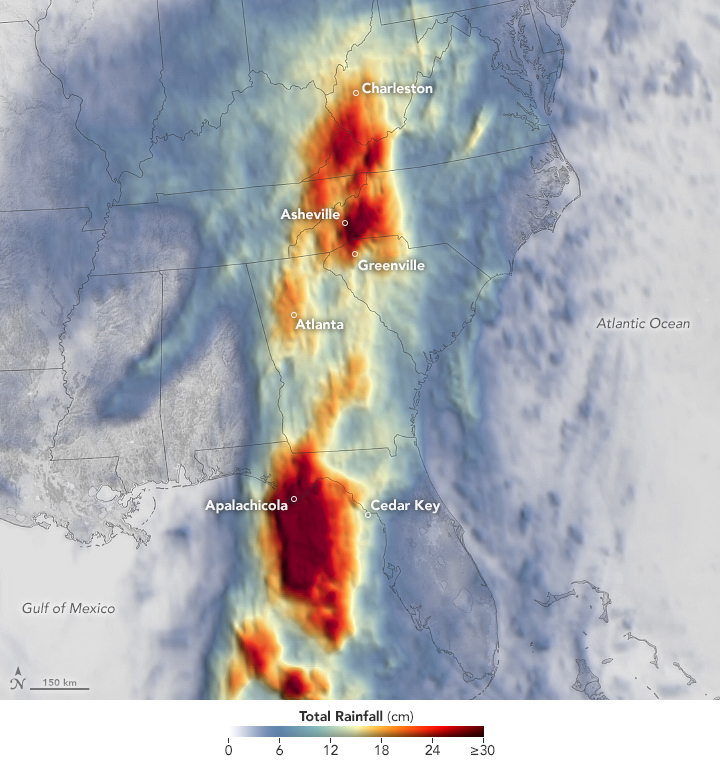
Hurricane Helene intensified as it approached Florida’s Big Bend in fall 2024, ultimately making landfall as a Category 4 storm at 11:10 p.m. Eastern Time on September 27. Even while its center was still over the Gulf of Mexico, the hurricane had begun producing devastating outcomes on land. A predecessor rain event and then the main storm system brought heavy precipitation to southern Appalachia starting on September 25. Deadly and destructive flooding occurred as a result in eastern Tennessee, western Virginia, and North Carolina, among other areas.
This map shows rainfall accumulation over the three-day period ending at 7:59 p.m. Eastern Time (23:59 Universal Time) on September 27, 2024. These data are remotely sensed estimates that come from IMERG (the Integrated Multi-Satellite Retrievals for GPM), a product of the GPM (Global Precipitation Measurement) mission, and may differ from ground-based measurements. For instance, IMERG data are averaged across each pixel, meaning that rain-gauge measurements within a given pixel can be significantly higher or lower than the average.
In Asheville, North Carolina, a total of 13.98 inches (35.52 centimeters) of rain fell from September 25 to 27, according to National Weather Service records. The storm swamped neighborhoods, damaged roads, caused landslides, knocked out electricity and cell service, and forced many residents to evacuate to temporary shelters. Record flood crests were observed on multiple rivers in the state. Flooding was widespread across the southern Appalachians; preliminary rainfall totals neared or exceeded 10 inches (25 centimeters) in parts of Georgia, North Carolina, South Carolina, Tennessee, and Virginia.
On the coast of Florida, the heaviest rainfall was concentrated west of the storm’s center, in and around the town of Apalachicola. For hurricanes in the gulf, heavy rainfall typically occurs east of the storm’s center, where counterclockwise rotation brings in the most moisture from the water body. In the case of Helene, a frontal boundary over the Florida Panhandle interacted with the circulation to concentrate the highest totals west of the center, noted Steve Lang, a research meteorologist at NASA’s Goddard Space Flight Center.
Parts of the Florida coast receiving less rain were not spared from flooding, however. Several Gulf Coast cities and towns, including Cedar Key and Tampa, were affected by storm surge.
https://earthobservatory.nasa.gov/images/153387/devastating-rainfall-from-hurricane-helene
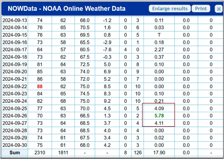
Asheville and the surrounding region took the brunt of the flooding, and nearly 14” of rain in three days is certainly unprecedented in Asheville since records began. But the NWS shows that this was actually spready evenly over all three days:
https://www.weather.gov/wrh/Climate?wfo=gsp
As can happen, atmospheric blocking meant the storm was trapped over the Asheville area for all three days. Daily totals of four or five inches are unusual but not unheard of. It was the duration of the rain that really caused the problems.
.
But that has not stopped the usual suspects blaming the floods on climate change.
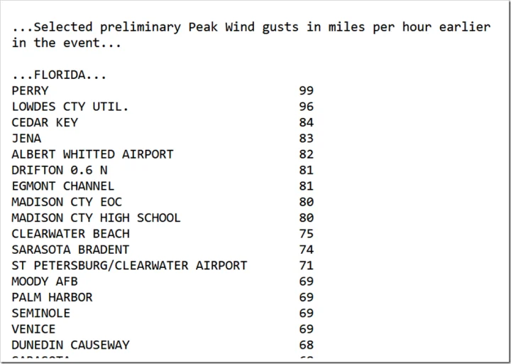
NWS have also published the wind speed data. In Florida peak gusts hit 99 mph (not sustained), a long way below the claimed Cat 4 levels.
140 mph sustained winds may have occurred somewhere out over the sea, but never got anywhere near that on land, at least where there was any measuring equipment.

https://www.wpc.ncep.noaa.gov/discussions/nfdscc4.html
Paul, I think you are on to something: Landfall winds far lower than the reported 140 mph.
Here is the eye wall at open sea, before and at landfall (from NWS graphic). Note the well defined open sea eye – indicative of a strong (Cat 4 – 5) storm, vs the landfall eye. I suspect this very rapid disintegration is due to friction from the Big Bend coast “wrapping around” the storm – slowing it MUCH more rapidly than the usual “straight” coastline. Ie, Big Bend “smothered” the eye. From the eye pics, my guess is the max sustained landfall winds were in the 110 to 120 mph range. Still very bad.
(I had lots of family in the storms path, all OK PTL Jesus.)
FYI, here is the NWS graphic: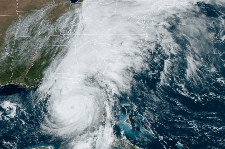
Doesn’t look nearly as slow moving as Harvey was. Now that was a stalled storm
“Doesn’t look nearly as slow moving as Harvey was.”
Harvey was a slow mover.
We had a two-year drought going on here in Oklahoma at the time, as 2010 and 2011 were very hot and dry years around here. Harvey came through and relieved the drought.
By the time Harvey got to Oklahoma it was mostly a rain event with a few tornadoes tagging along.
I was in a Typhoon while in Vietnam in 1968 (don’t know its name) and it dropped 22 inches of rain on us in 24 hours. At the time we were located right along a small, lazy creek. This creek turned into a roaring river in a matter of hours and we had to move to higher ground.
I was at home in New Braunfels Texas, a hundred miles northwest of Victoria, where Harvey sat stalled. Our rain gauge registered around 17 inches. We were on the downhill side of the circulation. Houston was on the uphill side, and really got hammered by much more rain. It’s only a few feet above sea level there, and it’s some 50 miles away from the Gulf, so the water drained slowly through its canal to the Gulf. We had few problems from the rainfall amount since heavy rainfalls are more common in New Braunfels than in Ashville, some 250 miles from the Atlantic Ocean.
Same reason for the 2013 flood in calgary, the jet stream wrapped around and trapped a low pressure system against the mountains for 3 days of rain instead of it moving along as usual .
random chance
Ventusky shows max sustained winds of 136-141MPH at 5pm on Sept 26…@ur momisugly 6500-8000′ Above Sea Level but only 92MPH at 10M AGL at the that same time
It would appear that at some point in time since 1989, it was decided to categorize storms according to the maximum sustained winds measured where theyre the strongest, at altitude, rather than maximum sustained at ground level, where people are affected.
If NWS is giving wind speeds at anything other than near grade/sea level, that would be misleading because the connection to historical data would be lost or obscured. I hope they aren’t doing this.
140mph winds at ground level would be evident because there wouldn’t be any houses left along the hurricane’s path as the houses would be destroyed down to their foundations. Concrete slabs would be the only thing left. Did we see any of that this time around? I didn’t.
Interesting!!! Someone was able to hack my post as my original verified post was at 6500-8000′
and someone added the (ur momisugly) after the fact
Hmmm. The “ur momisugly” appeared again with the “@”
I don’t think anything malicious is going on here. I’ve had the exact same thing happen to me twice now. I think it is a glitch.
The Ventusky model and post processing is not accurately depicting the eyewall at least in regard to the magnitude of the wind speeds.
A dropsonde directly measured surface winds of 135 mph in the band of maximum wind [1].
Well, we’re not going to be able to deprive the sensationalists of even one element of their prized disastrousness.
The saga of Helene continues in Joe and Kamala’s forced ineptitude upon the suffering and deserving people of Appalachia. Instead, aid has been diverted away from citizens to immigrants.
Surely, immigrant votes are being bought, while the suffering people in the mountains of western Carolinas have the misfortune of being labelled Republicans.
Not true as the governors (Republicans) of the affected states have said they have been receiving substantial aid from the government, including FEMA moving in support before the storm hit.
I believe that the governor of North Carolina is a democrat. Anyway, boots on the ground are reporting that FEMA is doing “sketchy and shady stuff.” Example: https://x.com/ImMeme0/status/1842648530436911554
“The saga of Helene continues in Joe and Kamala’s forced ineptitude upon the suffering and deserving people of Appalachia. Instead, aid has been diverted away from citizens to immigrants.”
This is categorically not true. The governors have said they have received everything they have asked for from the federal government. If you have any evidence of this misleading and vile post you should post it otherwise shame on you.
FEMA is being viewed as an impediment by locals, and it’s so bad that at least one sheriff is threatening to arrest officials if they continue to block relief and rescue missions.
https://wltreport.com/2024/10/04/breaking-north-carolina-sheriff-threatens-arrest-fema-officials/
It is Biden who is restricting aid, making despicable statements about such, and dem strategists like David Axelrod who politicize the situation that you should criticize.
So you provide a right wing propaganda site that provides no proof of what you said. Just some sheriff complaining about FEMA. The Governors have said the are getting the relief they have requested so your post is compete BS. Do you have no morals?
Governors only see part of the situation. Listen to what the sheriff says and what is being reported by the locals. Make up your own mind.
I donated to the relief effort via Samaritan’s Purse.
https://www.samaritanspurse.org/disaster/hurricane-helene/?utm_source=Ggl&utm_medium=cpc&utm_campaign=m_YGND-B24V&utm_content=HurricaneHelene&gad_source=1&gclid=EAIaIQobChMIiMzo0KX4iAMV8x6tBh2XxzD_EAAYASAAEgIPrfD_BwE
And Desantis says that the Federal response was not marshalled very quickly.
Why are you always pretending to know what is false?
You nailed Simon exactly. Simon, in his mind, is the judge of not only facts, but morals as well.
He will ask for your “proof” but will counter that proof with a commanding statement to the contrary.
So Governor Kemp asked for 90 counties to be claimed as disaster zones and only received 11. Now after repeated appeals, it’s up to 41. You’re smoking nonsense–as usual.
“Why are you always pretending to know what is false?”
Why are you always hiding behind ignorance.
“Instead, aid has been diverted away from citizens to immigrants.”
This statement is false and being spread to incite racial hatred, just like the eating dogs thing. And wadaya know, surprise surprise, Trump is the one saying it. He knows his disciples will lap it up without questioning the truth of it and sadly the post here by Scissor proves it.
Now if you can prove it is true, then let’s see what you have.
Are you sure it’s not the Russians? It would appear that your TDS blinds you.
Numerous people are reporting on their own “boots on the ground” perspective, such as the following.
https://x.com/ImMeme0/status/1842648530436911554
Social media? That’s your proof? Unbelievable.
Here are my news articles that say you are believing bullshite.
https://www.pbs.org/newshour/nation/disinformation-and-conspiracy-theories-cloud-helene-recovery-efforts-in-hard-hit-areas
https://www.bbc.com/news/articles/c5y3qgqxpwno
Propaganda press? I suppose you like they believed the 51 former intelligence (sic) officials.
https://www.newsmax.com/newsfront/brian-kemp-georgia-hurricane/2024/10/03/id/1182759/
Nowhere in your article does it say that money was diverted from from disaster relief to immigrants. Thats the vile racist lie I highlighted. I’m sure there was issues with relief getting the to right people. There always is during an horrific disaster like this.
https://www.foxnews.com/politics/kjp-slammed-after-hurricane-helene-over-mixed-messages-whether-fema-resources-used-migrants?msockid=02397ff783c264f0082d6bc08278659f
You should expand your searches.
You do know that the money used in the aftermath of Helene and other major disasters is not part of FEMA’s operating budget don’t you? (maybe you don’t?) It comes from the Disaster Relief Fund, which is appropriated by Congress.
https://www.axios.com/2024/10/03/hurricane-helene-fema-funding-mayorkas
Gee, I wonder where all that money went. And it’s not 20 million, it’s more like 2 million.
From your article.
“The bottom line: This is not the first time the government’s disaster relief fund has faced monetary perils as the climate crisis deepens.”
You seem to specialise in own goals.
And just for the record you should know what NaZI is before accusing me of being one. It is not my messiah who talks about poisoning the blood of a nation in much the same way Hitler did. I’d say Trump is a whole lot closer to one than me.
“Thats the vile racist lie I highlighted.”
You know, you silly leftists should expand your repertoire.
Don’t like windmills–racist!
Don’t like solar panels–racist!
Don’t like paying off student loans–racist!
Don’t like illegal immigration–racist!
Don’t like EVs–racist!
Don’t like giving foreign countries billions while not supporting our citizens–racist!
Your silly opinions mean nothing anymore.
“Thats the vile racist lie I highlighted.”
I like the “vile” adjective. You really are a low-life. What I think is vile is Nuremberg. That’s where NAZIs like you did their thing.
All racism is vile, particularly when it spews from a man looking to use it for political gain. And clearly you have no idea what racism is if you think not liking windmills or solar panels or paying off student loans is racist.
You should realize that claiming racism on everything means nothing is racist. It’s typical nonsense leftism.
But I haven’t claimed any of the silly things you quoted are racist.
So do you think it OK that Trump says immigrants are poisoning the blood of the nation? In my world you could not make a more racist comment.
“In my world you could not make a more racist comment.”
You should stop projecting. Why do racists think that calling their opponents racists is appropriate.
Do you realize that FEMA is concerned about their “hurt” feelings and not the death of 230+ Americans and a another missing 100+. We are dealing with an incompetent government agency.
What about you Mr Concerned… are you worried enough about the deaths of these people to consider the possibility that these large storms are going to get larger going forward? I’m picking not.
And your idiot Biden-Harris administration is doing nothing about it. These are deaths of US citizens. And you care nothing about them! These people have lost everything, and Harris is laughing about it.
“These people have lost everything, and Harris is laughing about it.”
So can you point me to where Harris is laughing at dead people or where people have lost everything are being laughed at by her? Otherwise this is just another lie from you. I must say I am beginning to wonder abut you….
Are you really being serious? You know you’re full of it!
Harris laughs at everything.
She certainly laughed at Trumps cats and dogs comment. But then so did the rest of the planet.
You are locked on one statement that Trump repeated. It’s only lying if you make it up. Quoting someone else is not lying. Now Harris is talking about stuff is stuff–and cackles away. She can’t even talk in a town meeting without a teleprompter.
Huh? These storms are becoming less common. If you knew anything about Thermodynamics–you’d know.
Yes, the officials at the NWS, or NHC have been inflating hurricane category for some time. I’ve tracked this trend since at least 2017. They bump up by 1 or 2 categories above the actual surface level wind speeds. They do this by either relying on a very rough and inaccurate relationship between central pressure and wind speed, or by merely taking flight level winds from 10,000 feet above sea level and not reducing them (ALL UPPER LEVEL WINDS ARE HIGHER THAN AT GROUND LEVEL)
Here is an example for Helene, via the actual data transmitted from a hurricane hunter aircraft, about an hour before landfall attached.
Notice the surface level winds are reported at 105-106 mph, while one small zone at 10,000 MSL (above Mean Sea Level) was 148.5 mph peak.
This surface wind report corresponds to the peak wind level at ground stations, and we most certainly did not observe Category 4 wind damage anywhere on land.
Don’t get me wrong, a CAT2 storm is not fun at all, I’ve been through the eyewall of 3 CAT2 storms and it is serious business. But crying wolf about CAT 4 will only lead people to ignore warnings in the future. (and of course inflating storm strength feeds into the climate change cult narrative)
I’ve already explained this you to you once. You are misrepresenting the data here because you are deliberately picking the wind speed in the weakest part of the storm. That’s not how hurricanes are classified. I’ll repeat hurricanes are classified based on the band of maximum wind.
False. [Giammanco et al. 2012] [Powell & Uhlhorn 2009] [Franklin et al. 2003]
That’s your band of maximum wind. Using the standard 0.9 multiplier (which often underestimates surface winds) this is would be 135 mph.
No one is crying wolf. It really was a category 4. A dropsonde that specifically targeted the band of maximum reported 135 mph at the surface when the central pressure was 942 mb. Helene intensified over the next 2-3 hours bottoming out at 937 mb while the KTLH radar was observing upper level winds of nearly 190 mph. We cannot eliminate the possibility that Helene was actually generating winds in excess of the official intensity of 140 mph based on all of the available data.
It is a bit strange that no land-based weather station in Florida recorded hurricane strength winds (> 70 mph.) It is hard to believe that Helene generated 140 mph winds at a height of 10M when it came ashore, yet the closest weather station at Perry 10 miles north/northeast from landfall recorded 52 mph as the highest wind speed.
…right in line with expectations.
Remember…
1) Helene had a forward velocity of 26 mph which means it’s storm relative winds were 140 – 25 = 115 mph and so its western winds were no more than 115 – 25 = 90 mph [NHC]
2) Perry was in the western portion of the eyewall.
3 Perry is 14 miles (line of sight) inland with the wind having to traverse about 30 miles of land well beyond the typical immediate 20% reduction at only 1 mile of land interaction and more likely closer to 30%. [Batts et al. 1980]
I’m an engineer, not a meteorologist. But I’ve studied upper division thermodynamics and lots of physics. And that area is my childhood home (PC), so I’ve paid close attention to hurricanes.
If you look at the graphic I posted earlier, and watch the GIF, at sea a few hours before landfall, the eye is very well defined, like one would expect from a Cat 4/5. But at landfall, the eye loses definition, looking more like a cat 1 or 2. My view is that while it was still at sea, but within Big Bend (which has a curvature much like the storm’s), as I said, the coast, wrapping around it, dramatically slowed its winds.That would explain the lack of Cat 3 or 4 land based wind measurements.
So, that reasoning indicates it was really a Cat 4, but the unusual coast made it seem slower.
That said, the earth just came out of the Little Ice Age. What happens when one comes out of an ice age? It warms. Who knew. AND, as Dr. Wojick wrote in a past WUWT article, in a highly mathematical paper few in the world can understand, brilliant physicists van Wijngaard and Happer proved that the earth is already in CO2 saturation. (Several years ago, I proposed a saturation experiment: In a pressure cylinder, with a laser and detector opposite, increase the CO2 pressure until the beam can’t make it across the chamber. Then calculate the number of CO2 molecules in its path. This is saturation. Basically, vW & H did my experiment theoretically.)
No, the storm was being weakened by the intrusion of cold, dry air from a cold front coming in the NW. As such the angular momentum was out of balance from inflow vs outflow, modulated by the Coriolis effect. Which is why Helene flung rain bands out some 900 miles from the storm. The low central pressure sucks air in near the surface, which spins due to Coriolis CCW. The air flows up and exhausts at high altitudes, and flows CW there. Typically the lower the central pressure, the higher the wind speed flowing into the eye at the surface, but a storm must also have an equal amount of outflow at the top, or it cannot form or once formed, weakens. There is a humongous mass of air in these conjoined vortexes, and this angular momentum of millions of tons of air spinning around the center – if the outflow is not matching the inflow, the storm will fling off squall lines far from the storm proper.
We saw this with Helene, a day or more before landfall, it was flinging squall lines up to Kentucky or Ohio, suggesting it was weakening substantially and the stored energy of the angular momentum was simply flying apart the storm.
Correct. And when AF306 mission 18 dropsonde 5 measured 135 mph in the band of maximum wind the central pressure was 942 mb. AF306 went on to observe further intensification in the next 2-3 hours with a central pressure of 937 mb. It is unequivocal and indisputable. Helene was still strengthening as it approached land. All observations including radar, flight level, dropsonde, ADT, buoys, land stations, tide gauges, etc. were consistent with Helene being a category 4 storm.
No it is you who are misrepresenting data or making stuff up that either does not exist, or you have no evidence for and is hearsay..
Hurricane category is based on wind speed at the ground (less than 10m), being sustained over a 1 minute period. The data from the Vortex message from the C130 listed in my comment above, states clearly that the surface MAXIMUM wind speed both inbound and outbound (in other words plane is flying towards the eye inbound and away from the eye outbound) in mph, as MEASURED by SMFR. Stepped Frequency Microwave Radiometer
Which SMFR is detailed here:
https://www.aoml.noaa.gov/hrd/project2005/sfmr.html
Furthermore, as early as 1999 and Hurricane Floyd, the early generation SMFR data and accuracy are depicted in this image:
https://www.aoml.noaa.gov/hrd/floyd_sfmr.html
Notice, surface winds in the eyewall (red trace) are always lower than at flight level. And dropsonde measurements confirm this, as well as showing SMFR to be an accurate method to determine surface wind speed.
Back to the Vortex message data, maximum surface winds were 105 to 106 mph, hence the storm was a Category 2, one hour before landfall.
As to your claim that radar at KTLH reported upper level winds at 190 mph – where’s the beef? As it stands your claim is hearsay, or non existent. In fact KTLH radar velocity only goes to +/- 100 on the scale of the Super Resolution Base Velocity plot as seen here:
https://radar.weather.gov/station/KTLH/velocity/standard.
Further discounting your diatribe, Helene made landfall at Dekle Beach, which is 10 miles South to SouthWest of Perry. Hence Perry was on the EASTERN side of the eyewall, or the most powerful, where forward speed adds to the wind speed.
Your arguments do not hold water. It was a Cat 2 at landfall, not a Cat 4. And based on this same pattern of the NHC over categorizing tropical cyclones since at least 2017, I doubt very much it was ever a Cat 4 even well out to sea. And wind damage supports this objective conclusion based on multiple sources of wind speed data on the ground and from the hurricane hunter Vortex data. Nowhere do we see destruction like that of Charley or Andrew which were both actually Cat 4 wind speeds.
…in the band of maximum wind.
That is lines H and L. It is either an SFMR observation or a human visual estimate.
AF306 did not have an operational SFMR on this mission so lines H and L were a human visual estimate.
False. You’re own link disagrees with your claim.
Yes. Dropsondes are excellent method for measuring surface winds. It just so happens that this very AF306 mission dropped one into the band of maximum wind and measured 135 mph.
Yes. SFMR is an excellent method for measuring surface winds. It’s unfortunate that AF306 did not have an operational SFMR.
…as eyeballed by a human and not in the band of maximum wind.
Here
Then you should stop using plots that with a scale that does not include observed wind speed. I recommend examining the raw radar data using GR2Analyst.
My argument is that Helene was a category 4 hurricane based on an actual direct surface wind speed measurement of 135 mph. Corroborating lines of evidence include WSR-88D radar measurements, flight level measurements, ADT measurements, buoy measurements, and land station measurements.
And there it is. Your argument is based on unsubstantiated fraud and conspiracy accusations. Hitchens Razor. What can be asserted without evidence can be dismissed without evidence.
How did they measure those high-altitude “band of maximum wind” areas of hurricanes prior to WW II? How about 1900? How are those measurements directly comparable to today?
The band of maximum wind is not high altitude. Well, not strictly anyway. It is the band extending throughout the whole vertical column of the eyewall in which wind speeds are the highest. The column isn’t always perfectly upright. It is often titled such that winds at flight level can actually be slower than the nadir winds at the surface. This column does not wrap around the cyclone either. It is usually confined to a smaller arc length of the whole eyewall ring. Anyway, the NHC HURDAT2 database is created using reanalysis models some with multiple storm centered nested grids to constrain the possible horizontal and vertical structure of each cyclone so that it is consistent with all observations. The grids are formed using variational assimilation to optimize (or reduce) the error of the grid based on all of the observations available for the domain. HURDAT2 uses a stable methodology in which cyclone intensities can be directly compared even for cyclones with vastly different dates of occurrence. The one obvious caveat is that cyclones occurring earlier in the period have high uncertainties.
A good example of the myth that upper level winds are always faster is Milton. Just a few minutes ago NOAA2 reported 154 kts flight level and a dropsonde reported 161 kts at the surface. Here the surface winds were faster.
View from the left: climate change caused Helene
https://us2.campaign-archive.com/?e=03c7393f3d&u=7c733794100bcc7e083a163f0&id=58aa7b9a1c
The wacko Alex Jones is having field day claiming the entire event was orchestrated by “military weather control” or something along these lines.
Nutso.
Extreme claims at both ends of the spectrum do little to enrich understanding or serve the public good. However, at least Alex Jones is not taxpayer-funded extremism or widely distributed by the media posing as “news”.
Rainfall of this magnitude can occur in many places and doesn’t require climate change or even something as dramatic as a hurricane landfall. There is a storm of this intensity (in terms of rainfall) at least once per decade someplace along the front of the Rocky Mountains from Raton Pass, NM to north of Cheyenne, Wyoming. The latest was over Boulder, CO in September 2013. Then there are occasionally very heavy rains in the Black Hills and northwest Nebraska.
In the case of Cheyenne a thunderstorm got stalled over the city on the afternoon of August 1, 1985. Estimated rainfall totals in one day were as high as 8 inches — 14 people were drowned.
The probability density of extreme weather events has a very long tail.
I don’t know how or just where it was measured but in 1791 the crest at Asheville NC was only 0.1 feet lower the record Helene crest.
I wonder what the weather was like then?
It probably won’t change your conclusion much, but I suggest revisiting the rainfall record after USGS restores service to the gages along the French Broad River. They seem to be down due to storm damage.
https://waterdata.usgs.gov/nc/nwis/current/?type=precip&group_key=county_cd
The area upstream from Ashville received steady rain for the two weeks prior to Helene. This can be seen on several other gages at the USGS. I have a private report from a civilian observer, near Brevard, of 30 inches of rain total as of 31st September. The same source provided images, taken before Helene, of places I visited last year, already flooding on the 24th and 25th.
This was not just one weather event, but several of which the Hurricane was the capper. With the river already on its banks, I am skeptical of any claims that engineering or emergency services could have done anything. This is weather, not climate con. But IMO the lessons from Helene should be twofold: 1) neither humans nor their works can beat nature 2) Monday morning produces the best quarterbacks.
Very helpful Paul.
Similar flooding events occurred in this area in 1916 and 1791. 3 times in 233 years. This was a 1 in 100 year rainfall event based authentic statistics/climate/meteorology, NOT a 1 in 1,000 year rainfall event.
Like the first 2 record flooding events, over a century ago, the topography of this area, along with the natural variability of weather was the MAIN cause NOT climate change. The warmer ocean/atmosphere holding more moisture likely added ~7% MORE rain. So the highest totals over 20 inches would likely have seen 1.5 inches less rain with the “OLD” climate of 100+ years ago.
https://www.marketforum.com/forum/topic/107518/#107846