Alternate title: Carolina Bays are as antithetical to impact craters as any dents in the ground possibly could be.
Guest essay by David Middleton
Introduction
In my previous essay, we discussed the differences between uniformitarian geology and drawing cartoons on Google Earth images. Several commentators brought up the “Carolina Bays” in defense of crater hunter cartoonists. Carolina Bays have also been cited as evidence for the Younger Dryas Impact Hypothesis (YDIH). Since I was already in the process of composing a post on Carolina Bays, my second post on uniformitarian impact craters will focus on Carolina Bays and other obviously wind-oriented geomorphological features.
Please note: This post is not about the pros and cons of the YDIH. Much of the evidence presented supporting the YDIH is interesting and some of it might even be compelling. This post is about one aspect of the evidence put forward on behalf of the YDIH: the Carolina Bays. As “evidence” of the YDIH, the Carolina Bays might even be worse than amateur crater hunters drawing cartoons on Google Earth images. I am happy to entertain questions and even genuine debate about the geomorphology, stratigraphy and other geological/geophysical aspects of the Carolina Bays and related features. Comments that start out with, “But how can you explain [the black mat, nanodiamonds, microspherules, the Terminal Pleistocene extinctions, Clovis culture or the lack thereof, biomass burning, etc.] will receive the following reply:
Non sequitur = Does not follow from. The Carolina Bays being impact craters does not follow from other possible evidence for the YDIH.
Please also note: This is a long post and I just made it longer with the preceding paragraph. If you don’t want to read it… then don’t. If you don’t read it, but insist on commenting, my reply will unlikely be courteous… Particularly if the comment is along the lines of “TL DNR.” These sorts of comments will generally receive this sort of reply:
The other sample sites were in and around 15 Carolina Bays, a group of ≈500,000 elliptical lakes, wetlands, and depressions that are up to ≈10 km long and located on the Atlantic Coastal Plain (SI Fig. 7). We sampled these sites because Melton, Schriever (20), and Prouty (21) proposed linking them to an ET impact in northern North America. However, some Bay dates are reported to be >38 ka (22), older than the proposed date for the YD event.
[…]
Glass-Like Carbon.
Pieces up to several cm in diameter (Fig. 4) were found associated with the YDB and Bays, and their glassy texture suggests melting during formation, with some fragments grading into charcoal. Continuous flow isotope ratio MS analysis of the glass-like carbon from Carolina Bay M33 reveals a composition mainly of C (71%) and O (14%). Analysis by 13C NMR of the glass-like carbon from Bay M33 finds it to be 87 at.% (atomic percent) aromatic, 9 at.% aliphatic, 2 at.% carboxyl, and 2 at.% ether, and the same sample contains nanodiamonds, which are inferred to be impact-related material (see SI Fig. 11). Concentrations range from 0.01 to 16 g/kg in 15 of 15 Bays and at nine of nine Clovis-age sites in the YDB, as well as sometimes in the black mat, presumably as reworked material. Somewhat similar pieces were found in four modern forest fires studied (see SI Text, “Research Sites”).
Discussion
Age of the YDB.
The YDB at the 10 Clovis- and equivalent-age sites has been well dated to ≈12.9 ka, but the reported ages of the Carolina Bays vary. However, the sediment from 15 Carolina Bays studied contain peaks in the same markers (magnetic grains, microspherules, Ir, charcoal, carbon spherules, and glass-like carbon) as in the YDB at the nearby Topper Clovis site, where this assemblage was observed only in the YDB in sediments dating back >55 ka. Therefore, it appears that the Bay markers are identical to those found elsewhere in the YDB layers that date to 12.9 ka. Although the Bays have long been proposed as impact features, they have remained controversial, in part because of a perceived absence of ET-related materials. Although we now report that Bay sediments contain impact-related markers, we cannot yet determine whether any Bays were or were not formed by the YD event.
“Melton, Schriever (20), and Prouty (21)” are from 1933 and 1952 respectively. Frey (22) is from 1955. No one noticed the Carolina Bays as a distinct morphological feature prior to the advent of aerial photography.
↵ Melton FA, Schriever W (1933) J Geol 41:52–56.Google Scholar
↵ Frey DJ (1955) Ecology 36(4):762–763.CrossRefGoogle Scholar
When Carolina Bays were observed on aerial photos, the first hypothesis was that they were the result of a series of meteoric impacts, because they kind of look like craters. Subsequent work has found no evidence whatsoever that the shallow depressions were the result of impacts; and all of the age estimates make the Carolina Bays far older than the Younger Dryas. We will revisit the geology and age determinations of the Carolina Bays later in this essay.
This really struck me…
The other sample sites were in and around 15 Carolina Bays…
“In and around”? How about location maps? Lat/Lon or some other location data?
They cite the two papers from 60-80 years ago as a basis to investigate the Carolina Bays as potential impact sites, ignore everything published since 1955 and conclude with:
Although we now report that Bay sediments contain impact-related markers, we cannot yet determine whether any Bays were or were not formed by the YD event.
Of course you can “determine whether any Bays were or were not formed by the YD event, ” because there is no evidence to support this idea. Even if their “impact-related markers” constituted evidence for the YDIH, an air-bursting bolide*, 12,900 years ago would have showered the Carolina Bays with “impact-related” materials.
*Yes, I know that “air-bursting bolide” is redundant.
Impact event
The cometary impact hypothesis of the origin of the bays was popular among earth scientists of the 1940s and 50s. After considerable debate and research, geologists determined the depressions were both too shallow and lacking in any evidence for them to be impact features. Reports of magnetic anomalies turned out not to show consistency across the sites. There were no meteorite fragments, shatter cones or planar deformation features. None of the necessary evidence for hypervelocity impacts was found. The conclusion was to reject the hypothesis that the Carolina Bays were created by impacts of asteroids or comets (Rajmon 2009).
A new type of extraterrestrial impact hypothesis was proposed as the result of interest by both popular writers and professional geologists in the possibility of a terminal Pleistocene extraterrestrial impacts, including the Younger Dryas impact hypothesis. It said that the Carolina Bays were created by a low density comet exploding above or impacting on the Laurentide ice sheet about 12,900 years ago.[29] However, this idea has been discredited by OSL dating of the rims of the Carolina bays, paleoenvironmental records obtained from cores of Carolina bay sediments, and other research that shows that many of them are as old as, or older than, 60,000 to 140,000 BP.[13][14][15][30][31]
The Wikipedia entry is surprisingly quite good… Probably because there’s no Gorebal Warming or any other left-wing environmental aspect to the Carolina Bays and/or the YDIH.
Carolina Bays. The Carolina Bays are a group of »500,000 highly elliptical and often overlapping depressions scattered throughout the Atlantic Coastal Plain from New Jersey to Alabama (see SI Fig. 7). They range from ≈50 m to ≈10 km in length (10) and are up to ≈15 m deep with their parallel long axes oriented predominately to the northwest. The Bays have poorly stratified, sandy, elevated rims (up to 7 m) that often are higher to the southeast. All of the Bay rims examined were found to have, throughout their entire 1.5- to 5-m sandy rims, a typical assemblage of YDB markers (magnetic grains, magnetic microspherules, Ir, charcoal, soot, glass-like carbon, nanodiamonds, carbon spherules, and fullerenes with 3He). In Howard Bay, markers were concentrated throughout the rim, as well as in a discrete layer (15 cm thick) located 4 m deep at the base of the basin fill and containing peaks in magnetic microspherules and magnetic grains that are enriched in Ir (15 ppb), along with peaks in charcoal, carbon spherules, and glass-like carbon. In two Bay-lakes, Mattamuskeet and Phelps, glass-like carbon and peaks in magnetic grains (16-17 g/kg) were found ≈4 m below the water surface and 3 m deep in sediment that is younger than a marine shell hash that dates to the ocean highstand of the previous interglacial.
Modern Fires. Four recent modern sites were surface-sampled. Two were taken from forest underbrush fires in North Carolina that burned near Holly Grove in 2006 and Ft. Bragg in 2007. Trees mainly were yellow pine mixed with oak. There was no evidence of carbon spherules and only limited evidence of glass-like carbon, which usually was fused onto much larger pieces of charcoal. The glass-like carbon did not form on oak charcoal, being visible only on pine charcoal, where it appears to have formed by combustion of highly flammable pine resin.
Two surface samples also were taken from recent modern fires in Arizona; they were the Walker fire, which was a forest underbrush fire in 2007 and the Indian Creek Fire near Prescott in 2002, which was an intense crown fire. Trees mainly were Ponderosa pine and other species of yellow pine. Only the crown fire produced carbon spherules, which were abundant (≈200 per kg of surface sediment) and appeared indistinguishable from those at Clovis sample sites. Both sites produced glass-like carbon fused onto pine charcoal.
All told, Firestone et al., 2007 wasn’t batschist crazy. There was a fair amount of arm waving; but they didn’t really drift off into Art Bell land.
Next, the Science Fiction
Cue the theme from Twilight Zone. Firestone 2009 was essentially a variation of Firestone et al., 2007, with a few bits of SyFy tossed in,
West also investigated sediment from 15 Carolina Bays, elliptical depressions found along the Atlantic coast from New England to Florida (Eyton and Parkhurst, 1975), whose parallel major axes point towards either the Great Lakes or Hudson Bay as seen in Fig. 3. Similar bays have tentatively been identified in Texas, New Mexico, Kansas, and Nebraska (Kuzilla, 1988) although they are far less common in this region. Their major axes also point towards the Great Lakes. The formation of the Carolina Bays was originally ascribed to meteor impacts (Melton and Schriever, 1933) but when no meteorites were found they were variously ascribed to marine, eolian, or other terrestrial processes.
West found abundant microspherules, carbon spherules, glass-like carbon, charcoal, Fullerenes, and soot throughout the Carolina Bays but not beneath them as shown in Fig. 4. Outside of the Bays these markers were only found only in the YDB layer as in other Clovis-age sites.
Figure 3. The Carolina Bays are »500,000 elliptical, shallow lakes, wetlands, and depressions, up to »10 km long, with parallel major axes (see inset) pointing toward the Great Lakes or Hudson Bay. Similar features found in fewer numbers in the plains states also point towards the Great Lakes. These bays were not apparent topographical features until the advent of aerial photography.
Figure 4. At two sandy Carolina Bays magnetic grains, carbon spherules and glass-like carbon (vitreous charcoal) are found distributed throughout the Bay sediment.
[…]
Glass-like Carbon: Pieces of glass-like carbon, up to several cm in diameter, have been found in the YDB layer at most sites with concentrations in sediment ranging from 0.01- 16 g/kg. Glass-like carbon doesn’t exist naturally and the man-made varieties are shown to have a structure similar to Fullerenes (Harris, 2004). Nanodiamonds were found in a Carolina Bay sample. The PGAA analysis of glass-like carbon sample from the Carolina Bays is shown in Table 2. It is 90 wt.% C and analysis by 13C NMR indicated that it is 87 at.% aromatic, 9 at.% aliphatic, 2 at.% carboxyl, and 2 at.% ether. PGAA shows that the sample contains significant amounts of SiO2 (4.8 wt.%) and Al2O3 (1.0 wt.%), probably from contamination by YDB sediment. A significant quantity of nitrogen (0.66 wt.%) and trace amounts of TiO2 (0.067 wt.%) and FeO (0.08 wt.%) were found. The ratio of TiO2/FeO=0.8 is comparable to that found in magnetic grains and microspherules.
A sample from the Carolina Bays shown in Fig.8 was found to grade from glass-like carbon at one end to wood on the other. The wood was identified by Alex Wiedenhoft (private communication) as Yellow Pine, a species native to the Carolinas at the time of the YDB. Glass-like carbon can be produced by the thermal decomposition of cellulose at 3200 °C (Kaburagi et al. 2005) but such high temperatures would normally consume the entire tree. The composition of this sample is consistent with a tree that was impacted by a rapidly moving, high-temperature shockwave that produced glass-like carbon on only one side as it passed. The anoxic conditions following the shock wave would have stopped further burning.
Figure 8. A carbon sample from a Carolina Bay that varies from the shiny, melted appearance of glass-like carbon at the top to Yellow Pine on the bottom. This can occur if the sample were exposed to the 3200 ° shockwave that “melted” one side of a tree but failed to destroy it entirely due to anoxic conditions behind the shockwave.
Radiocarbon dates for six glass-like carbon samples from the Carolina Bays are summarized in Table 2. Dates range from 685-8455 yr BP, much younger than the age inferred from their statigraphic context. The discrepancies are not as large as for the carbon spherules suggesting that these samples are predominantly composed of tree cellulose with additional 14C-rich carbon mixed into the glass-like carbon by the shockwave.
Radiocarbon dates for six glass-like carbon samples from the Carolina Bays are summarized in Table 2 [Table 3?]. Dates range from 685-8455 yr BP, much younger than the age inferred from their statigraphic context. The discrepancies are not as large as for the carbon spherules suggesting that these samples are predominantly composed of tree cellulose with additional 14C-rich carbon mixed into the glass-like carbon by the shockwave.
The 14C dates for the “six glass-like carbon samples from the Carolina Bays” range from 685-8,455 years before present (1950 AD). Even after calibrating the 14C dates to calendar years, the bits of burnt wood are way too young to be evidence for the YDIH.
In Firestone et al., 2007 they allowed for the possibility that the glassy bits of burnt wood could have been the product of forest fires. Two years later and flying solo, the glassy bits of wood had been “exposed to the 3200 ° shockwave that “melted” one side of a tree but failed to destroy it entirely due to anoxic conditions behind the shockwave.” °F or °C? Not that it matters.
Even if the glassy bits of wood were the result of some sort of air-bursting bolide, it doesn’t constitute evidence for the Carolina Bays being impact features, much less evidence that they were suddenly created at the Younger Dryas Boundary (YDB). The Bay ridges range from 27 ka to well over 100 ka. The basin fill can be as young as a few hundred years old. Stuff falling out of the sky 12,900 years ago could have easily been buried in Carolina Bays, even in the ridges.
This has become one of the most oft-repeated memes among YDIH proponents:
West also investigated sediment from 15 Carolina Bays, elliptical depressions found along the Atlantic coast from New England to Florida (Eyton and Parkhurst, 1975), whose parallel major axes point towards either the Great Lakes or Hudson Bay as seen in Fig. 3.
It’s often accompanied by variations of this image:
The wrongness of the image above is spectacular.
Carolina Bays and Similar Features Do Not Point at the Great Lakes or Hudson Bay
There are several recent detailed USGS surficial geology quadrangles in which Carolina Bays and comparable features have been mapped in detail. Almost none of the “parallel major axes point towards either the Great Lakes or Hudson Bay.” If the major axes were parallel (as many are in the Carolinas), they couldn’t all point at any common feature.
These examples are from the Surficial Geologic Map of the Elizabethtown 30′ × 60′ Quadrangle, North Carolina (Weems et al., 2011).
Elizabethtown 7.5 minute quadrangle, surficial geology, Carolina Bay features generally have azimuths of 305-320° azimuths. As does much of the drainage and underlying structural geology. USGS
Zooming in on one of the more prominent bays:
Warwick Mill Bay. 310° azimuth.Map unit legend.
Big Juniper Bay and cross section B-B’…
Note that Qwm fills a depression in Qwb and Qhm fills depressions in Qwm and Qwb.
“LIDAR elevation image of 300 square miles (800 km2) of Carolina bays in Robeson County, N.C.” (Wikipedia).LiDAR image of Herndon Bay. (Modified after Moore et al., 2016).
The Carolina Bays have a western cousin: Nebraska’s Rainwater Basins; where we have a brand new, detailed map of a series of Rainwater Basins: Surficial Geology of the Fairmont 7.5 Minute Quadrangle, Nebraska (Hanson et al., 2017).
Azimuths of Rainwater Basins in the Fairmont 7.5 minute quadrangle range from 10-87°. The large Rainwater Basin in the south-central portion of the map appears to have migrated to the northwest. (Modified after Hanson et al., 2017)This Rainwater Basin appears to have migrated from Section 22, to Section 15/21, to Section 16.Map unit legend for Fairmont quadrangle.
Put it all to together and we have:
Maybe the bolides exploded over Nebraska and North Carolina, bombarding the Great Lakes and Saskatchewan with eolian debris (/SARC)
I could pull geologic maps all day long, and the results would only get worse for the Carolina Bays being evidence for the YDIH. Which makes me wonder if Firestone ever looked at any geologic maps.
The older, lower resolution Quaternary geologic map of the Savannah 4 degrees x 6 degrees quadrangle (Colquhoun et al., 1987) covers all of South Carolina and much of Georgia and North Carolina. While most of the Carolina Bays trend from NW-SE, some trend from N-S, some aren’t even particularly elliptical.
Portion of Savannah 4×6° quadrangle. Red dashed ovals indicate N-S trending Carolina Bays.
Why Would Anyone Expect Impact Craters to be Elliptical?
Why are impact craters always round? Most incoming objects must strike at some angle from vertical, so why don’t the majority of impact sites have elongated, teardrop shapes?
Gregory A. Lyzenga, associate professor of physics at Harvey Mudd College, replies:
“When geologists and astronomers first recognized that lunar and terrestrial craters were produced by impacts, they surmised that much of the impacting body might be found still buried beneath the surface of the crater floor. (Much wasted effort was expended to locate a huge, buried nickel-iron meteorite believed to rest under the famous Barringer meteor crater near Winslow, Ariz.) Much later, however, scientists realized that at typical solar system velocities–several to tens of kilometers per second–any impacting body must be completely vaporized when it hits.
“At the moment an asteroid collides with a planet, there is an explosive release of the asteroid’s huge kinetic energy. The energy is very abruptly deposited at what amounts to a single point in the planet’s crust. This sudden, focused release resembles more than anything else the detonation of an extremely powerful bomb. As in the case of a bomb explosion, the shape of the resulting crater is round: ejecta is thrown equally in all directions regardless of the direction from which the bomb may have arrived.
“This behavior may seem at odds with our daily experience of throwing rocks into a sandbox or mud, because in those cases the shape and size of the ‘crater’ is dominated by the physical dimensions of the rigid impactor. In the case of astronomical impacts, though, the physical shape and direction of approach of the meteorite is insignificant compared with the tremendous kinetic energy that it carries.
“Only roughly 5% of all craters (greater than 1 km in diameter) observed on Mars, Venus, and the Moon have elliptical shapes with an ellipticity of 1.1 or greater”…
Planetary and Space Science
Volume 135, January 2017, Pages 27-36
Oblique impact cratering experiments in brittle targets: Implications for elliptical craters on the Moon
Tatsuhiro Michikami, Axel Hagermann, Tomokatsu Morota, Junichi Haruyama, Sunao Hasegawa
[…]
Only roughly 5% of all craters (greater than 1 km in diameter) observed on Mars, Venus, and the Moon have elliptical shapes with an ellipticity of 1.1 or greater, where the crater’s ellipticity is defined as the ratio of its maximum and minimum rim-to-rim diameters (Bottke et al., 2000). Although elliptical impact craters may be rare on solid-surface planetary bodies, a better understanding of the formation of elliptical craters would contribute to our overall understanding of impact cratering. For instance, it is well-known that crater size depends on impact angle (e.g., Elbeshausen et al., 2009).
[…]
Fig. 2. Photographs of elliptical craters created by impacts into targets without a cavity at various impact angles. Projectiles came from the left of the photograph.
Do any of the simulated craters above look even remotely like Carolina Bay features? Many Carolina Bay features are very smooth ellipses, often with ellipticities >1.5.
“Elliptical impact craters are rare among the generally symmetric shape of impact structures on planetary surfaces.”
The transition from circular to elliptical impact craters
Dirk Elbeshausen, Kai Wünnemann, Gareth S. Collins
First published: 15 October 2013 https://doi.org/10.1002/2013JE004477
Abstract
[1] Elliptical impact craters are rare among the generally symmetric shape of impact structures on planetary surfaces. Nevertheless, a better understanding of the formation of these craters may significantly contribute to our overall understanding of hypervelocity impact cratering. The existence of elliptical craters raises a number of questions: Why do some impacts result in a circular crater whereas others form elliptical shapes? What conditions promote the formation of elliptical craters? How does the formation of elliptical craters differ from those of circular craters? Is the formation process comparable to those of elliptical craters formed at subsonic speeds? How does crater formation work at the transition from circular to elliptical craters? By conducting more than 800 three‐dimensional (3‐D) hydrocode simulations, we have investigated these questions in a quantitative manner. We show that the threshold angle for elliptical crater generation depends on cratering efficiency. We have analyzed and quantified the influence of projectile size and material strength (cohesion and coefficient of internal friction) independently from each other. We show that elliptical craters are formed by shock‐induced excavation, the same process that forms circular craters and reveal that the transition from circular to elliptical craters is characterized by the dominance of two processes: A directed and momentum‐controlled energy transfer in the beginning and a subsequent symmetric, nearly instantaneous energy release.
1 Introduction
[2] The vast majority of impact craters on planetary surfaces, moons, and asteroids are circular in plan. Only 5% of the crater record—at least on Mars, Moon, and Venus—shows an elliptical morphology [see e.g., Schultz and Lutz‐Garihan, 1982; Bottke et al., 2000]. Elliptical craters result from impacts that occur at a very shallow angle of incidence. If a cosmic object (projectile) strikes the planetary surface (target) at an angle smaller than a certain threshold angle, the resulting crater shape deviates from a circular symmetry and becomes elongated in the direction of impact. The ellipticity of the crater increases with decreasing impact angle [Gault and Wedekind, 1978]. From the point of view of celestial mechanics, moderately oblique impacts are the norm and the most likely angle of incidence is 45°. Half of all impacts occur at even shallower angles and only ~5% of all impacts strike the target at an angle of 12° or less [see Gilbert, 1893; Shoemaker, 1962]. Accordingly, Bottke et al. [2000] concluded that the threshold angle to form elliptical craters must be 12° in order to match the observational record that 5% of all craters have an elliptical morphology.
[3] More detailed studies both by laboratory experiments [Gault and Wedekind, 1978; Christiansen et al., 1993; Burchell and Mackay, 1998] and numerical simulations [Collins et al., 2011] revealed that the angle below which elliptical craters form, the so‐called critical angle, depends on the properties of the target material. Based on numerical models of oblique crater formation and results from laboratory experiments, Collins et al. [2011] proposed that the critical angle for the formation of elliptical craters is a function of cratering efficiency, here defined as the ratio of crater and projectile diameter.
[…]
[11] Ellipticity ε is defined as the length of a crater divided by its width. To distinguish a circular from an elliptical shape, some sort of threshold value has to be defined for ε. This is a relatively arbitrary choice; however, to stay in line with previous studies on this subject, we follow the definition by Bottke et al. [2000], who consider craters as elliptical if the ellipticity ε is larger or equal to 1.1.
Elbeshausen et al., 2013, Figure 5 Ellipticity as a function of the impact angle and cohesion (projectile diameter L = 500 m, friction coefficient f = 0.7, impact velocity is U = 8 km/s).
The Pleistocene substratum of Carolina Bays and Rainwater Basins is largely unconsolidated sand. Even Pleistocene “sandstone” buried at depths of 20,000′ in the Gulf of Mexico tends to be poorly consolidated (friable in geologeese). Sand control is a major well completion issue in the Gulf of Mexico: Producing the oil & gas without filling up the wellbore with sand is often a challenge.
Herndon Bay is particularly elliptical. If we assume that the substratum is poorly consolidated sand, we find:
Cohesion of sand = 0.0 MPa
Herndon Bay ellipticity = 1.8
The impact angle would have had to have been about 1-2° and the meteoric object would have had to have impacted intact to generate such an elliptical crater. I don’t think there is an adequate adjective to tack onto “unlikely” to cover this bit. The next bit gets better.
There are 190 documented, confirmed impact craters on Earth (well, 189 if you don’t count Upheaval Dome). There are possibly 500,000 Carolina Bay type features on Earth, probably many more.
If only 5% of craters on Mars, the Moon, and Venus exhibit an elliptical morphology, generally defined as an ellipticity >1.1… What are the odds that 99.96% of the craters on Earth would be elliptical, with ellipticities often exceeding 1.5?
Now that we’ve demonstrated that Carolina Bays and similar features aren’t mysteriously pointing at the Great Lakes or Hudson Bay, were formed thousands of years prior to the YDB, that elliptical craters are rare and that it would be almost impossible for Carolina Bays to be elliptical impact craters, let’s look at one of the most well-documented Carolina Bays.
The full text is available. It’s the most thorough geological and geophysical investigation of a Carolina Bay feature I have been able to locate.
ABSTRACT
Geological investigations of Herndon Bay, a Carolina bay in the Coastal Plain of North Carolina (USA), provide evidence for rapid basin scour and migration during Marine Isotope Stage (MIS) 3 of the late Pleistocene. LiDAR data show a regressive sequence of sand rims that partially backfill the remnant older portions of the bay, with evidence for basin migration more than 600 meters to the northwest. Basin migration was punctuated by periods of stability and construction of a regressive sequence of sand rims with basal muddy sands incorporated into the oldest rims. Single grain OSL ages place the initial formation of each sand rim from oldest to most recent as ca. 36.7 +/- 4.1, 29.6 +/- 3.1, and 27.2 +/- 2.8 ka. These ages indicate that migration and rim construction was coincident with MIS 3 through early MIS 2, a time of rapid oscillations in climate. The fact that Carolina bay basins can migrate, yet maintain their characteristic shape and orientation, demonstrates that Carolina bays are oriented lakes that evolved over time through lacustrine and eolian processes. This research also indicates that Carolina bays can respond rapidly during periods of climatic transition such as Dansgaard-Oeschger or Heinrich events.
Figure 3 from Moore et al., 2016:
Figure 3. LiDAR imagery and elevation profiles for Herndon Bay: a) 3D LiDAR view [20 percent exaggeration], b) LiDAR planview showing elevation, GPR transect [white line], and Geoprobe core locations, c) and d) elevation profiles showing Geoprobe® core and OSL sample locations/ depth. The LiDAR data are provided by the North Carolina Floodplain Mapping Program (http:// www.ncfloodmaps.com/) and were collected using 3-5 meter point spacing and a vertical accuracy of less than or equal to 20 cm Root Mean Squares Error (RMSE).Cores were taken from the the four ridges (HB1, HB2, HB3 and HB4). The latitude and longitude of each core is clearly identified and the depth from which the three Optically-Stimulated Luminescence (OSL) samples were extracted are clearly documented. The sandy rims become progressively younger as the bay migrated from SE to NW. It’s kind of difficult for impact craters to migrate.
The youngest sandy rim, HB1, was deposited about 15,000 years before the Younger Dryas.
Figure 9. Single grain OSL age estimates (computed at one-sigma) for sand rims plotted over the GISP2 Oxygen Isotope curve (Ice core data provided by the National Snow and Ice Data Center, University of Colorado, Boulder [http://nsidc.org/] and the WDC-A for Paleoclimatology, National Geophysical Data Center [http://www.ncdc.noaa.gov/paleo/wdc-paleo.html], Boulder, Colorado), Grootes and others, 1993. Dansgaard-Oeschger events (2-8) are indicated by number (Dansgaard and others, 1993).It’s funny… Since the mid-1990’s, Optically-Stimulated Luminescence (OSL) has literally revolutionized Quaternary geology and geoarchaeology.
What is OSL?
OSL is an acronym for Optically-Stimulated Luminescence.
Optically-Stimulated Luminescence is a late Quaternary dating technique used to date the last time quartz sediment was exposed to light. As sediment is transported by wind, water, or ice, it is exposed to sunlight and zeroed of any previous luminescence signal. Once this sediment is deposited and subsequently buried, it is removed from light and is exposed to low levels of natural radiation in the surrounding sediment. Through geologic time, quartz minerals accumulate a luminescence signal as ionizing radiation excites electrons within parent nuclei in the crystal lattice. A certain percent of the freed electrons become trapped in defects or holes in the crystal lattice of the quartz sand grain (referred to as luminescent centers) and accumulate over time (Aitken, 1998).
I wonder how many detractors of uniformitarianism also reject OSL… hmmm?
Oriented Lakes and Other Wind-Oriented Features
Maybe these impact craters are pointing at Tunguska? (/Sarc)
The oriented lakes of Tuktoyaktuk Peninsula, Western Arctic Coast, Canada: a GIS‐based analysis
M. M. Côté C. R. Burn
First published: 25 March 2002
Abstract
The orientation, size and shape of 578 lakes on Tuktoyaktuk Peninsula were obtained from 1 : 250 000 Canadian National Topographic Survey map sheets, using ArcView geographic information system. These lakes are outside the glacial limits in a tundra plain with <15m relief. The lakes range from 20 to 1900 ha, and have mean orientation N07 °E, with standard error 1.6°. The maps show 145 former lake basins, with lakes inset in 130 of these. The mean orientations of the basins and inset lakes are not statistically different from each other or the general population. Several theories have been proposed for the origin of the oriented lakes, and one theory attributes the orientation to cross winds establishing currents that preferentially erode the ends of the lakes.
Or, maybe, oriented lacustrine features are fairly common occurrences…
Growth Secrets of Alaska’s Mysterious Field of Lakes
Mari N. Jensen
June 27, 2005
The thousands of oval lakes that dot Alaska’s North Slope are some of the fastest-growing lakes on the planet. Ranging in size from puddles to more than 15 miles in length, the lakes have expanded at rates up to 15 feet per year, year in and year out for thousands of years. The lakes are shaped like elongated eggs with the skinny ends pointing northwest.
How the lakes grow so fast, why they’re oriented in the same direction and what gives them their odd shape has puzzled geologists for decades. The field of lakes covers an area twice the size of Massachusetts, and the lakes are unusual enough to have their own name: oriented thaw lakes.
“Lakes come in all sizes and shapes, but they’re rarely oriented in the same direction,” said Jon Pelletier, an assistant professor of geosciences at The University of Arizona in Tucson.
Now Pelletier has proposed a new explanation for the orientation, shape and speed of growth of oriented thaw lakes. The lakes’ unusual characteristics result from seasonal slumping of the banks when the permafrost thaws abruptly, he said. The lakes grow when rapid warming melts a lake’s frozen bank, and the soggy soil loses its strength and slides into the water. Such lakes are found in the permafrost zone in Alaska, northern Canada and northern Russia.
Previous explanations for the water bodies’ shape and orientation invoked wind-driven lake circulation and erosion by waves.
Even though the “thousands of oval lakes that dot Alaska’s North Slope” are oriented perpendicular to the prevailing wind direction, Pelletier’s model indicates that the cause is seasonal permafrost melting. Whether wind-driven or permafrost driven, they aren’t impact driven.
The fact is that the cause of oriented lake features is not known with any degree of certainty. However, meteoric impacts don’t fit any of the observations. It does appear that wind patterns play a significant role; but other local factors are also very important.
Just for grins, here’s another wind-oriented feature:
Isochore Map of Porous Norphlet Sandstone. (Frost 2010).
Pointing at the Great Lakes? Unfortunately, no. The Norphlet points at Minneapolis…
“Just a bit outside”… And 160 million years too early… And 20,000′ too deep.
The Norphlet is an Upper Jurassic formation deposited under very arid conditions. The Upper Norphlet is eolian and characterized by “Seif” dunes. Under Mobile Bay, the Norphlet is at a depth of about 20,000’… Yet, through the miracle of uniformitarian geology, it was relatively easy to characterize the Norphlet as an eolian sequence, rather than impact craters or Gulf of Mexican Ignimbrites.
Addendum 1: Herndon Bay GPR Transect
Moore et al., 2016 included a ground penetrating radar (GPR) transect. I did not discuss this in detail in the post largely because I was trying to directly reproduce as little of their paper as I could. There has been some confusion in the comments about what GPR transects are and what they reveal about Herndon Bay.
GPR data are acquired in time, not depth. The data are recorded and processed relative to the ground surface. In order to present the GPR transect as something resembling a geologic cross section, it has to be surface normalized or topographically corrected.
Topographic Correction of GPR Profiles Based on Laser Data
Abstract.
Data obtained by GPR (Ground Penetrating Radar) are displayed as a continuous cross-sectional profile. Surface, generally, is not flat. As a result, the image becomes distorted and the depth calculated from the surface no longer represents the true and exact position of electrically distinctive layers and objects in materials. In order to get real geologic cross section, GPR data must be corrected. This is paper discusses a new method using the color point cloud data obtained by a Vehicle-borne laser scanning system to compensate for elevation fluctuate. Elevation profile can be extracted from topographic data of survey site acquired using laser scanner, which can then be used to offset the error of GPR data. Through the discrete points in the survey line, each trace of the profile has its own elevation value showing a vertical difference from the reference profile with maximum elevation, then time shifts value of traces vertical offset versus the reference trace of profile can be obtained. At last, the results of topographic correction for radargrams that look extremely like the real geologic cross section are presented, which allows us to get a better profile interpretation and position of the objects and layers in the subsurface.
The GPR transect in Moore et al., was also corrected for terrain (surface normalization) using LiDAR.
The data were acquired with a 300 ns recording window. This is approximately 5-9 m. The depths on the GPR transect are gross approximations due to the variability of the velocity field. While a surface normalized GRP transect looks like a geologic cross section, it is not. It is a geophysical approximation of a geologic cross section.
On depth sections, the top of the Black Creek Group mud facies is essentially flat from the extant basin to second oldest rim. The mud facies under the oldest rim is about 1 m higher than the rest of the rims and basin.
Geoprobe core data reveal wave ravinement into the underlying Cretaceous muds, with muddy sand incorporated throughout the oldest sand rims during the initial period of high-energy lacustrine processes (Figure 4). Coring of sand rims demonstrates the scoured nature of the underlying mud facies, with an elevation drop between the older remnant basin surface to the east and the more recent basin due to scour associated with the initial period of migration and sand rim construction (Figures 3c and 4).
pg 155
[…]
The fact that Carolina bays can migrate, yet maintain their characteristic oval shape, orientation, and rim sequences demonstrates that these landforms are oriented lakes shaped by lacustrine and eolian processes. Clear evidence of basin scour into the underlying Cretaceous sandy mud, reveals that Carolina bays are capable of migrating while backfilling remnant basins with a regressive sequence of paleoshoreline deposits as the position of the basin margin changes through time.
pg 167
References
Côté, M. M. and Burn, C. R. (2002), The oriented lakes of Tuktoyaktuk Peninsula, Western Arctic Coast, Canada: a GIS‐based analysis.Permafrost Periglac. Process., 13: 61-70. doi:10.1002/ppp.407
Elbeshausen, D., Wünnemann, K., Collins, G.S., 2013. The transition from circular to elliptical impact craters.Journal of Geophysical Research Planets 118, 2295–2309.
Firestone, R. B., A. West, J. P. Kennett, L. Becker, T. E. Bunch, Z. S. Revay, P. H. Schultz, T. Belgya, D. J. Kennett, J. M. Erlandson, O. J. Dickenson, A. C. Goodyear, R. S. Harris, G. A. Howard, J. B. Kloosterman, P. Lechler, P. A. Mayewski, J. Montgomery, R. Poreda, T. Darrah, S. S. Que Hee, A. R. Smith, A. Stich, W. Topping, J. H. Wittke, W. S. Wolbach. Evidence for an extraterrestrial impact 12,900 years ago that contributed to the megafaunal extinctions and the Younger Dryas cooling.Proceedings of the National Academy of Sciences Oct 2007, 104 (41) 16016-16021; DOI: 10.1073/pnas.0706977104
Firestone, R.B. The Case for the Younger Dryas Extraterrestrial Impact Event: Mammoth, Megafauna, and Clovis Extinction, 12,900 Years Ago.Journal of Cosmology, 2009, Vol 2, pages 256-285. Cosmology, October 27, 2009
Frost, Weldon G. The Somewhat Accidental Discovery of the Mobile Bay Gas Field: A Story of Perseverance and Good Fortune. Search and Discovery Article #110133 (2010). Posted June 16, 2010
Hanson, P. R., A. R. Young, A. K. Larsen, L. M. Howard1, and J. S. Dillon. Surficial Geology of the Fairmont 7.5 Minute Quadrangle, Nebraska. USGS 2017.
Michikami, T., A. Hagermann, T. Morota, J. Haruyama, S. Hasegawa. Oblique impact cratering experiments in brittle targets: implications for elliptical craters on the Moon. Planet Space Sci, 135 (2017), pp. 27-36
Moore, Christopher & Brooks, Mark & Mallinson, David & Parham, Peter & Ivester, Andrew & K. Feathers, James. (2016). The Quaternary evolution of Herndon Bay, a Carolina Bay on the Coastal Plain of North Carolina (USA): implications for paleoclimate and oriented lake genesis.Southeastern Geology. 51. 145-171.
Weems, R.E., Lewis, W.C., and Crider, E.A, 2011, Surficial geologic map of the Elizabethtown 30′ × 60′ quadrangle, North Carolina: U.S. Geological Survey Open-File Report 2011–1121, 1 sheet, scale 1:100,000.
Zanner, C. William. Nebraska’s Carolina Bays. GSA Annual Meeting, November 5-8, 2001.
Subscribe to get the latest posts sent to your email.
306 Comments
Inline Feedbacks
View all comments
Mike
May 4, 2018 11:53 am
Nice presentation, and I found the material quite educational. With that said, the sarcastic comments from the author (e.g., I wonder how many detractors of uniformitarianism also reject OSL… hmmm?) is quite off-putting and comes across as somebody who can’t handle being scientifically questioned by others.
No. I just like sarcasm.
I actually enjoy being scientifically questioned. However, I really enjoy being unscientifically questioned by people who think they are being scientific, because it affords me a great opportunity to be sarcastic.
I haven’t spent much time studying the Powder River Basin. What little I have studied has more to do with subsurface geology than surficial.
Felix
May 4, 2018 12:10 pm
The site towards which the orientation of the bays allegedly points was not glaciated 12,800 or even 12,900 calendar years ago. That alone should settle the question, but it appears as if no amount of evidence will dissuade True Believers in the Gospel of the YDIH.
Reposting: https://youtu.be/wbsURVgoRD0
PS: The animation also shows what did cause the YD, ie an outburst of formerly ice-dammed cold, fresh water down the St. Lawrence. Same cause as the other Dryases (from different sources), the previous Heinrich Events (icebergs rather than already melted water) and the 8.2 K event. Also the comparable cold snaps in prior deglaciations.
The YD is no different from previous and subsequent events during glacial terminations. Nor is it associated with megafaunal extinctions, most of which happened before or after the YD. In the case of megafauna on islands, much later, only after people arrived there. Yet megafauna farther away from the alleged impact site than are the islands but on the continent were wiped out.
Every bit of supposed evidence for an impact has been repeatedly shown false. Yet this zombie conjecture continues to attract True Believers with religious fervor impervious to reason or evidence.
Felix,
That animation is a bit sloppy.
Water went down the interior rivers first – – Mississippi, Illinois, Wabash, Miami (OH), Allegheny — over many years. Then there was a major flow along the route of the Erie Canal through the Mohawk Valley — to the Hudson Valley and then to the Atlantic: NY map
Then the passage out via Lake Ontario and the St. Lawrence opened.
The video suggests that no water drained until the St. Lawrence valley ice melted.
It is more complicated.
Agree it’s not the highest possible resolution, and it doesn’t show the drainages. They have to be inferred from the position of the ice edge.
But it’s still fit for the purpose of showing that the ice sheet had already retreated past the alleged “impact site” by the start of the YD.
Never mind that the supposed southeastern and Great Plains “craters” don’t all align with the purported “site”. That’s especially true of the so-called “playas” of Texas and Oklahoma, which have the same origin as the basins of Kansas and Nebraska.
The “bays” or basins of Maryland, Delaware, Alabama and Mississippi also don’t point toward the Great Lakes. And, as David has shown, most of the Carolina Bays aim for Alaska.
Felix, May 4, 2018 at 12:10 pm
“The site towards which the orientation of the bays allegedly points was not glaciated 12,800 or even 12,900 calendar years ago.”
I have seen that video previously and I believe it provides only a crude estimate of glacial extents at the indicated times. I suspect the uncertainty in the location of the edge of the Laurentide Glacier in the Saginaw Bay area could easily be 100 miles or more during the retreating phase. If there was a major meteor impact at what is now Saginaw Bay about 12,900 years ago, it could easily have caused a very large and rapid retreat of the edge of the glacier in a matter of days or less and possibly by 100 miles or more, initially from the impact blast and then from melting caused by residual heat.
I was very skeptical about the impact hypothesis until very recently. But after reading up on both the pros and the cons, it now seems to me that there is quite of bit of tantalizing and intriguing evidence that supports the hypothesis, but there are still many questions to be answered. The location and timing in my mind are the most uncertain factors. But there is a fair amount of increasing evidence that it may have occurred about 12,900 years ago with the primary impact at Saginaw Bay. I believe the evidence is sufficient to warrant more detailed investigation, but nowhere near sufficient yet to push the idea from the hypothesis stage into the theory stage. A major investigation of the Saginaw Bay area for signs of a meteor or comet impact should be a high priority. If the approach was from the southwest as some circumstantial evidence suggests, I’m guessing that might point more toward a large comet fragment, which would be a much higher speed impact than from a meteor. Time will tell one way or the other, but I think it is premature to dismiss the hypothesis at present.
Oz,
I used the animation solely because it’s graphic and had been liked in comments to the first part of David’s post.
Using the actual geologic history of Saginaw Bay makes the case even worse for YDIH True Believers, as in totally untenable. As Bill Birkelad points out in a citation I link below (paragraphs mine) that:
“There are significant problems with Saginaw Bay, Michigan, being both an impact crater and source of ice impactors involved in the formation of the Carolina Bays.
“First, Saginaw Bay was partially ice-free starting about 16,000 BP and completely ice-free by 14,000 BP. Thus, there was not the thick ice sheet that could either be a source of bay-forming ice secondary impactors or cushion the underlying bedrock from an impact at the start of the Younger Dryas.
“Second, proglacial lake deposits, shoreline, and deltas as old as 16,000 BP ring all or parts of Saginaw Bay and unddisturbed deposits of the same age underlie it. Thus, Saginaw Bay is definitely too old to have been formed by a hypothetical Younger Dryas Impact.
“Maps of bedrock topography that have been created from abundant water and oil well holes show a complete lack of the kilometers-deep hole and associated bedrock deformation that such an impact would have created. The data can only be interpreted to conclude that the Saginaw Bay crater is a completely imaginary entity and, as a result, cannot be used to explain the Carolina Bays.”
One of Dr. Birkelad’s links, showing that Saginaw Bay was ice-free long before the YD: https://www.sciencedirect.com/science/article/pii/S0169555X17301368
We introduce, characterize, and interpret the geomorphic history of a relict, Pleistocene-aged delta of the Chippewa River in central Lower Michigan. The broad, sandy Chippewa delta developed into various stages of Glacial Lake Saginaw, between ca. ≈ 17 and 15 ka·BP (calibrated ages). Although the delta was first identified in 1955 on a statewide glacial geology map, neither its extent nor its Pleistocene history had been previously determined. The delta is typically forested, owing to its wet, sandy soils, which stand out against the agricultural fields of the surrounding, loamy lake plain sediments. The delta heads near the city of Mt Pleasant and extends eastward onto the Saginaw Lowlands, i.e., the plain of Glacial Lake Saginaw. Data from 3285 water well logs, 180 hand augered sites, and 185 points randomly located in a GIS on two-storied (sand over loam) soils were used to determine the extent, textural properties, and thickness of the delta. The delta is ≈ 18 km wide and ≈ 38 km long and is sandy throughout. Deltaic sediments from neighboring rivers that also drained into Glacial Lake Saginaw merge with the lower Chippewa delta, obscuring its boundary there. The delta is thickest near the delta’s head and in the center, but thins to 1–2 m or less on its eastern margins. Mean thicknesses are 2.3–2.9 m, suggestive of a thin sediment body, frequently impacted by the waves and fluctuating waters of the lakes. Although beach ridges are only weakly expressed across the delta because of the sandy sediment, the coarsest parts of the delta are generally coincident with some of these inferred former shorezones and have a broad, incised channel that formed while lake levels were low. The thick upper delta generally lies above the relic shorelines of Glacial Lakes Saginaw and Arkona (≈ 17.1 to ≈ 16 ka·BP), whereas most of the thin, distal delta is associated with Glacial Lake Warren (≈ 15 ka·BP). Together, these data suggest that the Chippewa delta formed and prograded as lake levels in the Saginaw Lowlands alternated and episodically fell. The result is a delta that is comparatively thin, expansive, and sandy. In some places, these sands have subsequently been reworked into fields of small parabolic dunes.
Felix, thanks for your replies and great information. This evidence does not preclude an earlier glacial impact as some like Moore have proposed. I also don’t know how reliable the dating is on these deltas by Saginaw Bay. If the dates are uncertain by a thousand years, then it does not preclude a YD impact timing. It also does not preclude the edge of the ice being at the mouth of Saginaw Bay where it still could have been impacted. As I mentioned in another comment, the timing and location appear to be the greatest uncertainties for the meteor or comet glacial impact hypothesis leading to secondary blasted ice impacts to form the Carolina bays.
Oz,
The Saginaw Bay dates are not uncertain by thousands of years, but certain by much less than a millennium. By contrast, the dating of the meltwater pulse down the St. Lawrence was reliably dated by geologic means to about the time of the YD, before the YD itself was recognized.
Moore’s hypothesis is preposterous. The bays date without doubt to the last glaciation, not 800,000 years ago. There are always charlatans looking to make an easy buck and gain notoriety by promulgating ludicrous fantasies, knowing that somewhere there will be people willing and gullible enough to run with them.
PPS: The history of the retreat of the Laurentide Ice Sheet across the Great Lakes has been known in great detail for over a century. The seminal work was published in 1911.
There were two Lake Saginaws, separated by a glacial advance during the Wisconsin Glaciation termination. The advance was the during the Older and Middle Dryases. The second Lake Saginaw also underwent various drainage changes and was at time part of other named proglacial lakes. This is science as settled as it can ever possibly be in geology.
The wild, baseless speculation of a YD hit on the ice sheet could only have been concocted by a fantasist totally devoid of geologic knowledge.
>>The site towards which the orientation of the bays allegedly
>>points was not glaciated 12,800 or even 12,900 calendar
>>years ago. That alone should settle the question, but it appears
>>as if no amount of evidence will dissuade True Believers in the
>>Gospel of the YDIH
But that is not true, is it?
The Carolina Bays point towards a location just to the north of the Great Lakes, and your animation shows this to be still covered with ice 12,800 years ago. Ergo, a meteor hitting that location could have splattered slushballs all over N America.
R
>>How did the “slushballs” survive the 3200°
>>shockwave that melted trees.
Ablation – the same way that rocket reentry vehicles survive such temperatures.
Water happens to have a huge latent heat of melting and latent heat of vapourisation, which makes it very difficult to sublimate a block of ice.
In addition, ice is a poor conductir of heat, while the shock-wave remains remote from the body causing it. The shock-wave, which can be thousands of degrees c, does not touch the ice.
Finally, these would be slow-speed slush-ball projectiles, and not the huge speeds of extraterrestrial bolides. They would be travelling at the speeds of the space shuttle, and less likely to completely break up into fragments.
R
John F. Hultquist
May 4, 2018 12:56 pm
David M.
James W. & others
I think I recall the last time this subject was posted, there was a comment or a link (?) to a paper trying to connect the impact on the Canadian ice to the “ice age floods” here in the Pacific North West – – meaning B.C., Mont., Id., Washington.
My thought then was “That’s ridiculous.”
Just up from here, y’all have segued to the ‘ seven ages ‘ project.
I guess it won’t be much off topic if I suggest the “Ice Age Floods Institute” (IAFI) [ iafi dot org ] to those interested in things about Earth’s surface.
One of the chapters is hosted by Central Washington University’s Karl Lillquist (geography) and Nick Zentner (geological sciences).
In addition to the ice age floods link (Tom Foster & others),
Nick has a bunch of videos on the web.
Search on
‘ Nick on the Rocks ‘, and
‘ 2 minute geology ‘
Thanks for this post (all the work), comments, and so on.
Double thanks.
I really like the Nick on the Rocks shows. He does quite a good job explaining geologic processes and the animations are excellent.
Personally, I think, based on the evidence so far, is that the megafloods in the PNW are unrelated to the YD event and we’re soley a function of retreating ice sheets.
Thank you for a most interesting article, David.
Your analysis of one of the latest arguments of the YD impact theory, the Carolina Bays formations is as demolishing as previous analysis of other arguments. It is particularly useful to me since Geology is quite unknown to me and I did not know how to answer to this one.
Sadly the appeal of catastrophic theories to people not well grounded on science is unending. I am not surprised at all that Ralfellis has embraced it.
It is clear to me that geology is capable of creating the most incredible structures from physical and chemical interactions. Anybody that has seen a geode can attest to that.
As you say the amount of information that contradicts an impact origin at the YD for the Carolina Bays, and the unbelievable set of circumstances that would be required for an impact origin, together with the total lack of evidence for such origin in the Carolina Bays, actually weakens the impact hypothesis.
There was a lot of publicity some time ago for circular structures that were appearing in Kamchatka as due to climate change factors. Myths are useful when one is short on science. Evidence should always be our guiding light.
No doubt. Coming from a geologist.
Life history and evolution happen in the same timeframe as geology, and Biology has gone through the same scientific controversy regarding gradualism versus punctuated equilibrium.
Not that many universities are any different.
Maybe in a second Trump Administration, you’ll be free to publish under your full and real name.
Again, if correct, you are a true polymath, and, like Dr. S, a valued, legal immigrant to these shores.
Javier May 4, 2018 at 2:47 pm
Yes, biology and geology are historical sciences. Astronomy is becoming more so.
The fact is that evolution happens both rapidly and slowly. This goes beyond the largely false distinction between “micro-” and “macroevolution”.
IMO it’s because Gould was a Marxist that he tried to make a big ideological deal about “punctuated equilibrium”. Indeed, he effectively admitted as much. The concept shouldn’t be considered a theory or even hypothesis, but simply an observation. But Gould chose to erect a grand theory based on this basic fact.
Human evolution provides ample examples of both rapid and gradual evolution. Probably a single gross chromosomal mutation facilitated upright walking, followed by gradual anatomical and physiological adaptations to improve bipedal locomotion. Same with a bigger brain. Around 2.7 Ma, a mutation permitted brain growth, after which our ancestors’ brains slowly got bigger for ~2.5 million years, until limited by the obstetrician’s dilemma.
While even some biologists still consider evolution mainly to be gradual, it can and often does happen in a single generation, in both microbes and multicellular organisms. Naturally, this applies more to speciation and the formation of new genera than to the evolution of families, orders, classes and phyla. For instance, most plant species probably have arisen via polyploidy. Nylon-eating bacteria evolved from a single point mutation.
I’d go farther and argue that even major transitions, such as from “fish” to “tetrapods”, can be seen as rapid rather than gradual, over millions of years. What is the key distinguishing feature separating lobe-finned fish from tetrapods? Arguably, it’s having wrist, hand and finger (ankle, foot and toe) bones rather than fin rods. The calcification and fusing of cartilaginous rods into these bones happened rapidly in geological terms, on a time scale of generations, but not millions of years.
Macroevolution entails the same processes as microevolution, but with more time.
Felix – if I understand you correctly (“after which our ancestors’ brains slowly got bigger for ~2.5 million years, until limited by the obstetrician’s dilemma”), then with the onset of C-sections, evolution of larger brains can commence?
Kook,
Yes. If C-section became the standard method of delivering babies, the limit on human brain size would be lifted. We could also be born later, although at the cost of more stretch marks and maternal discomfort.
Human newborns are extraeuterine fetuses. We take so long to learn to walk, compared to other mammals, because we spend so little time in the womb, relative to our size.
The dilemma arose because at the same time that our brains were growing, our upright walking and evolution of running lifestyle limited the size of the birth canal.
John F. Hultquist
May 4, 2018 4:00 pm
Gould has written nicely about “Deep Time” (McPhee’s term, I think) – – a concept as foreign to most folks as compound interest.
Doing some trail repair west of Yakima WA last weekend we were banging on rocks that were 15 m.y. old; we moved and were on rocks only 2 m.y. old. — both young, as such things go.
Yup. Lots of flood basalt of the older (yet still geologically young) rock in the inland PNW.
Amazingly, there is an even crazier conjecture for “bays” formation than the repeatedly falsified YD impact supposition. It tries to connect the bays with the Australasian tektite strewnfield, ~790,000 years old. https://agu.confex.com/agu/fm17/meetingapp.cgi/Paper/236973
Felix
May 4, 2018 4:43 pm
I hope that this analyst doesn’t mind my quoting him: https://www.andywhiteanthropology.com/blog/a-new-paper-on-the-origin-and-evolution-of-the-carolina-bays
Bill Birkelad 1/27/2018 07:49:40 pm
There are significant problems with Saginaw Bay, Michigan, being both an impact crater and source of ice impactors involved in the formation of the Carolina Bays. First, Saginaw Bay was partially ice-free starting about 16,000 BP and completely ice-free by 14,000 BP. Thus, there was not the thick ice sheet that could either be a source of bay-forming ice secondary impactors or cushion the underlying bedrock from an impact at the start of the Younger Dryas. Second, proglacial lake deposits, shoreline, and deltas as old as 16,000 BP ring all or parts of Saginaw Bay and unddisturbed deposits of the same age underlie it. Thus, Saginaw Bay is definitely too old to have been formed by a hypothetical Younger Dryas Impact. Maps of bedrock topography that have been created from abundant water and oil well holes show a complete lack of the kilometers-deep hole and associated bedrock deformation that such an impact would have created. The data can only be interpreted to conclude that the Saginaw Bay crater is a completely imaginary entity and, as a result, cannot be used to explain the Carolina Bays.
Go see:
Connallon, C.B. and Schaetzl, R.J., 2017. Geomorphology of the Chippewa River delta of Glacial Lake Saginaw, central Lower Michigan, USA. Geomorphology, 290, pp.128-141.
Kincare, K., and Larson, G.J. 2009. Evolution of the Great Lakes. In: Michigan geography and geology, Schaetzl, R.J., Darden, J.T., and Brandt, D. (eds.). Pearson Custom Publishing, Boston, MA. pg. 174-190.
Luehmann, M.D., 2015. Relict Pleistocene deltas in the Lower Peninsula of Michigan.
unpublished PhD dissertation, Michigan State University, East Lansing, Michigan.
As far as the Rainwater Basins in south-central Nebraska. are concerned, people overlook that they are geomorphic palimpsests. They are only the surface expressions of basins that are uniformly buried beneath a meters-thick blanket of undisturbed Holocene and Late Pleistocene loesses. The actual basins are buried beneath, from oldest to youngest, loess of the Gilman Canyon Formation (Middle Wisconsinan), Peoria Loess (Late Wisconsinan), Brady Soil (paleosol) developed in the Peoria Loess, and Bignell Loess (Holocene). The buried basins, which the modern Rainwater Basins overlie, cannot be younger than the start of the Middle Wisconsinan, 40,000 BP. This means that they were definitely not created by any hypothetical Younger Dryas Impact. Go see:
Kuzila, M.S. (1994) Inherited Morphologies of Two Large Basins in Clay County, Nebraska. Great Plains Research 4:51-63.
Kuzila (1994) states: “The modern basin landscape was determined to be a direct result of 2.5 to 8 m of loess deposition on an older basin landscape.”
Muhs, D.R., E.A. Bettis III, J.N. Aleinikoff, J.P. McGeehin, J. Beann, G. Skipp, B.D. Marshall, H.M. Roberts, W.C. Johnson, and R. Benton. (2008) Origin and paleoclimatic significance of late Quaternary loess in Nebraska: Evidence from stratigraphy, chronology, sedimentology, and geochemistry. Geological Society of America Bulletin. 120(11/12):1378-1407.
Also, there are multiple lines of evidence, such as undisturbed, well-dated pre-Late Wisconsin sediments filling Carolina Bays that have been cored for paleoclimatic studies, that clearly show that a number of them predate the start of the Younger Dryas by tens of thousands of years at a minimum. For an example, go see;
Lane, C.S., Taylor, A.K., Spencer, J. and Jones, K.B., 2018. Compound-specific isotope records of late-quaternary environmental change in southeastern North Carolina. Quaternary Science Reviews, 182, pp.48-64.
It would be interesting to know if the proponents of this hypothesis have even tried submitting manuscripts for publication to either the Journal of Geophysical Research, Geosphere, or other peer-reviewed journal and what specifically what the peer-reviewers had to say about their manuscript.
Another really interesting feature (to me) in Australia are these “dry” lakes which seem to be sliding generally from east to west across a fairly large flat landscape. As opposed to Carolina Bays, they remain essentially round in shape. I assume, but I have never gotten a scientific answer as to how these “sliding lakes” are formed. But I assume that it has to do with prevailing winds from east to west.
I have posed this question on WUWT several times in the past, but have never really been given a scientific answer. The coordinates are around here on Google earth:
33°29’00.76″ S 122°21’45.25″ E
Zoom out and just scroll around to see the expanse of the area mainly in Kau Nature Reserve, AU.
I have only gotten AU comments that these are only dry or salt lakes with no explanation as to why they seem to be sliding/repeating generally from East to West.
Regards, Phil
Possibly useful and relevant:
Study of the saline lakes of the Esperance Hinterland, Western Australia, with special reference to the roles of acidity and episodicity
Brian V. Timms
School of Environmental and Life Sciences, University of Newcastle, Callaghan, Australia https://digitalcommons.usu.edu/cgi/viewcontent.cgi?referer=https://www.bing.com/&httpsredir=1&article=1306&context=nrei
Australia of course lacked Pleistocene glaciation, except for a little snowfield or ice cap atop Tasmania.
One thing, The Carolina bays were not low lying 12500 BP. The sea level was approx. 300 ft lower. Putting Big bay SC at nearly 500Ft above sea level and the sea more than 300 miles from the ocean. Hardly coastal. In reality it was high and Dry.
The Greenland ice sheet had little to do with the continental ice sheet. Do you suppose high elevation temperatures like at the top of Greenland fluctuated along with coastal temps. Or could the colder temps and drier condition made less snow. So supposed excess melt periods where actually colder with less snow? You reject the scouring of the Hudson river basin and the rapid emptying of the melt water lakes 13 thousand years BP? You also reject the Land bridge that brought the Clovis peoples to the Americas? You also reject the theory of Doggerland in Europe. Good Luck!
When did I reject any of those things? The timing and migration of Herndon Bay’s rims coincides with D-O related interstadials. The Younger Dryas, part of the D-O cycle, has been associated with glacial advance following a retreat and with the Lake Agassiz glacial outburst flood (although the timing is wrong). The Laurentide ice sheet and sea level weren’t static during the last Pleistocene glacial stage.
The ice sheets and sea level wouldn’t have had to vary that much with D-O phases in order to alter local wind and hydrology.
Stan,
It was still a coastal plain. It was a little bit higher above sea level, but not enough to make a difference. Of course it was drier, due to cold and so much moisture locked up in the ice sheets.
The Carolina bays are mostly (maybe entirely) above the Fall Line today. The point about “coastal plain” is not that it’s right on the coast, but that it’s lower lying land downwind from the ice sheets but near the sea. That situation doesn’t obtain in Eurasia, with the possible exception of Beringia, much farther north and now submerged.
Check out the bathymetry of the SE coast. Unlike New England and Canada, the continental shelf is much narrower off the southern Atlantic coast. http://www.northernminer.com/wp-content/uploads/2016/12/Wisconsin_glacial_maximum.jpg
During the stadials the area was higher above seal level than during interstadials, but not necessarily dry. Carolina Bays exhibit a wide range of Pleistocene vegetation. The continental shelf is very narrow in the Carolinas. So the sea level fall wouldn’t have pushed the coast as far away as areas with wide continental shelves.
The “coastalness” wouldn’t have changed that much. They still would have been on the coastal plain.
The sand on the east coast of the US… AKA “Carolina beach sand” was created during the dry desert periods of the last 6 million years. Those dry periods were during the iceages. The sand wasn’t created by wave action. It was created in the vast eastern deserts of the Pleistocene. Why was it so dry? The better question is why is the eastern us so wet now? The huge size of the gulf of mexico due the higher sea levels and the massive inland waters… AKA the great lakes. Not to mention the moisture we get from western fronts without them having to cross mile high ice fields. The east coast in the time you suggest bank erosion was an exceptionally dry desert. Here is a map of Florida So you can rule out gulf coast moisture.
I did request sonar surveys of the continental shelf, but although they have surveyed the outer shelf, they have not surveyed the shoreline shelf. I was looking for undewater Bays, on the shelf.
R
Ralph,
Detailed bathymetry data are available for the whole continental shelf, much of it at sufficient resolution to find larger “bays”. https://maps.ngdc.noaa.gov/viewers/bathymetry/
William Astley
May 5, 2018 7:47 am
In reply to David’s comment.
David: Quote from above.
Even if the glassy bits of wood were the result of some sort of air-bursting bolide, it doesn’t constitute evidence for the Carolina Bays being impact features, much less evidence that they were suddenly created at the Younger Dryas Boundary (YDB). The Bay ridges range from 27 ka to well over 100 ka. The basin fill can be as young as a few hundred years old. Stuff falling out of the sky 12,900 years ago could have easily been buried in Carolina Bays, even in the ridges.
An air burst bolide that causes shock waves and 3200C burns on the surface of the earth are very, very rare and do no happen in the same region again and again.
How many of the Carolina Bay structures show evidence of the high temperature burn material? I am trying to get a picture in my mind of the relative locations of the sites where burn material was found. Is there evidence of repeated shock waves and high temperature burning in that region?
A confirmation that the majority of the Carolina Bay structures contain burn material would be interesting as it provides a strong hint as to cause.
What stuff are you assuming fell from the sky and was buried in the Carolina Bays, 12,900 year ago? What is the stuff that is found in the Carolina Bay structures that cannot be explained?
My believe was that the Carolina Bay structures were dated 27ka to 100ka as you stated above.
Firestone paper quotes
Radiocarbon dates for six glass-like carbon samples from the Carolina Bays are summarized in Table 2. Dates range from 685-8455 yr BP, much younger than the age inferred from their statigraphic context. The discrepancies are not as large as for the carbon spherules suggesting that these samples are predominantly composed of tree cellulose with additional 14C-rich carbon mixed into the glass-like carbon by the shockwave.
A sample from the Carolina Bays shown in Fig.8 was found to grade from glass-like carbon at one end to wood on the other. The wood was identified by Alex Wiedenhoft (private communication) as Yellow Pine, a species native to the Carolinas at the time of the YDB.
Glass-like carbon can be produced by the thermal decomposition of cellulose at 3200 °C (Kaburagi et al. 2005) but such high temperatures would normally consume the entire tree. The composition of this sample is consistent with a tree that was impacted by a rapidly moving, high-temperature shockwave that produced glass-like carbon on only one side as it passed. The anoxic conditions following the shock wave would have stopped further burning.
There’s nothing about the Carolina Bays that can’t be explained without invoking an impact. My point was that even if Firestone’s findings were accurate, they don’t constitute evidence that the bays were impact craters.
>>An air burst bolide that causes shock waves and 3200C burns on
>>the surface of the earth are very, very rare …. How many of the Carolina
>>Bay structures show evidence of the high temperature burn material?
It would be nice to know. But because the idea that the Bays are impact craters has been so comprehensively dismissed, nobody has bothered to look. Firestone found a vitrified wood sample – but is that sample unique or common? We do not know.
It has been claimed that bolides could not heat the surface to such a degree. But this would have been a unique event where a million secondary slush-ball projectiles would have reentered the atmosphere at the same time. The sky would have been lit up with thousands of 4000 degree projectiles, and one would expect that the result of these high temperatures would show up in the Bays. If it does not, then that is a mark against the impact crater theory.
It would also be nice to learn the dynamics of ice reentry projectiles, and the type of impact crater they might leave. But when asked for further information, a high energy impact lab declined to investigate, saying it was speculative nonsense. So we do not know, because nobody wants to know.
Ralph
Ralph,
The gross-scale phase diagram doesn’t apply to the actual biological situation. Cellulose is carbon plus oxygen and hydrogen (C6H10O5). Firestone relied upon the only actual experimental evidence which he had, which was totally inappropriate to the case at hand.
For instance, the triple point of CO2 is different from carbon, as it water’s from oxygen’s.
I will look at that again. Of course the phase diagram of CO2 will be different, as it is a completely different chemical. But the vitrified material is pure carbon – it is not CO2, and nor is it cellulose. So the phase diagram for pure carbon should apply to these samples..
I will look at this again.
R
Ralf,
The allegedly vitrified C came from cellulose, so the tree had to have burned before later reaching the temperature to vitrify C. So for Firestone’s hypothetical heat blast wave scenario to work, air hot enough to have set the tree ablaze would have to have preceded the superheated front. Thus, the air hot enough to burn but not to vitrify the carbon in the cellulose would have surrounded the whole tree, burning it on all sides before the supposed following even hotter air arrived to blow away all the air.
Firestone’s conjecture fails the physics test.
That’s probably why it wasn’t included in Firestone et al., 2007. As low as PNAS’s standards are, they appear to be head & shoulders above Journal of Cosmology.
>>Those who do carbon dating for a living know how to calibrate
>>to calendar years and avoid or look for possible contamination
You would have thought so. But please show us a C14 calibration curve that includes the YD spike. I think they regard this increase as transient and local, so it does not appear on calibration curves.
I would be genuinely interested if you can so us an example.
Ralph
You can see the phase diagram for carbon below. At normal atmospheric pressure, it would take about 4,000 degrees c to melt carbon and form vitrified wood. Now no forest fire can ever get to those temperatures, and nor can lightning (because wood is wet). This must have been caused by radiant heat, and the most likely cause would be the radiant heat from a (slush-ball) meteor.
Ralph,
As has been repeatedly pointed out to you, the alleged samples of “vitrified” wood supposedly found in the bays are far too young to date from the YD.
You also don’t need 4000 degrees C to melt carbon. Firestone’s own words, quoted above:
“Glass-like carbon can be produced by the thermal decomposition of cellulose at 3200 °C (Kaburagi et al. 2005) but such high temperatures would normally consume the entire tree.”
Usually but not always. In a forest firestorm, anoxic conditions occur when the fire uses up all the O2 available. It’s entirely possible, indeed predictable, that situation will arise in which only one side of a tree will suffer combustion at high temperature, especially if the unburnt side is particularly wet.
In forest firestorms, temperatures exceed 1,100 °C, but the maximum is unknown. Firestone cites Kaburagi, et al, but their cellulose research wasn’t on trees: https://www.researchgate.net/publication/244318093_Thin_graphite_skin_on_glass-like_carbon_fiber_prepared_at_high_temperature_from_cellulose_fiber
The texture and structure of the glass-like carbon fibers prepared by simple heat treatment at 3200 °C from cellulose fibers were examined by focusing on those of their surfaces. The first order Raman spectra were measured for some of single filaments of the carbon fibers at room temperature in air using a 514.5 nm line of an argon ion laser. Negative magnetoresistance was observed at 77 K for the 3200°C-treated carbon fiber. It was concluded that a glass-like carbon fiber with graphite skin could be prepared from commercially available cellulose-based fiber by a simple heat treatment at 3200°Cc.
Sadly typical of Firestone’s “research”.
>>You also don’t need 4000 degrees C to melt carbon.
>>Firestone’s own words, quoted above:
A phase diagram is a phase diagram. I am not sure about Firestone’s source, but you ‘canaea change the laws of physics, captn’.
R
>>the alleged samples of “vitrified” wood supposedly found in
>>the bays are far too young to date from the YD.
It is a while since I have read this research, but I am pretty sure that some of the carbon dates were so contaminated, that they gave dates in the future (after 1950). I aam not sure if the idea of meteoric contamination is correct, but the results did suggest that the dating process was unreliable.
R
Ralph,
1) I guess I didn’t make my point clear enough. The melting point of compounds, especially more complex molecules, like cellulose, are different than for the elements of which they consist. I would have thought that this was obvious, given the example of water v. O and H. It’s not just the rules of physics, chemistry and biology, but an observation of nature.
2) Do you really imagine that every single sample was contaminated? They were all found to be much younger than the YD. And why do you suppose that some samples from the bays showed no sign of fire, while others did, if they all those of similar age got there during the alleged impact?
I did not see your comment above.
Yes, the phase diagram will be different for different chemicals, but the vitrified material is pure carbon, not cellulose, so the phase diagram for carbon should apply.
I will look further at this.
R
It would have to have been incorrect differently in each sample by the exact degree to put the corrected, calibrated calendar years all at 12.9 ky.
It would also mean that every other 14C dated piece of wood and bone from 685-8,455 14Cyr BP, also dated exactly to 12
9 cal yr BP… Which would leave about 8,000 years of the Holocene devoid of fossi wood & bone.
Ralph,
Those who do carbon dating for a living know how to calibrate to calendar years and avoid or look for possible contamination.
White pine samples found in Carolina Bays are from various sites and most don’t show any burning at all. This fact alone falsifies the impact conjecture, as do all other relevant data.
The supposition cannot exclude the null hypothesis, as observations don’t require a catastrophic explanation.
>>Those who do carbon dating for a living know how to calibrate
>>to calendar years and avoid or look for possible contamination
You would have thought so. But please show us a C14 calibration curve that includes the YD spike. I think they regard this increase as transient and local, so it does not appear on calibration curves.
I would be genuinely interested if you can so us an example.
Ralph
>>It would have to have been incorrect differently in each sample by the
>>exact degree to put the corrected, calibrated calendar years all at 12.9 ky.
If you look at the sampling, they took the OLS samples from different strata, so of course they will all have different dates.
Question is, why did they not take sample all the way down the core?. My guess is that the research was done on the cheap.
Ralph
William Astley
May 5, 2018 12:25 pm
David,
This is more interesting than I thought.
I believe I understand the point of this article which was to disprove the impact hypothesis for the Carolina Bay structures.
You have done that. You have won. You are smart. You are correct in that the 500,000 Carolina Bay structures were not cause by air bursts. The Firestone assertion is not correct. That is trivial, however.
Several hypotheses have been proposed to explain their origin (William: Carolina Bay structures) and time of formation, yet none have been able to simultaneous explain all their characteristics including their raised rims, flat bottoms, perfect elliptical shapes and overlapping development.
There is evidence of high temperature burn residue in some of the Carolina Bay structures.
You have not however explained what caused the 500,000 Carolina Bay structures. What causes their overlapping nature? Orientation of the major axis? Elliptical structure?
If you want to look for the physical cause of what is happening to create burn marks on the surface of the earth, that is an all-in problem.
I find it interesting also that all of the 18 YD sites have very, high temperature melt materials and more importantly that 7 of the 18 high temperature Younger Dryas high temperature melt sites are clustered in the same region where the Carolina Bay structures,
The clustering of 7 of the 18 YD very, high temperature melt material sites in the Carolina bay structure region is very, very, odd.
It looks as if there are certain locations on the earth were the high temperature burning happens more often.
It is almost statistically impossible that there would be air bursts (all dated at 12,900 years ago) which burn the earth but do not leave impact craters at 18 different latitudes on three different continents, with a cluster around of 7 sites with very high temperature residue, in the Carolina bay area.
As I stated, an air burst that burns the earth, 12,900 years ago, does not explain the concurrent change to the geomagnetic field (largest increase in C14 in the record) and abrupt cooling within a decade and cooling for 1200 years.
It is interesting that the elliptical structures (bays) are also found on Long Island. This is evidence that what every cause the elliptical structures that have a consistent orientation of the major axis of each ellipse and an overlapping nature, happens again and again. https://pdfs.semanticscholar.org/536f/9d1b0e34422b8270bcce33ef0fe6ac68cfec.pdf
Several hypotheses have been proposed to explain their origin and time of formation, yet none have been able to simultaneous explain all their characteristics including their raised rims, flat bottoms, perfect elliptical shapes and overlapping development.
The discovery of bays on Long Island is significant because it places a time constraint on the age of bay formation because Long Island is relatively young in comparison to the continental United States. Figure 1 shows a section of a DEM displaying several Carolina Bays in South Carolina, and figure 2 shows shallow depressions similar to Carolina bays found on Long Island.
Observing these images, it is hard not to wonder about the obvious and consistent orientation of the major axis of each ellipse and their overlapping nature. https://pdfs.semanticscholar.org/536f/9d1b0e34422b8270bcce33ef0fe6ac68cfec.pdf
Introduction Carolina bays are elliptical to circular shallow depressions found in abundance along the Atlantic Coastal Plain. They are a characterized by a closed elevated rim and a flat bottom. Although bays vary in size, neighboring bays are consistently similar in orientation and shape to each other. The time and method of formation of these enigmatic geologic land features has been debated since the early 1940’s. Prior to the advent of digital elevation maps, Carolina bays were only observable in air photos particularly in North Carolina, South Carolina and Georgia. Here the majority of the 500,000 elliptical formations were coined “bays” for the bay trees that commonly grow in them (Prouty 1952).
Several hypotheses have been proposed to explain their origin and time of formation, yet none have been able to simultaneous explain all their characteristics including their raised rims, flat bottoms, perfect elliptical shapes and overlapping development.
Introduction: Very high temperature melt products from Peter’s Pond (Carolina Bay) near Blacksville SC consist of highly vesiculated ropy melts and three types of glassy spherules, ≤700 mm in diameter. These melt products (MPs) include welded glassy spherules, thermally processed clay clasts, and partially melted clays. Mullite- and corundum-bearing glasses and spherules occur in contact with clay balls that appear to have experienced low-grade thermal alteration.
There is a concentration of 7 of the 18 Younger Dryas dated sites, in the same region (see map in the pnas content supplement) as the Carolina Bay structures which all show evidence of very high temperature and produces that are produced in high magnetic field.
Reply to Boslough:
Prior studies validating research are ignored. Our report’s (2) primary purpose was to resolve the conflicting results of two spherule studies. Like other investigators, we found Firestone et al.’s (3) results to be reproducible, whereas Surovell et al.’s (5) were not. We also found it irrefutable that Surovell et al. did not follow the prescribed protocol, with fatal results. However, we took a neutral position on the YDB impact hypothesis:
“Our results are consistent with, but do not prove, that a previously proposed cosmic impact occurred at 12.9 ka BP.
The ultimate source of the magnetic microspherules in YDB sediment remains a mystery warranting further investigation” (2)
Boslough’s letter contains inaccurate and misleading statements, suggesting he misread our report. Boslough incorrectly states that A. West devised the spherule protocol, instead of archaeologist W. Topping, who was also responsible for some of the spherule results reported by Firestone et al. (3). Boslough then asserts, “Samples collected by others have failed to reproduce his findings” (1). Boslough continues to overlook our results and others’.
We cite five independent groups that have successfully reproduced magnetic spherule results and other evidence. Boslough’s “discovery” of a purportedly “recent” carbon spherule in Younger Dryas Boundary (YDB) sediment at Gainey, MI, ignores the prior published research of Firestone et al. (4) that characterizes the problematic nature of carbon spherule dating at the Gainey site, distinct from any possibility of contamination. Every user, including Surovell et al. (5), accepted the magnetic spherule protocol’s efficacy.
Boslough too, tacitly accepted its validity until the negative results of Surovell et al. were challenged, after which Boslough concluded that the protocol must be “faulty,” rather than Surovell’s conclusions. Boslough’s position is puzzling at best. Furthermore, one of Surovell’s coauthors, Vance Haynes, independently validated the correct use of the protocol by finding thousands of magnetic spherules in YDB sediment at Murray Springs, Arizona. Thus, Surovell et al.’s conclusions were contraindicated by one of their own coauthors.
Very high-temperature impact melt products as evidence for cosmic airbursts and impacts 12,900 years ago
In this study, we tested the hypothesis by Firestone et al. (1) that fragments of an asteroid or comet collided with Earth 12,900 calendar years ago (12.9 ka), depositing an exotic assemblage of impact-related markers, such as microspherules and nanodiamonds, across parts of several continents.
Our goals were to search for, analyze, and determine potential origins of the proposed impact proxies from 18 dated sites, spanning 12,000 km across three continents: North America, Europe, and Asia. We discovered that the 18 sites all display a 12.9-ka Younger Dryas boundary layer containing abundance peaks of microspherules.
In addition, we discovered vesicular, high-temperature melt-glass, referred to as scoria-like objects, in the Younger Dryas boundary layer at three of those sites (Abu Hureyra, Syria; Melrose, Pennsylvania; and Blackville, South Carolina).
Our research indicates that these high-temperature materials support the hypothesis of a cosmic impact at 12.9 ka and are inconsistent with any other origin. (William: There is an alternative hypothesis as to what caused the high temperature burn marks)
William,
Just like the vast majority of “bays”, “basins”, playas” and other such features, the Long Island depressions aren’t oriented toward Saginaw Bay.
William Astley
May 5, 2018 12:44 pm
This my comment which was included by error in the above quoted material.
There is a concentration of 7 of the 18 Younger Dryas dated sites, in the same region (see map in the pnas content supplement) as the Carolina Bay structures which all show evidence of very high temperature produces and products that are produced in a high strength magnetic field.
Looking at some LIDAR pictures of the Carolina bays I notice that overlapping ellipses have less eccentricity then the covered ones. Is this investigated in a systematic way? If so and there are no exceptions this could support the impact theory.
If found invariably true, that would only further falsify the impact conjecture.
Overlapping bays, as noted, are younger than underlying ones and oriented differently. Geologic, hydrologic and meteorological conditions changed during the course of the Wisconsin glaciation. Thus different shapes and orientations would be predicted for different times.
There is no valid evidence supporting an impact origin for the bays.
>>If found invariably true, that would only
>>further falsify the impact conjecture.
Actually, it would tend support the impact theory.
The first slushballs to arive on the eastern seaboard would have a different trajectory to the later ones. The later ones having a high ‘lob’ trajectory. Since the shape of the resulting crater depends upon the angle of the incomming projectile, the later Carolina Bays are likely to have a different shape.
R
Ralph,
It doesn’t and can’t support the baseless conjecture and wild speculation, since, as noted repeatedly, the overlying bays are younger than the later ones, not by seconds or minutes, but by thousands of years.
And the rims of the overlying bays formed over 10’s of thousands of years and indicate that the overlying bays migrated from SE to NW during Late Pleistocene interstadials.
Here are bays from Robeson County, NC showing a variety of eccentricities, some nearly circular, other more oblong and some stretched to an elliptical extreme, overlapped with those of differing eccentricities. Also a wide range of sizes.
Dunno if this area has been studied for correlation between eccentricities and ages.
>>as noted repeatedly, the overlying bays are younger than
>:the later ones, by thousands of years.
And still nobody has answered my question.
A sand layer contains carbon samples C14 dated to 25,000 BP. A huge slushball roars out of the NW and lands on the region, creating a Carolina Bay, and lodging the carbon sample in the Bay rim. Following this event, what will be the C14 date of the carbon sample? 25,000 BP, perhaps? So is the freshly created rim 25,000 years old?
A sand layer contains sand samples OSL dated to 25,000 BP. A huge slushball roars out of the NW and lands on the region, creating a Carolina Bay, and lodging the sand sample in the Bay rim. Following this event, what will be the OSL date of the carbon sample? 25,000 BP, perhaps? So is the freshly created rim 25,000 years old?
So what is the answer. David Middleton used an old devious trick to not answer the question, saying that the sands had been luminescent dated, not thermoluminescent dated. But we all know that this simply means he has no answer.
But what is your considered opinion?
If we move on 13,000 years from this impact event, what will be the date of the carbon and sand samples? Will they show 13,000 years, or 38,000 years…?
Ralph
I’ve answered that question at least twice. You keep converting optically stimulated luminescence (OSL) into thermoluminesence and ignoring the fact that OSL gives you the age at which a sand grain was buried.
At Herndon Bay an OSL sample was extracted from the lower 1/3 (roughly) of 3 of the 4 rims. This is clearly marked on the core cross section you continue to ignore.
A new type of extraterrestrial impact hypothesis was proposed as the result of interest by both popular writers and professional geologists in the possibility of a terminal Pleistocene extraterrestrial impacts, including the Younger Dryas impact hypothesis. It said that the Carolina Bays were created by a low density comet exploding above or impacting on the Laurentide ice sheet about 12,900 years ago.[29] However, this idea has been discredited by OSL dating of the rims of the Carolina bays, paleoenvironmental records obtained from cores of Carolina bay sediments, and other research that shows that many of them are as old as, or older than, 60,000 to 140,000 BP.[13][14][15][30][31]
>>Herndon Bay is actually a “young Carolina Bay”…
And so David Middleton has deliberately tried to dodge my question once again. Dodging once might be excusable, but dodging twice simply makes one look foolish.
So I ask again – in the scenarios given above, would the Bays appear to be 13,000 years old, or 38,000 years old…?
It is a simple question.
Ralph
I’m replying through the comnent dialogue ap on my phone. So I’m not sure what scenario you are referring to.
OSL gives you the date at which a quartz crystal was last exposed to sunlight. The OSL dates for the Herndon Bay rims from inboard to outboard were 27, 29 and 36 ka. That means that the sample from the outboard rim (HB4) was buried by overlying sand about 36,000 years ago. HB2 was buried 29,000 years ago and the inboard rim (HB1) was buried about 27,000 years ago.
In the post I provided a link to Utah State University’s OSL lab, which has a fairly detailed explanation of optically-stimulated luminescence dating.
>>At Herndon Bay an OSL sample was extracted from the lower 1/3
>>(roughly) of 3 of the 4 rims. This is clearly marked on the core cross
>>section you continue to ignore.
Indeed. So these so-called ‘scientists’ are dating the sand layers that were deposited there long before the impact disturbed the terrain. They are dating the deposition of the sands, and not the disturbence of the sands, via a slushball impact.
In my example above, they are declaring 38,000 years old, when the impact was clearly 13,000 years ago.
It is a crying shame that modern science has degenerated into a faith….
Ralph
What part of this is unclear?
Rim HB4 was deposited 36 ka.
Rim HB2 was deposited 29 ka.
Rim HB1 was deposited 27 ka.
There’s no indication that anything disturbed the sands in the past 27,000 years.
ralfellis May 5, 2018 at 2:52 pm
Please explain why the sand rims of Carolina bays date from tens of thousands of years apart, yet are supposed all to have been tossed up at the same time, at a date younger than all of them.
Sorry, but you are clearly a hopeless case. No amount of real science can possibly dissuade you or your blind religious faith in an impact that clearly did not make the Carolina bays.
>>OSL gives you the date at which a quartz crystal was last
>>exposed to sunlight. The OSL dates for the Herndon Bay rims
>>from inboard to outboard were 27, 29 and 36 ka.
Indeed – OSL dating is giving you the date at which the sands were deposited, some 30,000 years ago.
What it is not giving you, is the date that the muds below the sands were deformed by a huge slush-ball slamming into the ground. There is no OSL reset, upon a large compression from above.
As to the different dates, you will note that the OSL samples were from different sand strata, so they will indeed give different dates. Why they did not take samples throughout the core, we will never know. One presumes that this research was done on the cheap.
Ralph
The “muds” are the Cretaceous Black Creek Group. It is rock. It is a shaley member of the Cretaceous Tar Heel Formation. They are well known for a wide variety of Cretaceous fossil.
The rims lie unconformably on the relatively flat surface of the Black Creek Group. 27-36 ka unconsolodated fine to coarse grained sands are lying directly on top of a >65 Ma (million year old) shale formation.
Apart from erosion, there is no evidence that either the Pleistocene sandy rims or the Black Creek Group have been deformed.
The rims are composed of totally different material than the “muds”. They are progressively older from the inboard to the outboard rim…
>>the rims lie on a flat surface.
Except the underlying muds are not flat at all. If you look at the elevations of the (white) mud layer, you will see that the rim topography is actually formed by the lower muds, not the upper sands. http://oi64.tinypic.com/29bbp89.jpg
Your ignorance of GPR processing doesn’t have any relevance to the surface of the Black Creek Group (the mud facies)
There is less than 1 m of relief at the top of the mud facies. From HB1-3 a (400 m horizontal distance) from HB3-4, the top of the mud facies rises about 1 m over a 75 m horizontal distance.
It is relatively flat, particularly in comparison to the surface of the rim sequence.
There is no evidence of any deformation… Just evidence of erosion below HB1-3.
I just explained it in detail to you. Nothing is diagrammatic. GPR transects are not recorded in depth. They aren’t recorded from a common datum. They aren’t geologic cross sections…
GPR data are acquired in time, not depth. The data are recorded and processed relative to the ground surface. In order to present the GPR transect as something resembling a geologic cross section, it has to be surface normalized or topographically corrected.
Topographic Correction of GPR Profiles Based on Laser Data Abstract.
Data obtained by GPR (Ground Penetrating Radar) are displayed as a continuous cross-sectional profile. Surface, generally, is not flat. As a result, the image becomes distorted and the depth calculated from the surface no longer represents the true and exact position of electrically distinctive layers and objects in materials. In order to get real geologic cross section, GPR data must be corrected. This is paper discusses a new method using the color point cloud data obtained by a Vehicle-borne laser scanning system to compensate for elevation fluctuate. Elevation profile can be extracted from topographic data of survey site acquired using laser scanner, which can then be used to offset the error of GPR data. Through the discrete points in the survey line, each trace of the profile has its own elevation value showing a vertical difference from the reference profile with maximum elevation, then time shifts value of traces vertical offset versus the reference trace of profile can be obtained. At last, the results of topographic correction for radargrams that look extremely like the real geologic cross section are presented, which allows us to get a better profile interpretation and position of the objects and layers in the subsurface. Di Zhang et al 2014 IOP Conf. Ser.: Earth Environ. Sci. 17 012251
The cross section from the cores is an accurate geologic cross section. It shows you, in depth, exactly where the top of the Black Creek Group is.
The surface normalized GPR transect is an accurate GPR profile. It provides some indications of stratigraphic surfaces within the rim complex, particularly clinoforms. But it doesn’t tell you anything about the structure of the underlying Black Creek Group. Furthermore, the depths on the GPR transect are gross approximations. GPR data, like seismic data, are recorded in time, The GPR data were converted to depth using a single velocity. The 300 ms recording window is anywhere from 5 to 9 meters.
While they are related to one another, they aren’t the same thing.
Jake J
May 5, 2018 8:36 pm
Was there a point buried in that world-class wordburger? Asking for a friend.
.
You will note here that we have the standard ‘science by deflection’ that we see in climate ‘science’. The proponents will come up with a series of evidences, which sort of sound reasonable – the Carolina Bays are therefore aeolian. But as you chip away at the evidences, one by one, nothing will deter the faith of the believers.
They shout:
There was no ice sheets where the Carolina Bays point to. So you need to explain that the Bay ‘slushball’ projectiles actually came from the Great Lakes region.
Then they shout:
The Carolina Bays do no point at the Great Lakes. Then you point out that you need to take into account coriolis and lateral impact drift, which they have never heard of.
Then they shout:
The coriolis is backwards. Then you need to explain that they have misunderstood how coriolis works, and the projectiles that made the Carolina Bays do indeed triangulate upon the Great Lakes.
Then they shout:
There was no ice near the Great Lakes 12,800 years ago. So you show maps with ice over the Great Lakes region at that time.
Then they shout:
The dates are wrong. So you need to patiently explain that OSL dating is not reset by an impact, so they are merely dating the era when the sands were deposited, not when the Bay craters were formed.
Then they shout:
Impacts only create circular craters. So you show them examples of low-angle impact elliptical craters – to which the answer is: ‘yeah, but…’
Then they shout:
There is no extraterrestrial evidence, like microdiamonds or carbon spereules in the Bays. So you explain that a projectile made of ice will not form microdiamonds or carbon sphereules.
Then they shout:
But you said thermoluminescense, instead of luminescence. So you explain it is more or less the same principle, and that a mistake is not evidence.
Then they shout:
There is no evidence of radiant burning from reentry projectiles ‘burning’ at 4,000ºc. So you show evidence of vitrified carbon, which required 4,000ºc to melt the carbon (according to the phase diagram).
Then they shout:
A 4,000ºc shock wave would melt any reentry slushball. So you need to explain that water has poor conductivity and high latent heats of melting and vapourisation, so sublimating ice is actually very difficult. Plus the shock wave never touches the slushball, just as it never touches a rocket reentry capsule (otherwise it would melt).
Then they shout:
This vitrification was by a lightning strike. So you ask for any other case of lightning vitrifying wood, and none is forthcoming. (It needs a more sustained burst of radiant energy, to vitrify wood.)
Then they shout:
There are no Bays in central N America. So you show them the Bay formations in Kansas and Nebraska, to which they reply ‘they are not real Bays, real Bays come from Carolina…’
Then they shout:
They Bays are of different shapes. So you explain how the shape of the Bay is determined by the trajectory of the slushball projectile, with the higher lobbed projectiles making a more circular Bay.
Then they shout:
The Bays were aeolian formed, as we can see other examples. So they show examples of ragged misshapen ponds around the world, while the Bays are ‘cookie-cutter’ perfect ellipses.
Then they shout:
There was no mass extinction at this time. So you show a paper by Prof Vance Haynes that says the megafauna extinction (and Clovis Man extinction) were at the start of the Younger Dryas, and took place in less than 100 years. Yes – an instantaneous extinction. To which the answer is: ‘Prof Vance Haynes is stir-fry-crazy’.
.
So all the impact theory bases are covered, and yet they will still believe that the aeolian theory of Bay formation is the only answer. Now while I cannot declare for certain that the Bays are secondary slushball impact craters, it is a theory that has merit and is worth pursuing.
What I can say for certain, is that if we never look for evidence of the Bays being impact craters, we will sure never find it. And so the aeolian proponents will ‘prove’ their theory by direct omission. But that is not real science.
Please see:
The Carolina Bays, and the destruction of North America http://www.academia.edu/20051868/The_Carolina_Bays_and_the_destruction_of_North_America
Ralph
Ice block melting. Fast forward to 2:15.
Do remember that reentry takes about 4 minutes…
George DeBusk
May 7, 2018 7:07 pm
Wind-oriented lakes are common around the World: The Arctic coastal plains of Alaska and adjacent Canada and the Beni Department of Bolivia are two well-known examples. The wind-oriented lakes vary widely in shape and the two examples I mentioned above both tend toward rectangular. The sediments tend to be much wetter where those lakes are forming, and there is no reason to believe the Carolina Bays formed under such wet conditions.
I thought about the conditions under which the Carolina Bays formed. Dating tells us Carolina Bays formed at times of low sea level during Glacial Periods of the Pleistocene. Vegetional history tells us spruce parkland grew in this part of the Carolinas [I am in Horry County, SC] at that time, indicting subarctic and rather dry climatic conditions. The sediments upon which the Bays formed tend to be sandy, at least on the surface. Many are in karstic areas, but many are not. There are many karstic sinks around and they tend to be deep, roundish holes much more like tiny versions of Florida sinks than like Carolina Bays.
I thought about places with similar climatic and geological conditions. My first thought was the coastal plain of southern Argentina. I looked, and, lo and behold, there were similar oval deflation basins, some still flooded and some dry. Look at the are north of Rio Gallegos in Santa Cruz Province, just north of the Straits of Magellan. The Historical images feature of Google Earth allows us to see there are seasonal lakes. They are oriented like Carolina Bays, with the long axis on a NNW SSE axis. They are oval like Carolina Bays, though less elongate and generally less uniform in shape. They are on unconsolidated sediments that appear sandy, like Carolina Bays. They also tend to have aeolian sands deposited along one side (in this case the eastern side). Most of all, they are seasonal and on non-saturated substrates.
I would propose that Carolina Bays formed in a similar environment and in similar fashion. I believe they formed as deflation basins over spots de-vegetated for whatever reason (seasonal drought, megafaunal wallows, or a combination of many different sources). In the basins, seasonal lakes would form during the wet part of the year (presumably spring when the snow melts) allowing wind orientation. In the dry season (presumably summer and/or fall) the basins would dry out allowing deflation of the sandy lake bottom and formation of aeolian rims downwind of the basin.
This would explain the orientation of the Carolina Bays with a NW to SE long axis and a sand rim on the E and NE margin. The predominant wind while flooded during a wet season would orient the lakes – in the case of the Carolina Bays that would be wind from the NE. The predominant wind while empty would determine the location of the sand dune rim. In the case of the Bays that would be a wind from the W or SW. In the Argentinian lakes the orientation and location of the sand rim both suggest a predominant wind from the WSW, but I would argue the Carolina Bays suggest seasonal lakes with predominant winds that shift between the wet season (probably spring when the lakes were full of snow melt) and the dry season (probably summer and fall when a drying wind blew from the W). If the lakes filled before the winter freeze, there might also be ice rim push to further help expand the basins and make the margins more uniform.
This is not a new hypothesis for me but dates back to my days as a paleoecologist and paleolimnologist (I worked on African Lakes for the most part – but could never ignore such an interesting set of lake basins so close to home!). I have observed Carolina Bays most of my life, and the bolide impact theory never sat well with me. The Bays are restricted to upland soils and margins of river bottoms – if they originated as bolide craters they would be as likely to appear inside the river bottoms and on the Piedmont, where they are absent. Further, the Bays encroach on and are encroached upon by large, lunate, aeollian dune fields that grew along the eastern margins of the river bottoms, suggesting the processes forming each were active at the same times. The dunes to me suggest a sandy, probably braided river valley (not unlike the Platte River in NE) – also indicative of highly seasonal water availability (as rivers that run high with spring snow melt but low later in the warm season). Finally, those Bays that have been dated to many different times – thousands or tens of thousands of years apart – and occur in nested sets, implying the bays reformed in the same areas multiple times.
Of course my recent discovery of oriented lakes forming in Argentina under similar conditions makes me want to do some field work!
And then they shout out:
……”Antioch Bay, NC… Everything except coordinates:”
Index #: 139316_4578
Location: 34.863239161831586,-79.19532579440423
Major: 0.98 km . . . Minor: 0.67 km
………
…. and they immediately display the metric table, whose 2nd line contains a high-resolution latitude and longitude. Perhaps they are confused by the lack of simplistic coordinates like “Latitude: 34.6º North, Longitude 79.1º West.” Plug [ 34.863239161831586,-79.19532579440423 ] into Google Earth and you will get where you want to go. Its called “coordinates”. If you insist, I will change the pop-up display to less challenging format; as it stands the metrics title “Location” and the display of “lat, lon” without degree sign is as held in the Google Fusion table by their design. But then you would not be able to just plug it into Google Earth. Not that you need to, the KMZ linked on the page will take you there with LiDAR and all, but you do need to use Google Earth. Is that bad science???/
I have been perusing this for a while this morning, seeing the confusion wrought when several conflicting hypothesis are overlaid, where any valid falsifications found in one are applied to the others…. This is similar to why it took 50 years of caustic debate to “discover” that things bigger than 20 ft in diameter ever hit the Earth. The senior uniformitarian Carolina bay investigator was Dr. Douglas Johnson, the Executive Officer of Columbia University’s Department of Geology. He wrote the only scholarly-level book about the bays, published by Columbia University Press in 1942. In 1940 he published an article in a book from Yale University Press, where he soundly defeated any such nonsense with an incontrovertible fact:
“The largest meteorites known to have reached the earth measure less than a score of feet in maximum diameter”
Were catastrophic solutions given a fair hearing? Dare I say “banished”?
What I am most hopeful regarding this conversation is that it FIANLLY puts to bed any and all association between the YDB debate and the formation of the Carolina bays. But it won’t; I’ll be bearing that cross for another 10 years.
I am also pleased that the dialogue has included some great observations about the crisp planforms of the bays and how those “similar” gradualistic landforms across the globe (Alaska, Greenland, Chile, Australia) can’t hold a candle to them – the pretenders all exhibit a rag-tag assortment of shapes, and the vast majority present no true ovate shape around their entire circumference. Carolina bays DO. I’ve measured tens of thousands of them and they are all there to look at using Google Earth. Or not, if you are inclined to base your knowledge on a belief system.
My latest on-line presentation is based on the 2017 AGU Presentation: http://mptImpact.org


Nice presentation, and I found the material quite educational. With that said, the sarcastic comments from the author (e.g., I wonder how many detractors of uniformitarianism also reject OSL… hmmm?) is quite off-putting and comes across as somebody who can’t handle being scientifically questioned by others.
No. I just like sarcasm.
I actually enjoy being scientifically questioned. However, I really enjoy being unscientifically questioned by people who think they are being scientific, because it affords me a great opportunity to be sarcastic.
Ever do any studying on the Powder River Basin in WY? See my comment above on it. Thoughts?
I haven’t spent much time studying the Powder River Basin. What little I have studied has more to do with subsurface geology than surficial.
The site towards which the orientation of the bays allegedly points was not glaciated 12,800 or even 12,900 calendar years ago. That alone should settle the question, but it appears as if no amount of evidence will dissuade True Believers in the Gospel of the YDIH.
Reposting:
https://youtu.be/wbsURVgoRD0
PS: The animation also shows what did cause the YD, ie an outburst of formerly ice-dammed cold, fresh water down the St. Lawrence. Same cause as the other Dryases (from different sources), the previous Heinrich Events (icebergs rather than already melted water) and the 8.2 K event. Also the comparable cold snaps in prior deglaciations.
The YD is no different from previous and subsequent events during glacial terminations. Nor is it associated with megafaunal extinctions, most of which happened before or after the YD. In the case of megafauna on islands, much later, only after people arrived there. Yet megafauna farther away from the alleged impact site than are the islands but on the continent were wiped out.
Every bit of supposed evidence for an impact has been repeatedly shown false. Yet this zombie conjecture continues to attract True Believers with religious fervor impervious to reason or evidence.
Felix,
That animation is a bit sloppy.
Water went down the interior rivers first – – Mississippi, Illinois, Wabash, Miami (OH), Allegheny — over many years. Then there was a major flow along the route of the Erie Canal through the Mohawk Valley — to the Hudson Valley and then to the Atlantic:
NY map
Then the passage out via Lake Ontario and the St. Lawrence opened.
The video suggests that no water drained until the St. Lawrence valley ice melted.
It is more complicated.
Agree it’s not the highest possible resolution, and it doesn’t show the drainages. They have to be inferred from the position of the ice edge.
But it’s still fit for the purpose of showing that the ice sheet had already retreated past the alleged “impact site” by the start of the YD.
Never mind that the supposed southeastern and Great Plains “craters” don’t all align with the purported “site”. That’s especially true of the so-called “playas” of Texas and Oklahoma, which have the same origin as the basins of Kansas and Nebraska.
The “bays” or basins of Maryland, Delaware, Alabama and Mississippi also don’t point toward the Great Lakes. And, as David has shown, most of the Carolina Bays aim for Alaska.
PS: Thanks for the relief map of NY State. The drainage down the Mohawk to the Hudson is obvious.
Felix, May 4, 2018 at 12:10 pm
“The site towards which the orientation of the bays allegedly points was not glaciated 12,800 or even 12,900 calendar years ago.”
I have seen that video previously and I believe it provides only a crude estimate of glacial extents at the indicated times. I suspect the uncertainty in the location of the edge of the Laurentide Glacier in the Saginaw Bay area could easily be 100 miles or more during the retreating phase. If there was a major meteor impact at what is now Saginaw Bay about 12,900 years ago, it could easily have caused a very large and rapid retreat of the edge of the glacier in a matter of days or less and possibly by 100 miles or more, initially from the impact blast and then from melting caused by residual heat.
I was very skeptical about the impact hypothesis until very recently. But after reading up on both the pros and the cons, it now seems to me that there is quite of bit of tantalizing and intriguing evidence that supports the hypothesis, but there are still many questions to be answered. The location and timing in my mind are the most uncertain factors. But there is a fair amount of increasing evidence that it may have occurred about 12,900 years ago with the primary impact at Saginaw Bay. I believe the evidence is sufficient to warrant more detailed investigation, but nowhere near sufficient yet to push the idea from the hypothesis stage into the theory stage. A major investigation of the Saginaw Bay area for signs of a meteor or comet impact should be a high priority. If the approach was from the southwest as some circumstantial evidence suggests, I’m guessing that might point more toward a large comet fragment, which would be a much higher speed impact than from a meteor. Time will tell one way or the other, but I think it is premature to dismiss the hypothesis at present.
Oz,
I used the animation solely because it’s graphic and had been liked in comments to the first part of David’s post.
Using the actual geologic history of Saginaw Bay makes the case even worse for YDIH True Believers, as in totally untenable. As Bill Birkelad points out in a citation I link below (paragraphs mine) that:
“There are significant problems with Saginaw Bay, Michigan, being both an impact crater and source of ice impactors involved in the formation of the Carolina Bays.
“First, Saginaw Bay was partially ice-free starting about 16,000 BP and completely ice-free by 14,000 BP. Thus, there was not the thick ice sheet that could either be a source of bay-forming ice secondary impactors or cushion the underlying bedrock from an impact at the start of the Younger Dryas.
“Second, proglacial lake deposits, shoreline, and deltas as old as 16,000 BP ring all or parts of Saginaw Bay and unddisturbed deposits of the same age underlie it. Thus, Saginaw Bay is definitely too old to have been formed by a hypothetical Younger Dryas Impact.
“Maps of bedrock topography that have been created from abundant water and oil well holes show a complete lack of the kilometers-deep hole and associated bedrock deformation that such an impact would have created. The data can only be interpreted to conclude that the Saginaw Bay crater is a completely imaginary entity and, as a result, cannot be used to explain the Carolina Bays.”
One of Dr. Birkelad’s links, showing that Saginaw Bay was ice-free long before the YD:
https://www.sciencedirect.com/science/article/pii/S0169555X17301368
We introduce, characterize, and interpret the geomorphic history of a relict, Pleistocene-aged delta of the Chippewa River in central Lower Michigan. The broad, sandy Chippewa delta developed into various stages of Glacial Lake Saginaw, between ca. ≈ 17 and 15 ka·BP (calibrated ages). Although the delta was first identified in 1955 on a statewide glacial geology map, neither its extent nor its Pleistocene history had been previously determined. The delta is typically forested, owing to its wet, sandy soils, which stand out against the agricultural fields of the surrounding, loamy lake plain sediments. The delta heads near the city of Mt Pleasant and extends eastward onto the Saginaw Lowlands, i.e., the plain of Glacial Lake Saginaw. Data from 3285 water well logs, 180 hand augered sites, and 185 points randomly located in a GIS on two-storied (sand over loam) soils were used to determine the extent, textural properties, and thickness of the delta. The delta is ≈ 18 km wide and ≈ 38 km long and is sandy throughout. Deltaic sediments from neighboring rivers that also drained into Glacial Lake Saginaw merge with the lower Chippewa delta, obscuring its boundary there. The delta is thickest near the delta’s head and in the center, but thins to 1–2 m or less on its eastern margins. Mean thicknesses are 2.3–2.9 m, suggestive of a thin sediment body, frequently impacted by the waves and fluctuating waters of the lakes. Although beach ridges are only weakly expressed across the delta because of the sandy sediment, the coarsest parts of the delta are generally coincident with some of these inferred former shorezones and have a broad, incised channel that formed while lake levels were low. The thick upper delta generally lies above the relic shorelines of Glacial Lakes Saginaw and Arkona (≈ 17.1 to ≈ 16 ka·BP), whereas most of the thin, distal delta is associated with Glacial Lake Warren (≈ 15 ka·BP). Together, these data suggest that the Chippewa delta formed and prograded as lake levels in the Saginaw Lowlands alternated and episodically fell. The result is a delta that is comparatively thin, expansive, and sandy. In some places, these sands have subsequently been reworked into fields of small parabolic dunes.
Felix, thanks for your replies and great information. This evidence does not preclude an earlier glacial impact as some like Moore have proposed. I also don’t know how reliable the dating is on these deltas by Saginaw Bay. If the dates are uncertain by a thousand years, then it does not preclude a YD impact timing. It also does not preclude the edge of the ice being at the mouth of Saginaw Bay where it still could have been impacted. As I mentioned in another comment, the timing and location appear to be the greatest uncertainties for the meteor or comet glacial impact hypothesis leading to secondary blasted ice impacts to form the Carolina bays.
Oz,
The Saginaw Bay dates are not uncertain by thousands of years, but certain by much less than a millennium. By contrast, the dating of the meltwater pulse down the St. Lawrence was reliably dated by geologic means to about the time of the YD, before the YD itself was recognized.
Moore’s hypothesis is preposterous. The bays date without doubt to the last glaciation, not 800,000 years ago. There are always charlatans looking to make an easy buck and gain notoriety by promulgating ludicrous fantasies, knowing that somewhere there will be people willing and gullible enough to run with them.
PS: Glad you like the info and appreciate the time I’ve spent on this topic.
PPS: The history of the retreat of the Laurentide Ice Sheet across the Great Lakes has been known in great detail for over a century. The seminal work was published in 1911.
There were two Lake Saginaws, separated by a glacial advance during the Wisconsin Glaciation termination. The advance was the during the Older and Middle Dryases. The second Lake Saginaw also underwent various drainage changes and was at time part of other named proglacial lakes. This is science as settled as it can ever possibly be in geology.
The wild, baseless speculation of a YD hit on the ice sheet could only have been concocted by a fantasist totally devoid of geologic knowledge.
>>The site towards which the orientation of the bays allegedly
>>points was not glaciated 12,800 or even 12,900 calendar
>>years ago. That alone should settle the question, but it appears
>>as if no amount of evidence will dissuade True Believers in the
>>Gospel of the YDIH
But that is not true, is it?
The Carolina Bays point towards a location just to the north of the Great Lakes, and your animation shows this to be still covered with ice 12,800 years ago. Ergo, a meteor hitting that location could have splattered slushballs all over N America.
R
How did the “slushballs” survive the 3200° shockwave that melted trees?
>>How did the “slushballs” survive the 3200°
>>shockwave that melted trees.
Ablation – the same way that rocket reentry vehicles survive such temperatures.
Water happens to have a huge latent heat of melting and latent heat of vapourisation, which makes it very difficult to sublimate a block of ice.
In addition, ice is a poor conductir of heat, while the shock-wave remains remote from the body causing it. The shock-wave, which can be thousands of degrees c, does not touch the ice.
Finally, these would be slow-speed slush-ball projectiles, and not the huge speeds of extraterrestrial bolides. They would be travelling at the speeds of the space shuttle, and less likely to completely break up into fragments.
R
David M.
James W. & others
I think I recall the last time this subject was posted, there was a comment or a link (?) to a paper trying to connect the impact on the Canadian ice to the “ice age floods” here in the Pacific North West – – meaning B.C., Mont., Id., Washington.
My thought then was “That’s ridiculous.”
Just up from here, y’all have segued to the ‘ seven ages ‘ project.
I guess it won’t be much off topic if I suggest the “Ice Age Floods Institute” (IAFI) [ iafi dot org ] to those interested in things about Earth’s surface.
One of the chapters is hosted by Central Washington University’s Karl Lillquist (geography) and Nick Zentner (geological sciences).
In addition to the ice age floods link (Tom Foster & others),
Nick has a bunch of videos on the web.
Search on
‘ Nick on the Rocks ‘, and
‘ 2 minute geology ‘
Thanks for this post (all the work), comments, and so on.
Double thanks.
It is ridiculous.
The Bretz floods happened repeatedly, every time the ice dam forming Lake Missoula gave way.
http://www.glaciallakemissoula.org/
I really like the Nick on the Rocks shows. He does quite a good job explaining geologic processes and the animations are excellent.
Personally, I think, based on the evidence so far, is that the megafloods in the PNW are unrelated to the YD event and we’re soley a function of retreating ice sheets.
Thank you for a most interesting article, David.
Your analysis of one of the latest arguments of the YD impact theory, the Carolina Bays formations is as demolishing as previous analysis of other arguments. It is particularly useful to me since Geology is quite unknown to me and I did not know how to answer to this one.
Sadly the appeal of catastrophic theories to people not well grounded on science is unending. I am not surprised at all that Ralfellis has embraced it.
It is clear to me that geology is capable of creating the most incredible structures from physical and chemical interactions. Anybody that has seen a geode can attest to that.
As you say the amount of information that contradicts an impact origin at the YD for the Carolina Bays, and the unbelievable set of circumstances that would be required for an impact origin, together with the total lack of evidence for such origin in the Carolina Bays, actually weakens the impact hypothesis.
There was a lot of publicity some time ago for circular structures that were appearing in Kamchatka as due to climate change factors. Myths are useful when one is short on science. Evidence should always be our guiding light.
Javier… I assumed you were a geologist based on your posts & comments.
Nope. Molecular biologist with a very wide range of interests.
😎
Anytime I assume that a biologist is a geologist, it is a huge complement… 😎
No doubt. Coming from a geologist.
Life history and evolution happen in the same timeframe as geology, and Biology has gone through the same scientific controversy regarding gradualism versus punctuated equilibrium.
They sure have… 👍👍
Javier,
I think I know who you are, but mum’s the word.
If I’m right, I can see why, given your institution, anonymity is advisable.
Not that many universities are any different.
Maybe in a second Trump Administration, you’ll be free to publish under your full and real name.
Again, if correct, you are a true polymath, and, like Dr. S, a valued, legal immigrant to these shores.
Javier May 4, 2018 at 2:47 pm
Yes, biology and geology are historical sciences. Astronomy is becoming more so.
The fact is that evolution happens both rapidly and slowly. This goes beyond the largely false distinction between “micro-” and “macroevolution”.
IMO it’s because Gould was a Marxist that he tried to make a big ideological deal about “punctuated equilibrium”. Indeed, he effectively admitted as much. The concept shouldn’t be considered a theory or even hypothesis, but simply an observation. But Gould chose to erect a grand theory based on this basic fact.
Human evolution provides ample examples of both rapid and gradual evolution. Probably a single gross chromosomal mutation facilitated upright walking, followed by gradual anatomical and physiological adaptations to improve bipedal locomotion. Same with a bigger brain. Around 2.7 Ma, a mutation permitted brain growth, after which our ancestors’ brains slowly got bigger for ~2.5 million years, until limited by the obstetrician’s dilemma.
While even some biologists still consider evolution mainly to be gradual, it can and often does happen in a single generation, in both microbes and multicellular organisms. Naturally, this applies more to speciation and the formation of new genera than to the evolution of families, orders, classes and phyla. For instance, most plant species probably have arisen via polyploidy. Nylon-eating bacteria evolved from a single point mutation.
I’d go farther and argue that even major transitions, such as from “fish” to “tetrapods”, can be seen as rapid rather than gradual, over millions of years. What is the key distinguishing feature separating lobe-finned fish from tetrapods? Arguably, it’s having wrist, hand and finger (ankle, foot and toe) bones rather than fin rods. The calcification and fusing of cartilaginous rods into these bones happened rapidly in geological terms, on a time scale of generations, but not millions of years.
Macroevolution entails the same processes as microevolution, but with more time.
Felix – if I understand you correctly (“after which our ancestors’ brains slowly got bigger for ~2.5 million years, until limited by the obstetrician’s dilemma”), then with the onset of C-sections, evolution of larger brains can commence?
Kook,
Yes. If C-section became the standard method of delivering babies, the limit on human brain size would be lifted. We could also be born later, although at the cost of more stretch marks and maternal discomfort.
Human newborns are extraeuterine fetuses. We take so long to learn to walk, compared to other mammals, because we spend so little time in the womb, relative to our size.
The dilemma arose because at the same time that our brains were growing, our upright walking and evolution of running lifestyle limited the size of the birth canal.
Gould has written nicely about “Deep Time” (McPhee’s term, I think) – – a concept as foreign to most folks as compound interest.
Doing some trail repair west of Yakima WA last weekend we were banging on rocks that were 15 m.y. old; we moved and were on rocks only 2 m.y. old. — both young, as such things go.
Yup. Lots of flood basalt of the older (yet still geologically young) rock in the inland PNW.
Amazingly, there is an even crazier conjecture for “bays” formation than the repeatedly falsified YD impact supposition. It tries to connect the bays with the Australasian tektite strewnfield, ~790,000 years old.
https://agu.confex.com/agu/fm17/meetingapp.cgi/Paper/236973
I hope that this analyst doesn’t mind my quoting him:
https://www.andywhiteanthropology.com/blog/a-new-paper-on-the-origin-and-evolution-of-the-carolina-bays
Bill Birkelad 1/27/2018 07:49:40 pm
There are significant problems with Saginaw Bay, Michigan, being both an impact crater and source of ice impactors involved in the formation of the Carolina Bays. First, Saginaw Bay was partially ice-free starting about 16,000 BP and completely ice-free by 14,000 BP. Thus, there was not the thick ice sheet that could either be a source of bay-forming ice secondary impactors or cushion the underlying bedrock from an impact at the start of the Younger Dryas. Second, proglacial lake deposits, shoreline, and deltas as old as 16,000 BP ring all or parts of Saginaw Bay and unddisturbed deposits of the same age underlie it. Thus, Saginaw Bay is definitely too old to have been formed by a hypothetical Younger Dryas Impact. Maps of bedrock topography that have been created from abundant water and oil well holes show a complete lack of the kilometers-deep hole and associated bedrock deformation that such an impact would have created. The data can only be interpreted to conclude that the Saginaw Bay crater is a completely imaginary entity and, as a result, cannot be used to explain the Carolina Bays.
Go see:
Connallon, C.B. and Schaetzl, R.J., 2017. Geomorphology of the Chippewa River delta of Glacial Lake Saginaw, central Lower Michigan, USA. Geomorphology, 290, pp.128-141.
Kincare, K., and Larson, G.J. 2009. Evolution of the Great Lakes. In: Michigan geography and geology, Schaetzl, R.J., Darden, J.T., and Brandt, D. (eds.). Pearson Custom Publishing, Boston, MA. pg. 174-190.
Luehmann, M.D., 2015. Relict Pleistocene deltas in the Lower Peninsula of Michigan.
unpublished PhD dissertation, Michigan State University, East Lansing, Michigan.
As far as the Rainwater Basins in south-central Nebraska. are concerned, people overlook that they are geomorphic palimpsests. They are only the surface expressions of basins that are uniformly buried beneath a meters-thick blanket of undisturbed Holocene and Late Pleistocene loesses. The actual basins are buried beneath, from oldest to youngest, loess of the Gilman Canyon Formation (Middle Wisconsinan), Peoria Loess (Late Wisconsinan), Brady Soil (paleosol) developed in the Peoria Loess, and Bignell Loess (Holocene). The buried basins, which the modern Rainwater Basins overlie, cannot be younger than the start of the Middle Wisconsinan, 40,000 BP. This means that they were definitely not created by any hypothetical Younger Dryas Impact. Go see:
Kuzila, M.S. (1994) Inherited Morphologies of Two Large Basins in Clay County, Nebraska. Great Plains Research 4:51-63.
Kuzila (1994) states: “The modern basin landscape was determined to be a direct result of 2.5 to 8 m of loess deposition on an older basin landscape.”
Muhs, D.R., E.A. Bettis III, J.N. Aleinikoff, J.P. McGeehin, J. Beann, G. Skipp, B.D. Marshall, H.M. Roberts, W.C. Johnson, and R. Benton. (2008) Origin and paleoclimatic significance of late Quaternary loess in Nebraska: Evidence from stratigraphy, chronology, sedimentology, and geochemistry. Geological Society of America Bulletin. 120(11/12):1378-1407.
Also, there are multiple lines of evidence, such as undisturbed, well-dated pre-Late Wisconsin sediments filling Carolina Bays that have been cored for paleoclimatic studies, that clearly show that a number of them predate the start of the Younger Dryas by tens of thousands of years at a minimum. For an example, go see;
Lane, C.S., Taylor, A.K., Spencer, J. and Jones, K.B., 2018. Compound-specific isotope records of late-quaternary environmental change in southeastern North Carolina. Quaternary Science Reviews, 182, pp.48-64.
It would be interesting to know if the proponents of this hypothesis have even tried submitting manuscripts for publication to either the Journal of Geophysical Research, Geosphere, or other peer-reviewed journal and what specifically what the peer-reviewers had to say about their manuscript.
Another really interesting feature (to me) in Australia are these “dry” lakes which seem to be sliding generally from east to west across a fairly large flat landscape. As opposed to Carolina Bays, they remain essentially round in shape. I assume, but I have never gotten a scientific answer as to how these “sliding lakes” are formed. But I assume that it has to do with prevailing winds from east to west.
I have posed this question on WUWT several times in the past, but have never really been given a scientific answer. The coordinates are around here on Google earth:
33°29’00.76″ S 122°21’45.25″ E
Zoom out and just scroll around to see the expanse of the area mainly in Kau Nature Reserve, AU.
I have only gotten AU comments that these are only dry or salt lakes with no explanation as to why they seem to be sliding/repeating generally from East to West.
Regards, Phil
Possibly useful and relevant:
Study of the saline lakes of the Esperance Hinterland, Western Australia, with special reference to the roles of acidity and episodicity
Brian V. Timms
School of Environmental and Life Sciences, University of Newcastle, Callaghan, Australia
https://digitalcommons.usu.edu/cgi/viewcontent.cgi?referer=https://www.bing.com/&httpsredir=1&article=1306&context=nrei
Australia of course lacked Pleistocene glaciation, except for a little snowfield or ice cap atop Tasmania.
@ur momisugly Felix
Thanks for that…
One thing, The Carolina bays were not low lying 12500 BP. The sea level was approx. 300 ft lower. Putting Big bay SC at nearly 500Ft above sea level and the sea more than 300 miles from the ocean. Hardly coastal. In reality it was high and Dry.
How did sea level react to the Dansgaard-Oeschger cycles?
The Greenland ice sheet had little to do with the continental ice sheet. Do you suppose high elevation temperatures like at the top of Greenland fluctuated along with coastal temps. Or could the colder temps and drier condition made less snow. So supposed excess melt periods where actually colder with less snow? You reject the scouring of the Hudson river basin and the rapid emptying of the melt water lakes 13 thousand years BP? You also reject the Land bridge that brought the Clovis peoples to the Americas? You also reject the theory of Doggerland in Europe. Good Luck!
When did I reject any of those things? The timing and migration of Herndon Bay’s rims coincides with D-O related interstadials. The Younger Dryas, part of the D-O cycle, has been associated with glacial advance following a retreat and with the Lake Agassiz glacial outburst flood (although the timing is wrong). The Laurentide ice sheet and sea level weren’t static during the last Pleistocene glacial stage.
The ice sheets and sea level wouldn’t have had to vary that much with D-O phases in order to alter local wind and hydrology.
Stan,
It was still a coastal plain. It was a little bit higher above sea level, but not enough to make a difference. Of course it was drier, due to cold and so much moisture locked up in the ice sheets.
The Carolina bays are mostly (maybe entirely) above the Fall Line today. The point about “coastal plain” is not that it’s right on the coast, but that it’s lower lying land downwind from the ice sheets but near the sea. That situation doesn’t obtain in Eurasia, with the possible exception of Beringia, much farther north and now submerged.
Check out the bathymetry of the SE coast. Unlike New England and Canada, the continental shelf is much narrower off the southern Atlantic coast.
http://www.northernminer.com/wp-content/uploads/2016/12/Wisconsin_glacial_maximum.jpg
PS:
The Carolina Bays largely, if not completely, predate the LGM, so formed when sea level was higher than its low stand.
So As I stated the area in question was undoubtedly high and dry and not coastal in nature.
During the stadials the area was higher above seal level than during interstadials, but not necessarily dry. Carolina Bays exhibit a wide range of Pleistocene vegetation. The continental shelf is very narrow in the Carolinas. So the sea level fall wouldn’t have pushed the coast as far away as areas with wide continental shelves.
The “coastalness” wouldn’t have changed that much. They still would have been on the coastal plain.
The sand on the east coast of the US… AKA “Carolina beach sand” was created during the dry desert periods of the last 6 million years. Those dry periods were during the iceages. The sand wasn’t created by wave action. It was created in the vast eastern deserts of the Pleistocene. Why was it so dry? The better question is why is the eastern us so wet now? The huge size of the gulf of mexico due the higher sea levels and the massive inland waters… AKA the great lakes. Not to mention the moisture we get from western fronts without them having to cross mile high ice fields. The east coast in the time you suggest bank erosion was an exceptionally dry desert. Here is a map of Florida So you can rule out gulf coast moisture.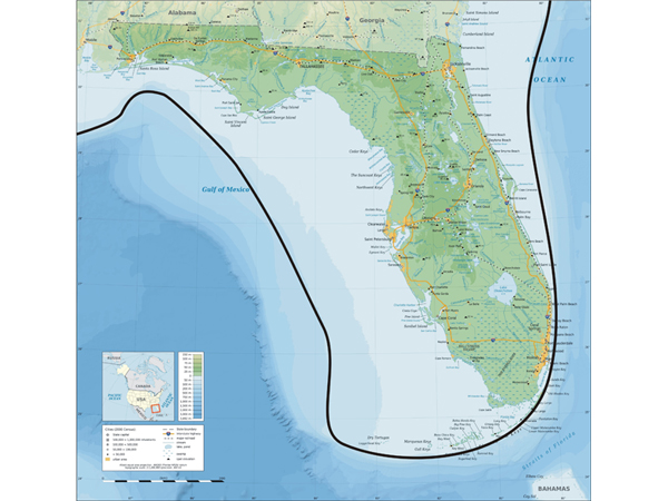
I did request sonar surveys of the continental shelf, but although they have surveyed the outer shelf, they have not surveyed the shoreline shelf. I was looking for undewater Bays, on the shelf.
R
Ralph,
Detailed bathymetry data are available for the whole continental shelf, much of it at sufficient resolution to find larger “bays”.
https://maps.ngdc.noaa.gov/viewers/bathymetry/
In reply to David’s comment.
David: Quote from above.
An air burst bolide that causes shock waves and 3200C burns on the surface of the earth are very, very rare and do no happen in the same region again and again.
How many of the Carolina Bay structures show evidence of the high temperature burn material? I am trying to get a picture in my mind of the relative locations of the sites where burn material was found. Is there evidence of repeated shock waves and high temperature burning in that region?
A confirmation that the majority of the Carolina Bay structures contain burn material would be interesting as it provides a strong hint as to cause.
What stuff are you assuming fell from the sky and was buried in the Carolina Bays, 12,900 year ago? What is the stuff that is found in the Carolina Bay structures that cannot be explained?
My believe was that the Carolina Bay structures were dated 27ka to 100ka as you stated above.
Firestone paper quotes
There’s nothing about the Carolina Bays that can’t be explained without invoking an impact. My point was that even if Firestone’s findings were accurate, they don’t constitute evidence that the bays were impact craters.
Haynes studied the same samples as Firestone and didn’t find what he claimed to have found.
>>An air burst bolide that causes shock waves and 3200C burns on
>>the surface of the earth are very, very rare …. How many of the Carolina
>>Bay structures show evidence of the high temperature burn material?
It would be nice to know. But because the idea that the Bays are impact craters has been so comprehensively dismissed, nobody has bothered to look. Firestone found a vitrified wood sample – but is that sample unique or common? We do not know.
It has been claimed that bolides could not heat the surface to such a degree. But this would have been a unique event where a million secondary slush-ball projectiles would have reentered the atmosphere at the same time. The sky would have been lit up with thousands of 4000 degree projectiles, and one would expect that the result of these high temperatures would show up in the Bays. If it does not, then that is a mark against the impact crater theory.
It would also be nice to learn the dynamics of ice reentry projectiles, and the type of impact crater they might leave. But when asked for further information, a high energy impact lab declined to investigate, saying it was speculative nonsense. So we do not know, because nobody wants to know.
Ralph
Ralph,
The gross-scale phase diagram doesn’t apply to the actual biological situation. Cellulose is carbon plus oxygen and hydrogen (C6H10O5). Firestone relied upon the only actual experimental evidence which he had, which was totally inappropriate to the case at hand.
For instance, the triple point of CO2 is different from carbon, as it water’s from oxygen’s.
I will look at that again. Of course the phase diagram of CO2 will be different, as it is a completely different chemical. But the vitrified material is pure carbon – it is not CO2, and nor is it cellulose. So the phase diagram for pure carbon should apply to these samples..
I will look at this again.
R
Read Firestone et al., 2007 again, the PNAS paper, particularly the section about glass-like material and pine.
Ralf,
The allegedly vitrified C came from cellulose, so the tree had to have burned before later reaching the temperature to vitrify C. So for Firestone’s hypothetical heat blast wave scenario to work, air hot enough to have set the tree ablaze would have to have preceded the superheated front. Thus, the air hot enough to burn but not to vitrify the carbon in the cellulose would have surrounded the whole tree, burning it on all sides before the supposed following even hotter air arrived to blow away all the air.
Firestone’s conjecture fails the physics test.
That’s probably why it wasn’t included in Firestone et al., 2007. As low as PNAS’s standards are, they appear to be head & shoulders above Journal of Cosmology.
>>Those who do carbon dating for a living know how to calibrate
>>to calendar years and avoid or look for possible contamination
You would have thought so. But please show us a C14 calibration curve that includes the YD spike. I think they regard this increase as transient and local, so it does not appear on calibration curves.
I would be genuinely interested if you can so us an example.
Ralph
You can see the phase diagram for carbon below. At normal atmospheric pressure, it would take about 4,000 degrees c to melt carbon and form vitrified wood. Now no forest fire can ever get to those temperatures, and nor can lightning (because wood is wet). This must have been caused by radiant heat, and the most likely cause would be the radiant heat from a (slush-ball) meteor.
Ralph,
As has been repeatedly pointed out to you, the alleged samples of “vitrified” wood supposedly found in the bays are far too young to date from the YD.
You also don’t need 4000 degrees C to melt carbon. Firestone’s own words, quoted above:
“Glass-like carbon can be produced by the thermal decomposition of cellulose at 3200 °C (Kaburagi et al. 2005) but such high temperatures would normally consume the entire tree.”
Usually but not always. In a forest firestorm, anoxic conditions occur when the fire uses up all the O2 available. It’s entirely possible, indeed predictable, that situation will arise in which only one side of a tree will suffer combustion at high temperature, especially if the unburnt side is particularly wet.
In forest firestorms, temperatures exceed 1,100 °C, but the maximum is unknown. Firestone cites Kaburagi, et al, but their cellulose research wasn’t on trees:
https://www.researchgate.net/publication/244318093_Thin_graphite_skin_on_glass-like_carbon_fiber_prepared_at_high_temperature_from_cellulose_fiber
The texture and structure of the glass-like carbon fibers prepared by simple heat treatment at 3200 °C from cellulose fibers were examined by focusing on those of their surfaces. The first order Raman spectra were measured for some of single filaments of the carbon fibers at room temperature in air using a 514.5 nm line of an argon ion laser. Negative magnetoresistance was observed at 77 K for the 3200°C-treated carbon fiber. It was concluded that a glass-like carbon fiber with graphite skin could be prepared from commercially available cellulose-based fiber by a simple heat treatment at 3200°Cc.
Sadly typical of Firestone’s “research”.
>>You also don’t need 4000 degrees C to melt carbon.
>>Firestone’s own words, quoted above:
A phase diagram is a phase diagram. I am not sure about Firestone’s source, but you ‘canaea change the laws of physics, captn’.
R
>>the alleged samples of “vitrified” wood supposedly found in
>>the bays are far too young to date from the YD.
It is a while since I have read this research, but I am pretty sure that some of the carbon dates were so contaminated, that they gave dates in the future (after 1950). I aam not sure if the idea of meteoric contamination is correct, but the results did suggest that the dating process was unreliable.
R
Ralph,
1) I guess I didn’t make my point clear enough. The melting point of compounds, especially more complex molecules, like cellulose, are different than for the elements of which they consist. I would have thought that this was obvious, given the example of water v. O and H. It’s not just the rules of physics, chemistry and biology, but an observation of nature.
2) Do you really imagine that every single sample was contaminated? They were all found to be much younger than the YD. And why do you suppose that some samples from the bays showed no sign of fire, while others did, if they all those of similar age got there during the alleged impact?
I did not see your comment above.
Yes, the phase diagram will be different for different chemicals, but the vitrified material is pure carbon, not cellulose, so the phase diagram for carbon should apply.
I will look further at this.
R
Not according to Firestone et al., 2007. Most of the wacky stuff is from Firestone’s solo 2009 paper.
>>Do you really imagine that every single sample was contaminated?
If the samples were close to the source of the contamination, then yes. It is widely acknowledged that there was a large C14 increase-anomaly at the start of the YD. For what reason, is still open to debate. (Firestone etc blamed the meteor impact.).
So it is possible that this anomalous increase in C14 is the reason why the Bay samples give such wildly innacurate C14 dates. (Most C14 calibration curves do not take the YD C14 spike into account.)
High C14 concentrations at the YD onset…
https://risweb.st-andrews.ac.uk/portal/en/researchoutput/north-atlantic-reservoir-ages-linked-to-high-younger-dryas-atmospheric-radiocarbon-concentrations(27777901-8107-4463-be58-6b6b186a5bd2).html
It would have to have been incorrect differently in each sample by the exact degree to put the corrected, calibrated calendar years all at 12.9 ky.
It would also mean that every other 14C dated piece of wood and bone from 685-8,455 14Cyr BP, also dated exactly to 12
9 cal yr BP… Which would leave about 8,000 years of the Holocene devoid of fossi wood & bone.
Ralph,
Those who do carbon dating for a living know how to calibrate to calendar years and avoid or look for possible contamination.
White pine samples found in Carolina Bays are from various sites and most don’t show any burning at all. This fact alone falsifies the impact conjecture, as do all other relevant data.
The supposition cannot exclude the null hypothesis, as observations don’t require a catastrophic explanation.
>>Those who do carbon dating for a living know how to calibrate
>>to calendar years and avoid or look for possible contamination
You would have thought so. But please show us a C14 calibration curve that includes the YD spike. I think they regard this increase as transient and local, so it does not appear on calibration curves.
I would be genuinely interested if you can so us an example.
Ralph
>>It would have to have been incorrect differently in each sample by the
>>exact degree to put the corrected, calibrated calendar years all at 12.9 ky.
If you look at the sampling, they took the OLS samples from different strata, so of course they will all have different dates.
Question is, why did they not take sample all the way down the core?. My guess is that the research was done on the cheap.
Ralph
David,
This is more interesting than I thought.
I believe I understand the point of this article which was to disprove the impact hypothesis for the Carolina Bay structures.
You have done that. You have won. You are smart. You are correct in that the 500,000 Carolina Bay structures were not cause by air bursts. The Firestone assertion is not correct. That is trivial, however.
There is evidence of high temperature burn residue in some of the Carolina Bay structures.
You have not however explained what caused the 500,000 Carolina Bay structures. What causes their overlapping nature? Orientation of the major axis? Elliptical structure?
If you want to look for the physical cause of what is happening to create burn marks on the surface of the earth, that is an all-in problem.
I find it interesting also that all of the 18 YD sites have very, high temperature melt materials and more importantly that 7 of the 18 high temperature Younger Dryas high temperature melt sites are clustered in the same region where the Carolina Bay structures,
The clustering of 7 of the 18 YD very, high temperature melt material sites in the Carolina bay structure region is very, very, odd.
It looks as if there are certain locations on the earth were the high temperature burning happens more often.
It is almost statistically impossible that there would be air bursts (all dated at 12,900 years ago) which burn the earth but do not leave impact craters at 18 different latitudes on three different continents, with a cluster around of 7 sites with very high temperature residue, in the Carolina bay area.
As I stated, an air burst that burns the earth, 12,900 years ago, does not explain the concurrent change to the geomagnetic field (largest increase in C14 in the record) and abrupt cooling within a decade and cooling for 1200 years.
It is interesting that the elliptical structures (bays) are also found on Long Island. This is evidence that what every cause the elliptical structures that have a consistent orientation of the major axis of each ellipse and an overlapping nature, happens again and again.
https://pdfs.semanticscholar.org/536f/9d1b0e34422b8270bcce33ef0fe6ac68cfec.pdf
William,
Just like the vast majority of “bays”, “basins”, playas” and other such features, the Long Island depressions aren’t oriented toward Saginaw Bay.
This my comment which was included by error in the above quoted material.
There is a concentration of 7 of the 18 Younger Dryas dated sites, in the same region (see map in the pnas content supplement) as the Carolina Bay structures which all show evidence of very high temperature produces and products that are produced in a high strength magnetic field.
Looking at some LIDAR pictures of the Carolina bays I notice that overlapping ellipses have less eccentricity then the covered ones. Is this investigated in a systematic way? If so and there are no exceptions this could support the impact theory.
If found invariably true, that would only further falsify the impact conjecture.
Overlapping bays, as noted, are younger than underlying ones and oriented differently. Geologic, hydrologic and meteorological conditions changed during the course of the Wisconsin glaciation. Thus different shapes and orientations would be predicted for different times.
There is no valid evidence supporting an impact origin for the bays.
>>If found invariably true, that would only
>>further falsify the impact conjecture.
Actually, it would tend support the impact theory.
The first slushballs to arive on the eastern seaboard would have a different trajectory to the later ones. The later ones having a high ‘lob’ trajectory. Since the shape of the resulting crater depends upon the angle of the incomming projectile, the later Carolina Bays are likely to have a different shape.
R
Ralph,
It doesn’t and can’t support the baseless conjecture and wild speculation, since, as noted repeatedly, the overlying bays are younger than the later ones, not by seconds or minutes, but by thousands of years.
And the rims of the overlying bays formed over 10’s of thousands of years and indicate that the overlying bays migrated from SE to NW during Late Pleistocene interstadials.
Only one overlapping bay with higher eccentricity than the underlying one would falsely the impact theory.
They all falsify the impact fantasy.
Here are bays from Robeson County, NC showing a variety of eccentricities, some nearly circular, other more oblong and some stretched to an elliptical extreme, overlapped with those of differing eccentricities. Also a wide range of sizes.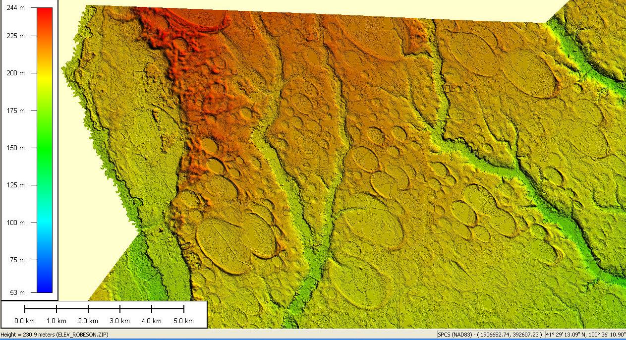
Dunno if this area has been studied for correlation between eccentricities and ages.
>>as noted repeatedly, the overlying bays are younger than
>:the later ones, by thousands of years.
And still nobody has answered my question.
A sand layer contains carbon samples C14 dated to 25,000 BP. A huge slushball roars out of the NW and lands on the region, creating a Carolina Bay, and lodging the carbon sample in the Bay rim. Following this event, what will be the C14 date of the carbon sample? 25,000 BP, perhaps? So is the freshly created rim 25,000 years old?
A sand layer contains sand samples OSL dated to 25,000 BP. A huge slushball roars out of the NW and lands on the region, creating a Carolina Bay, and lodging the sand sample in the Bay rim. Following this event, what will be the OSL date of the carbon sample? 25,000 BP, perhaps? So is the freshly created rim 25,000 years old?
So what is the answer. David Middleton used an old devious trick to not answer the question, saying that the sands had been luminescent dated, not thermoluminescent dated. But we all know that this simply means he has no answer.
But what is your considered opinion?
If we move on 13,000 years from this impact event, what will be the date of the carbon and sand samples? Will they show 13,000 years, or 38,000 years…?
Ralph
I’ve answered that question at least twice. You keep converting optically stimulated luminescence (OSL) into thermoluminesence and ignoring the fact that OSL gives you the age at which a sand grain was buried.
At Herndon Bay an OSL sample was extracted from the lower 1/3 (roughly) of 3 of the 4 rims. This is clearly marked on the core cross section you continue to ignore.
>>They all falsify the impact fantasy.
Ahh, David Middleton proclaiming his faith once more – having left science behind long ago.
R
Herndon Bay is actually a “young Carolina Bay”…
>>Herndon Bay is actually a “young Carolina Bay”…
And so David Middleton has deliberately tried to dodge my question once again. Dodging once might be excusable, but dodging twice simply makes one look foolish.
So I ask again – in the scenarios given above, would the Bays appear to be 13,000 years old, or 38,000 years old…?
It is a simple question.
Ralph
I’m replying through the comnent dialogue ap on my phone. So I’m not sure what scenario you are referring to.
OSL gives you the date at which a quartz crystal was last exposed to sunlight. The OSL dates for the Herndon Bay rims from inboard to outboard were 27, 29 and 36 ka. That means that the sample from the outboard rim (HB4) was buried by overlying sand about 36,000 years ago. HB2 was buried 29,000 years ago and the inboard rim (HB1) was buried about 27,000 years ago.
In the post I provided a link to Utah State University’s OSL lab, which has a fairly detailed explanation of optically-stimulated luminescence dating.
>>At Herndon Bay an OSL sample was extracted from the lower 1/3
>>(roughly) of 3 of the 4 rims. This is clearly marked on the core cross
>>section you continue to ignore.
Indeed. So these so-called ‘scientists’ are dating the sand layers that were deposited there long before the impact disturbed the terrain. They are dating the deposition of the sands, and not the disturbence of the sands, via a slushball impact.
In my example above, they are declaring 38,000 years old, when the impact was clearly 13,000 years ago.
It is a crying shame that modern science has degenerated into a faith….
Ralph
What part of this is unclear?

Rim HB4 was deposited 36 ka.
Rim HB2 was deposited 29 ka.
Rim HB1 was deposited 27 ka.
There’s no indication that anything disturbed the sands in the past 27,000 years.
ralfellis May 5, 2018 at 2:52 pm
Please explain why the sand rims of Carolina bays date from tens of thousands of years apart, yet are supposed all to have been tossed up at the same time, at a date younger than all of them.
Sorry, but you are clearly a hopeless case. No amount of real science can possibly dissuade you or your blind religious faith in an impact that clearly did not make the Carolina bays.
>>OSL gives you the date at which a quartz crystal was last
>>exposed to sunlight. The OSL dates for the Herndon Bay rims
>>from inboard to outboard were 27, 29 and 36 ka.
Indeed – OSL dating is giving you the date at which the sands were deposited, some 30,000 years ago.
What it is not giving you, is the date that the muds below the sands were deformed by a huge slush-ball slamming into the ground. There is no OSL reset, upon a large compression from above.
As to the different dates, you will note that the OSL samples were from different sand strata, so they will indeed give different dates. Why they did not take samples throughout the core, we will never know. One presumes that this research was done on the cheap.
Ralph
The “muds” are the Cretaceous Black Creek Group. It is rock. It is a shaley member of the Cretaceous Tar Heel Formation. They are well known for a wide variety of Cretaceous fossil.
The rims lie unconformably on the relatively flat surface of the Black Creek Group. 27-36 ka unconsolodated fine to coarse grained sands are lying directly on top of a >65 Ma (million year old) shale formation.
Apart from erosion, there is no evidence that either the Pleistocene sandy rims or the Black Creek Group have been deformed.
The rims are composed of totally different material than the “muds”. They are progressively older from the inboard to the outboard rim…
>>the rims lie on a flat surface.
Except the underlying muds are not flat at all. If you look at the elevations of the (white) mud layer, you will see that the rim topography is actually formed by the lower muds, not the upper sands.
http://oi64.tinypic.com/29bbp89.jpg
Your ignorance of GPR processing doesn’t have any relevance to the surface of the Black Creek Group (the mud facies)
There is less than 1 m of relief at the top of the mud facies. From HB1-3 a (400 m horizontal distance) from HB3-4, the top of the mud facies rises about 1 m over a 75 m horizontal distance.
It is relatively flat, particularly in comparison to the surface of the rim sequence.
There is no evidence of any deformation… Just evidence of erosion below HB1-3.
Your diagramatic cross section bears no relation to the radar cross section whatsoever. So why the difference? And which is correct…?
I just explained it in detail to you. Nothing is diagrammatic. GPR transects are not recorded in depth. They aren’t recorded from a common datum. They aren’t geologic cross sections…
GPR data are acquired in time, not depth. The data are recorded and processed relative to the ground surface. In order to present the GPR transect as something resembling a geologic cross section, it has to be surface normalized or topographically corrected.
The cross section from the cores is an accurate geologic cross section. It shows you, in depth, exactly where the top of the Black Creek Group is.
The surface normalized GPR transect is an accurate GPR profile. It provides some indications of stratigraphic surfaces within the rim complex, particularly clinoforms. But it doesn’t tell you anything about the structure of the underlying Black Creek Group. Furthermore, the depths on the GPR transect are gross approximations. GPR data, like seismic data, are recorded in time, The GPR data were converted to depth using a single velocity. The 300 ms recording window is anywhere from 5 to 9 meters.
While they are related to one another, they aren’t the same thing.
Was there a point buried in that world-class wordburger? Asking for a friend.
Who’s the friend?
.
You will note here that we have the standard ‘science by deflection’ that we see in climate ‘science’. The proponents will come up with a series of evidences, which sort of sound reasonable – the Carolina Bays are therefore aeolian. But as you chip away at the evidences, one by one, nothing will deter the faith of the believers.
They shout:
There was no ice sheets where the Carolina Bays point to. So you need to explain that the Bay ‘slushball’ projectiles actually came from the Great Lakes region.
Then they shout:
The Carolina Bays do no point at the Great Lakes. Then you point out that you need to take into account coriolis and lateral impact drift, which they have never heard of.
Then they shout:
The coriolis is backwards. Then you need to explain that they have misunderstood how coriolis works, and the projectiles that made the Carolina Bays do indeed triangulate upon the Great Lakes.
Then they shout:
There was no ice near the Great Lakes 12,800 years ago. So you show maps with ice over the Great Lakes region at that time.
Then they shout:
The dates are wrong. So you need to patiently explain that OSL dating is not reset by an impact, so they are merely dating the era when the sands were deposited, not when the Bay craters were formed.
Then they shout:
Impacts only create circular craters. So you show them examples of low-angle impact elliptical craters – to which the answer is: ‘yeah, but…’
Then they shout:
There is no extraterrestrial evidence, like microdiamonds or carbon spereules in the Bays. So you explain that a projectile made of ice will not form microdiamonds or carbon sphereules.
Then they shout:
But you said thermoluminescense, instead of luminescence. So you explain it is more or less the same principle, and that a mistake is not evidence.
Then they shout:
There is no evidence of radiant burning from reentry projectiles ‘burning’ at 4,000ºc. So you show evidence of vitrified carbon, which required 4,000ºc to melt the carbon (according to the phase diagram).
Then they shout:
A 4,000ºc shock wave would melt any reentry slushball. So you need to explain that water has poor conductivity and high latent heats of melting and vapourisation, so sublimating ice is actually very difficult. Plus the shock wave never touches the slushball, just as it never touches a rocket reentry capsule (otherwise it would melt).
Then they shout:
This vitrification was by a lightning strike. So you ask for any other case of lightning vitrifying wood, and none is forthcoming. (It needs a more sustained burst of radiant energy, to vitrify wood.)
Then they shout:
There are no Bays in central N America. So you show them the Bay formations in Kansas and Nebraska, to which they reply ‘they are not real Bays, real Bays come from Carolina…’
Then they shout:
They Bays are of different shapes. So you explain how the shape of the Bay is determined by the trajectory of the slushball projectile, with the higher lobbed projectiles making a more circular Bay.
Then they shout:
The Bays were aeolian formed, as we can see other examples. So they show examples of ragged misshapen ponds around the world, while the Bays are ‘cookie-cutter’ perfect ellipses.
Then they shout:
There was no mass extinction at this time. So you show a paper by Prof Vance Haynes that says the megafauna extinction (and Clovis Man extinction) were at the start of the Younger Dryas, and took place in less than 100 years. Yes – an instantaneous extinction. To which the answer is: ‘Prof Vance Haynes is stir-fry-crazy’.
.
So all the impact theory bases are covered, and yet they will still believe that the aeolian theory of Bay formation is the only answer. Now while I cannot declare for certain that the Bays are secondary slushball impact craters, it is a theory that has merit and is worth pursuing.
What I can say for certain, is that if we never look for evidence of the Bays being impact craters, we will sure never find it. And so the aeolian proponents will ‘prove’ their theory by direct omission. But that is not real science.
Please see:
The Carolina Bays, and the destruction of North America
http://www.academia.edu/20051868/The_Carolina_Bays_and_the_destruction_of_North_America
Ralph
Ice block melting. Fast forward to 2:15.
Do remember that reentry takes about 4 minutes…
Wind-oriented lakes are common around the World: The Arctic coastal plains of Alaska and adjacent Canada and the Beni Department of Bolivia are two well-known examples. The wind-oriented lakes vary widely in shape and the two examples I mentioned above both tend toward rectangular. The sediments tend to be much wetter where those lakes are forming, and there is no reason to believe the Carolina Bays formed under such wet conditions.
I thought about the conditions under which the Carolina Bays formed. Dating tells us Carolina Bays formed at times of low sea level during Glacial Periods of the Pleistocene. Vegetional history tells us spruce parkland grew in this part of the Carolinas [I am in Horry County, SC] at that time, indicting subarctic and rather dry climatic conditions. The sediments upon which the Bays formed tend to be sandy, at least on the surface. Many are in karstic areas, but many are not. There are many karstic sinks around and they tend to be deep, roundish holes much more like tiny versions of Florida sinks than like Carolina Bays.
I thought about places with similar climatic and geological conditions. My first thought was the coastal plain of southern Argentina. I looked, and, lo and behold, there were similar oval deflation basins, some still flooded and some dry. Look at the are north of Rio Gallegos in Santa Cruz Province, just north of the Straits of Magellan. The Historical images feature of Google Earth allows us to see there are seasonal lakes. They are oriented like Carolina Bays, with the long axis on a NNW SSE axis. They are oval like Carolina Bays, though less elongate and generally less uniform in shape. They are on unconsolidated sediments that appear sandy, like Carolina Bays. They also tend to have aeolian sands deposited along one side (in this case the eastern side). Most of all, they are seasonal and on non-saturated substrates.
I would propose that Carolina Bays formed in a similar environment and in similar fashion. I believe they formed as deflation basins over spots de-vegetated for whatever reason (seasonal drought, megafaunal wallows, or a combination of many different sources). In the basins, seasonal lakes would form during the wet part of the year (presumably spring when the snow melts) allowing wind orientation. In the dry season (presumably summer and/or fall) the basins would dry out allowing deflation of the sandy lake bottom and formation of aeolian rims downwind of the basin.
This would explain the orientation of the Carolina Bays with a NW to SE long axis and a sand rim on the E and NE margin. The predominant wind while flooded during a wet season would orient the lakes – in the case of the Carolina Bays that would be wind from the NE. The predominant wind while empty would determine the location of the sand dune rim. In the case of the Bays that would be a wind from the W or SW. In the Argentinian lakes the orientation and location of the sand rim both suggest a predominant wind from the WSW, but I would argue the Carolina Bays suggest seasonal lakes with predominant winds that shift between the wet season (probably spring when the lakes were full of snow melt) and the dry season (probably summer and fall when a drying wind blew from the W). If the lakes filled before the winter freeze, there might also be ice rim push to further help expand the basins and make the margins more uniform.
This is not a new hypothesis for me but dates back to my days as a paleoecologist and paleolimnologist (I worked on African Lakes for the most part – but could never ignore such an interesting set of lake basins so close to home!). I have observed Carolina Bays most of my life, and the bolide impact theory never sat well with me. The Bays are restricted to upland soils and margins of river bottoms – if they originated as bolide craters they would be as likely to appear inside the river bottoms and on the Piedmont, where they are absent. Further, the Bays encroach on and are encroached upon by large, lunate, aeollian dune fields that grew along the eastern margins of the river bottoms, suggesting the processes forming each were active at the same times. The dunes to me suggest a sandy, probably braided river valley (not unlike the Platte River in NE) – also indicative of highly seasonal water availability (as rivers that run high with spring snow melt but low later in the warm season). Finally, those Bays that have been dated to many different times – thousands or tens of thousands of years apart – and occur in nested sets, implying the bays reformed in the same areas multiple times.
Of course my recent discovery of oriented lakes forming in Argentina under similar conditions makes me want to do some field work!
You are correct, sir.
Re Patagonian features, please see above.
No fantastic impact conjectures need apply.
And then they shout out:
……”Antioch Bay, NC… Everything except coordinates:”
Index #: 139316_4578
Location: 34.863239161831586,-79.19532579440423
Major: 0.98 km . . . Minor: 0.67 km
………
…. and they immediately display the metric table, whose 2nd line contains a high-resolution latitude and longitude. Perhaps they are confused by the lack of simplistic coordinates like “Latitude: 34.6º North, Longitude 79.1º West.” Plug [ 34.863239161831586,-79.19532579440423 ] into Google Earth and you will get where you want to go. Its called “coordinates”. If you insist, I will change the pop-up display to less challenging format; as it stands the metrics title “Location” and the display of “lat, lon” without degree sign is as held in the Google Fusion table by their design. But then you would not be able to just plug it into Google Earth. Not that you need to, the KMZ linked on the page will take you there with LiDAR and all, but you do need to use Google Earth. Is that bad science???/
I have been perusing this for a while this morning, seeing the confusion wrought when several conflicting hypothesis are overlaid, where any valid falsifications found in one are applied to the others…. This is similar to why it took 50 years of caustic debate to “discover” that things bigger than 20 ft in diameter ever hit the Earth. The senior uniformitarian Carolina bay investigator was Dr. Douglas Johnson, the Executive Officer of Columbia University’s Department of Geology. He wrote the only scholarly-level book about the bays, published by Columbia University Press in 1942. In 1940 he published an article in a book from Yale University Press, where he soundly defeated any such nonsense with an incontrovertible fact:
“The largest meteorites known to have reached the earth measure less than a score of feet in maximum diameter”
Were catastrophic solutions given a fair hearing? Dare I say “banished”?
What I am most hopeful regarding this conversation is that it FIANLLY puts to bed any and all association between the YDB debate and the formation of the Carolina bays. But it won’t; I’ll be bearing that cross for another 10 years.
I am also pleased that the dialogue has included some great observations about the crisp planforms of the bays and how those “similar” gradualistic landforms across the globe (Alaska, Greenland, Chile, Australia) can’t hold a candle to them – the pretenders all exhibit a rag-tag assortment of shapes, and the vast majority present no true ovate shape around their entire circumference. Carolina bays DO. I’ve measured tens of thousands of them and they are all there to look at using Google Earth. Or not, if you are inclined to base your knowledge on a belief system.
My latest on-line presentation is based on the 2017 AGU Presentation: http://mptImpact.org