Guest Post by Willis Eschenbach
I’ve been thinking about temperature and top-of-atmosphere (TOA) forcing. TOA forcing is the imbalance between the TOA upwelling and downwelling radiation. The CERES satellite dataset contains observations of the TOA radiation imbalance on a gridcell-by-gridcell basis. It is calculated as the downwelling solar radiation for that month by gridcell, minus upwelling reflected solar radiation, minus upwelling longwave radiation. Figure 1 shows the distribution of the TOA radiation imbalance around the planet.
 Figure 1. Average top-of-atmosphere (TOA) imbalance.
Some areas in Figure 1, such as those around the tropics, absorb more radiation than they emit (positive values). The extra-tropics and the poles, on the other hand, emit more radiation than they are absorbing (negative values). The balance is maintained by the constant transfer of heat between the tropics and the poles by means of the ocean and atmosphere .
We can also take a look at the amazing stability of the net TOA radiation over time. Figure 2 shows the month-by-month changes in the global net TOA radiation.
 Figure 2. Decomposition of the net TOA radiation into the seasonal and residual components. Top panel shows the raw data, the observed monthly changes in the net TOA radiation. The middle panel shows the seasonal component, i.e. the average values which repeat every year. The bottom panel shows the observed data minus the seasonal component. Blue line shows the gaussian smooth of the raw data. Dotted horizontal gold lines show the standard deviation of the residuals.
The annual swings in the net TOA radiation are the result of the earth moving nearer to and further from the sun. As one might expect in a responsive system, the change in net TOA radiation is considerably smaller than the change in the solar radiation. When the downwelling solar radiation varies, the variation is partially counteracted by changes in the upwelling longwave and shortwave.
As mentioned, the net TOA radiation is also remarkable for its stability (bottom panel, Figure 2). The standard deviation of the global imbalance in net TOA radiation is about six-tenths of a watt per square metre (dotted horizontal gold lines). Note also that over the fourteen-year period there is no trend in the net TOA radiation.
With all of that as prologue, let me move on to my latest peregrinations through the CERES satellite dataset. I decided to take a look, on a gridcell by gridcell basis, at the relationship between the net TOA radiation imbalance and the surface temperature. It is often useful to look separately at the land and the ocean. Figure 3 is a scatterplot of the net TOA radiation versus the surface temperature, by gridcell, looking at just the ocean data.
 Figure 3. Annual averages, ocean temperature versus net TOA radiation imbalance, ocean only. Blue dots show individual ocean gridcells. Red line shows a loess smooth of the data. Areas below freezing are ice-covered ocean. Dotted black horizontal line shows 30°C, which is the approximate maximum open ocean average temperature. A positive net TOA value shows that incoming solar is greater than outgoing solar + longwave.
As one might expect, there is indeed a relationship between the sustained TOA imbalance and the temperature. And as one might also expect, increasing net TOA radiation is associated with increasing temperature. However, the relationship is far from linear. Instead, it varies with the temperature.
Temperature response to forcing is largest at temperatures below freezing (steeply increasing red line at left of Figure 3). Above freezing the temperature response is roughly linear up to about 20°C or so. Above about 20°C, the temperature becomes less and less responsive to increasing radiation (leveling off of red line at top right of Figure 3).
Note that in fact, we should expect this pattern. This is in part because for any heat engine, in general parasitic losses go up as some increasing function of input energy. A car is a good example. If you double the amount of gas it’s getting, you don’t get twice the speed. Similarly, we’d expect a decreasing temperature response as the input energy continues to increase. I’ve previously shown that parasitic losses (sensible and latent heat losses from the surface) increase with temperature in a post entitled Marginal Parasitic Loss Rates.
As I mentioned above, the relationship between TOA radiation imbalance and surface temperature over the ocean is far from linear. But that non-linearity pales compared to the situation over the land. Figure 4 shows that situation.
 Figure 4. As in Figure 3, but for land only.
That’s about as non-linear as I can imagine. Note how there seems to be some kind of upper limit on land temperatures regardless of the TOA imbalance. Now, some of the non-linearity comes from altitude, since the higher you go the colder it gets. The very cold data at the bottom of Figure 4, for example, comes from the high plateaus of Antarctica. However, adjusting for altitude at a nominal rate of 1°C per hundred metres of elevation only solves part of the problem. Figure 5 shows the same data used in Figure 4 after adding one degree per hundred metres of elevation.
 Figure 5. As in Figure 4, but with the temperatures adjusted for elevation by adding one degree C for every hundred metres of altitude. Note the different scale from Figure 4.
As you can see, although this is a crude adjustment method, it brings Antarctica much more into line. However, it doesn’t change what’s happening up at around 30°C. Just as in the ocean, at the top end the land temperature is pretty much decoupled from the radiation imbalance.
Conclusions? I don’t have a whole lot of them. This is all part of my continuing effort to understand this marvelous and mysterious climate system. The one solid conclusion is that the relationship between forcing and temperature is both non-linear and temperature dependent, with the temperature response generally diminishing with increasing temperature. My other conclusion is that given the significant lack of linearity, any average value for the relationship between TOA radiation and temperature is bound to be both misleading and meaningless.
Best regards to all,
w.
My Usual Request: If you disagree with someone, please quote the exact words you disagree with, so that we can all understand the precise nature of your objection.
the land response in figure 4 follows the ocean response in Fig 3, until Fig 4 gets outside the ocean range (-20 to 30).. Then it shows quite a different trend.
I can’t see the reason to “correct” for altitude, except to try and explain away the different response curves at the limits. More than anything this may simply serve to hide the difference between land and ocean response.
Willis,
“TOA forcing is the imbalance between the TOA upwelling and downwelling radiation.”
Actually, that is incorrect. Forcing is the imbalance that would occur in the absence of any response from the climate system. One way of estimating forcing in climate models is to make an instantaneous change in some property, such as CO2 concentration, then examine the modeled TOA flux imbalance as a function of time. That latter quantity changes as the model comes to a new steady state. The forcing is obtained by extrapolating the TOA flux imbalance back to the time of the change.
The present best estimates for anthropogenic forcing and TOA flux imbalance are, respectively, 2.3 and 0.5 W/m^2. Different quantities.
Using scientific terminology consistently minimizes confusion, even if the terms are bad ones.
Note also that over the fourteen-year period there is no trend in the net TOA radiation.
What another data set with no trend? Perhaps this should be added to the regular updates of temperature records with no trends for given periods of time? Why restrict the list to just temperature? It isn’t even temperature we should be trying to measure as it doesn’t vary linearly with energy flux anyway. It is energy balance that we ought to be focusing on in the first place.
But I note SkepticGoneWild’s comments above. There are very large fudge factors in the CERES data. But hey, if they say there’s no trend for the last 14 years, and that agrees with RSS and UAH, who am I to disagree? Let the alarmists explain it.
The problem with looking at yearly top of the atmosphere data is one can get lost in the weeds.
A different approach to crack the puzzle what causes cyclic warming and cooling and abrupt cyclic cooling and warming (glacial/interglacial cycle, the start and end of the interglacial periods, Younger Dryas like abrupt climate change which are called Heinrich events, and the more gradually warming and cooling cycles that are called Dansgaard-Oescgher cycles) is to look at what has happened in the past (recent, last 14,000 years, and last 420,000 years), then look at what is happening and did happen in the recent record. This is holistic analysis as opposed to fractional analysis.
Ask yourself why is there no holistic climate analysis? What is stopping holistic analysis of this problem? The last person to do holistic analysis has Michael Faraday (See diary, 1868) or perhaps Wagner which lead to the tectonic plate breakthrough in geophysics.
I am serious. I am working on book. Could someone help me out, why is holistic analysis not done? What is the dang barrier to holistic analysis? Why do people not summarize the data at a high level? Why are paradoxes and anomalies ignored? Why do people develop theories/mechanisms that are not supported by the paleo data? Such as CAWG?
Holistic means one looks at all of the data at the same time. What is the data telling us? Summarize in words what the data is telling us at a high level.
What is likely, possible to happen next based on what happened in the past? What are the current trends? I am again asking a serious rather than a rhetorical question. I am working on a book, about these subjects, barriers to breakthroughs, holistic analysis, what causes the glacial/interglacial cycle, and how the sun is different that the standard model.
Last 420,000 years
Look at the below graph. Smooth gradual changes or sharp changes? The data indicates Interglacial periods start and end abruptly. The data supports the assertion that there is a massive forcing function that causes the planet to abruptly warm for a short period of time (less than 12,000 years) and then abruptly cool for 100,000 years (massive ice sheets cover Canada, Northern US States, the UK and Northern Europe).
http://cdiac.ornl.gov/trends/temp/vostok/graphics/tempplot5.gif
The alternative to the massive forcing function (Hint: The massive forcing function is the sun) is the tipping point hypothesis. The tipping point hypothesis, is an urban legend that the earth’s climate can jump from one state to another moved by a tiny forcing function. There is no analytical data to support the tipping point hypothesis. The earth’s climate does not ring, wildly oscillate when there is a massive temporary step change caused by a super volcano eruption. The tipping point hypothesis is one of the many urban legends that have filled the theoretical void.
A theoretical void is when the cause of something is not known. Urban legends are theories that are sciency sounding and are repeated over and over again, with a side comment that they are ‘part’ of the solution. In reality urban legends block the solution of the puzzle as they avoid clearly labeling the paradox and noting there is no solution, as of yet.
Temperature Last 11,000 Years
Greenland ice temperature, last 11,000 years determined from ice core analysis, Richard Alley’s paper. William: The Greenland Ice data shows that have been 9 warming and cooling periods in the last 11,000 years. There was abrupt cooling 11,900 years ago (Younger Dryas abrupt cooling period when the planet went from interglacial warm to glacial cold with 75% of the cooling occurring in less than a decade and there was abrupt cooling 8200 years ago during the 8200 BP climate ‘event’).
http://www.climate4you.com/images/GISP2%20TemperatureSince10700%20BP%20with%20CO2%20from%20EPICA%20DomeC.gif
There is cyclic warming and cooling in the current interglacial period the Holocene. There is also one Heinrich event in the Holocene. That Heinrich event is called the Younger Dryas.
There are peer multiple peer reviewed papers that discuss abrupt cyclic climate change. The fact that it is cyclic supports the assertion that the sun is the forcing function. Earth systems are chaotic and are not regular. The cycle is caused by the large planets which move the sun about is center. When they are aligned to cause a rapid change in motion of the sun oscillation are caused which disturb the solar tachocline region which in turn causes an abrupt change to the sun.
There are peer review papers that discuss the correlation of cyclic solar events with it movement changes by the large planets. There are peer reviewed papers that predicted the current abrupt change to the solar cycle.
http://sheridan.geog.kent.edu/geog41066/7-Overpeck.pdf
http://www.agu.org/pubs/crossref/2003/2003GL017115.shtml
http://wattsupwiththat.com/2012/09/05/is-the-current-global-warming-a-natural-cycle/
Distribution of water vapor coincides with the temperature.
Of course, the current AIR temperature.
http://earth.nullschool.net/#current/wind/isobaric/850hPa/overlay=temp/equirectangular
The actual range of snow and ice. Visible beginning of the EL Niño.
http://weather.gc.ca/data/saisons/images/2015050900_054_G6_global_I_SEASON_tm@lg@sd_000.png
William M. Gray ?w=640
Professor Emeritus
Colorado State University
The model simulations have followed the unrealistic physical ideas emanating from the National Academy of Science (NAS), 1979 (or Charney Report). This report speculated that as the troposphere warms from CO2 increases that this warming would be accompanied (follow the Clausius-Clapeyron relationship between temperature and moisture) by a moisture increase such that the relative humidity (RH) of the air would remain near constant as the temperature increased. Implicit in this NAS assumption of CO2 induced warming was the necessity that this increase of moisture would add additional blockage of infrared (IR) radiation to space beyond what the CO2 gas did by itself. The net IR blockage to space from increasing CO2 was thus assumed to occur not only from the CO2 gas itself but also from the extra water-vapor gain needed to keep the RH near constant as the temperature rose. This additional water-vapor gain was shown by the models to have about twice as large an influence on reducing IR blockage to space as the CO2 increase by itself. Thus, any CO2 increase of one unit of IR blockage to space would simultaneously bring along with it an additional two units of water-vapor blockage of IR loss to space. This additional moisture related blockage of IR loss to space (associated with CO2 induced warming) has been designated as ‘positive water-vapor feedback’. All the CO2 climate models have strong amounts of positive water-favor feedback.
It is this large and direct tie of water-vapor increase with CO2 induced temperature rise which is the primary physical flaw in all of the GCM CO2 doubling model simulations. This is the reason why all the GCMs have so strongly over-predicted the amount of global warming which will occur with a doubling of atmospheric CO2.
Observations show that the warming or cooling of the upper troposphere does not occur with RH remaining close to constant. Temperature and RH tend to change oppositely from each other and not in unison as the models assume. My project’s study of cumulus convection and tropical cyclone formation over many decades has taught me that the NAS 1979 (Charney) Report assessment that rising CO2 amounts will occur with water-vapor increase is not a realistic assessment of how these parameters change in the upper troposphere.
The GCM CO2 simulations are also constructed so as to have their moisture simulations arranged such that water-vapor changes occur uniformly at both upper and lower tropospheric levels. By contrast, the observations of moisture change at upper and lower tropospheric levels show them to be little related to each other (Figure 3).
https://stevengoddard.wordpress.com/2015/05/09/dr-bill-gray-explains-why-climate-models-dont-work/
Our project’s many years of analysis of the International Satellite Cloud Climatology Project (ISCCP) observations of IR loss to space in association with enhanced Cb convection and rainfall do not show a decreased IR blockage to space (as the models have indicated will occur) but rather an enhancement of IR loss to space. Our data analysis is, by contrast with the models, representation of a negative water-vapor feedback – the larger the rainfall rate, the lower the upper tropospheric water-vapor content and the greater the IR loss to space (Figure 6).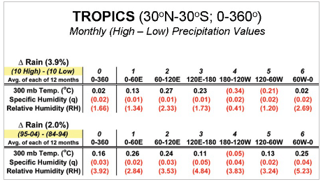 ?w=640
Figure 6. Changes in 300 mb temperature, specific humidity (q – gm/kg), and relative humidity (RH) by area between two reanalysis rainfall difference data sets for the tropics. Rain differences average 3.9 percent for the 10 highest minus 10 lowest monthly differences and 1.9 percent for the (95-04)-(84-94) data set differences. Negative values are in red. All 300 mb moisture parameters showed water-vapor and RH decreases with enhanced rainfall.
“This graph shows in green Hadcrut4 estimates of global surface temperature, including ocean SST, and near surface air temperatures over land. The blue line from RSS tracks lower tropospheric air temperatures measured by satellites, not near the surface but many meters higher. Finally, the red line is again Hadsst3 global SST All lines use 30-month averages to reduce annual noise and display longer term patterns.
Strikingly, SST and GMST are almost synonymous from the beginning until about 1980. Then GMST diverges with more warming than global SST.”
http://woodfortrees.org/graph/hadsst3gl/from:1850/to:2014/mean:30/plot/hadcrut4gl/from:1850/to:2014/mean:30/plot/rss/every/mean:30
https://rclutz.wordpress.com/2015/05/10/empirical-evidence-oceans-make-climate/
William Astley May 9, 2015 at 9:47 am Edit
Sorry, William, but I’m not buying the idea that the way to understand the climate is to look at what our scarce, inaccurate proxies say happened nearly half a million years ago.
For me the key to understanding the climate is to look at what happens on a daily basis. I prefer observations and measurements of recent events rather than proxies for ancient events as a basis for my science, but hey, that’s just me. So I’ll leave you to your speculations. Not saying your way is wrong, just saying it’s not for me.
w.
Willis,
I am curious why you believe studying the past is not a guide to what will happen in the future. What has changed to in the earth system that would make it respond differently?
The climate in the past changed cyclically. Why? Do you understand what cyclically means? Something that happens again and again and again. There must be a physical reason for the periodicity and for the climate change.
There are a dozen different logical arguments connected to peer reviewed observations that the sun is the cause of the massive forcing change and that the large planets movement of the sun is the reason for the periodicity of the solar changes which in turn is the reason for the periodicity of the earth climate changes.
The sun changes in a manner that we do not believe is possible to cause the very, very large forcing changes. I will move to the solar thread to explain the new research on neutrinos. The solar neutrino problem has not gone away.
The climate changed cyclically in response to a forcing change and sometimes to a massive forcing change in the past. That is what the data says. The massive forcing function has not gone away.
How the climate changed recently (warming, high latitude warming both hemisphere with slight cooling of the Antarctic ice sheet) matches the cyclic pattern of warming in the past. The sun was in its highest activity state in 8000 years in the last 50 years.
There has been an abrupt change to the solar cycle. Correct?
The high latitude cooling that we have recently observed is a reversal of the warming. Why? What has changed to cause the cooling? The sun.
There are half dozen solar and earth observations that support the assertion that we going to experience a Heinrich event. Something that is capable of terminating an interglacial period.
What we are observing is a sudden increase in sea and the start of cooling in the Southern Hemisphere.
http://arctic.atmos.uiuc.edu/cryosphere/iphone/images/iphone.anomaly.global.png
In 2012 there was the start of a significant increase in sea in the Antarctic for all months of the year. Gradually that was followed by general cooling of the Southern hemisphere oceans.
http://arctic.atmos.uiuc.edu/cryosphere/IMAGES/seaice.anomaly.antarctic.png
http://www.ospo.noaa.gov/data/sst/anomaly/2015/anomnight.5.7.2015.gif
The thickness of the sea ice in the Arctic has increased substantially. The temperature of the North Atlantic decreases.
http://psc.apl.uw.edu/wordpress/wp-content/uploads/schweiger/ice_volume/Bpiomas_plot_daily_heff.2sst.png
Blizzards in the west and north of US 10 May 2015.
William Astley May 9, 2015 at 1:12 pm says:
Thanks, William. For me, the biggest problem with the idea of studying the past climate as a guide to the future climate is that we don’t understand the present climate …
In addition, while our contemporary observational datasets are spotty and incomplete in time and space … they are orders of magnitude better than using proxies to guess at what happened half a million years ago.
Does that mean “don’t study the past”? By no means. I’m just saying that until we understand the present, all conclusions about the past are provisional.
You also say:
My brother used to say “It’s easy to predict the future … as long as it’s just like the past”. The problem with the climate is rarely just like the past. See the ups and downs and level periods in the recent temperature record.
As to “what has changed”, you’ve put your finger on the underlying problem. For example, the earth generally cooled from the 1400s to the “Little Ice Age” … what changed to make it start cooling? We don’t know. Then something changed, and we came out of the Little Ice Age. What changed to make the globe start warming? We don’t know.
As a result, no, we can’t simply assume that the future climate will be just like the past climate.
Best to you,
w.
Let’s see the current the absorption of solar radiation.
http://www.ospo.noaa.gov/data/atmosphere/radbud/gs19_prd.gif
The daily average global remains at the level 237 W / m ^ 2. Thus it is less than 240 W / m ^ 2.
“Younger Dryas like abrupt climate change which are called Heinrich events, and the more gradually warming and cooling cycles that are called Dansgaard-Oescgher cycles)”
Dansgaard-Oeschger events (not cycles) are abrupt climate changes (=abrupt warming, slower cooling). The end of the Younger Dryas was probably a D-O event of sorts. Heinrich events are suidden irruptions of icebergs into the North Atlantic. Some, but not all, Heinrich events seem to be correlated with abrupt climatic changes, but the connection and mechanism is far from clear. They do seem to occur mostly in the cold spells before D-O events.
In reply to tty,
Your comment is not correct. See the two paper which I have copied from my above comment as you have not read the paragraphs which I quoted that supports my comment (states almost exactly what I said).
Heinrich events are abrupt cooling events. Heinrich events terminate interglacial periods. Look at the graph of planetary temperature for the last 420,000 years. The interglacial periods end abruptly not gradually.
The ice bergs in the North Atlantic are caused by the Heinrich events, the rush of ice bergs does not cause the cooling.
There was an urban legend started that somehow ice sheet ‘instability’ could cause the abrupt Heinrich cooling however detail analysis of ocean sediments (the ice bergs when they melt drop micro rock in the ocean sediments that can be used to determine the origin of the ice sheet from which they came) found the ice bergs came from three separate independent (impossible for the independent) ice sheets.
It is not possible for three independent ice sheets to surge at the same time (climatologist agree on that point) and regardless the proxy evidence showed the oceans cooled first and then there was a surging of the ice sheets.
What every appear to not understand is the Younger Dryas abrupt cooling ‘event’ 11,900 years ago, the planet cooled from interglacial warm to back to glacial cold with 75% of the cooling occurring in less than the decade and the cooling lasted for 1200 years, is a cyclic event. This is what terminates interglacials.
There are not two massive forcing functions. There is one. It is the sun.
http://sheridan.geog.kent.edu/geog41066/7-Overpeck.pdf
ABRUPT CHANGE IN EARTH’S CLIMATE SYSTEM Jonathan T. Overpeck and Julia E. Cole
http://www.agu.org/pubs/crossref/2003/2003GL017115.shtml
“The ice bergs in the North Atlantic are caused by the Heinrich events, the rush of ice bergs does not cause the cooling.”
The ice bergs are not caused by Heinrich events, they are the Heinrich events, which are defined by high IRD levels in the North Atlantic. I’m sorry but Overpeck apparently does not know much about Quaternary Geology.
“Heinrich events terminate interglacial periods.”
No. The last interglacial ended 117,000 years ago. The first Heinrich event (H6) was 65,000 years ago, c. 50,000 years later. And how could an interglacial end in a massive outbreak of icebergs? There isn’t any ice around to calve icebergs during an interglacial.
“What every appear to not understand is the Younger Dryas abrupt cooling ‘event’ 11,900 years ago”
I think you have confused things here. The younger Dryas ended 11,700 years ago. The abrupt cooling that ended the Late Glacial Interstadial and the beginning of the Younger Dryas was about 12,900 years ago.
Willis
“The CERES satellite dataset contains observations of the TOA radiation imbalance on a gridcell-by-gridcell basis. It is calculated as the downwelling solar radiation for that month by gridcell, minus upwelling reflected solar radiation, minus upwelling longwave radiation. Figure 1 shows the distribution of the TOA radiation imbalance around the planet.”
//////
There are many fundamental differences between land and ocean such that on a grid cell by grid cell basis, one would never expect there to be a balance between “solar radiation … minus upwelling reflected solar radiation”
Over the oceans some of the received solar does not go to heat the SST but is rather absorbed at depth. Further, some of the energy received by the ocean in one location is, via oceanic currents, carried to another region where it serves to increase SST in that other location. There is no such equivalent on land.
richard verney May 9, 2015 at 10:04 am says:
Thanks, Richard. I’m not sure who “expect[s] there to be a balance” between upwelling and downwelling radiation in any particular gridcell, but it’s certainly not me … as Figure 1 clearly shows, in general there is always a TOA imbalance in any gridcell or group of neighboring gridcells.
w.
I’m blown away by the fact that the highest surface temp isn’t correlated with the highest TOA.
The appearance of this plot reminds me of your thunderstorm argument for temperature regulation. Can this be called the thunderhead plot? 🙂
Perhaps there is spatial correlation along the 30C line. There is only so much energy to give. Perhaps the low TOA and high TOA cells correlate in space and time and represent convective transport cells which would result in hot and cold spots.
SkepticGoneWild May 9, 2015 at 7:05 am
Thanks, Skeptic. I’m in total agreement with you up until the very last statement. You’re throwing the baby out with the bathwater.
As I have stated a number of times, and as your quote shows, the accuracy of the combination of the CERES instrument data is not that great.
What you are missing is that the instruments are internally quite precise. This difference between accuracy and precision means that while we can’t use the CERES data for measuring the absolute value of the net TOA radiation, the data is very valuable for measuring the variations in the net TOA radiation.
As an example of this difference, suppose your scale constantly gives a weight that is too heavy, but you’re unsure exactly how much too heavy it weighs. You do note, however, that each time you get on and off and on and off the scale over a period of a few minutes, it gives the same answer within ± a half pound.
Can you use the scale to determine your weight? Well, not really, because you don’t know how big the error is.
But can you use the scale to determine if you are gaining or losing weight? Sure, just weigh yourself every day and see which way the numbers go, that is to say it can measure the trend.
Similarly, while the CERES data cannot tell us what the net TOA imbalance is, the data can and does tell us whether it is gaining or losing, that is to say CERES can measure the trend without knowing the absolute value.
Regards,
w.
Willis says, “What you are missing is that the instruments are internally quite precise. This difference between accuracy and precision means that while we can’t use the CERES data for measuring the absolute value of the net TOA radiation, the data is very valuable for measuring the variations in the net TOA radiation”
============================================
Along the lines of learning based on these observation please consider your figure 3 chart, Oceans only,
Would it be possible to do this on a seasonal basis, seeing the difference between the SH summer, when the TOA insolation is most extreme, and the NH summer, when the insolation is lowest? I think that understanding what happens to earth’s energy budget when the ATMOSPHERE cools despite plus 90 watts per sq. meter insolation in the SH summer is informative. How much of that annual atmosphere cooling is due to NH increased albedo, vs. SH increased ocean absorption of surface insolation, which also for a time prevents energy from entering the atmosphere? Understanding how the earth processes the seasonal pulse of plus 90 watts per sq. meter is, IMV, an excellent opportunity to increase understanding of earth’s climate.
I enjoy your comments on how the earth mitigates forcing changes. The seasonal cooling of the global mean atmospheric T where energy is lost to the atmosphere permanently to space via increased albedo, and temporarily via ocean absorption, is perhaps an under used opportunity to learn.
A follow up question if I may. You stated
“Note how there seems to be some kind of upper limit on land temperatures regardless of the TOA imbalance. Now, some of the non-linearity comes from altitude, since the higher you go the colder it gets. The very cold data at the bottom of Figure 4, for example, comes from the high plateaus of Antarctica. However, adjusting for altitude at a nominal rate of 1°C per hundred metres of elevation only solves part of the problem. Figure 5 shows the same data used in Figure 4 after adding one degree per hundred metres of
elevation.
——————————————————————
I do not understand why you did this. The T is what it is, the TOA flux, positive or negative, is what it is. Thanks.
Willis writes “As an example of this difference, suppose your scale constantly gives a weight that is too heavy, but you’re unsure exactly how much too heavy it weighs.”
This is only true while the error is linear. Thats not a given.
Lets suppose for arguments sake that the error depended on cloud thickness which we also weren’t measuring accurately. Now the data really does become useless because you have two unknowns and precise measurements of one doesnt mean anything until you have measurements of the other.
EdA the New Yorker May 9, 2015 at 7:43 am
Thanks, Ed, but it’s not an artifact. It’s a real phenomenon, and is discussed in the literature. See my post Argo and the Ocean Temperature Maximum for more information.
w.
Thanks, Willis. Your posts are always delightfully thought provoking. The trip back to your other post just reinforced my recollection of it. The comment in this post was actually adequate to jog the memory regarding the over ocean data, which sits well in my gut.
My comment was rather specific to your Figure 4, and Nick Stokes’ comment on the a priori belief that TOA radiation imbalance should be independent of surface temperature. Separating this land-only component out from the general data was informative for that reason. The lack of land surface ability to generate water vapor at will deprives it of the theromostatic control available to the ocean. Thus, winds should be quite sufficient to rid any coupling between the surface and the TOA, as Nick indicates.
Your plot shows a distinct correlation, not surprisingly nonlinear, which terminates in a hard topping at 30 C. The reason I posed the question is that I can’t think of any reason for that to happen without significant coupling provided by thunderstorms, and the like, which currently cannot be included in GCM’s. Your Figure 5 just muddies the issue for me, as Antarctica is really a different beast, and shouldn’t be forced to “toe the line.”
Yes, but that applies to the ocean temperature maximum. It is not obvious why a similar “roof” should apply to land temperatures, but apparently it does. This is the more remarkable since there is a large annual temperature swing on land while ocean temperatures in the tropics are virtually constant.
But the annual average seems to be limited to a little over 30 centigrade both on land and at see. Definitely odd.
The non-linearity is due to water phase change non linear behaviour (same water cycle issues you pointed out before). Ice doen’t convect well, but steam condensing more than swamps the needs. So hot enough for thunderstorm formation lids the top end, while the cold end at frozen locks up… But you already knew that…
Are there data showing how much radiation in the wavelength range that is absorbed by CO2 is leaving the atmosphere, and how that changes with time? Does anyone know of references on this matter? CO2 absorbs most of this, and I’m interested to know how much more is escaping in that range.
No-one in the ‘climate game’ is interested in producing data about this. No money in it. You can probably gleen bits and pieces that are mentioned in many papers but you are going to have to search for it.
Essentially most of the radiation that is absorbed by CO2 is removed by collision with other atmospheric atoms/molecules which increases their kinetic energy (speed up/warm up). A cascade effect that eventually escapes out of the atmosphere in milliseconds. Some aspects of this have been laboratory tested but don’t necessarily transfer to the real world. It’s mostly speculation. That is why you don’t have real data. Just models on top of models
A couple of things stand out for me in this data. Firstly, the TOA imbalance has been essentially zero over the period plotted which means there has been no net energy to drive warming and explains why there has been no net warming over that period. Its not a case of the heat flowing into the oceans, there is no excess heat to flow anywhere!!!!
Second, while I agree the slope of the plotted curve is far from linear it is in fact quite close to linear for TOA imbalance close to zero. If I do a linear approximation it shows a slope of about 5 watts/sqM TOA imbalance for each 1 degree change in temperature. Note this is a value with all feedbacks in place since I understand it is a measured value from the environment. Now doubling CO2 yields a change in retained heat of about 2.7 watts.sq/M so doubling CO2 would increase global temperature by about 0.5C. That’s very close to the value most often bandied about by skeptics. Further proof that while some AGW is real and occurring its a very long way from being catastrophic, dangerous or even particularly significant.
As an aside, its interesting to see that this value of 5 watts/sqM per degree C is greater than would be predicted from Planks law (since earth is not a black body radiator thanks to GHG’s). Black body sensitivity would be 5.4 watts/sqM but after allowing for GHG and the like it falls to about 3.2 watts/sqM. The implication is that there is negative feedback in the climate system, an increase in temperature causes changes in the atmosphere which act to increase energy loss to space (probably greater cloudiness increasing albedo). Almost all natural systems show negative or stabilising feedback and here is some evidence the climate system is no different.
Africa looks to have about zero average net radiation imbalance and China’s all negative.
Willis
Not sure if this is significant for you but the average lapse rate is probably not 1 deg C per 100 m altitude. At any particular location the lapse rate varies with the seasons. Environmental lapse rates also vary systematically with latitude. So for a particular grid cell the average lapse rate varies during the year, and is different to the neighboring cells to the north and to the south.
From a point in the mid-latitudes where the lapse rate is likely to be around 0.6 deg C per km, the rate decreases towards the nearest pole, and increases towards the equator.
So it might pay you to recompose the data with this in mind to give somewhat tighter scatter plots than the ones you show above.
Living at 5000 ft within 2 miles of where the montains climb rapidly to 7000 and then up to over 13000 ft we find that inversions are very frequent and usually associated with cloud cover which causes varying temperatures at various elevations and nowhere linear in their progression.
A more or less constant lapse rate really only applies to the free atmosphere. Near mountains things grow much more complicated due to winds, shallow near-ground inversions etc.
In reply to:
Willis Eschenbach May 9, 2015 at 5:15 pm
William,
I do not see what your brother did or did not say has any relevance to the nature of the problem what caused/causes cyclic abrupt climate change, what causes the glacial/interglacial cycle, why the planet warmed in the last 50 years, why there is suddenly high latitude cooling.
We all or at least most of us accept logic and facts can be used to get a conviction in a criminal case. It appears here is sufficient information in the case of this problem to convict the sun, to solve how the sun changed in the past cyclically to caused what is observed.
As the sun was at its highest activity in 8000 years during the period when the planet recently warmed, there are cosmogenic isotope changes at the past cyclic climate change events, the solar cycle has abruptly slowed down, and there is now in your face evidence of high latitude cooling, it seems kind of obvious that the sun is suspect number 1.
What alternative suspects (hypotheses, as to what caused the past warming and recent warming) have you determined from analyzing and plotting top of the atmosphere radiation?
What are the alternative suspects that could cause cyclic abrupt climate change, the observed changes in planetary temperature?
You have written a number of articles for this forum. Where are you at in your studies? Can you summarize your conclusions?
The cyclic massive abrupt changes in planetary temperature did not occur due to magic wands. There have been 22 glacial/interglacial cycles in the last 1.8 million years. The continents have not moved. The physics of cloud formation, the physics of the water cycle, the physics of processes in the atmosphere, in physics of the ocean and so on have not changed, in 1.8 million years.
There is a very, very short list of suspects that are capable of causing the observed changes to planetary temperature.
http://cdiac.ornl.gov/trends/temp/vostok/graphics/tempplot5.gif
http://www.climate4you.com/images/GISP2%20TemperatureSince10700%20BP%20with%20CO2%20from%20EPICA%20DomeC.gif
William Astley,
My view is that Milankovitch partially nailed this ages ago.
The shape of the earths orbit changes in a cyclical manner, the timing of the seasons changes on another (preccession of the equinoxes), and the tilt of the earths axis relative to the plane of the solar system changes on another cyclical basis. So the seasonal and latitudinal receipt of direct solar energy (insolation) changes on a complex cyclical pattern as a result. That is all standard textbook stuff.
There is an aspect to this that has not been studied in much detail. This is the insolation gradient from the mid latitudes to the poles. The cyclical changes in the above orbital parameters cause a change in the relative intensity of sunlight falling during spring to summer in each hemisphere. But the change vary in magnitude and timing according to latitude. So there is variation in the relative difference in insolation between the mid latitudes and the poles in each hemisphere. At the top of the atmosphere there is a heat input gradient from the mid-latitudes to the poles. The gradient is not constant. It changes in a cyclical manner. When the gradient steepens then heat is more easily transported to the pole in that hemisphere (and less easily transported to the pole in the other hemisphere).
The result of the above is twofold. One, it changes the rate of heat delivery to each pole. Two, it causes one hemisphere to rob heat from the other, then vica-versa in a cyclical pattern (heat that is available to be transported towards the pole in the opposing hemisphere to which it was originally received. Note that the second phenomenon is even less well studied than the first. In both cases this promotes interglacial conditions at high latitudes in the hemisphere where the insolation gradient is greatest. When the gradient lessens then heat is less easily transported from the mid-latitudes to the pole in that hemisphere (promoting glaciation in high latitudes of that hemisphere).
The timing of these changes in insolation gradient fits very nicely with the timing of temperature change as recorded from deep Antarctic ice cores over the last 800,000 years. At this stage the long-term variation in trans-latitudinal transport of heat (basically down the lines of longitude) in the direction of the two poles has had very little attention by Quaternary geologists, climatologist or meteorologists. Most of the theories relate directly to the amount of sunshine received at “critical” times of the year in the regions where the ice-sheets usually accumulate.
Finally, changes in temperature in Antarctica have been linked in the minds of James Hansen & Co to Greenhouse gases in the Atmosphere. This is a significant plank in the justification for high sensitivity to greenhouse gas concentrations. They consider Antarctic temperature changes to be caused mostly by greenhouse gases. They do not consider variation in heat transport into Antarctica as a major player in the overall picture. Horizontal heat transport bears directly on estimates of climate sensitivity to greenhouse gasses. Major cyclical variation of pole-ward heat transport due to changes in the insolation gradient at least partly explain Antarctic temperature variation on geological timescales. This reduces the requirement for CO2 and CH4 and H2O to do the job of changing the temperature in Antarctica by orthodox radiative transfer. So substantial fluctuation in cross-latitudinal heat transport enables lower estimates of climate sensitivity.
Anyway, that is my 2 cents worth for now.
I agree. During the Eocene Climate Optimum alligators (and other subtropical species) were living on Ellesmere land above 80 degrees North. This means that lakes and rivers did not freeze for prolonged periods in winter, when there is no sunshine at all for 4 months or more. There is no way GHG can retain solar heat when there isn’t any, so the only possible explanation is that vastly more heat was transferred to the Arctic (and Antarctic) from lower latitudes at that time. Note that the Tropics were little, if at all, warmer than at present.
In reply to:
Rob R May 9, 2015 at 10:26 pm
My view is that Milankovitch partially nailed this ages ago.
The shape of the earths orbit changes in a cyclical manner, the timing of the seasons changes on another (preccession of the equinoxes), and the tilt of the earths axis relative to the plane of the solar system changes on another cyclical basis. So the seasonal and latitudinal receipt of direct solar energy (insolation) changes on a complex cyclical pattern as a result. That is all standard textbook stuff.
William,
The assertion that summer insolation changes at 65N due to the earth’s orbital changes, which is referred to as Milankovitch’s theory, somehow causes the glacial/interglacial cycle, somehow causes cyclic abrupt climate change, is an urban legend.
Currently summer insolation at 65N is the same as the coldest part of the last interglacial. Based on Milankovitch’s theory the glacial phase could start tomorrow.
Are at least 12 different observations and analysis results that support the assertion that insolation changes at 65N are physically not capable of causing the temperature changes observed in the paleo record and did not cause what is observed. The following is a sample of the paradoxes which disproof the theory.
1) 100,000 year problem
2) Southern Hemisphere cools cyclically at the same time as the Northern Hemisphere when summer insolation at 65S is at its maximum.
http://www.news.wisc.edu/9557
3) Stage 5 problem (Causality Problem)
4) Effect exceeds cause
5) The unsplit peak problem
6) The transition problem
http://en.wikipedia.org/wiki/Milankovitch_cycles#/media/File:Five_Myr_Climate_Change.svg
7) Identifying dominant factor
William Astley
A long reply – Thank you.
A few thoughts for you to consider.
The Andes mountains are north-south, but mostly are “equatorial” latitudes. Even the small tip (in area) down towards Cape Horn at 56 south runs out of available land almost immediately. That is, a glacier forming in the Andes at 54 south (about British Columbia latitude) flows immediately out on the sea and cannot keep expanding. Between 54 south and the flats of equatorial Columbia-Panama, an Andean glacier would form, go downhill, then recede as they do today in the southern Alps and Iranian mountains. Local areas only, no continent-wide expanse.
And there is no other land at all to cover but the small tip of South America and the little NZ mountains (again, locked into the sea immediately) until the Cape of Good Hope and Australia’s southern coast. Good Hope’s latitude 35 south! You’d need glaciers down to Atlanta, Dallas, OK city, and about Los Angeles to cover land at equal latitudes the southern land is just beginning. And, on the other side of the Atlantic, those glaciers at the same latitude would be down past the Sahara and MidEast.
There is likely no geological evidence of Antarctic sea ice possible – now oscillating between 67 south and 58-59 south every year because there is no land to deposit the evidence, nor scoop the evidence from: The sea freezes, melts, and refreezes with no morraines, no cut valleys, no eroded mountains. Not really even any rocks dropped on the sea floor, since those would come out from Antarctica and be lost earlier (closer to shore.)
Chicago’s famous kilometer-thick, centuries-long coverage by ice is not possible down south: There is no flat, freezeable land down there at 40 south except Cape Horn. There is no land like Siberia, north Canada, central europe down there.
http://www.google.com/url?sa=i&rct=j&q=&esrc=s&source=images&cd=&ved=0CAcQjRw&url=http%3A%2F%2Fcuip.uchicago.edu%2Fwww4teach%2F97%2Fjlyman%2Fdefault%2Fquiz%2Fgeogtest1.html&ei=uW1PVb_6DouXsAXdoIDgBw&bvm=bv.92885102,d.cGU&psig=AFQjCNFKuVdBCWJY5b3JoW15jfBpIoUobQ&ust=1431355186115275
But the “latitude band” that Milankovitch supposedly affects IS the band where Antarctic sea ice does exist today. Invisibly to people, but reflecting solar energy all of the time – even if “invisible” to pen and paper and universities. So, is an invisible increase in Antarctic sea ice to “blame” for the error in Milankovitch’s predictions and northern land temperatures. Energy reflected from sea ice can never be absorbed – it is gone instantly.
Rob writes “My view is that Milankovitch partially nailed this ages ago.”
I’m quite sceptical about the whole Milankovitch Cycle argument. For example did you know that despite the massive differences at the surface, the Southern Hemisphere has almost exactly the same albedo as the Northern hemisphere? The reason is because the atmosphere, specifically clouds, determine the albedo and not the surface.
eg http://cimss.ssec.wisc.edu/wxwise/homerbe.html
Incidentally apparently the GCMs dont display this behaviour.
http://cc.oulu.fi/~usoskin/personal/riley_ApJ_2015.pdf
A significant increase (as seen in garfice) cosmic radiation causes an increase in rainfall and decrease the humidity in the upper troposphere (what is observed). As a result, the temperature drops in the troposphere. The decrease in solar activity (the temperature gradient in the stratosphere) reduces the force of the wind and the consequent evaporation in the equatorial regions.
C14 growth indicates weakening Earth’s magnetic field.
http://upload.wikimedia.org/wikipedia/en/3/32/Carbon14-sunspot-1000px.png
The earth’s climate has been significantly affected by the planet’s magnetic field, according to a Danish study published Monday that could challenge the notion that human emissions are responsible for global warming.
“Our results show a strong correlation between the strength of the earth’s magnetic field and the amount of precipitation in the tropics,” one of the two Danish geophysicists behind the study, Mads Faurschou Knudsen of the geology department at Aarhus University in western Denmark, told the Videnskab journal.
He and his colleague Peter Riisager, of the Geological Survey of Denmark and Greenland (GEUS), compared a reconstruction of the prehistoric magnetic field 5,000 years ago based on data drawn from stalagmites and stalactites found in China and Oman.
The results of the study, which has also been published in US scientific journal Geology, lend support to a controversial theory published a decade ago by Danish astrophysicist Henrik Svensmark, who claimed the climate was highly influenced by galactic cosmic ray (GCR) particles penetrating the earth’s atmosphere.
Svensmark’s theory, which pitted him against today’s mainstream theorists who claim carbon dioxide (CO2) is responsible for global warming, involved a link between the earth’s magnetic field and climate, since that field helps regulate the number of GCR particles that reach the earth’s atmosphere.
“The only way we can explain the (geomagnetic-climate) connection is through the exact same physical mechanisms that were present in Henrik Svensmark’s theory,” Knudsen said.
“If changes in the magnetic field, which occur independently of the earth’s climate, can be linked to changes in precipitation, then it can only be explained through the magnetic field’s blocking of the cosmetic rays,” he said.
http://phys.org/news/2009-01-earth-magnetic-field-impacts-climate.html
Hi Willis, interesting as always.
I don’t think decoupled is the right way to read this. In fig 5 I’d say there is a very small +ve slope in high temperature section. This means surface temp is very insensitive to changes in radiation. Alternatively, there is a large change in TOA for small change in temperature.
This is what would be seen is there was a strong negative feedback.
Looking at the main pseudo linear section and eyeballing the slope, I’d estimate 40K temp change for 100W/m^2
Let’s turn that into a climate sensitivity. 40/100 = 0.4 K/W/m^2
Now with the radiative forcing of 2xCO2 at about 3.65 W/^2 and using this empirical , all feedbacks included, estimation of CS we find a warming of just under 1.5 deg C for a doubling of CO2.
That is at the low end of values reported in Lewis and Curry’s recent paper.
So if the world continues to warm after “the pause” gets old enough to vote and leaves home, large regions will touch the flat top regime and the average CS will drop even lower.
It would be interesting to look at reflected SW to see whether this control mechanism is working by reducing energy input to the lower climate system ( ie cloud ) or by evacuating increasing heat out through the poles.
The latter would seem less like to be a major contributor since it would require the tropical mid tropo hot spot that has failed to be more warm then just about detectable. It would seem that increased heat flux to poles plays a minor role which implies incoming energy must be being reduced. It would be good to see a corroboration of that from CERES.
Thanks Willis
Your post has confirmed some things for me. It has nothing to do with what you posted about. It is something else I’m working on.
Thanks
Willis, how is this averaged geometrically over the seasons? It seems to me that with the tilt of the earth’s axis causing the sun to move north and south over the course of each year, there will not be a sharp latitude delineation between positive and negative TOA imbalance. Instead, it will be smeared out +/-23 degrees from what would be a sharp delineation if the earth had no tilt. Perhaps that is the -34 to +12 region?
You extract some interesting graphs from the Ceres data Willis. I agree that there graph is not very linear, however that does not mean that a linear approximation is not good enough.
A linear function gives a very good approximation of a non-linear function within a limited segment.
Take the highly non-linear Stefan-Boltzmann radiation law as an example:
J(T) = sigma*T*T*T*T , where T is the temperature in Kelvin, J is emission and sigma is a constant
Temperature in the fourth power is pretty non-linear, right?
However, unless you want to go into the runoff theories, an interval of just 10 Kelvin is more than enough for climatology use.
So how well will a linear function represent the Stephan-Boltzmann radiation law over let’s say the interval from 300 K to 310K?
The differentiable of the law is 4*sigma*T*T*T, meaning that the slope in J(T=300) is 300*300*300*sigma.
The linear approximation in the interval is therefore J(300) + 300*300*300*deltaT*sigma
Running the numbers show that:
K=302: S-B law:8.318 M; linear approximation 8.316M; difference= 0.02%
K=306: S-B law:8.767M; linear approximation:8.748M; difference= 0.22%
K=310: S-B law:9.235M; linear approximation,9.180M; difference= 0.60%
This is for most purposes a negligible difference, meaning the linear approximation is good enough.
To analyze it when we only have a scattering, and no analytical function, we have to estimate the difference between the loess smooth of the data and a linear tangent to that line.
If you imagine two horizontal lines with a separation of 10 C in figure 3, you see that the differences within this interval are not very huge.
We see that the relationship over land will give a larger error, but for a first approximation it should be good enough for most purposes.
/Jan
300 to 330 K, 10% increase in temp., 1.05%T = 1.215%W ;1.10^4 = 1.464%W
“linear approximation is good enough” no, not really IMHO.
I wonder what your plots would look like based on latitude bands? It makes sense that latitude may be an underlying factor in decoupling TOA imbalance from surface temperature. The location of ocean currents, particular ones especially, may be the culprit. Or the location of land masses. Oceans absorb in one area but variably cough up or keep heat in other latitudes and over land masses thus decoupling the relationship?
Interesting that in Figure 3, at the relatively ‘precise’ left hand limit of the data points, you see two clear inflection points close to the temperatures of ~0 °C and ~4 °C. It seems unlikely that they exist and are so close to the inflection points of density-changes in water/ice by pure coincidence. I love trying to look for the signature of water in climate data.
The really interesting thing about your figures is that the cap appears to be at almost exactly 30 degrees C/86 degrees F for the ocean, and that the land cap, while soggier (there are clearly places that can get much hotter, but there aren’t many that remain much hotter on average) is still very close to 30 degrees C. This all by itself is convincing evidence of a strong negative feedback system that establishes this upper bound/asymptotic average temperature. I’d expect it to represent a transition point where even in pure tropical ocean, water hotter than this rapidly creates clouds that block any further heating or else starts actively evaporating at a rate that precludes further heating. Land temperatures are trickier, but given that “wet” ground with available water to evaporate probably experiences a very similar limit (plus widespread moderation of tropical temperatures via oceanic waters) it isn’t surprising that most land temperatures seem to hit max at the same place.
The second interesting observation is the temperature intercept of net-neutral incoming and outgoing radiation, which again for both land and sea appears to be around (wait for it!) 14 C. And what, we ask, is the Earth’s mean temperature? Why, around 14 C. Again, over land there is a lot more spray about the comparatively sharp line that exists for the ocean, but the graphs do seem to reflect the idea that 14 C is a crossover point — above it, one is absorbing more than one is emitting, below it the opposite, and at it one absorbs as much as one rejects.
It will be VERY interesting to see if this figures migrate substantially over time as CERES is online for more than the merest blink in climate terms. It is dangerous and misleading to jump to conclusions based on tiny segments of data snapshotting a long-running non-stationary non-equilibrium dynamical process (like the climate) but the correspondence between mean temperature and the crossover point in the curves you generate is very tempting…
rgb
Abstract
The Maunder Minimum was the time during the second part of the 17th century, nominally from 1645 to 1717 AD, when unusually low numbers of sunspots were observed. On the basis of numerous recorded observations of auroras in the early 18th century, the end of the Minimum could be regarded as around 1700, but details of sunspot observations by Jan Heweliusz (Heweliusz, Machina Coelestis, 1679), John Flamsteed and Philippe de La Hire in 1684 allow us to interpret the Maunder Minimum as the period without a significant cessation of activity. This Minimum was also recognized in 14C data from trees which grew during the second part of 17th century. The variation in the production rate of radioactive carbon isotope 14C is due to modulation of the cosmic ray flux producing it by the changing level of solar activity and solar magnetic flux. Stronger magnetic fields in the solar wind make it more difficult for cosmic rays to reach the Earth, causing a drop in the production rate of 14C. However, more detailed analyses of 14C data indicate that the highest isotope abundances do not occur at the time of sunspot minima, as would be expected on the basis of modulation of the cosmic ray flux by the solar magnetic field, but two years after the sunspot number maximum. This time difference (or phase delay) can be accounted for if in fact there are both solar and non-solar cosmic ray contributions. Solar flares could also contribute high-energy particles and produce 14C and are generally not most frequent at the time of the highest sunspot numbers in the cycle. Solar flares, most frequent about two years after the sunspot maximum, could be the main source of increased 14C isotope abundance. This idea changes established earlier relations between sunspot number of this time regarded as low and increased abundance of 14C isotope, and allows us to interpret the Maunder Minimum as a botanical or statistical effect.
http://adsabs.harvard.edu/abs/2010SoPh..261..337R
If the Earth’s magnetic field is weakening or it could affect the production of solar protons C14?
June 2014 magnetic field
Measurements made over the past six months confirm the general trend of the field’s weakening, with the most dramatic declines over the Western Hemisphere.
But in other areas, such as the southern Indian Ocean, the magnetic field has strengthened since January.
The latest measurements also confirm the movement of magnetic North towards Siberia.
These changes are based on the magnetic signals stemming from Earth’s core. Over the coming months, scientists will analyse the data to unravel the magnetic contributions from other sources, namely the mantle, crust, oceans, ionosphere and magnetosphere.
http://www.esa.int/Our_Activities/Observing_the_Earth/Swarm/Swarm_reveals_Earth_s_changing_magnetism
rgb
” This all by itself is convincing evidence of a strong negative feedback system”
It’s positive (larger than the planck-feedback) up to 20 C SST.
..ehm – or maybe I’m mixing surface and TOA…
RGB,
It bugs me that you write so much more succinctly than I do. I’ll work on it.
My somewhat awkward response to Willis’ response above is trying to say the same thing regarding the 30 C “roof”. I mixed in the other side of the coin that processes contributing to the topping should, based on my understanding, also lead to scattering of the data points. This does occur over land to a greater extent than over the ocean. The incoming radiative TOA flux is roughly constant. The outgoing flux is a mishmash of reflection, absorption and reemission, cloud cover, and thermal equilibration due to surface winds, geothermal exchange, and the like. It also represents these values averaged over a long time scale. Thus, while the surface temperature (time averaged) should be strongly related to the incoming flux, the strength of the correlation of the local surface temperature to.the NET flux, particularly over land surprises me. That it cuts off so abruptly at 30 C is the real head scratcher. Despite the extraordinary technical discussion associated with this post, this seems to be an important topic for further analysis.
I’m still digesting your response to me from the England post. I appreciated the time you took to prepare it. As with eating at a fine restaurant, you tend to get stuffed, and can’t eat for some time thereafter.
Increased evaporation will increase the amount of solar near infrared absorption by the water vapour. That would tend to keep a pretty tight lid on maximum sea surface temperatures.
This comment will sound far more hostile than I mean it to be. I wish the people who post long, scientific articles here would start with an abstract of some kind. I have learned to scroll down to see if there’s a conclusion, and then decide whether to wade through the rest. In this case, there was no conclusion, so I skipped it. But it still could’ve used an abstract.
Thanks, Jake. Your idea that a description of an ongoing scientific inquiry requires an abstract is a curious one. This is a place for the free exchange of scientific ideas. When I write papers for the journals I include abstracts. Here, I write for the pure joy of it.
And the claim that only ideas with pre-spelled out conclusions are worth listening to is also odd. Good heavens, Jake, do you want someone to chew your food for you as well? I often scrimp on conclusions specifically to encourage people like yourself to chew over the ideas and develop your own conclusions.
Re-reading this, I see that it sounds far more hostile than I mean it to be. Here’s the thing, Jake. I learned early on that no matter how I write, someone will be unhappy with it. If I write in a simple manner, someone will want it more complex. If I write in a complex manner, someone will comment that they wish I wrote in a simpler way. You are number seventy-‘leven in a long, long line of anonymous folks telling me I’m doing it all wrong …
Let me encourage you as an experiment to let your considerations go for a week, and for that time to forget about just how you’d like ideas to be presented to you. Me, I use what I call the “10% rule”. I’ll read 10% of a scientific document, or of a description of someone’s scientific exploration, or a new and novel scientific idea, or even a novel with an interesting title, regardless of whether it has an abstract or a conclusion, and pretty much regardless of the style and tone of the author. After I read 10%, I either read the rest or bail and move on.
Best regards,
w.
The relationship between global energy content and TOA is fsairly clear from the first law.
d(W&H)/dt = energy in (J/s) – energy out (J/s)
Where W&H is work and heat – most in the oceans.
There is an annual component of warming and cooling – great variability – and a bit of an increase after 2014. The increase in solar intensity in the current cycle has something to do with the latter. The radiative imbalance is far from constant.
I have seen ocean heat content used to derive the radiant imbalance – and I believe this is an essential step. The 0.6W/m2 imbalance is calculated from ocean heat. I have never seen upwelling radiation reported as anything other than anomalies – e.g. http://ceres.larc.nasa.gov/order_data.php – and have never seen such a direct point by point comparison incoming solar and outgoing IR and shortwave. . Directly comparing energy in and energy out from satellites has a 5W/m2 error bound.
So not quite sure where this is coming from from or going to.
That’s after 2008 – of course.