This is a map and photo of Sharp’s Island and its sinking lighthouse in Chesapeake Bay, we’ll get back to that after the main article about Norfolk.

GreenHell Blog writes: In an above-the-fold, front-page story, the Times’ Leslie Kaufman tried to tell a sad tale about global warming-induced sea-level rise wreaking havoc in Norfolk, VA.
If the moon is going to be full the night before Hazel Peck needs her car, for example, she parks it on a parallel block, away from the river. The next morning, she walks through a neighbor’s backyard to avoid the two-to-three-foot-deep puddle that routinely accumulates on her street after high tides.
For Ms. Peck and her neighbors, it is the only way to live with the encroaching sea.
As sea levels rise, tidal flooding is increasingly disrupting life here and all along the East Coast, a development many climate scientists link to global warming.
And of course, what tale of global warming would be complete without an “expert”?
Many Norfolk residents hope their problems will serve as a warning.
“We are the front lines of climate change,” said Jim Schultz, a science and technology writer who lives on Richmond Crescent near Ms. Peck. “No one who has a house here is a skeptic.”
As sea levels rise, tidal flooding is increasingly disrupting life here and all along the East Coast, a development many climate scientists link to global warming.
The article continues, bold emphasis mine
But Norfolk is worse off. Situated just west of the mouth of Chesapeake Bay, it is bordered on three sides by water, including several rivers, like the Lafayette, that are actually long tidal streams that feed into the bay and eventually the ocean.
Like many other cities, Norfolk was built on filled-in marsh. Now that fill is settling and compacting. In addition, the city is in an area where significant natural sinking of land is occurring. The result is that Norfolk has experienced the highest relative increase in sea level on the East Coast — 14.5 inches since 1930, according to readings by the Sewells Point naval station here.
But, that is just part of the story. While Norfolk has fill subsidence issues, other areas of Chesapeake Bay have disappearing islands.
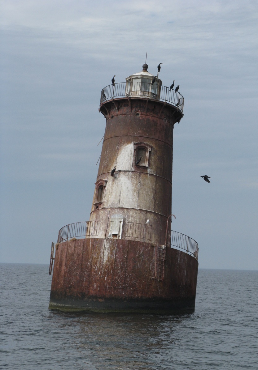
Take for example Sharp’s Island, well up into Chesapeake Bay, and now a historical footnote on Google Earth at 38.621218° -76.363095°:

Here is the Sharps Island Light in 2009, no land is visible at all now:
It has been assumed that it is a victim of “global warming induced sea level rise” also. For example from the book: Slow Motion: The Log of a Chesapeake Bay Skipjack By M. Kei:
Sharp’s Island Light was nudged into a lean by a heavy blow in 1970 and has remained that way ever since.
…
It is one of several vanishing islands in the Chesapeake, a natural process that has been going on for millennia, but which is getting worse with global warming.
But, have a look at this before and after map of Sharp’s Island, from a NOAA/University of Maryland Newsletter in 1990:

And, note the dates of the map comparison, 1848-1942. This is well before our “hottest decade ever”.
This undated historical photograph, shows there wasn’t much left when it was taken, perhaps at high tide:

While “climate change” gets some blame in the article:
Over this last century, once inhabited Chesapeake Bay shorelines have been disappearing rapidly, transformed by rising waters into shoals and marshes. The loss of land, says Michael Kearney, a geographer at the University of Maryland College Park, has been accelerating much faster than sea level rise from global warming can account for.
He and Court Stevenson of the University’s Horn Point Environmental Laboratories believe that accelerated sea level rise is the result of massive upland and shore erosion and depletion of underground waters.
Though it has been generally accepted that water levels have risen steadily since the 1800s, Kearney and Stevenson believe the rates have increased more rapidly along the Eastern Shore since the mid-19th century. From core dating and tide gauge records which date back to the early 1800s in Baltimore, there is evidence of acceleration in rising waters,” Stevenson says. “The problem is that we could not trust existing data.”
He found a way to get more accurate data, and this is what he found, bold emphasis mine:
He found that the rate of change in land area loss during the 1600s and 1700s was fairly low, possibly because sea level rise is slow. “That overlaps the marsh record,” Kearney says, and “it is what we would expect given the several hundred year cooling between 1450 and 1850, known as the Little Ice Age.”
Between 1850 and 1900, however, he found a dramatic increase in land area lost to marsh or erosion: Sharps island near the Choptank River, for instance, lost more than 80% of its remaining area, Poplar Island 38%, James Island 50%.
Then, between 1900 and 1950, another decline in land area occurred. “it must have been eroding very quickly and unexpectedly,” Kearney says. “People were building on a lot of these islands – then all of a sudden they had to move off.”

[Oh no, “Climate refugees” ! Maybe the U.N. IPCC can scare up some reparations money to families /sarc]
“When I saw that island data,” says Stevenson, “that’s when I really got excited: we knew we were seeing accelerated sea level rise in the tide gauge record, but this shoreline data just reinforced that belief.”
Worldwide estimates of sea level rise due to climatic warming range between 1.2 and 2.4 millimeters per year. “The increases in sea level rise we are seeing in the Bay are some 3.4 millimeters a year,” Stevenson says. “There have to be other things going on – global warming alone cannot account for it.” Both he and Kearney believe those other things are land erosion and subsidence, or sinking, due to underground water withdrawal.
The sediment load Chesapeake Bay receives, the result of land clearance and development, is massive – some 2 million metric tons a year. Under this weight, Kearney and Stevenson argue, the Bay crust is sinking, literally “downwarping” the bottom and displacing upper mantle material. At the same time, they hypothesize, groundwater withdrawal from surficial aquifers has been increasing for more than a hundred years.
Of course these are hypotheses, Kearney says. “We haven’t shown that groundwater withdrawal is the problem, but it is curious,” he adds, “that the timing of initial canning operations on the Eastern Shore in the 19th century corresponds to the rapid acceleration in shore erosion of Bay islands as well as increased rates of local marsh loss.”
Just what are the relative contributions of climatic warming, sediment loading and groundwater withdrawal to accelerating sea level rise? That is an unknown, Stevenson says, though he thinks warming is only a quarter of the problem. “But there’s not a lot of data.” The poultry industry, for instance, uses a great deal of groundwater; so do the power plants. With the prospects of increasing development throughout the Eastern Shore, the demand on underground water will continue to increase.
In 1998, the USGS had this to say about the area:
Tide gauges for the Chesapeake Bay and the Mid-Atlantic coast show rates of sea-level rise twice that of the worldwide average.
And here’ s one tide gauge that shows what was going on between 1937 and 1997:

So, it sure seems like land use change, sediment load, groundwater withdrawal, and subsidence, are all factors in the area. Sea level rise is surely a contributor, but only one of many factors. Kudos to whoever the NYT editor was that added the part about subsidence in Norfolk.
“Meteorites and asteroids are constantly entering the atmosphere”
No, when a meteoroid enters the atmosphere, it becomes a meteor. Only if/when it strikes the earth’s surface does it become a meteorite.
Yes, I’m a picky bastard, but scientific language that distinguishes between these three phases of a meteor*’s life cycle deserves to be used correctly. If we abandon the rigor of sticking to our definitions, we’ll come to some shoddy conclusions as a result.
Dan in California says:
Chris: I understand you’re proud of the Chesapeake Bay, but Philadelphia is on the Delaware Bay.
==============================
I stand corrected. Wow.
I pride myself in maps and geography….but you are right.
Tail between my legs…head low…not sure how I made that error. Thanks for pointing it out though.
Chris
Norfolk, VA, USA
Half Empty says: “It’s almost like the entire bay is a collapsed river valley.”
Well, that’s because that is exactly what it is. Any geomorphologist can tell you that in geologic time, the entire east coast of the U.S. is sinking. An examination of the coastline of the east coast shows a series of drowned river valleys and drainage systems. Chesapeake Bay is the most obvious example of this. A coast that is generally rising will have a more linear edge. A good example of this is the west coast of the U.S. In many areas of the west coast, one can find wave-cut terraces (what were once near-shore sea-bottom) several hundreds of feet above present day sea level.
H. Bob;
Great news! How soon can we expect NYC and Bastun to submerge, then?
😀