From a press release provided by Centre national de la recherche scientifique in Paris, France:
Improved estimate of glacier decline in Alaska.
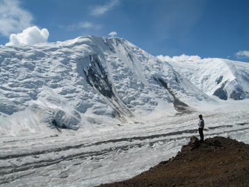
Glaciologists at the Laboratory for Space Studies in Geophysics and Oceanography (LEGOS – CNRS/CNES/IRD/Université Toulouse 3) and their US and Canadian colleagues (1) have shown that previous studies have largely overestimated mass loss from Alaskan glaciers over the past 40 years. Recent data from the SPOT 5 and ASTER satellites have enabled researchers to extensively map mass loss in these glaciers, which contributed 0.12 mm/year to sea-level rise between 1962 and 2006, rather than 0.17 mm/year as previously estimated.
Mountain glaciers cover between 500 000 and 600 000 km2 of the Earth’s surface (around the size of France), which is little compared to the area of the Greenland (1.6 million km2) and Antarctic (12.3 million km2) ice sheets. Despite their small size, mountain glaciers have played a major role in recent sea-level rise due to their rapid melting in response to global climate warming.
Of all the ice-covered regions of the planet, ice loss has been the greatest in Alaska and northwestern Canada, where glaciers cover 90 000 km2. Results from the LEGOS glaciologists and their US and Canadian colleagues, published in the February issue of Nature Geoscience, lead them to conclude that these glaciers have contributed 0.12 mm/year to sea-level rise over the period 1962-2006, rather than 0.17 mm/year as previously estimated by a team at the Geophysical Institute at the University of Alaska (Fairbanks). The new estimate was obtained by comparing recent topographies, derived from Spot 5-HRS (SPIRIT project (2) funded by CNES) and ASTER (GLIMS/NASA project), with maps from the 1950-60s, which enabled loss from three quarters of the Alaskan glaciers to be measured.
How did the team from the Geophysical Institute of the University of Alaska estimate that the contribution of these glaciers to sea-level rise was 0.17 mm/year? In 1995, and then again in 2001, the researchers used an airborne laser to measure the surface elevation of 67 glaciers along longitudinal profiles. These elevations were then compared with those mapped in the 1950s and 1960s. From this, the researchers inferred elevation changes and then extrapolated this to other glaciers. Their results, published in Science (3), pointed to a major contribution to sea-level rise for the 1950-1995 period (0.14 mm/year sea-level rise), which then doubled in the recent period (after 1995).
Why did they overestimate ice loss from these glaciers by 50%? The impact of rock debris that covers certain glacier tongues (4) and protects them from solar radiation (and thus from melting) was not taken into account in the previous work. Moreover, their sampling was limited to longitudinal profiles along the center of a few glaciers, which geometrically led to overestimation of ice loss.
This new study confirms that the thinning of Alaskan glaciers is very uneven, and shows that it is difficult to sample such complex spatial variability on the basis of a few field measurements or altimetry profiles. Thanks to their regional coverage, satellite data make it possible to improve observations of glacial response to climate change and to specify the contribution of glaciers to sea-level rise.
Ice loss from Alaskan glaciers since1962 is evidently smaller than previously thought. However, thinning (sometimes over 10 m/year, as in the Columbia glacier) and glacial retreat remain considerable. Moreover, the spectacular acceleration in mass loss since the mid 1990s, corresponding to a contribution of 0.25 to 0.30 mm/year to sea-level rise, is not in question and proves to be a worrying indication of future sea-level rise.
NOTES:
(1) from Northern Arizona University (US) and two universities in Canada (University of British Columbia and University of Northern British Columbia).
(2) During the 4th International Polar Year (2007-2009), the glaciologists had free access to SPOT 5-HRS data thanks to the SPIRIT project (SPOT 5 stereoscopic survey of Polar Ice: Reference Images and Topographies). The high-resolution images from this satellite can be used to reconstruct precisely the topography of polar ice and thus study its past and future evolution in response to climate fluctuations. LEGOS is the scientific coordinator for this project, which was carried out with CNES, Spot Image and IGN Espace.
(3) Arendt et al, Rapid wastage of Alaska glaciers and their contribution to rising sea level. Science 297, 382-386 (2002)
(4) The lower parts of a valley glacier.
References:
Berthier E., Schiefer E., Clarke G.K.C., Menounos B. & Remy, F. Contribution of Alaskan glaciers to sea level rise derived from satellite imagery. Nature Geoscience, 3(2), 92-95, doi: 10.1038/ngeo737, 2010
“Moreover, the spectacular acceleration in mass loss since the mid 1990s, corresponding to a contribution of 0.25 to 0.30 mm/year to sea-level rise, is not in question and proves to be a worrying indication of future sea-level rise.”
The antarctic loss is ‘accelerating’ according to NASA as well. Of course we are never told the rate of ‘acceleration’. Somehow I think if the acceleration were truly ‘spectacular’ one would openly quantify it.
“Ice loss from Alaskan glaciers since1962 is evidently smaller than previously thought. However, thinning (sometimes over 10 m/year, as in the Columbia glacier) and glacial retreat remain considerable. Moreover, the spectacular acceleration in mass loss since the mid 1990s, corresponding to a contribution of 0.25 to 0.30 mm/year to sea-level rise, is not in question and proves to be a worrying indication of future sea-level rise.”
______________________________________________________________________________
0.25mm/yr sea level rise x 100 years = 25mm/century rise or = 1″ rise per century, am I right?
At the present rate of mass loss, in 100 years the sea level could increase by an entire inch? Why didn’t I just soil myself in fear? Am I missing something here?
e-mail 1213201481.txt between Mann and Jones mentions a paper that suggests temperature signals are not easy to detect in the Arctic, indeed the “last place to look”!
“1981: This looked at statistics of annual/winter/summer
Temperatures for the NH and zones of the NH to see what
signals might you be able to detect. SNR problem really.
Showed that best place to detect was NH annual and
also Tropics in summer. Last place to look was the Arctic
because variability was so high.”
kuhnkat (12:13:16) :
Wow, both barrels!
“UAH switched to a different satellite sometime last year.”
I believe they switched due to a precipitous drop in signal.
“Sensor Drift” was the reason given.
“…mistakes are made in the calibration.”
You bet they are, and they can affect results greatly.
It may be necessary to have a close look at the down linked data,
which includes the sensor collections and ,more importantly, the
ancillary/auxiliary data which shows the configuration of the sensor
at the time of the collection. It might be prudent also, to look at all
uplinked configuration commands and calibration results.
Alaskan glaciers have been retreating for at least 200 years.
We’re doomed and I’m going out to buy a bathing ring before they’re sold out.
In another thirty years I’ll probably be six inches closer to the sea.
‘Ice loss from Alaskan glaciers since1962 is evidently smaller than previously thought. ‘
Well I’ll be. Imagine that.
Upon further examination, as Climate Changes, one region’s glaciers expand and another’s melt off. It hasta be Shasta.
juraj v – Do you also have snow fall and or temperature records. Based only on memory from 40 years of hiking/skiing in the Swiss Alps would lead me to believe that, based on the curve you present, glacier advance is delayed by at least a decade after cloud cover/snowfall increase. Perhaps a lot of snow has to accumulate on top of the glacier before the weight changes the plastic flow of the glacier.
How about the mass loss here, can`t be CO2 can it.
it.
http://i446.photobucket.com/albums/qq187/bobclive/swissglacier.jpg
http://i446.photobucket.com/albums/qq187/bobclive/glacier3.jpg
http://i446.photobucket.com/albums/qq187/bobclive/glacierretreatSINCE1850.jpg
http://i446.photobucket.com/albums/qq187/bobclive/Illecillewaetglacier.jpg
“This new study confirms that the thinning of Alaskan glaciers is very uneven, and shows that it is difficult to sample such complex spatial variability on the basis of a few field measurements or altimetry profiles.”
————-
and leads to these terms in your final assessment : climate change, sea level rise, “spectacular acceleration”, worrying indication of future sea-level rise.
god help you. and the colts 😉
I hardly dare comment. I’m tempted to be rude. How does anyone know if the melt actually made the sea rise? Surely there are other factors such as evaporation, changes in inputs, thermal expansion, undersea floor changes, maybe even silt run off & so on. Is this all understood & sorted? I’ve not checked but if were a betting man…. happy to be corrected, I may be getting too cynical.
“Rob (14:22:36) :
How about the mass loss here, can`t be CO2 can it.
it.”
You seem to be thinking that CO2 increase causes a rise in temperatures. That’s OK, there are a lot of people like you. But how do the photos prove a causal link that you assume?
Rob (14:22:36) :
How about the mass loss here, can`t be CO2 can it.
it.
http://i446.photobucket.com/albums/qq187/bobclive/swissglacier.jpg
Considering the panic that ensued the last time those glaciers advanced and devoured town after town along the glacial routes, they appear to have learned thier lesson this time around. They didn’t attempt to “urbanize” the vacated land. Well, as of 1966 they didn’t.
Nice forest that sprang up. I’m a sucker for evergreens.
Anthony, have you seen this report out of Vancouver :
http://www.vancouversun.com/technology/Arctic+vanishing+faster+than+most+pessimistic+models+researcher/2532293/story.html?utm_source=feedburner&utm_medium=feed&utm_campaign=Feed:+canwest/F229+(Vancouver+Sun+-+News)
I haven’t seen an update on the extent of the Arctic ice coverage in a while. I wonder how this claim matches the actual facts.
I recently drove the Icefield Parkway from Jasper to Banff, one of the most spectacular drives on earth. You can do it in a little over two hours, but I seriously recommend four.
You pass through the Columbia ice field and glaciers are visible at various points. One of the “toes” of the Athabasca glacier comes right down to the highway. We stopped and I hiked to the face in a few minutes. It had been over twenty years since I last stopped, and the amount the glacier had receded versus my memory was significant. So I decided to ask the old chap what was up.
Me; hey, good to see you again, been a while. Listen chum, its just you and me, no one else around, anything you say is just between you and me. So give it to me straight. Are you receding or not? What’s up with this CO2 thing?
Glacier;
I waited a long time, and I thought I was being pretty respectful, but he never answered the question. I got back in my truck and an hour down the road realised my mistake. Frigid and won’t communicate. Its not a guy its a chick. I have to come back with flowers, chocolates and maybe something sparkly if I want an answer.
Seriously the local literature shows that Athabasca has been receding for the last 110 years, prior to which there were no records. Prior also to significant rises in CO2. I’ll do the calculation when I have time to see how long the IPCC 3.7 watts/m2 would take to melt 10 meters of ice… I am betting it is a LOT longer than 110 years.
kuhnkat (12:13:16) : “With all due respect to the hard work of Dr. Spencer and the rest of the UAH crew, remote sensing is highly statistics based and, occasionally, mistakes are made in the calibration.”
If we’ve learned anything in the last few years, we’ve learned to take all scientific data with a grain of salt. That said, I think the satellite temp data are probably the best available at the moment…interpret that how you will.
Personally I hope this short warming trend continues, as it has brought some drought relief to my miserably-governed state (you guessed it: California), but alas I suspect it’s just “natural variation”.
Rob (14:22:36) :
Your picture of the Argentiere glacier in 1850 shows a large lateral moraine behind the church spire indicating that the glacier had already retreated considerably even before 1850.
I take it that the fractional millimeters being reported are arithmetic constructions, having nothing to do with real sea level measurement changes.
I accept the logic of the study and the difficulty of doing it. What bothers me is the unstated bias that seems to underlie the reporting of the work; namely, we found melting which must be from a warmer climate which must be from more CO2 in the atmosphere which must be from people driving SUVs. Can’t they just report what they did and what they found and leave the rest up to Al Gore and Rajenda Pachauri – both very good at making up stories.
K Kilty – couldn’t agree more. There is a plain assumption that the entire water mass ends up in the ocean 1:1. Hmm, funny, several of these glaciers have significant delta systems – so no consideration that aquifers may have changed with changing ice masses – not precipitation patterns around the glacial landscape which also could result in water masses being recycled via the landmass at different rates.
In my opinion – another “computer”-generated hypothetical output with just little hard science behind. Too bad – since these guys are actually quite good scientists.
redetin (12:58:51)
The Arctic Climate Impact Assessment (ACIA) includes this proviso:
2.6.2.1 There is still need for further study before it can be firmly concluded that the increase in arctic temperatures over the past century and/or past few decades is due to anthropogenic forcing.
To most should read:
2.6.2.1 There is still need for further study before it can be firmly concluded that the increase in arctic temperatures over the past century and/or past few decades is due to solar forcing as proposed by work of the Smithsonian Observatory and Lean et al (1995) being the largest possible natural factor not yet fully investigated thoroughly.
Rob (14:22:36) :
No. It can’t possibly be man-made CO2, look at the dates. Just as much of the receeding was prior to higher CO2 levels than after. I’ll reword the question, could it possibly be the sun or other natural causes? Anyone out there able to think and question? (Speaking to the confused masses visiting WUWT in a search for the truth)
http://wattsupwiththat.com/2010/02/07/new-study-using-satellite-data-alaskan-glacier-melt-overestimated/#comment-311757
Speaking of glaciers melting, I see the Pachauri smutty novel just made it into the Australian media:
http://www.theaustralian.com.au/news/world/un-climate-chief-rajendra-pachauri-comes-under-attack-for-steamy-book-promoted-by-bp/story-e6frg6so-1225827732916
I would have posted on the Pachauri thread but it was locked for being O/T.
In other snow & ice related news I see the Tasmanian CRC for Antarctic Climate and Ecosystems is claiming the “drought” in Western Australia may be tied to increased snowfall in Antarctica. They go a step further to speculate that this has all been linked to man-made GHGs:
http://au.news.yahoo.com/thewest/a/-/newshome/6773111/wa-drought-is-proof-of-climate-change/
Just as a minor point of fact… while the SW of Western Australia is experiencing gradually decreasing rainfall (this is well established) the northern portion of the State (think around the Ord River) has been getting plenty of rain. But given that 3/4 of the population lives in and around Perth (in the SW) it is only the low rainfall that occurs down here that counts I guess… another blatant example of anthropocentric thinking.
Recently, there was a post on WUWT showing NASA was estimating that Antarctica was melting at the rate of around 100 cubic kms per year – this represents about 0.28mms annual rise in ocean levels.
Here we have an estimate of 0.12mms per year from melting glaciers in Alaska.
If the world’s other melting glaciers give us – let’s guesstimate a generous number of 0.25mms per year – that makes a total of 0.65mms per year of annual sea level rise being provided by melting glaciers.
However, the University of Chicago (recent WUWT post) says the average sea level rise has recently been rising at around 3.2mms per year.
In other words, what accounted for the other 2.55mm (or 80%) annual rise in sea levels? Obviously, there have to be other factors, presumably geological, at work. It is not sediment loads dumped into the oceans from rivers, which amount to around an annual 20 billion tonnes (or 10 billion cubic metres), equivalent to 0.03mms annual rise.
The only possible reason I can think of is that the continents are sinking very slowly into the mantle under their own weight.
The point, once again, is that anything to do with climate is always very much more complex than the alarmists would like us to believe.
Well someone has the right idea, Read here from Englands daily express.
GLOBAL warming is set to become global cooling this century, a leading analyst claimed yesterday.
Professor Michael Beenstock said theories of climate change are wrong.
He warned climatologists have misused statistics, leading them to the mistaken conclusion global warming is evidence of the greenhouse effect.
http://www.express.co.uk/posts/view/156811/Global-warming-to-become-global-cooling-claims-expert
hmmm 0.12mm PER YEAR rather than 0.17mm ha?
Well just to check for myself, I went down to the beach this morning and stuck a ruler into the water to check the sea level. I got these empirical results…
Up 8 inches…..down 6 inches…..up 2 feet (wow) down 2.2 feet….up 13 inches…down 1foot
All that within 45 seconds. Anyone good with maths to help extrapolate these to 100yrs? (Dang sand in my shoes)
Oh! where do I apply for a grant?