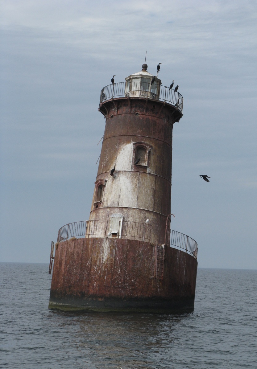
This is a map and photo of Sharp’s Island and its sinking lighthouse in Chesapeake Bay, we’ll get back to that after the main article about Norfolk.

GreenHell Blog writes: In an above-the-fold, front-page story, the Times’ Leslie Kaufman tried to tell a sad tale about global warming-induced sea-level rise wreaking havoc in Norfolk, VA.
If the moon is going to be full the night before Hazel Peck needs her car, for example, she parks it on a parallel block, away from the river. The next morning, she walks through a neighbor’s backyard to avoid the two-to-three-foot-deep puddle that routinely accumulates on her street after high tides.
For Ms. Peck and her neighbors, it is the only way to live with the encroaching sea.
As sea levels rise, tidal flooding is increasingly disrupting life here and all along the East Coast, a development many climate scientists link to global warming.
And of course, what tale of global warming would be complete without an “expert”?
Many Norfolk residents hope their problems will serve as a warning.
“We are the front lines of climate change,” said Jim Schultz, a science and technology writer who lives on Richmond Crescent near Ms. Peck. “No one who has a house here is a skeptic.”
As sea levels rise, tidal flooding is increasingly disrupting life here and all along the East Coast, a development many climate scientists link to global warming.
The article continues, bold emphasis mine
But Norfolk is worse off. Situated just west of the mouth of Chesapeake Bay, it is bordered on three sides by water, including several rivers, like the Lafayette, that are actually long tidal streams that feed into the bay and eventually the ocean.
Like many other cities, Norfolk was built on filled-in marsh. Now that fill is settling and compacting. In addition, the city is in an area where significant natural sinking of land is occurring. The result is that Norfolk has experienced the highest relative increase in sea level on the East Coast — 14.5 inches since 1930, according to readings by the Sewells Point naval station here.
But, that is just part of the story. While Norfolk has fill subsidence issues, other areas of Chesapeake Bay have disappearing islands.
Take for example Sharp’s Island, well up into Chesapeake Bay, and now a historical footnote on Google Earth at 38.621218° -76.363095°:

Here is the Sharps Island Light in 2009, no land is visible at all now:
It has been assumed that it is a victim of “global warming induced sea level rise” also. For example from the book: Slow Motion: The Log of a Chesapeake Bay Skipjack By M. Kei:
Sharp’s Island Light was nudged into a lean by a heavy blow in 1970 and has remained that way ever since.
…
It is one of several vanishing islands in the Chesapeake, a natural process that has been going on for millennia, but which is getting worse with global warming.
But, have a look at this before and after map of Sharp’s Island, from a NOAA/University of Maryland Newsletter in 1990:

And, note the dates of the map comparison, 1848-1942. This is well before our “hottest decade ever”.
This undated historical photograph, shows there wasn’t much left when it was taken, perhaps at high tide:

While “climate change” gets some blame in the article:
Over this last century, once inhabited Chesapeake Bay shorelines have been disappearing rapidly, transformed by rising waters into shoals and marshes. The loss of land, says Michael Kearney, a geographer at the University of Maryland College Park, has been accelerating much faster than sea level rise from global warming can account for.
He and Court Stevenson of the University’s Horn Point Environmental Laboratories believe that accelerated sea level rise is the result of massive upland and shore erosion and depletion of underground waters.
Though it has been generally accepted that water levels have risen steadily since the 1800s, Kearney and Stevenson believe the rates have increased more rapidly along the Eastern Shore since the mid-19th century. From core dating and tide gauge records which date back to the early 1800s in Baltimore, there is evidence of acceleration in rising waters,” Stevenson says. “The problem is that we could not trust existing data.”
He found a way to get more accurate data, and this is what he found, bold emphasis mine:
He found that the rate of change in land area loss during the 1600s and 1700s was fairly low, possibly because sea level rise is slow. “That overlaps the marsh record,” Kearney says, and “it is what we would expect given the several hundred year cooling between 1450 and 1850, known as the Little Ice Age.”
Between 1850 and 1900, however, he found a dramatic increase in land area lost to marsh or erosion: Sharps island near the Choptank River, for instance, lost more than 80% of its remaining area, Poplar Island 38%, James Island 50%.
Then, between 1900 and 1950, another decline in land area occurred. “it must have been eroding very quickly and unexpectedly,” Kearney says. “People were building on a lot of these islands – then all of a sudden they had to move off.”

[Oh no, “Climate refugees” ! Maybe the U.N. IPCC can scare up some reparations money to families /sarc]
“When I saw that island data,” says Stevenson, “that’s when I really got excited: we knew we were seeing accelerated sea level rise in the tide gauge record, but this shoreline data just reinforced that belief.”
Worldwide estimates of sea level rise due to climatic warming range between 1.2 and 2.4 millimeters per year. “The increases in sea level rise we are seeing in the Bay are some 3.4 millimeters a year,” Stevenson says. “There have to be other things going on – global warming alone cannot account for it.” Both he and Kearney believe those other things are land erosion and subsidence, or sinking, due to underground water withdrawal.
The sediment load Chesapeake Bay receives, the result of land clearance and development, is massive – some 2 million metric tons a year. Under this weight, Kearney and Stevenson argue, the Bay crust is sinking, literally “downwarping” the bottom and displacing upper mantle material. At the same time, they hypothesize, groundwater withdrawal from surficial aquifers has been increasing for more than a hundred years.
Of course these are hypotheses, Kearney says. “We haven’t shown that groundwater withdrawal is the problem, but it is curious,” he adds, “that the timing of initial canning operations on the Eastern Shore in the 19th century corresponds to the rapid acceleration in shore erosion of Bay islands as well as increased rates of local marsh loss.”
Just what are the relative contributions of climatic warming, sediment loading and groundwater withdrawal to accelerating sea level rise? That is an unknown, Stevenson says, though he thinks warming is only a quarter of the problem. “But there’s not a lot of data.” The poultry industry, for instance, uses a great deal of groundwater; so do the power plants. With the prospects of increasing development throughout the Eastern Shore, the demand on underground water will continue to increase.
In 1998, the USGS had this to say about the area:
Tide gauges for the Chesapeake Bay and the Mid-Atlantic coast show rates of sea-level rise twice that of the worldwide average.
And here’ s one tide gauge that shows what was going on between 1937 and 1997:

So, it sure seems like land use change, sediment load, groundwater withdrawal, and subsidence, are all factors in the area. Sea level rise is surely a contributor, but only one of many factors. Kudos to whoever the NYT editor was that added the part about subsidence in Norfolk.
How can they call sinking land, sea level rise?
@ur momisugly latitude says:
November 26, 2010 at 1:35 pm
How can they call sinking land, sea level rise? They don’t want to get tangled up discussions of relativity. It would get them off message.
Sounds more like land levels sinking than sea levels rising.
Here’s the latest tide gauge data for Solomons Island MD.
http://tidesandcurrents.noaa.gov/sltrends/sltrends_station.shtml?stnid=8577330
It is useful to click around that tide page. Very little evidence whatsover for accelerating sea level rise.
Looks like the region may be a smidgen higher than the worldwide sea level rise average of 3.0 mm/year, but all pretty much within that range with the errors taken into account.
My old Rand McNalley globe shows the world’s oceans to be connected. Do new globes show where the oceans have been partitioned off into sections so some can rise while others stay the same? Has the moon’s gravitational pull changed so that it now selectively affects tides?
Maybe it’s a combination of both.
This article from the Daily Telegraph , dated 7th October 2009 might be pertinent to any further discussion on this topic.
http://www.telegraph.co.uk/earth/earthnews/6226537/England-is-sinking-while-Scotland-rises-above-sea-levels-according-to-new-study.html
My little unimproved lot, almost at the end of Broad Marsh Lane, Hayes VA, will have a dock: my great-grand-xgrand children can drive pilings for a dock and pay taxes with moorage fees. Better that than scavenging wind-fall lumber for heat, when the glaciers advance.
For now, San Jose, Costa Rica, about 3000 feet elevation, offers other concerns: earthquakes, volcanoes, land slides, bridge collapses, and dengue fever.
Think I´ll stay awhile. UNFCCC Executive Secretary Figueres has plans for her hometown and its needed infrastructure: of the oldest democracy on the Isthmus gets at the head of the welfare line, the UN can channel expropriations from industrialized to developing nations. Approval of Nationally Appropriate Mitigation Actions {NAMA}, will provide mass transportation and waste treatment facilities, for example. Keep an eye on Cancun for the latest.
Thanks, all, especially our host, for continued good work.
What I find sad about the global warming movement is the mindset that if the facts don’t add up, omit or change the facts until they tell the desired story. The continued and increasingly frenzied skewing of reality by the “believers” underscores how desperate they have become to shield themselves from the growing refutation of their doomsday prophesies.
Has anyone accurately measured the ocean bottom to see if maybe it is rising every year? Does the sediment dumped into the oceans by rivers and erosion of shorelines contribute significantly to sea level rise? Is it possible that the continents are settling down instead of more water rising up?
I wonder if Sharpe Island was Michener’s inspiration for “Devon” Island in Chesapeake.
Seems they’ve been worried about erosion in Chesapeake Bay for a long time.
It’s almost like the entire bay is a collapsed river valley.
Archaeologists learned in the 19th century that the James River (which flows into the Chesapeake) has been rising a little over a foot per century since 1607 when colonists arrived in Jamestown, so this is news only to alarmist journalists. English colonists began settling the Norfolk area shortly after Jamestown, so a lot of the roads, especially adjacent to the water, were laid out over 400 years ago. I don’t think we should be surprised that things have changed a bit in four centuries.
I believe that I could qualify as a ‘science and technology writer’ who actually understands the difference between relative and absolute sea level.
And I would submit that Jim Schultz and his neighbors on the Richmond Crescent are experiencing changes in land use and normal coastal processes.
So essentially the dumba frakking hippies want to be one of them global warming super local phenomenon right? Because the ocean where I live has become so much less these last few years so maybe it went to drown out a puny island somewhere else for some local people in their local light house made for local people only . . .
@ur momisugly Kim Moore says:
November 26, 2010 at 1:59 pm
Actually, the Earths gravitation does vary by location ( ooh! an unintentional rhyme 🙂 ) Here’s a recent gravitational map ( see sidebar ) http://www.space.com/scienceastronomy/gravity_map_030725.html
Gee, somehow most if not all of the real reasons for this case of disappearance due to “global warming-induced sea level rise,” sound amazingly like the real reasons given for how New Orleans will eventually go away due to “global warming-induced sea level rise.”
WUWT? ☺
I lived in Romancoke on Kent Island, Chesapeake Bay in the 1970s. There were no city water mains at the time and all my neighbors had their own water wells. I haven’t been back to see if that’s still the case.
This reminds me of New Orleans. Much of the city is below sea level and still falling, the only thing keeping Lake Pontchartrain from taking over the city are artificial barriers and water pumps, and thanks to all the levees on the Mississippi River the protection from hurricanes is eroding faster than ever.
Natural forces are always eroding land. Just south of Norfolk are the Outer Banks, barrier islands formed by wind and the Gulf Stream current. I visited a place called Fort Fisher. During the Civil War, Fort Fisher guarded a key port in nearby Wilmington. There remains the sand fort the Confederate army built. When they built it, it was adjacent to the ocean. Today it is several hundred feet away from the ocean.
Nature is always changing the land. Nothing we do will change that. The difference is, now those natural changes can be taken advantage of for nefarious purposes.
Reminds me of Venice, Italy. After a thousand years of the city of Venice sinking, it is now being flooded by rising sea levels.
Floods turn Venice into one big canal. http://www.theaustralian.news.com.au/story/0,25197,24743931-2703,00.html
Could part of the reason possibly be subsidence? Venice anyone? That might also help explain why a big sturdy lighthouse was pushed out of vertical by the wind.
Recently I was lucky to visit a beach where I spent many a happy childhood summer’s holidays forty years or more ago. The beach and sea are still were I left them, as was the ancient harbour, pier etc. If we are experiencing seal level rise then I’d love to see where. More likely we are seeing changes due to coastal development, often caused by industrialisation and population growth. Of course we also have some ongoing land elevation changes due to rebound etc due to the last ice age. But hey, why not blame everything on AGW? It’s easier than doing real science.
I am going to suggest this is not fraud so much as pure stupidity.
I was born & raised in Portsmouth, Virginia just across the Elizabeth River from Norfolk. Norfolk also borders the Elizabeth River. At high tides and heavy rains both Norfolk and Portsmouth have areas that have always flooded. In fact, I could sit on my front porch and see tide water coming out of the storm drains, instead of water flowing away into the drains. This was in the late 1930s & ’40s. Waterfront areas did, and still do, flood in heavy rains and high tides. I don’t think AGW /”Climate Change” or “Climate Disruption” has anything to do with it. This is just another scare tactic on the part of the alarmists.
I live in the Chesapeake watershed (which now extends all the way into western upstate New York, very nearly to the Great Lakes, thanks to drainage ditches being classified as “intermittent streams” in many comprehensive plans), and the entire eastern shore is alluvial land.
The drainage from the Susquehanna when the glaciers melted deposited it, and now it is subsiding.
Funny how so much on earth is cyclical, over millions and millions and millions and millions of years…
One key feature of sea level rise due to ‘global warming’ is that is should be uniform around the world. Global warming is *not* going to cause oceans to pile up more in one place than another. Local variation MUST be due to other causes, and the variability of ‘sea level rise’ magnitudes and rates on a local scale indicate that any ‘global’ effect is so small as to be lost in the data noise.