Guest post by David Middleton
04 APRIL 2018
Mississippi River flooding worse now than any time in past 500 years
Efforts to control the river’s flow with levees and other structures have increased the risk of dangerous floods.
Floods on the mighty Mississippi River are larger and more frequent today than at any time in the past 500 years — in part, a new study suggests, because structures erected to control the river have increased the flood risk.
[…]
The US Army Corps of Engineers, the government agency that manages the river flow, declined to comment on the study. But Robert Twilley, a coastal-systems ecologist who directs the Louisiana Sea Grant College Program at Louisiana State University in Baton Rouge, says that the study “should be on every desk of every Corps engineer who is designing infrastructure for the Mississippi River”.
To reconstruct the river’s history, Samuel Munoz, a geoscientist at the Woods Hole Oceanographic Institution in Massachusetts, and his colleagues looked at oxbow lakes and oak trees on the lower Mississippi between southern Missouri and Louisiana. Oxbow lakes are coils of river that became detached from the main flow as the Mississippi changed course.
[…]
The result surprised Munoz. Both the frequency and magnitude of floods on the Mississippi have increased in the past 150 years. Floods were correlated with global weather patterns linked to the El Niño–Southern Oscillation in the Pacific Ocean and the Atlantic Multidecadal Oscillation, both of which influenced when and how much rain entered the system. But these climate cycles couldn’t explain all of the increase.
Human influence
Munoz and his team suggest that up to three-quarters of the increased flood risk might be attributable to the dams, walls and levees that now confine the river.
[…]
Humans build things in floodplains and try to control nature… And we wonder what could possibly go wrong… Kind of like building expensive resorts and beach houses in places frequented by hurricanes. However, it seems like something is missing from this article… What’s missing? No mention of fossil fuels, heat-trapping greenhouse gases or anthropogenic climate change!
The worst flooding in 500 years isn’t being attributed to Gorebal Warming! Shocking? Not really. Mississippi megafloods aren’t unprecedented.
Cahokia’s emergence and decline coincided with shifts of flood frequency on the Mississippi River
Samuel E. Munoz, Kristine E. Gruley, Ashtin Massie, David A. Fike, Sissel Schroeder and John W. Williams
PNAS May 19, 2015. 112 (20) 6319-6324; published ahead of print May 4, 2015. https://doi.org/10.1073/pnas.1501904112
Edited by James A. Brown, Northwestern University, Evanston, IL, and approved April 8, 2015 (received for review January 28, 2015)
Significance
Our paper evaluates the role that flooding played in the emergence and decline of Cahokia—the largest prehistoric settlement in the Americas north of Mexico that emerged in the floodplain of the Mississippi River around A.D. 1050. We use sediment cores to examine the timing of major Mississippi River floods over the last 1,800 y. These data show that Cahokia emerged during a period of reduced megaflood frequency associated with heightened aridity across midcontinental North America, and that its decline and abandonment followed the return of large floods. We conclude that shifts in flood frequency and magnitude facilitated both the formation and the breakdown of Cahokia and may be important factors in the declines of other early agricultural societies.
Abstract
Here we establish the timing of major flood events of the central Mississippi River over the last 1,800 y, using floodwater sediments deposited in two floodplain lakes. Shifts in the frequency of high-magnitude floods are mediated by moisture availability over midcontinental North America and correspond to the emergence and decline of Cahokia—a major late prehistoric settlement in the Mississippi River floodplain. The absence of large floods from A.D. 600 to A.D. 1200 facilitated agricultural intensification, population growth, and settlement expansion across the floodplain that are associated with the emergence of Cahokia as a regional center around A.D. 1050. The return of large floods after A.D. 1200, driven by waning midcontinental aridity, marks the onset of sociopolitical reorganization and depopulation that culminate in the abandonment of Cahokia and the surrounding region by A.D. 1350. Shifts in the frequency and magnitude of flooding may be an underappreciated but critical factor in the formation and dissolution of social complexity in early agricultural societies.
[…]
There were at least 8 Mississippi River megafloods between 200 and 2000 AD. If the flooding is worse today than at any time in the past 500 years, it currently ranks between flooding events II and III.

The megaflood hiatus ran from roughly the nadir of the Migration Period Cooling to the peak of the Medieval Warm Period. The megaflood frequency abruptly increased near the onset of the Little Ice Age:

While our dams, levees and other flood-control structures may have ironically contributed to the worst Mississippi River flooding in 500 years, they had nothing to do with the previous eight megafloods.
Speaking of megafloods that humans didn’t cause… Have you ever heard of the Zanclean megaflood? It was triggered by the Messinian salinity crisis (MSC). It was a doozy. If Gavin Schmidt’s Silurian civilization had been thriving on the Messinian salt flats during the Late Miocene, the Zanclean megaflood would have wiped them out without a trace. The transition from the MSC to the Zanclean megaflood marks the transition from the Miocene to the Pliocene. It left a serious mark on the stratigraphic record.
Some reconstructions of Zanclean megaflood suggest that sea level in the Mediterranean could have risen at a rate of 10 meters per day during the peak flow of water from the Atlantic into the Mediterranean basin.
A Megaflood-Powered Mile-High Waterfall Refilled the Mediterranean
Evidence of the Zanclean megaflood in the eastern Mediterranean Basin
Catastrophic Flood of the Mediterranean After the Messinian Salinity Crisis
What about the 1927 flood, doesn’t show on the graph
Sorry, didn’t notice the comments above re the book “Rising Tide” . An incredible story of the flood of the river and the change it made to African American politics as well as the role of US Army
Balderdash. Whoever claimed that has never read Mark Twain’s “Life on the Mississippi”. Twain recounts stories of the steamboats sailing through flooded fields miles outside the river channel.
We have been though this before as noted, and I don’t know enough about archaeology and sedimentology, especially about the area. I have camped and explored in and adjacent to southern Illinois. The letter accompanying the paper questions the archaeological conclusion —
http://www.pnas.org/content/112/29/E3753
Also it does seem that settlements along the river, moreso downstream, dependent on wood, would leave a lot less left to study. There is also a lot more productivity than out in the rockier west, like way up the Missouri which debouches in their study area.
The 1973 flood (I studied it a little in Louisiana) was exceptional in that it was out of its bank for two months, despite, and due to, water control. 1975 was also very high. I lived for nearly three decades up on a low plateau where the 1927 flood came to its base, constricted later successfully by levees.
Floods could come from several climates between the mountains and some of that might explain their data. Since the Missouri is the longest contributor, maybe Montana would be a better name for the Mississippi.
This is also interesting if you can find it. Cline, I. M. 1928. Floods in the lower Mississippi. New Orleans Board of Trade. 29p. The lower gets them all. Don’t forget the Missoula floods. Lots of rocks to wipe out everything.
The central mass of the Laurentide ice-sheet, when-ever it melted out, it went out the Mississippi river. As in the big melt-back years from 13,000 to 9,200 years ago, but also every single summer for the last 50,000 years of the ice age.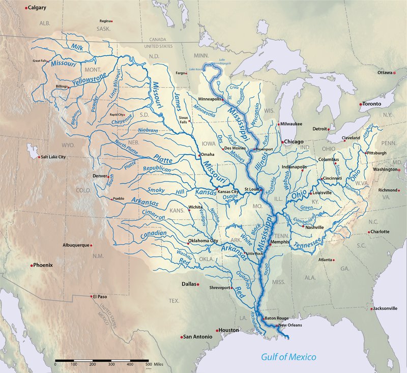
Think of those floods.
And that great watershed washed all the organic material downstream, and deposited it in the gulf.
Millions ? of years later, it turned into oil and natural gas.
Which is why New Orleans is being flooded. With all the damming, channeling and dredging, the products of erosion never reach the delta. But the reservoirs created by dams on the Missouri are slowing filling with sediment. The original proposal for the Missouri was the reservoirs would last 600 years.
There’s a good reason why the Pleistocene section of the Gulf of Mexico can be <20,000' thick in some mini-basins.
OK, now assume one of these heavily fueled deposits moves over the top of a magma hotspot….
That should be >20,000′.
And look at the map again. Anytime it rained heavily anywhere in the central US, it ended up in the Mississippi. Why did the early Chahokia culture build huge mounds in their cities based on the great corn growing culture along the Mississippi? Why did the ancient Sumerians build huge ziggurats in Mesopotamia? Why did the Sumerians cover the outside with oil from seeps?
Duh, it flooded like crazy every few years like it was a once in a 500 year flood. Everybody and their animals scrambled to get to the top and wait it out for several days.
Except for the poor farmer and herder Noah, who had to build a raft for his family and animals to ride out the annual Mesopotamian floods.
Way back in the Pleistocene, when I was in college, my strat & sed plrofessor would run a movie like this at least once a semester…
http://video.wgby.org/video/2365024187/
Good vid David.
And the story/myth of Noah is a perfect example of what I was talking about. A great flood happens. Noah was prepared, having built a rather large reed boat. Family and all the animals are saved and the big boat floats down the Euphrates for 40 days and forty nights before they land on solid ground. The Babylonian Jewish slaves in 600 BC understand the meaning of the story/myth and over time adjust the story and it becomes part of the Bible.
Yet, It was just a common flood. So common that Noah built a stand-by giant reed boat.
My personal hypothesis is that Noah lived in the Black Sea basin during the Holocene Climatic Optimum.
I’m old. Although, my mineralogy/petrology/structural geology professor and adviser, Dr. Piotrowski, was fond of saying, “Remember way back in the Pleistocene? When we covered…?”
Igneous petrology was MWF 1-2 PM, with lab from 2-5 on W… Sitting through 4 hours of phase diagrams is like experiencing geologic time.
Johnny Horton does the Mississippi:
Worst Mississippi floods in 500 years? And all caused my Man?
What’s not for an alarmist to like!
*Sigh*
“And all caused by Man?”
That’s Mann; Michael E. Mann………………………………!
Check the precipitation numbers.
Zero change anywhere in the world really.
The study needed to show this to prove their case but of course didn’t since they are climate scientists.
Well… at least they didn’t invoke Gorebal Warming as the cause.
Just checked Times-Picayune and then called my brother who lives in Pearl River, LA. The degree of panic indicated from each was rather understated. One point to consider, Pittsburgh is bracing for flooding from Allegheny and Monongahela rivers. Western PA has been getting a lot of rain last 30-40 days, not to mention snow melt in the Laurel Highlands, so the Ohio will be rising, which means Big Muddy will be remaining near and above average flood stage for the foreseeable future. ACoE has been opening Bonnet Carre spillway gates since the 8th, 58 of 350 gates currently open and 10 more are scheduled to open in the next few days. ACoE does not seem quite ready to hit the siren buttons but is suggesting people get ready, since, ya know, it is spring along the lower Mississippi.
Looks like they closed the Bonnet Carre gates on the 30th of March or so.
For some reason the water level decreased dramatically about two weeks after they opened some of the “gates” to divert water to “The Lake”.
As Walter asserts, control of Big Muddy is a complex issue/problem/challenge.
Gums…
Open, close, open, close, almost like it is a system of some sort. 😉 They can’t over dump into Ponch, that would kinda defeat their purpose. I remember flooding in Slidell and backing into the Pearl River region from elevated level of lake. The levee system along south shore diverts away from New Orleans, that water still has to go some place. One of my brothers works at Stennis Space Center and does some work at Michoud, flooding issues are always on their mind at both.
Once upon a time in my career we were briefed on the Mississippi River and the successes and mostly the failures of flood control efforts by the Corps. It was part of our briefing on New Orleans, the Mississippi Delta and Lake Pontchartrain. The Corps had charts of all the floods within the system back to before the Civil War. So I don’t see how the first study is anything new. Several times the Corps was relatively clear that levees and other structures had not necessarily made anything better. One Colonel, who was about the retire, said in conclusion at one briefing, the Mississippi River is going to do what the Mississippi River is going to do, we can’t stop it. The briefing generally related to New Orleans hurricane risks. Some of the very first levees built along the river were built to protect New Orleans primarily from tropical storms back in the 18th Century.
https://en.wikipedia.org/wiki/Great_Mississippi_Flood_of_1927
Immortalized in literature.
Chimp, the wikipedia link your provided reminded me that it was in and around the 1927 Flood that the federal government got into disaster relief big time and has been in it ever since. I have often wondered if the feds hadn’t gotten in the game whether people would still be building in flood plains, front dunes of beaches, etc.
Look at this current warm surface wind which is moving up the arid side of the plains. It seems that the typical pattern should have this more to the east, imo. …https://earth.nullschool.net/#current/wind/surface/level/overlay=temp/orthographic=-103.49,53.02,672/loc=-110.216,50.088
The next 2-3 weeks will be instrumental in the flow of all the northern tributaries. If it really warms up quick everywhere at once now in late April early May and rains heavy on the more northern high snowpacks, then could definitely see a huge flood all in a hurry. Some of the biggest floods I have seen have been rain in warm weather on a high snowpack, such as the recent 1-200 Year Alberta/Calgary flooding on June 21st/2013 that did a lot of damage real quick, like overnight.
https://en.wikipedia.org/wiki/2013_Alberta_floods
Or it may stay coolish for the next month without a lot of rain, and have an orderly freshet flow down the numerous tributaries through to the Missouri/Mississippi watersheds. Lets hope for a slow melt now. Had enough misery this winter to last several years.
Old China history has this legend, that all attempt to control the Yellow river (with levees) failed, until a man succeeded. Not with levees, but with diverting waterways, flooding selected areas they don’t cared about. The man was made Emperor, if I remember well, for the feat included successful union of lots of different people.
Cahokia is or was a mounded city, within the MS floodplain. The mound was built by the inhabitians over a several hundred year period. Some contest this idea and say evidence suggest the mound was build very quickly and completed about 1050. The town was deserted by 1400. Like other mounded cities is was build near the river for many reason, food and water being the most likely. Would suggestion reading the book Cahokia by Timothy R. Pauketat before getting too carried away with the issues in this article.
The region around Vicksburg had a lot of inhabitants in the past because it is naturally above the flooding, though shot through with deep ravines and watercourses. Farther south the land pretty well flattens out, so anyone living there had to take steps to survive flooding.