And it keeps getting worse. Earlier we said the “worst case scenario” was likely to happen, now that includes a delayed turn keeping Irma over the warm waters of the Gulf longer.
https://twitter.com/RyanMaue/status/906400279653965824
The warm water in the Gulf is going to keep the beast known as Irma, fueled and fast:
https://twitter.com/RyanMaue/status/906397985206145025
Maue adds:
https://twitter.com/RyanMaue/status/906403238341169152
Am going to stick my neck out here and say l think the models have got the track of this hurricane wrong.
The nullschool weather maps suggest to me that this hurricane is likely to keep moving westwards and move into the middle of the Gulf instead. Because that looks like the path of least resistance to me.
I hope you’re right. Based on the animation above it’s going to have to make a hard right turn to follow the latest cone projection.
Yep. I see the same thing.
This storm could Central America or southern Mexico early in the week.
Also, the water in the eastern Gulf of Mexico is very warm, but because it is also very shallow, the heat content is nothing spectacular:
http://www.aoml.noaa.gov/phod/dataphod1/work/HHP/NEW/2017250go.jpg
This, coupled with increasing wind shear as Irma enters the Gulf of Mexico (if that indeed happens), should keep Irma in check:
http://tropic.ssec.wisc.edu/real-time/atlantic/winds/wg8sht.GIF
Contrast the eastern Gulf of Mexico TCHP with Irma’s previous track:
http://www.aoml.noaa.gov/phod/dataphod1/work/HHP/NEW/2017250at.jpg
Eye of a hurricane can reach Havana.
Doesn’t this thing look like it’s headed for Havana then Mexico? What’s the rationale for a turn at all?
There is an unseasonably strong cold front situated over the southeast that should block further westward progress for Irma.
That is exactly what is supposed to be a big factor in turning it north. Click here: https://www.windy.com/?40.117,-85.772,5
Got to the scale on the right of that map and raise the elevation for the image to show winds at about 9,000 m and one will get a better idea of some of the steering currents that effect the track of the storm. The “trough” or low pressure with powerful winds flowing in an arc down SE over Arkansas then turning E over Mississippi then NE over Alabama is what is supposed to turn Irma to the north into Florida.
Yes wind shear will be a real issue for lrma if it tracks north.
Over the northern half of Florida you have surface winds moving SW but the upper winds are moving eastwards. So you will have the lower path of hurricane Irma moving one way while the upper part moving the other way While the winds over the middle of the Gulf of Mexico are more suitable for the hurricane to be able to take this route instead.
Bill Maher: It’s An ‘Inconvenient Truth’ That Climate Change Deniers’ Homes Are In Irma’s Path
http://m.huffpost.com/us/entry/us_59b387abe4b0dfaafcf81e69?ncid=edlinkushpmg00000313
Bill, your folks moved to florida because they got tired of you living in their basement, rent free….
Irma down to 130 mph at the moment. I mentioned the possibility(of Irma weakening because of interaction of the southern circulation over Cuba with the farther south track) during my interview on Relevant Radio yesterday.
Also mentioned the fact that water temp in the Keys right now is 89 degrees and along the west coast of FL, 88 degrees.
This brings the potential of restrengthening in play, depending on how much of the circulation is over that warm water and for how long.
Also, the farther west path means more areas to the east/right of the hurricane that will have the speed of the hurricane traveling north added to the speed of the wind(vs subtracted from the wind for areas to the left/west).
If Irma is going north at 20 mph for instance that equated to a 40 mph difference on the right(wrong/bad) side vs the left(good side).
If the hurricane is at 110 mph for instance, it means 130 mph on one side and 90 on the other.
Hopefully land will disrupt it enough to keep the intensity down.
When Irma was out to sea with no serious land interaction and no wind shear, there was nothing to complicate the forecast intensity.
Now we have a tremendous disparity in potential strength with land interaction and some wind shear, as well as the exact track along the west coast of FL uncertain but key.
“If the hurricane is at 110 mph for instance, it means 130 mph on one side and 90 on the other.”
Not how it is defined. It is then considered a 130 mph hurricane.
So I have a dumb question. Doesn’t the “lift” of Harvey and Katia drag air into the Gulf like a vacuum cleaner. Could that pull Irma further west? It would be instructive to see a cross section of a hurricane and surrounding atmosphere showing the air flow. Even better that of a chain of hurricanes.
Harvey and Katia are history.
I guess we’ll see how well the NHC track validates in this radar loop: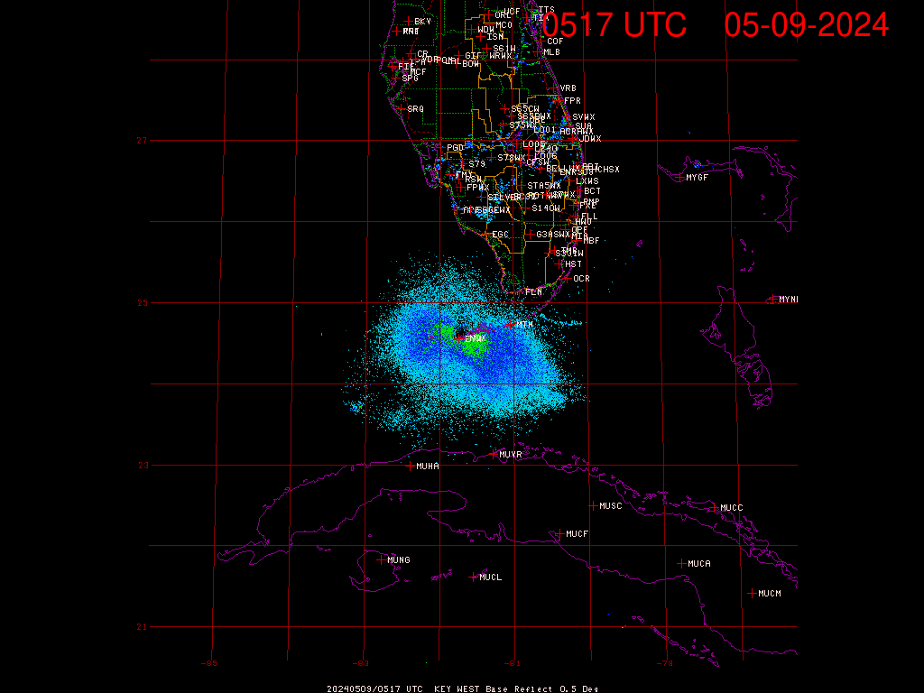
The hurricane eye slowed its movement along the coast of Cuba.
If it stalls now, with half of it over land, it will just fizzle out. It’s already lost a lot of moisture and the cloud tops are cooling. The contiguous central area is only a quarter of what it was before making landfall in Cuba.
I read somewhere it’s just been upgraded to cat 5 again, but that’s just eye-wall max speeds, overall it’s badly weakened.
Levi Cowan just put out an update
https://www.tropicaltidbits.com/
Says that even with Irma still hugging the coast of Cuba that S. Florida is receiving TS force winds up to 60 mph from the outer bands. That is a big factor in assessing the danger from this storm. It is just so huge and so it the hurricane force wind field. If it turns north and goes up the west coast as it is still projected to do, there is no getting away from it’s effects for basically anyone in Florida.
My family has a vacation home in Port Charlotte. The home is almost at the end of a channel that leads into the bay. It has a 15′ sea wall along that channel. But the projected track takes the core of this storm right over it and I’m wondering if we’ll be going down there for vacation for a week during February as we had planned. If things go as the NHC is showing right now that storm will be passing over the Port Charlotte area right around high tide.
Taking the north turn in the last several satellite pics starting at 14:00 Z / UTC / GMT . Goes16 shows the same.
thanks Bill, do you have a link. The stuff I’m following has a few hours lag.
https://weather.msfc.nasa.gov/GOES/
Use the Goes16 ones since they are the highest resolution now. It is getting a lot of traffic of course so you might have to try on and off. Usually only a few minutes behind. Bookmark this page for every day use.
There are also some experimental players for Goes16 which are really good. I don’t if they are going to stick around (whereas the nasa.gov./Goes/ site has been available for almost 15 years now). One has to play around to figure out how to use these sites but they can provide pics and animations for every minute.
http://weather.cod.edu/satrad/exper/
http://rammb.cira.colostate.edu/ramsdis/online/goes-16.asp
thanks for the reply Bill. I found the colostate one but the others will be useful too.
If that is accurate the storm may already have started it’s northern turn.
I don’t know – it just looks like it’s bouncing around the Cuban shore.
If Irma keeps tracking along Cuba’s northern coast a right turn won’t be enough . . . it will have to double back to get to the Florida peninsula. Common sense tells you Irma will end up out in the Gulf. By then Florida will be empty just in time for Irma to start menacing Texas, Louisiana, Mississippi, Alabama and the panhandle of Florida. At that point they can start evacuating all those people into Florida and start filling it back up.
Irma down to 125 mph from interaction with Cuba. Forecast restrengthening though.
http://www.nhc.noaa.gov/
Min pressure: 941 mb , not breaking any records there.
Oh BTW I notice that Dr. Ryan Maue is still listed as a member of the Weatherbell Analytics team at their website.
https://www.weatherbell.com/
Oh BTW I notice that you say things that might intrigue one, and then just give a link to a website.
Ya got something to say or not ?
Guess you missed the claims that Dr. Maue has left Weatherbell Analytics.
All those automobile exhaust emissions from people running away from Irma may be causing localized global warming making Irma stronger. First they had to run north to central Florida, then to the west coast, then back to the east coast, then to Georgia and Alabama, then to Tennessee and Kentucky, and now east to the mid-Atlantic coast. Will they ever catch their breath?
It’s a stampede I tell ya!
The herd may by angry if the ‘monster’ turns out to be nothing more than a clown in a mask!
Coded message to Jose ….
Stop messing around and move up the Eastern seaboard and cut the herd off at the pass. Push the herd north from the mid Atlantic to New York and Vermont. A Canadian clipper will come in from the NW and a nor’easter will catch ’em from the NE. They will be corralled in Vermont! Then let ’em go back home.
Hi-yo, Silver, away!
Looks like this loop of the jet stream, though distant, has been exerting some southerly influence. As this moves out into Atlantic in the next few hours we may start to see Irma move off the Cuban coast.
https://earth.nullschool.net/#current/wind/isobaric/500hPa/orthographic=-81.64,30.72,1039/loc=-68.630,36.678
http://rammb.cira.colostate.edu/ramsdis/online/loop.asp?data_folder=goes-16/mesoscale_01_band_02_sector_05&width=1000&height=1000&number_of_images_to_display=40&loop_speed_ms=80
warmer waters to the N of the storm creating a lot of turbulent convection. Less warm in the Gulf, not so much. Don’t see this picking up its earlier energy.
bear in mind that this whole extent was what was being called Irma and compared to the area of FLA yesterday, not the much smaller, contiguous central area we now see.
The eye was down to 110 mph earlier this morning. It’s still impacted by Cuba but has increased to 125 mph.
Greg and all, here is a good live site…
http://www.newschannel10.com/category/182022/super-doppler-online
Slide over to Cuba. Go to the map key. Select satellite-radar. Adjust opacity to desired level. Select storm track as well.
You can activate the last two hours and also input storm model tracks as well as future motion.
Thanks David A, nice app. Storm attributes plus Tropical options are a nice touch!
As coast turns more to due west, Irma is slowly moving off shore. Not clear whether there is a real change of direction yet.
Cloud tops are warming again
Just found a great vid of Gov Scott addressing the state. Just look at the badly shaven deaf & dumb interpretor to his right ! I don’t know if this guy is for real but he looks like a Monty Python parody.
https://youtu.be/qWAAtwp3bfA
I think it is ‘sign language’. What comes to how people look like, well we’are not all Kardashian’s, luckily.
Pretty petty.
Where were you in the ’80s?
You’ve never heard of the Miami Device?
At least he’s not wearing a T-shirt with his suit jacket. Although close. But it does seem to have a button or two. Maybe a river driver’s shirt. For such a formal occasion.
Looks like an eyewall replacement cycle is underway: