Now that we all survived the rapture, readers are invited to help figure out what this is.

Details here: It is cut out of the Florida forest, the white surface is sand, and there appear to be sand piles that make the step shapes?
http://dailygoogleearth.com/ has the location and details.
Early drafts of the Hokey Schtick?
It could be an earlier version of a reverse osmosis sewage plant, but I am not sure of the plan scale. Florida? Mmmmm…
I am guessing that it may be preparation for dredging of the channel. Such channels often need to have silt buildup removed to keep enough depth to stay navigable. If you look a little to the west you can see an older similar setup right where the channel enters the bay. The sand berms are less prominant, likely due to being partially filled in. There were similar structures near my college back in the 80’s on Pelican Island in Galveston, TX
http://maps.google.com/maps?f=q&source=s_q&hl=en&geocode=&q=pelican+island+galveston&aq=&sll=37.0625,-95.677068&sspn=105.616715,61.083984&ie=UTF8&hq=&hnear=Pelican+Island&ll=29.305037,-94.8036&spn=0.124545,0.059652&t=h&z=14
What’s the size of that thing?
Is it a “crushed coral” quarry, used in the aquarium trade?
Have we counted everyone?
I think it’s where they left from.
Foundation the forthcoming Population Reduction Soylent Green plant: raw materials in on right, finished product out on left.
On that cheerful note. . .
/Mr Lynn
The ultimate PGA tour sand trap.
Setup for the 2011 pet scorpion races.
Intial thoughts, Florida? A unique investment opportunity to purchase a modern interpretation of classical neolithic hill carving.
But after some googling, found this:
http://www.dep.state.fl.us/northwest/StJoeEMA/ds_hydro_report/Hydro%20ReportDevil%27s%20Swamp.pdf
Which mentions earthworks for flood storage. Terrain view makes it look plausible as the earthworks and entries look to align with the contours.
Those are storage bunkers located in Devil’s Swamp a distance North of Bunker Rd.
There’s going to be a guy’s house in the middle, and he’s making sure the bulk of his flood protection berms are solid before he even starts construction.
The estate in Italy where Jimmy Hoffa hides from the mob right under their noses? Nah, something like that could never happen. 😉
Is that a dirt bike track perhaps?
It’s a stairway that doesn’t meet code.
Hey, making crop circles gets boring too after a while, you know…
I think it’s going to be a large pit to be used for hiding the decline.
[snip]
Maybe it’s a potash mine. The lower elevations down by the river suggest that there is a layer of that white stuff, and you’re looking at where someone excavated down to it. Whatever “it” is.
http://www.fipr.state.fl.us/research-area-mining.htm
Also, notice that the roads in that area are small, don’t connect through, and in Google Maps do not have street names. Those might be private roads, which is not unusual if someone bought the area for mining. But there are some water management areas nearby.
I don’t see any related buildings nearby; up to the north is a cleared area with what looks like farm buildings and farm activities.
To the NW, there is the office of Azland Mining, but there’s no indication of where they are mining.
http://maps.google.com/maps/place?cid=5337228356088715507&q=mining+point+washington,+florida&hl=en&gl=us&sll=30.445017,-86.136756&sspn=0.006295,0.006295&ie=UTF8&ll=30.535059,-86.317177&spn=0,0&t=h&z=12
It’s a 70 acre parcel owned by Walton County since 2002. It’s parcel ID is 32-2S-18-15000-001-0000. I don’t have time to track it down but my guess is it’s some type of patially built wastewater or solid waste facility.
I’m guessing some top of quarry, probably limestone.
I agree with Donald Shockley. It has something to do with the river nearby. Either for dredging, or as an escape-way for the flooding that no longer happens — but does — due to global warming™
It’s site clearing to make way for Al Gore’s next residence.
It’s a rat maze for retarded rats?
It might also be a return of Mayan architecture… Why not copy the ways of a dead civilisation? Oh, I forgot. We are. It could also be the floor-plan for Al Gore’s new vacation home. Can’t wait to see the size of the garage.
Well, it’s obviously Rimmer’s Ziggurat.
“Now that we all survived the rapture”
I didn’t survive. I was severely traumatized by the stupidity.
There appear to be ramps passing over the berms at an angle that allow vehicles to enter the enclosures. If you zoom in, there are some strange structures near the ramps, on each side of the berm. Rows of three dots. Pipes? And there is some sort of central circular mound.
It’s next to a canal connecting Fort Walton Beach and Panama City. There seem to be somwhat similar enclosures all along the canal. If you follow the canal east, guess what? Now we know where the boondocks are (is?). It’s Boon Docks, right there.
Some sort of alien kids’ video game? Their kids have to have something to do. Life gets boring travelling all over hyperspace. And Florida is such a nice place anyway.
The USGS topographic maps have it marked as a storage bunker location in the Devil’s Swamp North of Bunker Road, East of Port Washington, Florida. The roads link it to barge traffic on the Intracoastal Waterway. Tyndall AFB, Elgin AFB, and Pensacola NAS are nearby.
If you zoom out you can see lots of that white sand along the waterway probably where they stockpile dredged sand from waterway maintanance
Phosphate mine.
Zoom in closer and the lines are not walls or anything like that. There are no shadows like there are from the trees on the edge.
I will guess either some sort of agriculture experiment or the outline of a foundation for a really big building.
That’s easy. It’s the Green Party’s international headquarters, with the roof being white so as to reflect the heat back into space, and the strange shape being the landing pad for the alien mothership. The greenies had to overcome their natural revulsion for using white to reflect the heat (as it was racist), but it was the only colour that worked.
Oh, that’s easy, that’s the environmentally friendly landing strip for totally righteous pot smoking hippie dudes green aliens from la la land, dude.
Team crossword puzzle [no two words actually cross, it’s only a model].
What? We survived the rapture? Are you sure? How can you tell the difference? I think we need to get a concensus opinion on that before we rush to judgment.
Something else to consider … if the end of the world comes won’t that lead to massive extinction of species? Shouldn’t the EPA be regulating that? Certainly there must violate some federal statute on it.
It’s the new Lego factory.
Isn’t it a salt/sand quarry or salt lagoon?
Simple – its a crashed tetris 🙂
You are all wrong.
It’s actually the site prep for the 2012 IPCC conference. It’s artistically laid out to represent the latest GISS model output vs actual C20th temps.
Tree farm?
The trees all around it are arranged in neat rows.
It’s not limestone. The white color is sand. It’s one a river delta next to beaches.
Last year I got involved with someone who “found” three or four types of very anomalous land/water features (which were interpreted initially as some sort of canals, all along the Gulf Coast and also along the Atlantic Coast). Eventually, I was able to determine that the vast majority of the features were a.) mosquito ditches for mosquito abatement projects, b.) canals dredged for oil exploration, for moving floating drilling platforms around, prior to the development of sideways drilling, and c.) muskrat dens.
On Google Earth, all these features were extremely puzzling, and all kinds of ideas were floated.
In the end, I came to the conclusion that Google Earth images are not to be trusted, that they can give false impressions of what we are looking at.
Though seemingly really weird, this will – IMO – turn out to be something that we will learn something from – but will not have thought of. Industry and towns/counties/states do things that make all the sense in the world – once it is explained to us.
I suggest simply calling the local government and asking. If they themselves don’t know, they will be able to point to someone who can.
I have a friend in nearby Panama City whom I’ve asked to drive over and see it, if he can get close enough. I will advise, if he is able to.
The three “pumps” on each “snake” could be a clue to something wet being deposited there.
Fish farm?
tallbloke says:
May 22, 2011 at 3:57 pm
lol
Mystery solved. It is part of the Point Washington wastewater treatment facility; you can see the main plant over the river at 30°21’18.88″N, 86° 6’40.24″W if you zoom out.
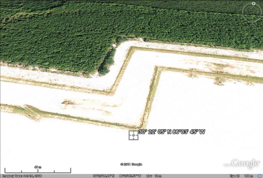
From Page 6 of the permit here: http://appprod.dep.state.fl.us/nwu/Point_Washington_FLA010252_022_NR_Permit.pdf
The rapid infiltration basins are located approximately at latitude 30° 22′ 05″ N, longitude 86°03′ 45″ W.”
Led Zeppelin’s Stairway to Heaven.
This may be off topic, but as one example of anomalous features near water (they seem in my experience so far to be around water), see these locations on Google Earth:
70°59’N 156°38’W (near Point Barrow, Alaska)
73°30’N 124°35’E (in the apparent delta of the Lena River, in Siberia)
The aligned lakes in both areas are unexplained, thus far. They were sighted by pilots overflying the area. People have put forth speculation on their provenance, but nothing is definitive at present.
To me, the lakes look like some sort of spongiform rock formations, but I only throw that out as a starting point. Note that, though the Lena lakes are clearly in the delta of the river, the flowage of the river mouths almost all seem to bypass the lakes on their way to the nearby Arctic Sea.
And if anyone is interested in such things, look up “Carolina bays.” (Those were also first recognized by overflying pilots.)
Anthony, if this is a digression on this post, may I suggest you post about them, as part of your scientific curiosity that underlies the website?
“there appear to be sand piles that make the step shapes?”
It’s the stairway to Heaven for the rapture revellers
Oh, BTW, using the GE Elevation tool on Anthony’s odd formation, it seems to indicate that the area is RAISED. Its elevation is generally about 40 feet above sea level, while the surrounding land is indicated as about 32-37 feet. I wouldn’t trust this tool by itself, but it may be correct.
Oops – sorry about the size of that.
Florida is little more than a sandbar piled with seashells. Anywhere you go there, you dig away the vegetation, and the “soil” is white. As for purpose, I’ll go with modern day “Chariots of the Gods” hieroglyph.
The property, consisting of 2 parcels; parcel # 32-2S-18-15000-001-0000 (70 acres) & parcel # 33-2S-18-15000-001-0000 (30 acres) belongs to Walton County Florida (deeded in Dec 2002). Property usage is listed as vacant government.
http://64.234.218.210/cgi-bin/walton_display.cgi?KEY=32-2S-18-15000-001-0000
http://64.234.218.210/cgi-bin/walton_display.cgi?KEY=33-2S-18-15000-001-0000
Not mysterious but strange and pretty: Southwest Kansas, where circular irrigation intersects property lines and roads and streams in a wildly complex set of Venn diagrams.
Start from Bucklin, near Dodge City.
Early alien art was done under the influence of LSD resulting in chaotic designs. They changed to schrooms and discovered circles work better.
dang verity, that takes all the fun out of it.
I was going to go with the abandoned film site for the movie Tron.
Even bigger mystery – why the heck did they build it that shape?
Thanks for elevating this, Anthony. I posted it and had a little discussion about it on your post about the desert triangle. Someone concluded it was a recent clearcut. But, I don’t understand why the brush was bulldozed in perfectly straight lines that would have required a surveying team. This has been puzzling me for a couple of years. So much so that I might just drive down there and check it out this coming weekend.
@Juice
Most all of north Florida is a “tree farm”.
The river several have referred to is the intercoastal waterway. The river to the north is the Choctawhatchee, which flows into Choctawhatchee bay.
Here is the google map link. Interestingly, if you back out one increment, it disappears. This suggests to me that the zoomed out picture is older than the zoomed in picture.
http://maps.google.com/maps?hl=en&ie=UTF8&ll=30.363544,-86.059341&spn=0.062801,0.106258&t=h&z=13
Just a caution, if I may. Anthony, you presented a Google Earth image (same as in a post last week) and asked what it was. There is a difference between asking what it was, and what it is going to be. To discover what it is going to be requires research into planning documents etc and an assumption that having got this far, it will move to something else.
The “this far” was, as I blogged, a clear felling of trees in a forest. The striations in the forest show it was a plantation. In the 2003 image, you can see the piles of cut tree waste that remained.
That was the right answer for the time.
To state as others have done that it will be a treatment plant or whatever requires not only information absent from the images, but knowledge that the project will proceed. Since the image taken about 2003 is the first to show this clearing, and since more recent images do not show much change except grass invasion and erosion of sharp features, can I suggest that some readers are falling into the climate prediction trap of projecting on the basis of inadequate data?
It’s 8 years or more since the pattern was made, so I suppose we have to wait for another 22 years so we can be sure it’s ‘climate’ and not ‘weather’.
If you turn it 90 degrees clockwise you being given the finger 🙂
My guess would be a water treatment plant of solid landfill, as it looks much like the landfill just to the east, complete with the twin rows of berms surrounding the center area. I’ll go with landfill just starting construction.
It’s an Obamanation.
If you rotate it 90 degrees counter clockwise, I believe it is a chart of the value of my 401k plan
Looks like a step function to me.
The greenies are just trying to increase the albedo of the earth to cool down all the global warming that’s going on. Wait until that white blight grows to encompass the entire globe!
The following topographic map shows there used to be a bunker site immdeiately west of the new site. A map from the Choctawhatchie Water Management District indicates the new site’s boundaries is a “Private” area enclosed within the Choctawhatchie WMD. Another map regarding Walton County and its landfills indicates there is a C&D landfill (Constructon and Demolition debris) in the general area. However, a local newspaper article said there were only three Walton County C&D landfills, and its map displayed them all in the northern end of the county, and not in the area of the previous map. This raises the question of whether or not the object n question is a new bunker system replacing the older bunker site taken into the Choctawhatchie WMD, a new C&D landfill under in its early phases, or something else altogether?
http://www.trails.com/topo.aspx?panerror=true&z=16&e=586111.843519074&n=3360139.78142845&s=50&size=s&style=drgsr
Point Washington Topo Map at Lat 30.3701°N Long -86.1038°W Zoom 15 S Size
Center: 30.3693°N 86.0875°W
Elevation at center: 26 feet (8 meters)
Quad: Pensacola
Drg Name: c30086a1
Drg Source Scale: 1:250,000
Projection: NAD83/WGS84
“There’s going to be a guy’s house in the middle, and he’s making sure the bulk of his flood protection berms are solid before he even starts construction.”
Yeah but, yeah but…..if another slow moving Tropical Storm Fay comes along an dumps around 40″ of rain like it did in Melbourne…..he’s got a house in the middle of a swimming pool. Maybe a minimum 6″ slope per 100′ should drain well though.
This is a storage unit development.
Verity Jones says:
May 22, 2011 at 5:57 pm (Edit)
Even bigger mystery – why the heck did they build it that shape?
Maintaining flow velocity and a reasonably constant distance from the road?
(less turbulance caused by straight runs and tight bends than by long radii)
Remember that the Rapture was not supposed to be the end of the world. The Rapture was the time when all the worthy people were to be removed so that they would not have to endure all the crap involved in the end of the world.
Since you are still here, and so are all of your relatives, friends and aquaintances and me; that just means that we didn’t make the cut. Neither did anyone else.
🙂
It’s a coral bleaching facility.
After treatment of the coral they dump it on reefs to enhance the fear for CAGW.
Website has solved this one, waste water treatment overflow seepage field.
Someone drew a large maze? Difficulty level -1
It’s the naughty step where skeptics have to sit until they reform their bad ways.
worlds largest (and slowest) game of Tetris.
@Geoff Sherrington:
Not sure it was exactly the right answer for the time. If it had been felled as normal, it would have been re-planted and be as green as the surrounding forest by now. And, there would have been none of the precision. This required a professional survey crew working in conjunction with the bulldozers to accomplish.
Sorry, I though it was some kind of grand flow chart for Green policies, because it started with a dead end, it twists & turns here & there, then ends in a dead end!:-)
Bob Diaz, you had me laughing out loud.
Glacial lakes. Lakes are geologically temporary, because they fill up, so all those lakes were created recently. Those areas were covered with glaciers a few thousand years ago. They’re all elongated in the same direction because that’s the direction the glacier was flowing — or the other way glaciers are formed, because that’s downhill. Glaciers form lakes through two mechanisms – by scraping out holes, or by creating the high land around what becomes the lakes. Why lakes are created by digging holes is obvious. Glaciers creating high ground is less obvious.
One way that glacial ridges are created is by water flowing under the glacier; they’re basically stream beds with stones accumulating on the bottom, except these streams can grow tall if they melt through the ice above, forming a ridge of stones (with ice on both sides) and water flowing through the stones and above it. More stones get melted out of the ice above and next to the stream, adding to the stream bed. Parallel ridges can be formed because the streams all tend to flow downhill.
It’s a ball field for the January 2013 New Mayan Games.
Obvious evidence that God was too busy with his etch – a – sketch to bother with the rapture. Maybe next time.
I did have the thought at one time there was a massive drug interdiction radar site around there somewhere and maybe this is google’s way of covering it up???
@Steve Garcia
Hopefully, your friend in PC can get some ground level shots. I’ve had many people warn me over the years to stay off the dirt roads in this part of the country lest you run up on business being conducted that you don’t want to know about. Otherwise, I’d have already checked it out.
Nearly perfect right angles, as in the photo, are not very common in Nature. One example: NaCl (aka salt) crystals.
Some Northern California hikers–including myself–know of another example. Although there are no dolmens–or even standing stones–we sometimes call it the “California Stonehenge”. It’s in an area of glacier-polished granite of mostly one shade. Running through this granite is a Dike or Sill, having a different shade. (I’m igneous about which is the correct geological term.) Here’s how it probably formed.
Millions of years ago, the granite was covered by soil. There was pressure from below. The granite cracked, and magma filled in the crack. Over time, the magma cooled slowly, because the soil on top acted as insulation. This promoted the formation of the small, well-defined crystals that characterize granite. The newer granite was not the same shade as the older. Then some time within the last 5 million years, a mountain glacier eroded the soil away, leaving this geological formation behind.
Here’s the interesting part. The sill runs in a straight line segment for awhile; then it makes a nearly perfect right-angle turn, and continues on in another straight-line segment. When I first saw it, I thought that Nature was playing a joke on us.
The “California Stonehenge” is in a canyon in the Northern Sierras, just off of Highway 88. Since there is no trail, the hike in is cross-country, with some bushwhacking, and with a respectable amount of elevation gain on the way out.
If some Sacramento-area WUWT photography buffs express an interest, I could be persuaded to lead a hike there later in the season. Late September would be good time for this. The mosquitoes should be gone by then. We could even have an informal Equinox celebration. Druid costumes optional. My email is wimpehiker@yahoo.com.
This place?
http://www.jarvisgallery.com/sierra-club-event-stonehenge-rocks
Hey! Get off my lawn!
Damn kids.
D. Patterson says:
May 24, 2011 at 2:12 pm
This place?
http://www.jarvisgallery.com/sierra-club-event-stonehenge-rocks
No, the ‘California Stonehenge’ is West and a bit South of there, near Silver Lake. However my first visit to the California Stonehenge was on a Sierra Club hike many years ago.
When mentioning the possibility of an Equinox Celebration there, I should have emphasized the bushwhacking aspect a bit more. If you bring a costume, it should be stuffed inside your rucksack. While hiking, you’ll probably want to wear blue jeans or work pants. Otherwise you’ll get scratches on your legs.