Now that we all survived the rapture, readers are invited to help figure out what this is.

Details here: It is cut out of the Florida forest, the white surface is sand, and there appear to be sand piles that make the step shapes?
http://dailygoogleearth.com/ has the location and details.
There appear to be ramps passing over the berms at an angle that allow vehicles to enter the enclosures. If you zoom in, there are some strange structures near the ramps, on each side of the berm. Rows of three dots. Pipes? And there is some sort of central circular mound.
It’s next to a canal connecting Fort Walton Beach and Panama City. There seem to be somwhat similar enclosures all along the canal. If you follow the canal east, guess what? Now we know where the boondocks are (is?). It’s Boon Docks, right there.
Some sort of alien kids’ video game? Their kids have to have something to do. Life gets boring travelling all over hyperspace. And Florida is such a nice place anyway.
The USGS topographic maps have it marked as a storage bunker location in the Devil’s Swamp North of Bunker Road, East of Port Washington, Florida. The roads link it to barge traffic on the Intracoastal Waterway. Tyndall AFB, Elgin AFB, and Pensacola NAS are nearby.
If you zoom out you can see lots of that white sand along the waterway probably where they stockpile dredged sand from waterway maintanance
Phosphate mine.
Zoom in closer and the lines are not walls or anything like that. There are no shadows like there are from the trees on the edge.
I will guess either some sort of agriculture experiment or the outline of a foundation for a really big building.
That’s easy. It’s the Green Party’s international headquarters, with the roof being white so as to reflect the heat back into space, and the strange shape being the landing pad for the alien mothership. The greenies had to overcome their natural revulsion for using white to reflect the heat (as it was racist), but it was the only colour that worked.
Oh, that’s easy, that’s the environmentally friendly landing strip for totally righteous pot smoking hippie dudes green aliens from la la land, dude.
Team crossword puzzle [no two words actually cross, it’s only a model].
What? We survived the rapture? Are you sure? How can you tell the difference? I think we need to get a concensus opinion on that before we rush to judgment.
Something else to consider … if the end of the world comes won’t that lead to massive extinction of species? Shouldn’t the EPA be regulating that? Certainly there must violate some federal statute on it.
It’s the new Lego factory.
Isn’t it a salt/sand quarry or salt lagoon?
Simple – its a crashed tetris 🙂
You are all wrong.
It’s actually the site prep for the 2012 IPCC conference. It’s artistically laid out to represent the latest GISS model output vs actual C20th temps.
Tree farm?
The trees all around it are arranged in neat rows.
It’s not limestone. The white color is sand. It’s one a river delta next to beaches.
Last year I got involved with someone who “found” three or four types of very anomalous land/water features (which were interpreted initially as some sort of canals, all along the Gulf Coast and also along the Atlantic Coast). Eventually, I was able to determine that the vast majority of the features were a.) mosquito ditches for mosquito abatement projects, b.) canals dredged for oil exploration, for moving floating drilling platforms around, prior to the development of sideways drilling, and c.) muskrat dens.
On Google Earth, all these features were extremely puzzling, and all kinds of ideas were floated.
In the end, I came to the conclusion that Google Earth images are not to be trusted, that they can give false impressions of what we are looking at.
Though seemingly really weird, this will – IMO – turn out to be something that we will learn something from – but will not have thought of. Industry and towns/counties/states do things that make all the sense in the world – once it is explained to us.
I suggest simply calling the local government and asking. If they themselves don’t know, they will be able to point to someone who can.
I have a friend in nearby Panama City whom I’ve asked to drive over and see it, if he can get close enough. I will advise, if he is able to.
The three “pumps” on each “snake” could be a clue to something wet being deposited there.
Fish farm?
tallbloke says:
May 22, 2011 at 3:57 pm
lol
Mystery solved. It is part of the Point Washington wastewater treatment facility; you can see the main plant over the river at 30°21’18.88″N, 86° 6’40.24″W if you zoom out.
From Page 6 of the permit here: http://appprod.dep.state.fl.us/nwu/Point_Washington_FLA010252_022_NR_Permit.pdf
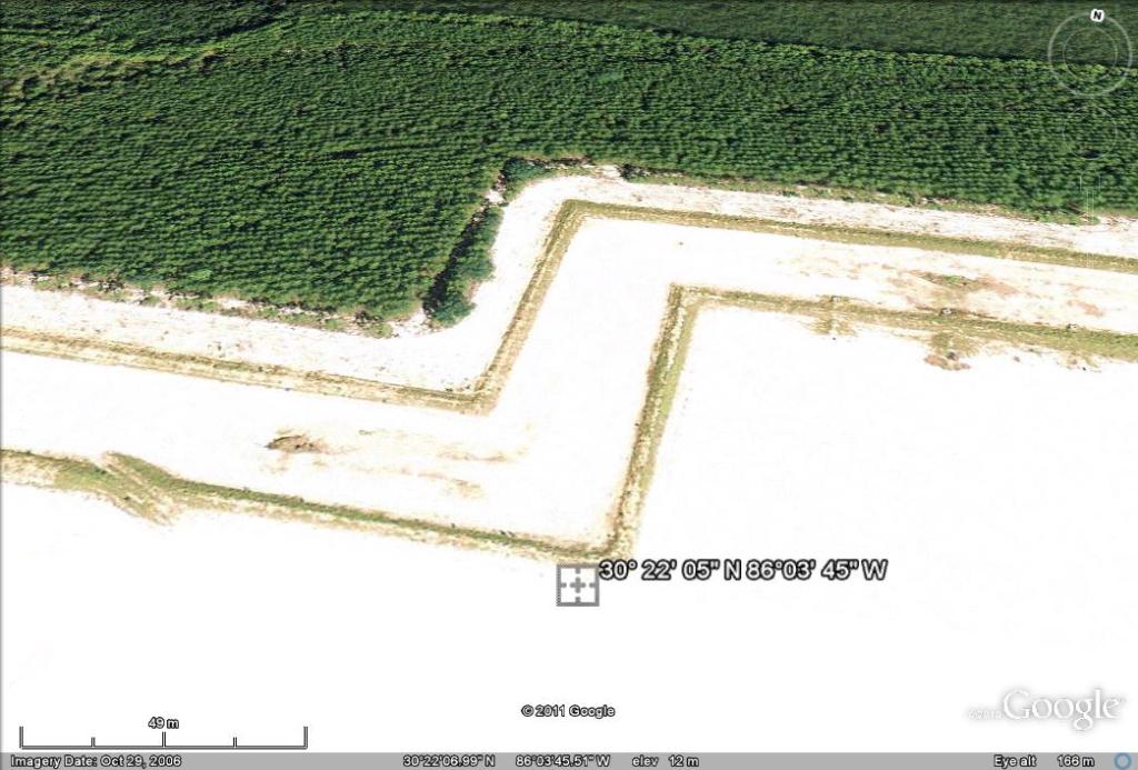
The rapid infiltration basins are located approximately at latitude 30° 22′ 05″ N, longitude 86°03′ 45″ W.”
Led Zeppelin’s Stairway to Heaven.
This may be off topic, but as one example of anomalous features near water (they seem in my experience so far to be around water), see these locations on Google Earth:
70°59’N 156°38’W (near Point Barrow, Alaska)
73°30’N 124°35’E (in the apparent delta of the Lena River, in Siberia)
The aligned lakes in both areas are unexplained, thus far. They were sighted by pilots overflying the area. People have put forth speculation on their provenance, but nothing is definitive at present.
To me, the lakes look like some sort of spongiform rock formations, but I only throw that out as a starting point. Note that, though the Lena lakes are clearly in the delta of the river, the flowage of the river mouths almost all seem to bypass the lakes on their way to the nearby Arctic Sea.
And if anyone is interested in such things, look up “Carolina bays.” (Those were also first recognized by overflying pilots.)
Anthony, if this is a digression on this post, may I suggest you post about them, as part of your scientific curiosity that underlies the website?
“there appear to be sand piles that make the step shapes?”
It’s the stairway to Heaven for the rapture revellers
Oh, BTW, using the GE Elevation tool on Anthony’s odd formation, it seems to indicate that the area is RAISED. Its elevation is generally about 40 feet above sea level, while the surrounding land is indicated as about 32-37 feet. I wouldn’t trust this tool by itself, but it may be correct.
Oops – sorry about the size of that.