Go here and here for background information on Polar Vortices.
Wind
Southern Polar Wind – It is recommended that you click down through each height in succession so that you can see polar vorticity with depth:
10 hPa/mb – Approximately 31,000 meters (101,700 feet) Wide and Focused Perspective
70 hPa/mb – Approximately 18,000 meters (59,000 feet) Wide and Focused Perspective
250 hPa/mb – Approximately 10,400 meters (34,000 feet) Wide and Focused Perspective
Geopotential Height
Southern Hemisphere – Vertical Cross Section of Geopotential Height Anomalies (Polar Vortex):
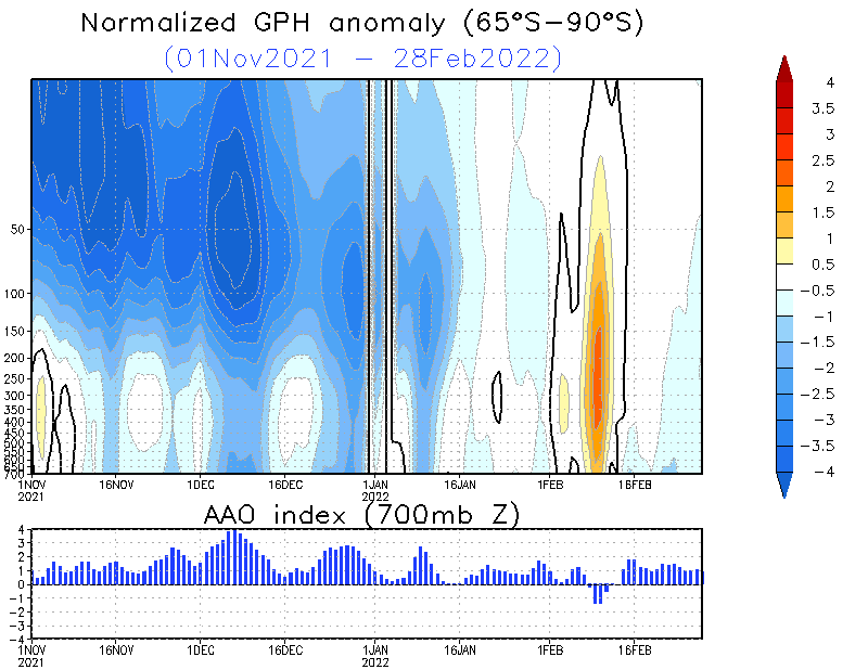
NOAA – National Weather Service – Climate Prediction Center – Click the pic to view at source
1 hPa/mb Height Analysis – Approximately 50,000 meters (164,000 feet):

NOAA – National Weather Service – Climate Prediction Center – Click the pic to view at source
2 hPa/mb Height Analysis – Approximately 42,500 meters (140,000 feet):

NOAA – National Weather Service – Climate Prediction Center – Click the pic to view at source
5 hPa/mb Height Analysis – Approximately 35,000 meters (115,000 feet):

NOAA – National Weather Service – Climate Prediction Center – Click the pic to view at source
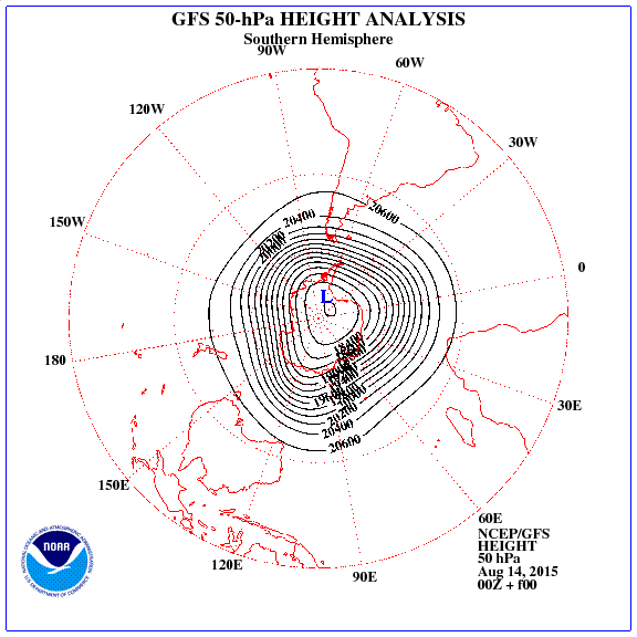
10 hPa/mb Height Analysis – Approximately 31,000 meters (101,700 feet):

NOAA – National Weather Service – Climate Prediction Center – Click the pic to view at source
30 hPa/mb Height Analysis – Approximately 23,700 meters (77,800 feet):

NOAA – National Weather Service – Climate Prediction Center – Click the pic to view at source
50 hPa/mb Height Analysis – Approximately 20,100 meters (66,000 feet):
NOAA – National Weather Service – Climate Prediction Center – Click the pic to view at source
70 hPa/mb Height Analysis – Approximately 18,000 meters (59,000 feet):

NOAA – National Weather Service – Climate Prediction Center – Click the pic to view at source
100 hPa/mb Height Analysis – Approximately 15,000 meters (49,000 feet):
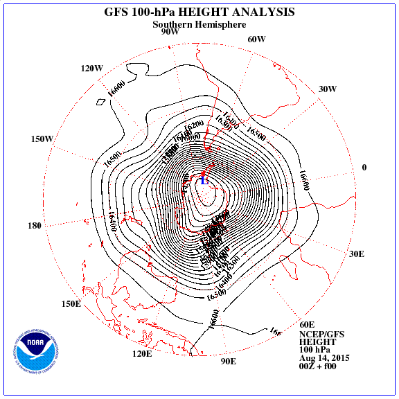
NOAA – National Weather Service – Climate Prediction Center – Click the pic to view at source
Global – 200 hPa/mb Height Anomalies – Atmospheric Pressure Anomalies at Approximately 12,000 meters (40,000 feet):

NOAA – National Weather Service – Click the pic to view at source
Southern Hemisphere – 500 hPa/mb Height Anomalies – Atmospheric Pressure Anomalies at Approximately 5,500 meters (18,000 feet):

NOAA – National Weather Service – Climate Prediction Center – Click the pic to view at source
Southern Hemisphere – 500 hPa/mb Geopotential Height and Vorticity – Approximately 5,500 meters (18,000 feet):

Center for Ocean-Land-Atmosphere Studies (COLA) – Institute of Global Environment and Society (IGES) – Click the pic to view at source
Temperature
1 hPa/mb Temperature Analysis – Approximately 50,000 meters (164,000 feet):

NOAA – National Weather Service – Climate Prediction Center – Click the pic to view at source
2 hPa/mb Temperature Analysis – Approximately 42,500 meters (140,000 feet):

NOAA – National Weather Service – Climate Prediction Center – Click the pic to view at source
5 hPa/mb Temperature Analysis – Approximately 35,000 meters (115,000 feet):

NOAA – National Weather Service – Climate Prediction Center – Click the pic to view at source
10 hPa/mb Temperature Analysis – Approximately 31,000 meters (101,700 feet):
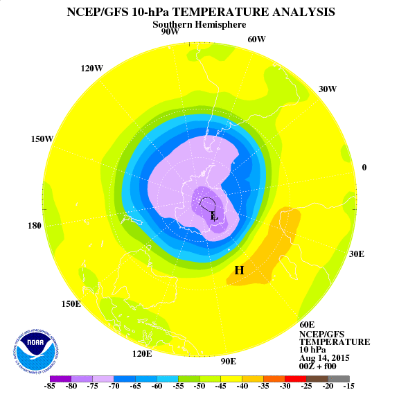
NOAA – National Weather Service – Climate Prediction Center – Click the pic to view at source
30 hPa/mb Temperature Analysis – Approximately 23,700 meters (77,800 feet):
NOAA – National Weather Service – Climate Prediction Center – Click the pic to view at source
50 hPa/mb Temperature Analysis – Approximately 20,100 meters (66,000 feet):

NOAA – National Weather Service – Climate Prediction Center – Click the pic to view at source
70 hPa/mb Temperature Analysis – Approximately 18,000 meters (59,000 feet):

NOAA – National Weather Service – Climate Prediction Center – Click the pic to view at source
100 hPa/mb Temperature Analysis – Approximately 15,000 meters (49,213 feet):

NOAA – National Weather Service – Climate Prediction Center – Click the pic to view at source
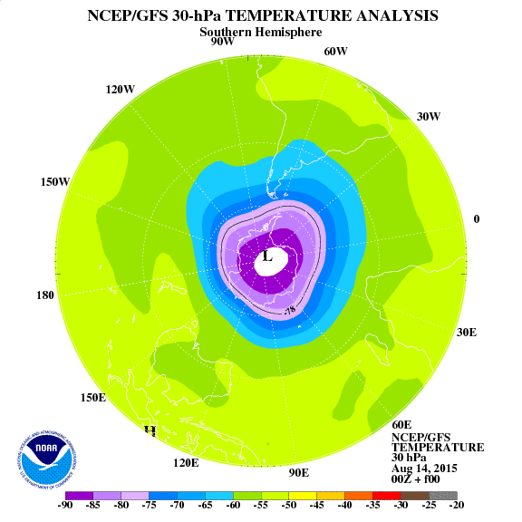
Southern Hemisphere Area Where Temperature is Below 195K or -78°C (Temperature below which Polar Stratospheric Clouds May Form):

NOAA – National Weather Service – Climate Prediction Center – Click the pic to view at source
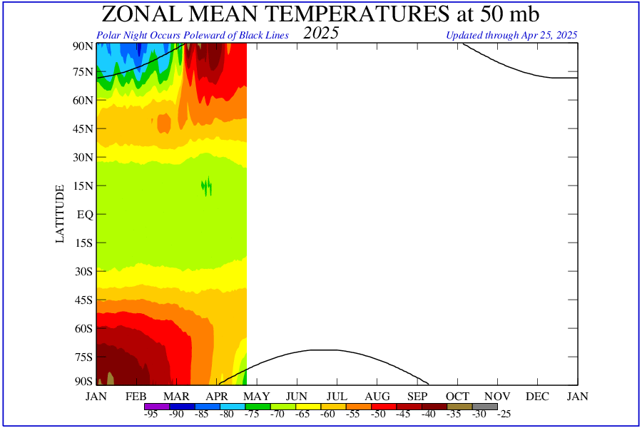
Zonal Temperature Anomaly Time Series:

NOAA – National Weather Service – Climate Prediction Center – Click the pic to view at source | → CPC Stratosphere-Troposphere Monitoring
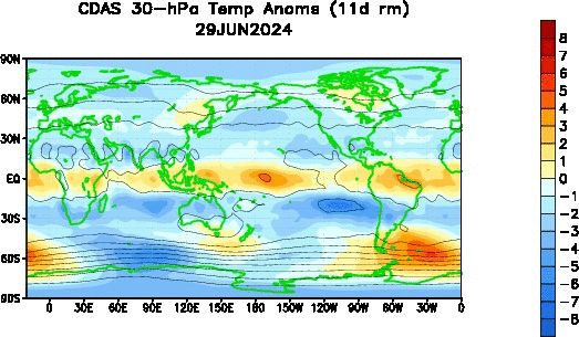
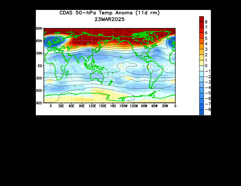
50 hPa/mb Zonal Mean Temperature Anomalies – Approximately 20,100 meters (66,000 feet):
NOAA – National Weather Service – Climate Prediction Center – Click the pic to view at source
Global – 10 hPa/mb Height Temperature Anomalies – Atmospheric Temperature Anomalies at Approximately 31,000 meters (101,700 feet):

NOAA – National Weather Service – Climate Prediction Center – Click the pic to view at source
Global – 30 hPa/mb Height Temperature Anomalies – Atmospheric Temperature Anomalies at Approximately 23,700 meters (77,800 feet):
NOAA – National Weather Service – Climate Prediction Center – Click the pic to view at source
Global – 50 hPa/mb Height Temperature Anomalies – Atmospheric Temperature Anomalies at Approximately 20,100 meters (66,000 feet):
NOAA – National Weather Service – Climate Prediction Center – Click the pic to view at source
Southern Polar Temperature Lower Stratosphere (TLS) – 1979 to Present:
RSS/AMSU lower stratosphere temperature time series for the Southern Polar region are available via the RSS interactive browser. Select Channel TLS (v4.0) and Region South Polar.
→ Open RSS MSU/AMSU Time Series Browser
Remote Sensing Systems (RSS) – Microwave Sounding Units (MSU/AMSU)
Ozone
Ozone Mixing Ratio map showing a slight “Ozone Hole” within the Vortex:
1 hPa/mb Ozone Mixing Ratio – Approximately 50,000 meters (164,000 feet):

NOAA – National Weather Service – Climate Prediction Center – Click the pic to view at source
2 hPa/mb Ozone Mixing Ratio – Approximately 42,500 meters (140,000 feet):

NOAA – National Weather Service – Climate Prediction Center – Click the pic to view at source
5 hPa/mb Ozone Mixing Ratio – Approximately 35,000 meters (115,000 feet):

NOAA – National Weather Service – Climate Prediction Center – Click the pic to view at source
10 hPa/mb Ozone Mixing Ratio – Approximately 31,000 meters (101,700 feet):

NOAA – National Weather Service – Climate Prediction Center – Click the pic to view at source
30 hPa/mb Ozone Mixing Ratio – Approximately 23,700 meters (77,800 feet):

NOAA – National Weather Service – Climate Prediction Center – Click the pic to view at source
50 hPa/mb Ozone Mixing Ratio – Approximately 20,100 meters (66,000 feet):

NOAA – National Weather Service – Climate Prediction Center – Click the pic to view at source
70 hPa/mb Ozone Mixing Ratio – Approximately 18,000 meters (59,000 feet):

NOAA – National Weather Service – Climate Prediction Center – Click the pic to view at source
100 hPa/mb Ozone Mixing Ratio – Approximately 15,000 meters (49,213 feet):

NOAA – National Weather Service – Climate Prediction Center – Click the pic to view at source
Southern Hemisphere Total Stratospheric Ozone:
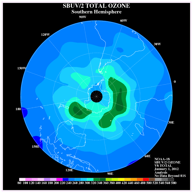
NOAA – National Weather Service – Climate Prediction Center – Click the pic to view at source
Planetary Waves
Zonal Wave #1 Amplitude Time Series:

NOAA – National Weather Service – Climate Prediction Center – Click the pic to view at source | → CPC Stratosphere-Troposphere Monitoring
Zonal Wave #2 Amplitude Time Series:

NOAA – National Weather Service – Climate Prediction Center – Click the pic to view at source | → CPC Stratosphere-Troposphere Monitoring
Coriolis Torque
Vertical and Zonal Integral of Coriolis Torque:

NOAA – Physical Sciences Laboratory (PSL) – Click the pic to view at source
Mountain Torque
Vertical and Zonal Integral of Mountain Torque:

NOAA – Physical Sciences Laboratory (PSL) – Click the pic to view at source
Eddy Heat Flux
10 Day Averaged Eddy Heat Flux Towards The South Pole at 100mb:

NOAA – National Weather Service – Climate Prediction Center – Click the pic to view at source | → CPC Stratosphere Monitoring
Atmospheric Transmission of Solar Radiation
UV Erythemal Daily Dosage:
NOAA – National Weather Service – Climate Prediction Center – Click the pic to view at source
Source Guide
Center for Ocean-Land-Atmosphere Studies (COLA) – Institute of Global Environment and Society (IGES)
Home Page – https://wxmaps.org/pix.html
Height and Vorticity Analyses – https://wxmaps.org/pix/analyses.html
Hurricane Potential – https://wxmaps.org/pix/hurpot.html
Forecast Page – https://wxmaps.org/pix/forecasts.html
NOAA – Physical Sciences Laboratory (PSL) (formerly Earth System Research Laboratory / ESRL)
Home Page – https://psl.noaa.gov/
Products Page – https://psl.noaa.gov/products/
Data Page – https://psl.noaa.gov/data/
Maps Page – https://psl.noaa.gov/map/
NOAA – National Centers for Environmental Information (NCEI) (formerly National Climatic Data Center / NCDC)
Home Page – https://www.ncei.noaa.gov/
Products Page – https://www.ncei.noaa.gov/products
NOAA – National Weather Service – Climate Prediction Center (CPC)
Home Page – https://www.cpc.ncep.noaa.gov/
Stratosphere Monitoring – https://www.cpc.ncep.noaa.gov/products/stratosphere/polar/polar.shtml
Stratosphere-Troposphere Monitoring – https://www.cpc.ncep.noaa.gov/products/stratosphere/strat-trop/
Atmospheric & SST Indices – https://www.cpc.ncep.noaa.gov/data/indices/
Regional Climate Maps – https://www.cpc.ncep.noaa.gov/products/analysis_monitoring/regional_monitoring/
Weather Models – Ryan Maue’s Weather Maps (NCEP GFS, NAM, and ECMWF)
https://weathermodels.com/
Remote Sensing Systems (RSS)
Home Page – https://www.remss.com/
Upper Air Temperature (MSU/AMSU) – https://www.remss.com/measurements/upper-air-temperature/
Time Series Browser – https://images.remss.com/msu/msu_time_series.html
StormSurf.com
Home Page – https://www.stormsurf.com/
Model Products Page – https://www.stormsurf.com/mdls/menu.html
Global Jet Stream Wind and 250 mb Pressure – https://www.stormsurfing.com/cgi/display_alt.cgi?a=glob_250
North Atlantic Surface Pressure and Wind – https://www.stormsurfing.com/cgi/display.cgi?a=natla_slp
Very interesting, thank you.
Readers are reminded that “changes” in the (southern) polar vortex (due to climate change) are regularly blamed for the many years of steadily increasing Antarctic sea ice extents and sea ice area surrounding Antarctica. Supposedly, the increased winds blow the sea ice away from the shoreline, opening up new ocean water to the fresh water-diluted Antarctic Ocean surrounding the continent (the increased fresh water volume being due to the increased melting of the Antarctic land ice), and thus allowing sea ice to freeze. Winds increase again, get blow away from the continent, more sea ice freezes.
The concept does not make sense thermodynamically, nor physically – since the air temperature above Antarctica has been decreasing, the polar vortex winds have not been increasing, and the mass of land ice above the continental land mass has been increasing everywhere except the 4% of land in the West Antarctic Peninsula. (Which is the only area on the continent that is warming.) Further, the small bit of “fresh water” that does melt under glacier ice on the continental edge immediately re-freezes as long runnels of ice underwater as soon as it hits the below-freezing (very salty) ocean water around the coasts. It cannot dilute the tens-of-thousands-times larger Antarctic Ocean surrounding the continent.
This reference page will be a very useful source.