Guest Essay by Dr Alan Welch FBIS FRAS, Ledbury, UK — 29 June 2022

Abstract: There is a strong probability that the “accelerations” predicted by Nerem et al in their 2018 Paper (1) are due to the method of calculation and not inherent in the data. In this essay a number of data sets associated with sea level rises have been studied. The data are systematically split into a range of shorter periods and analysed using a quadratic fit in line with the method used in Nerem et al. The resulting “accelerations” and “deaccelerations” are plotted against the time period analysed in years and a power curve fitted to a plot of absolute “accelerations”.
———————————————————————-
There is a strong probability that the “accelerations” predicted by Nerem et al in their 2018 Paper (1) are due to the method of calculation and not inherent in the data. Also, in Nerem et al (2022) (2) it is stated that the “accelerations” have stabilized where in reality there has been a drop of over 10% in the 26 months since the “accelerations” peaked in Jan 2020. See “Sea Level Rise Acceleration – An Alternative Hypothesis” (3) for an essay on Nerem’s methodology. As a consequence, can anything be learnt by studying other longer sea level rise data sets in more detail?
In earlier preliminary studies of a range of sea level data some common features were noticed.
- For very long (over 100 years) the “accelerations” tended towards zero and generally were of the order of 0.01 mm/year2. Whether such low “accelerations” are actual physical accelerations, per se, or manifestations of the method of measurement or calculation is difficult to apprehend, especially if very long behaviour (over millennium) is involved.
- As time periods of analysis reduce (either due to shorter data sets or reduced period of analysis) perceived “accelerations” tend to increase.
- As well as “accelerations”, “deaccelerations” start to emerge.
- At short periods of analysis, the “accelerations” and “deaccelerations” grow rapidly and become numerically similar.
To understand all of these a common form of presentation would be useful.
The following generic presentation was devised.
- Calculated “accelerations” and “deaccelerations” are plotted against time-period covered by the analysis.
- Absolute values of “accelerations” and “deaccelerations” are plotted against time-period covered by the analysis. These are either the whole period or fractions down to 1/16th of the whole period.
- A power curve is fitted to the plot of absolute values. The choice of a power curve is appropriate in cases where there may be a relationship between two variables. The article on Wikipedia is a useful guide as to the universal suitability of this equation (https://en.wikipedia.org/wiki/Power_law). This procedure is not exactly correct as the “accelerations” and “deaccelerations” would be distributed about a long-term asymptotic value but as this may be of the order of 0.01 mm/year2 the effect would be negligible. The power curves derived are asymptotic to zero.
Below are two graphs (Figure 1) illustrating this process.

Figure 1
The first data sets studied are, together with an abbreviated reference label in parenthesis: –
The Brest Tidal Gauge data. (BREST)
The Tidal Gauge data released in 2013 by CSIRO. (CSIRO) *
The NASA Satellite data from the start 1993 to the end of 2021 for comparison. (NASA)
The 375 Tidal Gauge readings listed by NOAA. (NOAA) *
And after investigating these a further two cases were studied : –
A simulated set of data (SIM)
The Swinoujscie (Poland) data that covers 188 years (Swin).
* As these involve input from many tidal gauges over different periods care must be exercised in judging the results. For example, the tidal gauges having shorter range of dates may be the most recent and so may bias the study and conclusions.
Before proceeding with the analysis some general remarks.
In most calculations of “acceleration” use is made of quadratic curve fitting. To misquote JFK this is “not because it is difficult but because it is easy”. Any “acceleration” derived is indicative of the average over the period being considered. If the curve was a long term (millennium) variation, which in many cases is just as good a fit, the “acceleration” would be varying with time. Superimposed on top of this can be sinusoidal variations on several decade time scales. These are not part of the sea level rise but occur due to the method of measurement and the coverage.
Previous studies of the CSIRO and NASA data showed that each may contain a superimposed sinusoidal variation that causes relatively high “accelerations”. For the Tidal Gauges the underlining overall quadratic curve points to an average “acceleration” of 0.0126 mm/year2. A superimposed sinusoidal curve of +/- 6mm over a 57-year period causes additional short-term accelerations of about +/- 0.07 mm/year2 over a few years. Figure 2 below shows a combined plot against actual readings.

Figure 2
This was similar to the paper “Is there a 60-year oscillation in global mean sea level” by Chambers, Merrifield and Nerem [4]. They quoted a range of variations for oceans of between 50 to 59-year periods and a wide range of amplitudes. There was also a wide variation in phases for the different oceans so the above derived 57-year period/6 mm amplitude curve may be a reasonable average effect. Some papers suggest that the total curve can be split into a number of linear portions. See Figure 3 below taken from, Hansen et al (2015) (5). Nature would tend to smooth off such linear variations.

Figure 3
For the NASA Satellite readings there could be a sinusoidal variation about the linear best fit of +/- 3.5mm over a 25-year period that causes additional short-term accelerations of nearly +/- 0.30 mm/year2. Figure 4 below shows a combined plot against actual readings.

Figure 4
These short periods of much higher accelerations would impinge on any short periods analysed.
Figures 2 and 4 are based on my 2018 unpublished paper “Accelerating Sea Level Rise – Reconciliation of Tidal Gauge readings with Satellite Data” in which I first tried to formulate my ideas having read Nerem et al (2018).
The first 4 data sets listed above were analysed over a range of periods and graphs produced of “accelerations” and absolute values, the later also showing power curve trendlines. The 2 sets of 4 graphs are shown in figures 5 and 6.

Figure 5

Figure 6
Discussion
Brest Tidal Gauge
The total period covered by the Brest data is 211 years but due to the large gap in readings prior to 1850 only the data from 1850 to 2018 are considered. Periods analysed may vary slightly due to small gaps in the readings or where major gaps occur the affected 10.5-year periods were ignored. The “acceleration” at 168 years is 0.0108 mm/year2. At shorter periods there is a similar spread of “accelerations” and “deaccelerations”.
Apart from 1 high short period “acceleration” (investigated later) the values generally show equal levels of “acceleration” and “deacceleration”. The value of “acceleration” at the end of the trend line is 0.00994 mm/year2, very similarto the actual calculated value of 0.0108 mm/year2. The power exponent of -1.603 implies halving the time-period would increase, on average, the calculated absolute acceleration by a factor of approximately 3.
The Brest data also shows some interesting observations. As stated above the “acceleration” derived from fitting a quadratic to the Brest data between 1850 and 2018 (168-year period) is 0.0108 mm/year2. Splitting the data into 2 equal 84 year periods produces “accelerations” of 0.044 and 0.045 mm/year2 respectively. Analysing an 84-year period from 1892 to 1976, i.e. midway in the data produces a “Deacceleration” of -0.045 mm/year2. All these 3 values are roughly equal, which may be coincidental, but more importantly they are all about 4 times the 168-year value. If halving the time period can invoke such a dramatic increase in perceived acceleration what chance do even shorter periods have of giving any sensible values. These analyses are shown in Figure 7.

Figure 7
It was also pointed out that there was one “acceleration” over a period of 10.5 years that was much higher. Around 1912 the sea levels were recorded as extra high and the 10.5 year period covering 1912 had this higher sea levels at one end. As a result the “acceleration” derived was 6.04 mm/year2, over 500 times the 168 year result. Moving the period covered on by 4 years causes the high “acceleration” to become a high “deacceleration” of 7.56 mm/year2 as shown in Figure 8. This indicates how short periods can totally distort any “acceleration” estimations. Imagine extrapolating either of the 2 curves in Figure 8 for 100 years. The sea would rise over 36m or fall over 39m!

Figure 8
CSIRO Data
The next study involves the Tidal Gauge results the data for this having been extracted from an earlier version of the https://climate.nasa.gov/vital-signs/sea-level/ site and referenced to CSIRO as its source. The data file extracted from the CSIRO source was labelled “CSIRO_Recons_gmsl_mo_2015” and can be obtained by googling this name. This covered the period from the beginning of 1880 to the end of 2013 and again a range of periods were used to ascertain “accelerations”.
The power exponent of -0.473 implies halving the time period would only increase the absolute acceleration by 30%. Possibly because many tidal gauges are combined this may smooth out the curve.
NASA Satellite Data
Even though the Satellite readings only cover a small (less than 30 years) period a similar exercise was performed.
Interestingly the trend line at about 29 years reads only 0.0179 mm/year2 much less than the 0.0884 mm/year2 predicted by the quadratic fit to the complete data. Also, the exponent value of -2.001 implies halving the time-period quadruples the acceleration derived. Calculating the “acceleration” at 2050 (57 year period) and 2100 (107 year period) yields “accelerations” of about 0.0046 and 0.0013 mm/year2. These values should be treated with caution and only indicative of how fast “accelerations” can drop in the long term.
375 NOAA Tidal Gauges
The 4th study is slightly different as it analyses the 375 Tidal Gauge readings listed in NOAA’s “2016 list of 375 long term trend tide stations” (6). These cover varying time periods from 28 years (Santa Cruz, Ecuador) to 209 years (Brest, France).
All “accelerations” above 150 years are less than 0.02 mm/year2.
All “accelerations” above 100 years are all less than +/- 0.06 mm/year2 and mainly less than0.03 mm/year2.
The value of the exponent of -2.12 implies the absolute acceleration would increase by a factor of 4.3 if the period analysed is halved but as each value is a separate tidal gauge not so much should be read into this. It is the similar behaviour that is of interest.
General
There is a commonality to the forms of the “accelerations” and a consistency in the power term in the trend lines of around -2.0 +/- 0.4. What could cause this? Possibly the sea levels, or more accurately the sea level data, are created by several sinusoidal responses that could cover the smaller decadal oscillations up to any long term (millennium) periods.
Before investigating this the Brest results were looked at in a different way. The absolute “acceleration” curves and associated power curves were investigated as though there were only results for the first 84, 56 or 42 years. The results of this are shown below in Figure 9 along with the 168-year case. The power curves were extended to 168 years and the values of “acceleration” at 168 years are also shown for each period considered. They all lie within the range of about 0.015 +/- 0.005 mm/year2.

Figure 9
The value of the “accelerations” at 168 years are calculated from the Power Curves and gives the following when compared with the value obtained with the quadratic curve over the full 211 Years.
From “acceleration” Number of data points
211 years 0.0108 mm/year2 Used 1886 data values
168 years 0.0099 mm/year2 38 “acceleration” estimates
84 years 0.0170 mm/year2 19 “acceleration” estimates
56 years 0.0187 mm/year2 13 “acceleration” estimates
42 years 0.0098 mm/year2 8 “acceleration” estimates
Simulated Data Set
Having analysed these 4 data sets, an investigation of an artificial data set was produced that involved 4 sinusoidal curves of 1000, 333, 177 and 89-year periods with amplitudes of +/- 400, 250, 160 and 90 mm respectively these being variations about a linear increase. The total 1000-year curve is shown below in Figure 10. This is not a random curve but is not atypical of long-term behaviour.

Figure 10
The “accelerations” would be the same if calculated from this curve or the residual curve shown in Figure 11.

Figure 11
A final study of this curve was made calculating the “acceleration” over the whole 1000 years, then in portions of two 500 years, four 250 years and eight 125 years.
Plots of “accelerations” and “deaccelerations” and absolute “accelerations” are plotted in line with previous studies. (Figures 12)

Figure 12
The graphs show the same form as in the other 3 studies and the power term is -1.99, close to the -2 value. Perhaps this value of -2 is an outcome of using sinusoidal variations.
Swinoujscie (Poland)
As a further study another long data set , from 1811 to 1999, was analysed in the same way and this produced the plots in Figure 13 showing a power coefficient of -2.481.

Figure 13
The “acceleration” over 189 years is 0.0106 mm/year2. Halving the time period results in values of 0.0272 and 0.0136 mm/year2 whilst the quarter ranges give -0.0524 to 0.0162 mm/year2. Using ranges of about 24 years results in a dramatic rise in the values of “accelerations” from -0.59 to 0.32 mm/year2.
Conclusions
Overall, the main conclusion points to the NASA time range of nearly 30 years being much too short to predict the “accelerations” and therefore any extrapolation may be totally unrepresentative of future long-term behaviour. Extending the power curve for the NASA readings to 2050 and 2100 points towards a much smaller long term “acceleration” of the order of 0.01 mm/year2 in line with many long-term studies.
Also, the analyses show that even over periods greater than 100 years the calculated “acceleration” could still be reducing because of Decadal Ocean Oscillations and methods of measurement, including the fact that 100% coverage is not possible. At shorter periods the abundance of “accelerations” and “deaccelerations” tends to become similar.
Curve fitting should not be ruled out as an aid to understanding data but polynomial curves can be misleading near the ends of the data range.
It is also difficult to judge what is an acceptable time range that may give meaningful predictions. In some tidal data 100 years is still insufficient. Satellite data may be more accurate but it still early days to judge behaviour let alone predict the future.
References
- Nerem, R. S., Beckley, B. D., Fasullo, J. T., Hamlington, B. D., Masters, D., & Mitchum, G. T. (2018). Climate-change-driven accelerated sea-level rise detected in the altimeter era. Proceedings of the National Academy of Sciences of the United States of America, 115(9). First published February 12, 2018
- Nerem, R.S., Frederikse, T, Hamlington, B. D. (2022). Extrapolating Empirical Models of Satellite-Observed Global Mean Sea Level to Estimate Future Sea Level Change. AGU Advancing Earth and Space Science. https://doi.org/10.1029/2021EF002290. First published 21 March 2022.
- https://wattsupwiththat.com/2022/05/14/sea-level-rise-acceleration-an-alternative-hypothesis/
- Chambers, Merrifield and Nerem (2012). “Is there a 60-year oscillation in global mean sea level?” https://acp.copernicus.org/preprints/15/20059/2015/acpd-15-20059-2015.pdf
- https://agupubs.onlinelibrary.wiley.com/doi/pdf/10.1029/2012GL052885
- http://sealevel.info/MSL_global_thumbnails5.html
# # #
The author, Alan Welch, lives in the UK — so is on GMT. He will be here to engage your questions in the morning (UK Time!)
Here in the UK we are very fortunate to have excellent sea level history as we can trace through actual on the ground evidence the rise and fall of the oceans. these are recorded in many church and manorial records and physical proof as we can trace the building of sea walls from Roman times to protect land and enable ports to operate salt pans and fish traps. some of these walls, ditches and mounds can be seen to this day
the ups and downs of the climate and resultant sea level changes and associated storminess or periods of calm during the holocene are researched in a number of books including that by Lamb.
However the most comprehensive and readable account is probably that by Basil Cracknell entitled “Global warming and coastal change in Britain through 2000 years.”
the seas round our coast have been both higher and lower than today with sometimes rapid change and sometimes a permanent effect such as the creation of the isles of scilly, at one time one land mass
tonyb
One other benefit of using these records would be no interest by those taking the data to “fudge’ it.. until recently. I’m so skeptical of any data put out relating to climate. It is next to impossible to log anything indicating a cooling of the Earth. Icebergs could be floating in the English Channel and the entire UK landmass could be covered in snow in June and they would be reporting warmer than normal temperatures.
Additionally why do we even consider using satellites to measure ocean levels to the millimeter? What a waste of time and money.
to physics the temperature at ground level doesn’t matter one whit since the regulating force is gravity and the total energy per mechanical volume MUST stay the same
Especially when their range of measurement error is in cm…
NASA claims 3cm for the radar altimeter on Jason-3, measurement A. No mention of error for the measurement between satellite and center of the Earth,measurement B. Flying about 800 mi. above the surface, measuring to the Center of the Earth is six times that distance. Hard to believe is can be anything but less accurate. Then, subtract B – A and get C, the distance from Center of Earth to sea level. Start all over again measuring the same spot on Earth about 10 days later. The land height won’t change much, but who thinks the ocean surface 10 days later will in any way be related to what it was 10 days before? Sounds way too random.
Here’s what NASA says about the fearsome sea level rise:
“There are two main causes of sea level rise and both are due to heat. Glaciers and ice sheets are large masses of ice that sit on the land. As our planet warms, this ice melts and flows into the oceans. More water in the oceans makes sea level higher.
Secondly, water expands as it gets warmer. So, warm water takes up more room in our oceans – making sea levels higher.
These two things combined have raised sea level about 7 to 8 inches (about 16 to 21 centimeters) since 1900. That’s a big problem for the millions of people who live in communities near the coast.”
7-8 inches since 1900. That is obviously NOT a satellite measurement since 1900.
Silly people at that NASA thing ..
Stockholm, Sweden, “The mean sea level trend is -3.81 millimeters/year with a 95% confidence interval of +/- 0.32 mm/yr based on monthly mean sea level data from 1889 to 2011 which is equivalent to a change of -1.25 feet in 100 years.
Yes that’s MINUS.
https://doingadvancework.blogspot.com/2013/07/sea-level-in-stockholm-sweden-has.html
Perhaps you could do an internet search for “isostatic adjustment”. You might learn something.
I have a question about the last 40 years of utterly false and ridiculous predictions made by him and his peers!
How come the people who push this crap are not selling their beach front homes?
Acceleration is too fickle an indicator.
https://wattsupwiththat.com/2017/07/25/whos-afraid-of-sea-level-acceleration/
Sorry for delay in replying – the time difference doesn’t help.
The figure in your link shows dramatically what my analyses were pointing out. I have applied a common approach to a wide range of data and there is a commonality in the findings that discredit the Nerem findings but also point to where the satellite data may be heading, that is much reduced “accelerations”.
Indeed. It’s not much of an exaggeration to say that in this context acceleration tells us virtually nothing. In any case, it generates more heat than light.
An example is Pierrehumbert’s criticism of Koonin, as I describe at https://naptownnumbers.substack.com/p/sen-braun-book-part-1.
Glad you are able to join us. See above about language differences – or just please tell me whether the change is a reduction in the acceleration of the rate of sea level rise – or a reduction in the rate of sea level rise. Two very different things.
Sorry for delay – internet went down – probably UK Climate!
In part 1 issued some weeks ago I showed that the acceleration calculated as Nerem does it was now reducing – down about 10% in 2 years since Jan 2020. The rate of rise – linear fit is actually still increasing slightly. In part 2 when looking at shorter periods much larger accelerations are calculated and -ve accelerations (which I called – possibly misleadingly – deaccelerations) appear of an similar absolute value.
Combining two different measurement tools is always fraught. Satellites and tide gauges seem to be measuring different things, so I would argue that combining them is invalid.
What?!? I thought it was perfectly OK to splice modern observations onto the end of tree ring data, particularly when the tree ring data is going the ‘wrong direction’.
–
Mix ‘n match, eh, Tom? It’s all to Save The Planet, isn’t it?
–
And now you’re saying that mixing tide gages with satellite data may be a no-no?
–
Eh, what do I know? I’m not a Climate Scientist®
Splicing, dicing, truncation and adjusting data are the tools of modern climate science. And when there are missing data, they make up numbers, and call it infilling to sound scientific. And they also expand existing data with curve fitting and curve smoothing. In modern climate science the answers / results are known in advance. Data that do not support the “obvious” answer must be adjusted, or at least the non-government scientists providing the data must be defunded, character attacked — called science deniers. This is all all explained by the following scientific formula:
Science + Politics = Politics.
Consider all the different methodologies used to measure ocean temperatures in the past 150 years. I have never seen a study of all the different methodologies used to measure the temperature in the same place, at the same time, to determine if any temperature trends were caused simply by changes in measurement methodologies.
I was not combining different sets of data but showing a degree of commonality that has helped to judge that the high “accelerations” obtained by Nerem et al are not only unrepresentative but also where they might be heading in the future. 30 years of satellite data is far too short.
Abstract: There is a strong probability that a method of calculation was chosen by Nerem et al in their 2018 Paper (1) to predict “accelerations” that are not inherent in the data.
Fixed.
You left out fitting a straight acceleration formula and projecting it for long periods is beyond stupid
As the sea level rises the volume increase is a cubic function for a sphere (4/3PiR^3)
Any real physicist will tell you that you are going to get some form of S curve or similar.
Not sure what you are implying. The rise is 3mm/year against a radius of over 6000000000mm – almost flat earth as far as the sea is concerned!!!
Size of the radius is totally unimportant the earth is a sphere unless you believe in flat earth theory
Perhaps look at a kiddies math link
https://www.kristakingmath.com/blog/related-rates-with-balloons
Use your retarded units and calculate the volume of the sphere for a linear increase
6000000000mm
6000000003mm
6000000006mm
See the difference in volume for each 3mm radius change the volume increase is
>>>> CUBIC <<<<
You have to melt CUBIC more ice each year just to keep a linear radius increase. Now come up with a physical process that is going to do that for 100 years or so.
I should also add there is a maximum sea level height of around 70m if you melted all the ice on earth .. again a fact nothing to do with climate science stupidity. You can’t get a waterworld earth with no land there simply isn’t enough water on the planet.
The basic physics knowledge on the forum sometimes astounds me and if you didn’t understand it not sure you should be commenting.
I resent the implications you are making.
The Vol of the spheres increases with the cube of the radius so the volume is proportional to (6000000000 + n * 3) cubed. The difference between each pair of spheres is nearly constant.
Don’t knock this forum – I feel there is a wealth of knowledge from the combined physics, engineering and the other well educated contributors that I’ll not waste another second responding to you.
Alan. You are finding out that the there is an inverse relationship between the assertiveness of a comment and the commenter’s level of understanding of the subject matter.
Actually, it’s a universal phenomenon – just look at our leaders and their responses to a perceived “climate crisis”.
LdB the basic physics you are missing is that the ‘sea level rise is due to global warming’ side assumes the greatest contribution is coming from the thermosteric expansion of water, not the melting of ice sheets. Thermosteric expansion IS a volume effect.
The Climate Howlers prefer whatever measurement methodology scares people the most. They reject alternatives even when they are likely to be more accurate. That’s why surface temperatures are preferred over satellite derived temperatures. And that’s why satellite derived sea levels are preferred over tide gauges.
In my opinion, the most accurate measurements are using satellites for the global average temperature (much better coverage with less infilling) and tide gauges for sea level (more accuracy and covers relative sea level that matters to people living on oceanfront properties)
However the methodology does not matter much to me.
I don’t trust the government bureaucrats providing the data.
They are the people who have been predicting a coming climate crisis for the past 50 years, that never showed up. Their predictions are barely related to their own actual “measurements” of the past climate and sea level. Global warming and sea level rise rates are always predicted to be much faster in the future. That’s climate astrology. Wrong predictions are not climate science.
When the rich folks who own oceanfront homes, such as the Obamas, start selling at bargain prices due to sea level rise, they will be the canaries in the coalmine for global warming. But they are still buying!
That’s why they scream on and on about temperature at ground/sea level… which is unrelated to climate entirely.
In the Netherlands they have had, have and will have, the highest motivation to Measure and analyse rise of the Sea level. B/C their shore is on the eastern Atlantic this gives a Good Global proxy for Sea Level rise. Last 125y: no acceleration.
Sea level: Dutch coast and worldwide, 1890-2014:https://www.clo.nl/en/indicators/en022909-sea-level-dutch-coast-and-worldwide
https://tidesandcurrents.noaa.gov/sltrends/sltrends_station.shtml?plot=50yr&id=140-012
Change of change is periodic as in this graph!
Alan W ==> See this Variations in 50-year Trends for Brest : https://tidesandcurrents.noaa.gov/sltrends/sltrends_station.shtml?plot=50yr&id=190-091
100% agree. Maasluis is the standard.
Harri ==> Thanks for the link — nice study.
Acceleration is in essence a term of comparison. Something is increasing and the rate of the increase is itself increasing. Well, so what if the absolute quantity is small? A two year-old is growing at a much greater rate than a 40 year-old (who is not growing at all, except around the waist.) This doesn’t mean that the two year-old is in any way as strong or capable as the forty year-old.
Well come on. The rise in sea level in 2018 was the height of a stack of four Canadian dimes. Maybe I am displaying a naive faith in human ingenuity, but my belief is that a rise in sea level that small is something for which there is a technical solution.
What about these utterly preposterous stories that certain regions of the Globe are being inundated by the rising seas? Aren’t the oceans contiguous? Isn’t sea level the same all over the world? How can it be that the Maldives (whatever those are) are sinking beneath the waves, but Vancouver Island isn’t? How are we to argue with people who can’t see the absurdity of that?
A question I ask myself about the Maldives and all the similar islands is why they are all low lying even when they were formed at different times. Being atolls they grow and shrink with sea levels until Man covers them with concrete and roads and affects the natural behaviour.
Well the Maldives are actually growing, meaning relative sea level is going down there.
And that’s despite the resort hotels they’re building there…
What’s really preposterous is how sea levels, temperatures, etc. have all risen and fallen much more (and including at faster rates) than it has in the last 170-odd years and has done so without any human activities to blame it on. Yet we’re now supposed to believe recent changes are all driven by our fossil fuel use, without which presumably the climate would be in stasis, which is not its usual state even before there were any humans to blame any of the changes on.
Maybe a requirement for any science degree needs to be a course on LOGIC and REASON, since most so-called “climate scientists” seem woefully deficient in this respect.
“As a lamp is drowned by too much oil, so is the active part of understanding by too much study.” Michel de Montaigne.
I seem to remember that, not that long ago, Willis did a post here comparing the sealevel measurements of three(?) stallites showing that each one gave an increased rate of rise compared to the previous one.
Looking at the NOAA data the Topex satellite seems to have flat lined with respect to Jason 1. The others seem to match quite nicely. Looking forward to see how Sentinel-6 will perorm and compare.
“There is a strong probability that the “accelerations” predicted by Nerem et al in their 2018 Paper (1) are due to the method of calculation and not inherent in the data.”
what data ? they have measurements with huge error bars and multiple adjustments … to call that “data” is a joke … they don’t have data … they have guesses …
Just so, Dark Lord. Is it actually possible to measure a 3mm increase in sea level? I don’t see how that much precision can be derived from something as large as the world’s oceans. Especially given the nature of tides, or the simple fact that the surface of the seas is never stable. During the arrival of tsunami, to take an extreme example, the local sea level is obviously, although temporarily distinct from what it was last Tuesday.
We can only use that data that is made available. I’m not judging the quality of that data but only applying a process to a range of data sets related to sea levels and showing a commonality. Using that commonality it is possible to make some judgements such as “accelerations from 100 year tidal gauge results meaningful” but “accelerations from 30 year satellite results dodgy”.
I tend to agree with Dark Lord. Without some measure of uncertainty in the data it is truly impossible to judge the accuracy of the claimed acceleration. I’m quite sure your analysis of the data is fine, the problem is with the data and not with your analysis or conclusions. It’s just not apparent to me that the resolution of the measuring devices is fine enough to define an acceleration of .01mm/yr^2.
I agree that 0.01mm/year2 is too small to measure but most long term (over 100 years) data points to values of this order. It could still be reducing or in my mind is part of some very long (millenium-ish) behaviour. It’s promoting values based on short (30 year) periods that is totally unacceptable.
If we assume s0 = 0 and v0 = 0 then s = (1/2)at^2.
Then a = 2s/t^2
You would think then that u(a) = u(s) + u(2/t^2). Since you aren’t actually measuring t but assuming it as a constant (of whatever length) then u(2/t^2) = 0
You are left with u(a) = u(s)
Since the units don’t come out right there’s something not quite right with my equation but it should be on the right track. I’ve got to think about this one a little more. I’ll try and post on this again.
In any case the uncertainty in a should be related to the uncertainty in s. The uncertainty in s just doesn’t appear to justify the precision of 0.01 mm/yr^2 in the acceleration. You would probably need to know the change in position to 0.1mm to justify a 0.01mm/yr^2 acceleration when the uncertainties are considered. Tide guages just don’t have that kind of resolution.
+1,000,000,000,000.000001
Let me add that from experience measuring something to 0.001 mm is pretty damn difficult and requires the use of a micrometer.
NOAA gives datum errors of 1 – 2 cm.
Inundation Analysis – NOAA Tides & Currents
Unless I am misinterpreting what this document says, it would seem impossible to find values of either absolute or acceleration values to the 1/100th of a mm.
Any acceleration is NOT measured but inferred from an extended data set. That is why 30 years it is much too short, 100 years nearly acceptable and 200 year+ ideal. But even then what is contributing to the acceleration. Long term variation, periodic variation over many centuries. Life’s too short even for climate scientists.
To clarify — when CliSci or Ocean Science researchers speak of Sea level Rise Acceleration (and they mean only positive nor negative acceleration), they automatically imply that the acceleration will continue into the future in a predictable way — like a runaway car rolling down a hill — not just that Sea Level went up “faster” this year than last year.
“Faster this year than last year” is variability — they never call a “slower this year than last year” a deceleration.
Jim ==> “datum errors” is not exactly the same as tide gauge measurement error or tide gauge average error — but gives a good guide as to how large the real uncertainty is, even for tide gauges taking 6 minute averages of the most modern gauges.
I usually cite NOAAs +/- 2 cm for ALL tide gauge products.
Since the measure uncertainty is in centimeters, multiple centimeters, why pretend that calculation results to small parts of a mm have any meaning?
There’s a very interesting work by the University of Durham on the North Sea and Floods, storms and sea levels In particular in this context
Appendix 2.1.A Weather, Climate, Sea-Level and Floods in Medieval Times
A typical paragraph
If rising sea-level is accompanied by increased storminess then the potential for flooding is increased greatly, especially in the southern North Sea where the funnel-like topography channels the water from northerly winds into a storm surge, as happened in 1953. If a surge coincides with a high tide then the potential for driving water well inland is higher still. A number of studies of sea floods in both England and the Low Countries have been made, with identifications of periods of increased storminess and of individual storm events. If the whole basin is counted, then the period 1250 – 1500 is a time of high levels of storm activity, with 1300 – 1500 highest within that era. The years 1014, 1029, 1099, 1236, 1248, 1287, 1288, 1291 and 1334 have been identified as times of basin-wide surges. From a long list of events in eastern England 1275 – 1348, the fens and East Anglia can be singled out as recipients of flooding in 1277, 1282, 1285, 1286, 1287, 1288, 1308, 1316, 1318, 1321/22, 1325, 1334, 1335, 1337, 1339, 1344 and there are other records of ‘widespread inundation’. Storm frequency was high in the first quarter of the fifteenth century and between 1455 and 1500, 1510 – 1530s, 1560 – 1590s and the 1610s.
Isn’t this called a tide?
I can’t believe I missed the most obvious comments:
Alan Welch wrote an excellent article
Kip Hansen made a great choice in bringing it to our attention.
Charles Rotten or someone else posted it here.
And I was lucky to get to read it.
I read about 12 climate and energy articles a day
and post the best four or five on my climate science
and energy blog. which has had over 320,000 page views.
My only skill is picking authors who know what they
are talking about. Alan Welsh easily qualifies.
So does Kip Hansen (and Willie E., David Middleton,
and the prolific writer Eric Worrall). They are the writers
that make this blog the most popular in the world.
The least they deserve is us telling them we appreciate
their contributions. They are the antidote to the usual
government and mass media climate and energy scaremongering
Thanks for your kind words.
Must frame this and put on my wall!!
I only came into studying climate change, and sea levels in particular, having heard the BBC and saw the Guardian refer to Nerem et al 2018. I am an engineer (Civil) and applied 40 years of experience to the subject. I greatly believe in Interdisciplinary Sciences approaches and hope I have contributed to a better understanding.
I try to read 12 climate science and energy articles every day. Yours was the best article in the past week. You can frame that.
I worked in product development in the 1990s and had a British manager on a temporary assignment in the US. Whenever an engineer tried to BS him, he would say “Is that true, or did you hear it on the BBC?” Not that it made any sense to US engineers. But I will never forget it. The BBC must have had credibility problems in the 1990s too.
The obvious science problem you face is that you focus on data. Which means you focus on the present and past climate That’s real science. The Climate Howlers focus on predictions of the future climate. There are no data for the future. They rely on unproven theories and speculation. The result has been inaccurate predictions for the past 50 years. Wrong predictions are not science.
Therefore, they are practicing politics, not science, and they happen to have science degrees. So what? I have a BS degree too. None of us really knows the future climate. They make climate predictions to scare people because governments pay them to make climate predictions to scare people. I ignore predictions, except my one climate prediction, from 1997: “The climate will get warmer,
unless it gets colder”.
The trouble is that the self-styled “climate scientists” don’t believe in the notion that ‘science’ regarding “climate” should be “interdisciplinary.”
Their modus operandi is to dismiss all science that doesn’t come from within their own ranks as “unworthy.” Especially if it doesn’t support the propaganda.
Their dismissal of the paleoclimate record (i.e., Geology) is case in point – “Oh, you can’t trust THOSE proxies – they’re too old.” (The unspoken subtext being the equivalent of Jim Carry’s lawyer objection in ‘Liar Liar’ – “I OBJECT!” “WHY do you object?” “Because it’s DEVASTATING to my case.”)
Your article is illuminating. It is refreshing to see some actual experience in the physical world applied to this problem. I especially like your emphasis that longer, much longer, time periods are necessary to judge what is occurring in the world. 17 or 30 years is barely sufficient to determine the momentary slope change at a brief point in time. Think of finding a slope on a sine wave. It is constantly changing.
Alan, many thanks for this. Huge amount of careful work. I am not competent to assess it at a technical level, but seems convincing on the face of it. Have you tried publication in any of the ‘peer reviewed’ climate or science publications?
Yes
I tried with an earlier (less polished) version with PNAS of a similar paper about 3 year ago. All was going well until it went for peer review and it went out of the window. I think I know the review’s name but Mums the word.
When a factor is introduced which takes into account the plasticity of the Earth’s crust, I might just believe about 1% of this horseshit.
Until then – it remains HORSESHIT!
What your comment is directed at is not clear.
Are you criticizing me or Nerem et al or all of us.
Less equine contribution and more factual statements would help.
Are temperature and other sea level related data sets up to similar analysis? Figure 7 periods correspond to rising and falling temps that are presumably tied to increasing and decreasing land ice melt, sea ice coverage, and ocean water expansion. Acceleration trends common to the five data sets are more likely to be real and discernable at shorter periods.
I do not think there would be any common detailed commonality between various data sets other than broad based “acceleration” v “period” values. Tidal gauges are affected by various decadal oscillations to different degrees. Satellite data is affected by not being 100% coverage so inherently different.
Regarding temperatures I have been studying the Harcrut (picked randomly to study) temperature data. It seems to have a 65 year superimposed variation of +/- 0.09 degrees and so would be subject to what ever “acceleration” this throws up. Additionally there are very short term rapid variations that would create higher and higher “accelerations” as the periods considered shorten. I can apply the methodology in my essay to the Harcrut data.
Watch this space.
A second reply
I analysed the Harcrut temperature data in the same way. I calculated “accelerations” for the whole 169.7 year period then for two 84.8, four 42.4. eight 21.2 and sixteen 10.6 year periods.
The “acceleration” and “deacceleration” against period and the “absolute acceleration” against period show the same form as the sea level graphs in the essay. The highest 10.6 year “acceleration” was 156 times the long term “acceleration” and the power term was -1.591.
I cannot submit figures directly so will have to liaison with Kip as to how I can have these shown.
Alan ==> If you like, if you make one smallish image that is appropriate for comments and one larger one (which I will put on the WUWT server and link to) and email them to me I’ll try to get them in this comment thread for you.
will get back to you asap – internet went down – UK Climate!
Alan,
Yes, please, would love to see this displayed for temperatures.
Remember, though, that adjusted T of up to several degrees will affect your result. A comparison with unadjusted data might be needed.
Thoroughly enjoyed your article. You showed work that I have been hoping to see for some years now. If you can accept a suggestion, it would be that more commentary on error terms might be revealing. A lot of climate research turns out to be invalid because it is merely wandering around in the weeds of uncertainty. Geoff S
Alan, Tom, Geoff ==> https://wattsupwiththat.com/wp-content/uploads/2022/06/Alan-Welch-Harcrut-Temps-Analysis.docx
Figures a bit out of order (numbers added to help) and needing some description.
5 – Histogram – Histogram of differences between actual data and fitted combined curve. Standard Deviation 0.1024 degrees
4 – Combined Curve -best fit quadratic plus sinusoidal curve with 65 year period and +/- 0.09 degree amplitude
2 – Harcrut Data – 1850 to 2018 with best quadratic fit and a sinusoidal fit of a 1000 long term curve with an amplitude of +/- 2.87 degrees. The sinusoidal curve is just one of many but I feel a 1000 year period is a reasonable choice for starters.
7 – Absolute accelerations – power term -1.591
6 – Accelerations – over 5 different time periods down to 10.6 years
1 – Harcrut basic data
3 – 20 year moving average – indicate possible 65 year variation
Alan ==> I have replaced the file with this one
https://wattsupwiththat.com/wp-content/uploads/2022/06/Alan-Welch-Harcrut-Temps-Analysis-1.docx
Thanks Alan and Kip. Still figuring out what this means. Surprised me that highest sea levels coincide with coldest temperatures about 1912 (and Death Valley world record high in 1913). The recurrence of periods of 10.5-12, 20-22, 65, and ~88 bring solar cycles to mind. Acceleration similarities between temperature and sea level change data suggest an underlying relationship rather than mathematical coincidence.
Tom
Interesting that you picked up on the solar cycle.
When I sent my findings to Kip I mentioned that although the long term acceleration in temps was slightly positive, 13 out of 16 of the short 10.6 year periods showed negative values. It was a coincident that there are about 16 solar cycles in the total period covered but the actual cycles varied from 9.9 years to 12.3 years. If there is an effect nature may be averaging it out. I tried looking at accelerations for all the periods of sun spot activity i e max-to-max, min-to-min, mid rise-to-mid rise and mid fall-to-mid fall but there was no definite pattern in any of these so I think we can’t read to much into the 10.6 year results.
Thanks for your feed back.
Alan
Is NYC underwater yet? That was supposed to happen in 2015….
Rhetorical statement. One has to automatically assume the methods of calculation in any climate “science” is corrupt.
This probably an artifact of Americish vs. English – but I found “deacceleration” confusing.
To me, a “deacceleration” would be a reduction in the rate of acceleration. Such as decreasing the acceleration of your car from 10 miles/hour/hour to 5 miles/hour/hour over a period of an hour. Which would be expressed as -5 miles/hour/hour/hour. But (from the paper), the number is referring to a reduction in the rate of RISE – which we beknighted Americans would call “deceleration.” Car example would be reducing your speed by 5 miles/hour over an hour – which is a change of -5 miles/hour/hour.
I have used deacceleration as deceleration as in braking.
In part 1 I showed the acceleration as calculated by Nerem was actually reducing – down 10% in 2 years since peak in Jan 2020 but it was still an acceleration. I also predicted (dangerous) that that acceleration might reduce substantially over the next decades and approach much lower figures.
The problem is a lot depends on when you start the process. Jan 1993 may have been just right to achieve the high accelerations obtained by Nerem et al and start the panic process – NASA to Nerem to BBC to Greta Thunberg to Extinction Rebellion result public panic.
Satellite measured by satellite has a major issue with claiming measurements greater than the wavelength used. That is before considering satellite altitude variations.
Nor should one forget that radar wavelength went in two directions, doubling the potential error.
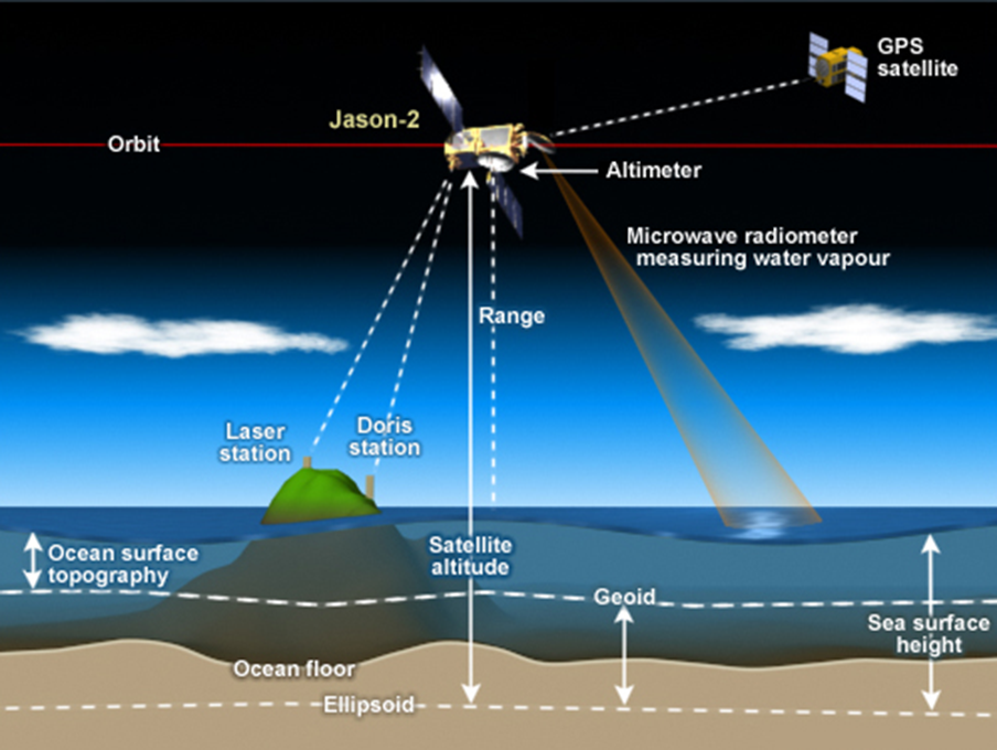
IEEE microwave radiation wavelengths are from 2.7mm up to 1.5 meters. NATO radar bands start at 3 mm up to 1.2 meters.
Without definitive satellite positioning, the minimum possible error is 5.4 mm.
Then the programmers get into action of the data collected:
I’m not a fan of believing that erroneous sums, calculated thousands of times gives a “best guess” number that gets published. Every datum in the sea level database should be recognized as having a large range of possible error.
Rode a train into work daily for over ten years. That train passed along the Potomac River for much of the ride.
One windy days, the waters of the Potomac and inlets either rose substantially or declined substantially.
Wind moves water! Days of wind move water as far as that wind reaches. Wind towards shore raises the water height substantially. Wind blowing out to sea lowers the coastal sea level.
A truly excellent article, Andy! Kudos to Alan Welch!