Guest “Letterman shtick” by David Middleton
Who else remembers way back when David Letterman was funny? Two skits really stood out:
Eric Berger provided his version of Stupid Meteorologist Tricks in this ARS Technica article:
GO AWAY, LAURA —
There’s a big hurricane headed toward Texas, and it’s a nightmare forecast
As a meteorologist, all I can think is “here we go again.”
ERIC BERGER – 8/25/2020It seems increasingly likely that Hurricane Laura will continue to intensify on Tuesday and Wednesday before making landfall along the upper Texas coast, or possibly southwestern Louisiana, early on Thursday.
Of all the many named storms in 2020—and we are on the “L” storm already with the early September peak of the Atlantic hurricane season still looming—this one has the potential to wreak the most widespread devastation yet. This is because Laura will likely become a major hurricane before landfall, reaching Category 3 status, and could potentially strike the populous Houston metro area.
That happens to be where I live, in a home about 15 miles from the coast. And as a meteorologist, all I can think is here we go again. Just three years ago to this very date, Hurricane Harvey brought record flooding to the Houston community and its surrounding areas. It became the worst flood storm in US history.
[…]
Which brings us back to Houston. Right now, the metro area lies on the extreme western edge of the National Hurricane Center’s forecast cone. The storm is predicted to make landfall about 90 miles to the east of Houston. This is far enough away from the storm’s center to spare a metro area with a population of 7 million people from the worst. In fact, much of the city would not even see tropical storm-force winds.
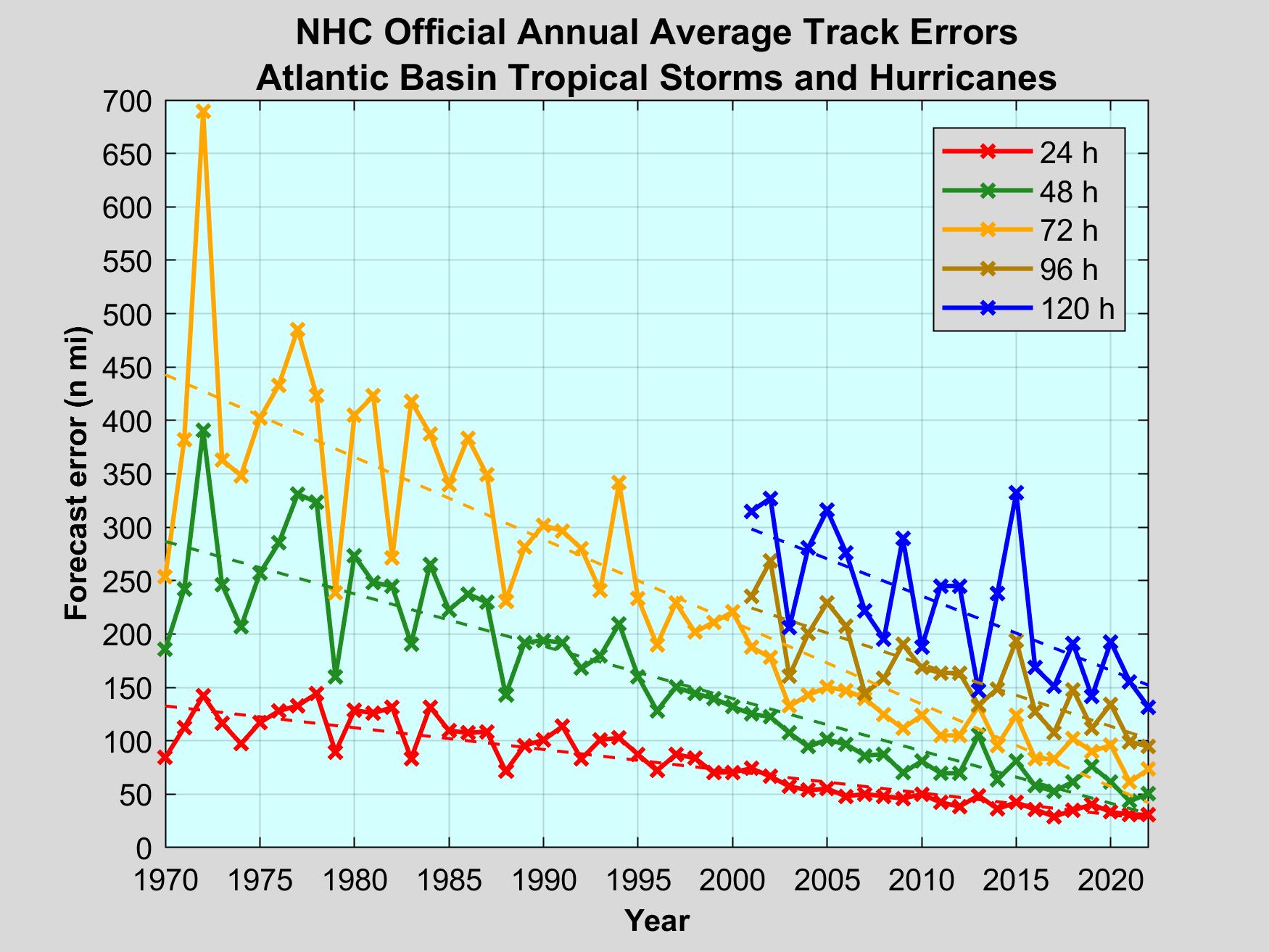
But if the storm were to come in 90 miles to the west, along Galveston Island, it would be an entirely different story. And this is entirely within the realm of possibility, given the average forecast track error of about 75 miles at this time and the fact that some hurricane models still indicate this scenario.
[…]
ERIC BERGER is the senior space editor at Ars Technica, covering everything from astronomy to private space to NASA. A certified meteorologist, Eric lives in Houston.
ARS Technica
How many Stupid Meteorologist Tricks can you spot?
Let’s start with the headline: “There’s a big hurricane headed toward Texas, and it’s a nightmare forecast.” Firstly, “Texas” is a big target. Stating that hurricane is “headed toward Texas” is like saying it’s in the Gulf of Mexico. “And it’s a nightmare forecast”… Not for Houston. The forecast is that it will make landfall just east of the Texas-Louisiana border. This forecast hasn’t changed much in several days.

This is a very destructive storm. The storm surge threat is extreme, particularly on the northeast side of the storm (farthest from Houson).

NOAA describes the potential storm surge as “unsurvivable,” just not in Houston.

I topped off the tanks of both of our vehicles today, and plan to keep them topped off, because there is some potential for significant refinery and distribution disruptions.
“But if the storm were to come in 90 miles to the west, along Galveston Island, it would be an entirely different story”… If the storm was a 6-mile wide chunk of rock falling from space, it would also “be an entirely different story.” While it may not be impossible for Laura to suddenly veer left into Houston, it’s not the forecast.
Mr. Berger did get one thing right: “Here we go again,” with more climate catastrophe porn from Alarmists Reject Science Technica.
Several geologist friends of mine said 30 years ago that Houston had subsided by 2 ft owing to water extraction. 2ft , probably more now, would seriously increase the likelihood of flooding.
4 Eyes,
Maybe they should emulate the Dutch and abandon any land areas near to or below sea level! Oh, wait! Never mind!
The Dutch coast isn’t usually hit by category 4 hurricanes…
Hurricane category does not influence flooding risk.
We do occasionally get a hurricane with winds over 120 kph.
I live near the lowest point in The Netherlands, 7 meters (app.23 ft) below the sealevel.
No problem even with a hurricane now and then.
https://en.wikipedia.org/wiki/North_Sea_flood_of_1953
Flood risk in Houston is decreasing, not increasing.
Subsidence in Houston was driven by extensive groundwater extraction, but that was halted decades ago. The city’s water system is now sourced exclusively from surface water.
Flood control projects in Houston are taken very seriously. In my area, a project on Brays Bayou is widening the channel, raising bridges, and adding detention basins. It’s expected to be complete next year and forecast to lower the 100-year flood elevation by about 2 feet. That will reduce flooding risk for tens of thousands of homes.
4 days ago the Alarmist Rejectors of Science were literally peeing themselves in their giddiness over the possibility of two hurricanes simultaneously in the Gulf. When that hoped-for Happy Ending narrative flopped, they had to move on to another climate porn narrative for their titillations and perverse pleasures.
All they’ve got now is the “number of named storms” schtick to beat their drum with. But look at a TS Marco, a big nothing storm, that never made any landfall resembling anything like a tropical storm, but served its purpose of taking up another name off the seasonal list.
But it appears Laura will move with enough speed across the SE US towards a DC coast out exit that its substantial moisture will be wildly spread across its track. Remember how just 3 years ago, stalled hurricanes dumping torrential rains in the same spot were supposed to be the “new normal”? Basically the alarmist tropical meteorology community will just makeup whatever story fits an alarmist narrative and hope people don’t remember previous year’s narratives it contradicts.
widely, not wildly. Sigh.
Joel,
Shouldn’t they be the “Alarmist Suppressors of Science?” After all, they embrace any shred of Science they find that corroborates their religious dogma and the acronym is so apt!
Joel,
Correction. They should be Alarmist Rejectors of Science and Evidence! I should know better than to try and write something when I wake in the middle of the night!
A.R.S.E. Technica is a great name for a group that specializes in climate catastrophe porn!
And then, if they were based out of Woods Hole…
Never let a good weather event pass without claiming it is the new normal.
As a meteorologist, all I can think is “here we go again.”
possibly
could
likely
has the potential
if
models still indicate this scenario
Eric is clearly a bit of a berger
A nothing-berger.
I hope it doesn’t hit Oregon.
Oregon is just one big volcano-lava flow, with pretty green forests and scenery that hides what’s just below the surface. Nature has other plans for Oregonians.
Is it just me but the forecast is for 130mph sustained winds but the highest observed appears to be 85mph gusts.
What am I getting wrong?
What am I getting wrong?
You’re not using a computer model
One gust of 132 on the ground, NE eye wall in an article reposted at Zero hedge.
I looked at buoy data near the track and eyeballed the wind data ramp up/down. Basically sustained 45 knots gusts to 65. Haven’t seen any data on the storm surge yet.
“forecast is for 130mph sustained winds”
Most of the online resources are showing wind speeds which are just forecasts, not instrument measured, which tend to overestimate speeds. That is probably deliberate, to alert “worst case scenario” etc.
If you want to see a map of _actual_ instrument records around Lake Charles now, try using the MesoWest online network, operated by the Univ of Utah: https://mesowest.utah.edu/
It is little tricky to use, but provides real-time access to thousands of U.S. government and personal weather stations (CAVEAT: of varying quality and reliability).
When the map comes up, click on Lousiana. Then in “Data Selection” on the left, make sure Region=Lousiana and then set Network: to “All Networks”. Then in “Display” select “Wind Gust”. Then zoom into the area around Lake Charles, and you will see many weather stations. In particular you should see two stations south of the city near the ocean Calcasieu Pass (“CAPL1”) and LaCassine (“LACL1”), appear to have reliable instruments, which recorded Laura as she made landfall.
Click on the black dot of each station to see a time plot of temperature, wind, rain etc.
It is all real data! Some of the stations may be broken (usually colored orange or red), so look at many stations to form your own estimate of weather conditions.
If you make a selection and nothing happens, then that means you did not press the red button labeled “Refresh Map”! (I warned you it was tricky)
For those who cannot get it work, Calcasieu (which is located right on the ocean edge) was not able to measure the peak winds, but recorded gusts near 130 and sustained above 90 before it jammed. LaCassine, a few miles inland, recorded peak gust around 95 and sustained above 60.
Here are links to download their data in Excel (csv) format:
https://mesowest.utah.edu/cgi-bin/droman/download_api2.cgi?stn=LACL1&hour1=11&min1=07&timetype=GMT&unit=0&graph=0
https://mesowest.utah.edu/cgi-bin/droman/download_api2.cgi?stn=CAPL1&hour1=11&min1=07&timetype=LOCAL&unit=0&graph=0
LACL1
CAPL1
So the official landfall site of Laura was Cameron, La. Which also happens to be the location of the Calcasieu Pass weather station, so download the CAPL1 link above to get the weather history for that event.
It did not record the peak sustained wind, but eyeballing the wind plot just before the peak, I estimate it was greater than Cat1 max 95mph, but probably not greater than 110mph, so it was a Cat2 landfall. IMHO. But the media are claiming it made landfall as Cat4.
Who is holding the official thermometer?
I believe NOAA was claiming 130mph sustained wind speeds after landfall…
More of their satellite air pressure estimates fed into their wind speed model…
All performed by the same technology that allows NOAA to declare transitory storms as official tropical storms or hurricanes. That historically would never have made official lists before NOAA declared their current technology as meteorological science.
You do not understand the wind distribution of a hurricane.
The maximum sustained winds are usually in a small portion of the NE eye wall. Those winds drop off rather quickly away from the eye wall. Too many people look at the pictures of a hurricane and falsely assume that those maximum winds are occurring under the entire cloud cover.
“The maximum sustained winds are usually in a small portion of the NE eye wall”
At flight altitude. Wind speeds at ground level are a different story. However, the NHC and others continue to use flight level measurements (and inaccurate “extrapolation”) for hurricane categorization that defy the requirements set forth in the Saffir-Simpson scale. Thus we end up with actual ground level measurements that don’t line up with what’s being reported.
The Saffir-Simpson scale is used to estimate potential property damage due to winds. It is why there is a wide range at each category level.
The extrapolation method is what it is. Barometric pressures have known winds associated with them that have been well documented over time. Just because a buoy or weather station measures less wind speeds does not mean those wind speeds do not exist. It just means it does not exist at that point on the map.
Yet quite often lately storm surge and damage do not correlate with reported wind speed, and I have not read how accurate barometric pressure is for ground speed winds.
But 8nbany case we now record maximum modeled and real time winds verses disparate direct measurements from the past that were progressively less capable of recording peak strength the further back in time one goes.
Doesn’t that assume that barometric pressures, and their differentials which create the winds, are stable over a one-minute period to produce stable winds for that length of time? I would think pressures are varying as rapidly as the wind. Do they require a sustained pressure differential over a one-minute period, or do they rely on instantaneous measurements?
The crazy thing about the Saffir-Simpson scale is that it was developed “backwards”. They observed the damage, then determined what the wind speed was that had caused it.
Now however, NOAA etc. find the spot with the very highest wind speed, measured to extreme accuracy, or maybe not even measured, but extrapolated, then use that wind speed to categorize the hurricane. The property damage resulting usually no longer corresponds to the the Saffir-Simpson category.
The original intention if the S-S scale was so Dr. Simpson could communicate to disaster relief agencies how much damage to prepare for. It wasn’t intended for public use. But news media found it a convenient way to convey the potential harm to the public. It’s only pegged to the maximum sustained winds, which occur only in a small area if the radius of max winds. This says nothing about the extent of the storm nor the storm surge. There have attempts to come up with better metrics, such as IKE, to convey info but NHC has Ben slow to change. At least know storm surge forecasts are given independent of S-S scale forecasts.
Yes Tom, yet this makes historical comparisons very difficult.
Biggest reported storm surge so far is 9.4 feet.
Yes, a very serious hurricane but we will see if there is cat 4 damage where the NE eye wall came to shore.
Lately measured storm surge and observable damage is typically greatly reduced compared to the real time modeled wind speeds and storm surge estimates.
Maybe they need to go back to the drawing board and re-define the Saffir-Simpson index from first principals. I suspect that if they did this, they would find that for the damage levels of the Saffir-Simpson index, the wind levels would be quite a bit higher.
Tin who are you replying to. From my perspective it looks like you are assuming ignorance.
Lake Charles is a little ways inland and between 1:30 AM to 2 AM C.D.T it was reporting sustained winds of 98 M.P.H with gusts at 128 M.P.H.
At this point the wind reports stopped but was still reporting temp of 77 F and 957 millibars of pressure.
My understanding is that they are talking about wind speeds at 10 meters.
Are any of the buoys that tall?
Lake Charles is a city of 70,000 people. I pray that they evacuated. Most of that area is wildlife preserves and parks
Weather porn is real. Last week we had storms and the local media went crazy. They get big ratings. Makes sense.
One station put a reporter in a car with a camera and presumably told him to find death and destruction. The poor guy could not find much. My favorite porn scene was when he pulled over in heavy rain and with his windshield wipers squeaking the studio guy said “now this is a lesson to all you people to pull over if it gets bad and please keep both hands on the wheel because of localized flooding.”
David,
Rats, I won’t be going to town for supplies until next week so I’ll probably have to pay an inflated price for fuel at that time! Thank you for the update on Hurricane Laura!
I just got into a little spat with my sister Laura because she doesn’t believe HCQ might be effective. But she gets all her info from people like Eric Berger in the Fake News! Seems to cause brain rot if taken in large doses!
I hope the storm weakens and moves rapidly inland so that you don’t have to do much more than laugh at the inane and plot further skewerings for them!
I’m thinking they should be Alarmist Suppressors of Science of the Earth and Seas! Too long, huh? Stay safe and dry!
If you are in the projected cone of a rapidly-intensifying hurricane get out of the way! I was in an air traffic control tower in DiAn, Vietnam, in 1969 when a hurricane (typhoon?) was projected near us, but not over ur. We therefore had many refugee aircraft, exceeding the tie-down capacity. The tower was about 60 feet high, open beam construction, with an enclosed cab on top, and had a wind-gauge on top. The engineers that constructed it placed a placard inside that said “Abandon tower at indicated wind speeds above 90 knots). The hurricane came directly to us, and myself and a young guy watched the wind speed gust upward to 90 knots (103 mph), roofs coming off, aircraft cartwheeling away, rain like standing in the shower, etc. I ordered the younger controller to abandon the tower and issued a closing operations call and started shutting down. Back into the cab comes the controller and says you can’t get down the winds are too strong, and he was right, you would be holding onto a hand-rail and flapping in the wind if you tried. The wind steadied and climbed to 111 knots (128 mph) where it stayed steady (in the eye wall, but never the eye itself). I got on the down-wind side and put my flak jacket over my head, expecting to feel the tower go over. The howling and shrieking of the wind was like a horror movie. Then it started slowing down and around 80 knots we could see the ground again. We were now in a tower in a lake! The roof stayed on our hootch, probably because it was open for ventilation, but the destruction from wind and flooding was incredible. Get out of the projected cone of any intensifying hurricane. Wait a minute…surf’s up! Cowabunga, dude!
Funny story… In 1977, two colleagues flew to Brownsville to record radar data from the NWS radar of Hurricane Anita as it passes to the south. They were on the last airplane flight into Brownsville. When they went to baggage claim to get their recording machine, everyone else in the flight were claiming their surfboards! Eddie would go.
I got a taste of that typhoon, too, Ron. We were deployed beside a small creek at the time that turned into a roaring river in a very short period of time, and forced us to move to higher ground. You could see that creek getting visibly higher and higher like watching a bathtub fill up.
I think they said we got 22 inches of rain in that 24-hour period. I don’t remember the name of the typhoon.
Hard to imagine being “deployed” during the typhoon, it was difficult enough with your hootch in sight. We got almost a meter of rain in about 12 hours, and the erosion was strong enough to reveal an old (French, WWII?) minefield where we commonly played football. Stay sane and safe.
Pure click bait. Laura is topical and will likely be a big story. The more page views, the model more web ads to sell.
Off topic- but I wanted to mention this.
The latest bullshit from Willy McKibben; https://www.newyorker.com/news/annals-of-a-warming-planet/on-climate-change-weve-run-out-of-presidential-terms-to-waste
After reading this climate porn from McKibben, I realized that your description of it was far too kind.
ARSE Technica..
We all know where they pull their “technica” from!!
The failing, anti-science NYT’s is now bloviating about “The growing power of hurricanes”. So predictable, and so wrong. Amazing how quick they are to jump on any disaster, or potential one, to push the narrative. How very Alinsky of them.
Any TC in the Gulf this time of year has the potential to become a “powerful hurricane”. It’s just the nature of things.
https://www.bbc.co.uk/news/world-us-canada-53928960 The BBC take.
A single storm, no matter its extent, wind speed, total cyclone energy, rainfall, or storm surge, has no interpretation in terms of AGW climate change because of its time and geography constraints. Under these conditions, internal climate variability dominates making it impossible to find an AGW signal in the data. Please see
https://tambonthongchai.com/2020/07/16/the-internal-variability-issue/
As for an AGW impact on intensity, wetness, and destructiveness of tropical cyclones in the AGW era, the science says that this signal can be found in long term trends longer than 30 years for the total Accumulated Cyclone Energy of all tropical cyclones in all six tropical cyclone basins.
The bottom line is that a single storm has no such interpretation. Not even a single basin does. You need all six basins and data for more than 30 years. Pls see
https://tambonthongchai.com/2020/03/04/agwcyclones/
https://tambonthongchai.com/2019/11/14/hurricane-obsession/
We survived unscathed by Hurricane Huge in Mount Pleasant, SC, across the ICW from Sullivan’s Island and a bit south of McClellanville. I know just how fortunate we were, but also the hype of the doom saying prognosticators without doxastic comittment. Skin-in-the-game heightens ones awareness greatly.
I’ll watch the weather maps and make my own judgements.
Corollary of Middleton’s Law -“Exaggeration means”Fxxk it, it’s not happening! “
That’s just the natural response to exaggeration. See: The Little Boy Who Cried Wolf.
The wolf at the door sounds like it’s crying.
Constipated.
Did anyone survive?
Last year — “Global warming is making hurricanes slow down, which means global warming is causing more flooding!”
Okay, but this one isn’t moving slow, how do you explain that?
“Global warming is making hurricanes stronger!”
Okay, how do you explain the 1935 Labor Day hurricane that went from tropical depression to one of the strongest tropical cyclones ever in all of recorded history for the entire planet in just 30 hours?
“Global warming is causing more tropical cyclones! How else do you explain so many names being used so early?”
Okay, then why was Barack Obama the only US president in recorded hurricane history to never have a major hurricane make landfall during his tenure?
Don’t you know he “healed the planet?”
This moron has been hyping hurricanes and climate change for the last 15 or so years. Nothing new here…he’s just trying to generate come revenue clicks. I’m just disappointed I can’t read his rubbish less often than never.
But … I woke up this morning to news of Cat 2 and a 9-foot surge. Sturm und Drang.
“Likely become a category 3”, and I’m reading that it “could be the most powerful storm to ever hit Louisana”
Wasn’t Katrina a Cat 4 when it hit? Wasn’t Camille (1969) Cat 5? But “It’s worse this time” I guess?
There is something worse, but I think it’s not the storm.
Katrina was a Cat 3 when it made landfall.
There are a lot of downed trees, power lines, roofs blown off, flooding around bayous, broken windows and debris scattered about but it could have been much worse. There are no reports of casualties yet at least according to this station.
https://kfdm.com/news/local/video-homes-destroyed-flooded-by-hurricane-laura-in-lake-charles
One14 YO girls was killed by a tree falling on her house.
Report: Hurricane Laura is unexpectedly “Mostly Peaceful”
I note what you did there.
Damage photos are being posted out of Lake Charles, plate glass installers are going to be busy for the next year.
Bit of a let down for them wolfie lad….
Looks like everyone survived the unsurvivable …. obviously it doesn’t mean what we assume it means, like everything else to do with the ”climate crisis” and the dooms day molecule.
Eric is an excellent meteorologist who frequently demonstrates common sense in his blog on Gulf coast weather. Because of that he has a large following.
He is, however, a hard core ‘science is settled’ kind of guy and is quick to quash any alternate interpretations of weather and climate. Caveat emptor.
Did they start using the wind gusts instead of the max. speed to categorize storms? It seemed for these storms that they upgraded them to Category 1, 2, etc. based on the gusts when if they used the max. speed they would have stayed in a lower category longer.
I have to agree with Tony. Damage not consistent with cat 4. I think we’ll be seeing more like this.
https://twitter.com/Tony__Heller/status/1298999182535962624
I know Eric very well He is an honest guy and is simply stating what he is observing, There is no evidence in what he is saying reveals any bias no more than the fact that I was extremely worried about that option of it shifting west given the Euro with its strong west ensemble blend. Am I an alarmist now too, in spite of the fact that we identified over 10 days out and in the preseason why this was precisely the kind of storm that would do this ( hint MJO) you know there are some people you may disagree with on the issue of climate change and I do , that are pure of heart. I know that may be hard to believe, but sometimes, and I speak from experience, I think things about others that I know in me. Eric has always been an honest broker, And another thing, as someone who has a 40 year history of “competing” with the hurricane center they are too, It does no one any good to hype something that does not happen. Dont lump them all in with the cottage industry agenda driven crowd.There are good people on that side, and the guy was just trying to point out the inherent worries ( and was mine, cause unlike the monsters like Rita and Ike, I knew people would not pay attention until it was too late) and dont have an agenda. Yes that is rare I admit that. No I am not selling out, I am telling the truth as I know it about someone I have known for 20 years and is darn good at what he does
I appreciate you sticking up for your friend and vouching for him. What really gets on my nerves is the constant hyperbole coming from climate-type writers. I know nothing about this guy, can’t remember reading anything he’s written, but immediately took issue with his overstating things, like nightmare forecast and potential to wreak the most widespread devastation yet and worst flood storm in US history. Yeah we get it; just shut the hell up with the speculative hyperbole; we’re always hearing stuff like that and it’s getting really, really old. He didn’t bother to substantiate his worst US flood storm ever claim in the article he authored and linked to. I would bet the Flood of Harvey pales in comparison to the Great Flood of 1862.
“Climate Tricks” can also be referred to as “Climate Porn”
Dennis,
Wouldn’t “Climate Tricks” be performed in a private setting, while “Climate Porn” is recorded on video, stills or the written page?
Looking at videos of damage we see mainly CAT 2 damage, perhaps some weak CAT 3. I don’t know exactly where the NE eye wall went through or if we have those photos.
Category Two Hurricane
Winds 96-110 mph (83-95 kt or 154-177 km/hr). Extremely dangerous winds will cause extensive damage: Well-constructed frame homes could sustain major roof and siding damage. Many shallowly rooted trees will be snapped or uprooted and block numerous roads. Near-total power loss is expected with outages that could last from several days to weeks. Frances of 2004 was a Category Two when it hit just north of Palm Beach County, along with at least 10 other hurricanes which have struck South Florida since 1894. Storm surge of 6 to 9 feet.
Category Three Hurricane
Winds 111-129 mph (96-112 kt or 178-208 km/hr). Devastating damage will occur: Well-built framed homes may incur major damage or removal of roof decking and gable ends. Many trees will be snapped or uprooted, blocking numerous roads. Electricity and water will be unavailable for several days to weeks after the storm passes. Unnamed hurricanes of 1909, 1910, 1929, 1933, 1945, and 1949 were all Category 3 storms when they struck South Florida, as were King of 1950, Betsy of 1965, Jeanne of 2004, and Irma of 2017. Storm surge of 9 to 12 feet.
Category Four Hurricane
Winds 130-156 mph (113-136 kt or 209-251 km/hr). Catastrophic damage will occur: Well-built framed homes can sustain severe damage with loss of most of the roof structure and/or some exterior walls. Most trees will be snapped or uprooted and power poles downed. Fallen trees and power poles will isolate residential areas. Power outages will last weeks to possibly months. Most of the area will be uninhabitable for weeks or months. The 1888, 1900, 1919, 1926 Great Miami, 1928 Lake Okeechobee/Palm Beach, 1947, Donna of 1960 made landfall in South Florida as Category Four hurricanes. Storm surge if 18 feet plus.
You drastically messed up on this opinion, Middleton. The headline is true. A few days out, it was headed directly toward the Texas Coast. Your comment about the size of Texas is irrelevant–obviously, he was not meaning West Texas. Is not the upper Texas coast not part of Texas? His comments on the variability of forecast landfall is spot-on. If Marco was not a good enough example for you, look at the history of forecast landfalls for Rita and just about every other hurricane that lands in Texas or Louisiana. All the ifs are being objective, not hyping the forecast. Here in Houston we know all too well what a few miles difference in landfall can mean, and your snide comments don’t change that. Berger is an excellent unbiased meteorologist who tries to clearly lay out the possibilities.
Native Houstonian here, been through a LOT of storms & hurricanes. One neighbor posted about the ‘unsurvivable’ storm surge that would come with Laura. Our local news flacks began the panic talk early. I had seen some weeks ago a piece conflating the pandemic and an active hurricane season so panic early, panic often.
We had a ‘cool’ front arrive before either Marco or Laura so I didn’t see how storms can come in against a head wind like that, and what do you know, they did not.
I remember one storm many years ago where I went to sleep thinking it would strike west of Houston. then the power went out and later in the night the eye passed over where I lived so that forecast lost out to the storm taking its own direction. So it goes.