Reposted from Dr. Roy Spencer’s Blog
August 26th, 2020 by Roy W. Spencer, Ph. D.
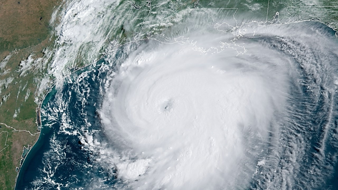
As I write this, it looks like major Hurricane Laura will arrive on the Louisiana coast late tonight as a Category 4 hurricane somewhere south of Lake Charles.

There will be the inevitable fake news coverage claiming how U.S. landfalling hurricanes are getting worse, a subject which I addressed in my Amazon Kindle e-book Inevitable Disaster: Why Hurricanes Can’t Be Blamed on Global Warming.
Of course, hurricane damage has increased, as people flock to the nation’s coasts and associated infrastructure increases. But we should remember that (for example) Miami only had 444 residents when incorporated in 1896, and now the Miami metroplex has over 6,000,000 inhabitants.
So, yes, storm damage will increase, but not because the weather has gotten worse.
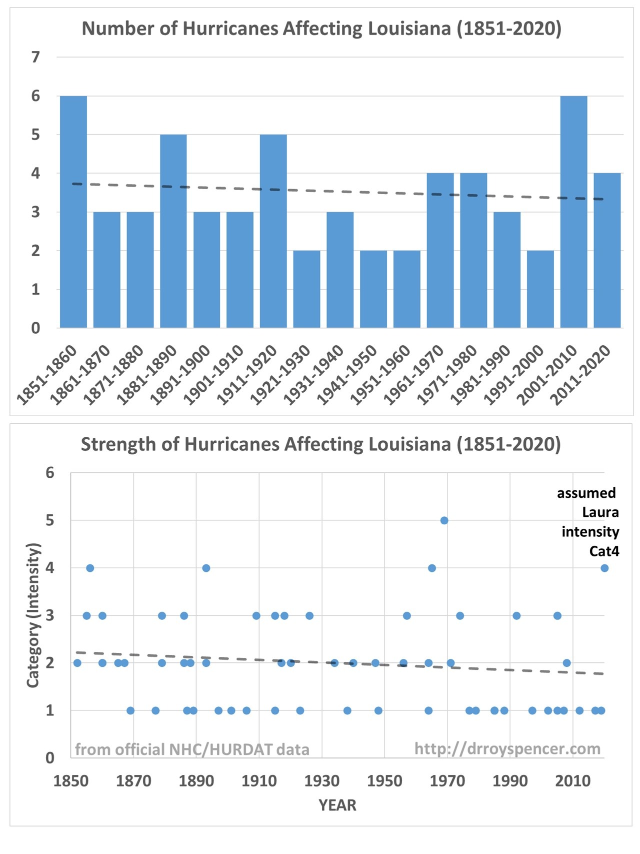
Given the current event, which is sure to bring major damage to southwest Louisiana, I thought I would present the statistics for all documented hurricanes affecting Louisiana in the last 170 years (1851-2020).
Neither Hurricane Numbers nor Intensities Have Increased in Louisiana
If we examine all of the hurricanes affecting Louisiana in the last 170 years in the National Hurricane Center’s HURDAT database (as summarized on Wikipedia) we find that there has been no long-term increase in either the number of hurricanes or their intensity since 1851.

Again, this is based upon official NOAA National Hurricane Center (NHC) statistics.
https://kachelmannwetter.com/de/sat/2a2583c758795cb5da8c7d0c137f4503/satellit-superhd-1min/20200826-202525z.html#play-0-94-5
Right now, it looks like Laura will make landfall as a Cat 4 between Beaumont TX and Lake Charles LA and plow through the heart of refinery country. While it’s not expected to cause nearly as much disruption as Harvey, gasoline might get scarce next week. Refineries are the brown rectangles,surrounding white oil drums:
https://www.eia.gov/special/disruptions/
I believe you are correct, David. In the past day here in Va. Beach, gasoline prices have risen over $.10/gallon.
Gasoline would get scarce if refinery output and distribution were significantly disrupted by the storm… None of which has actually happened yet.
Gas prices are generally rising because demand is recovering. https://www.eia.gov/petroleum/weekly/gasoline.php
I imagine that most of the refineries in line will have shut down anyway, so there will be less supply for a while. Plant will not be restarted until it is shown to be safe and undamaged. Pipelines, including the feed to the Colonial that heads NW are unlikely to get damaged. Tankage is more at risk when empty, though Exxon Baytown suffered water ingress via a floating roof in the heavy rains of Harvey. Pipetracks and column plant at clear risk of damage.
Thanks you David
Thanks for that David
Everything is REALLY bad, and it’s gettin’ WORSE. That’s my story and I’m stickin’ to it!
(Signed) Eco Freakus
Facts are for saps.
A weatherman on CBS says the Atlantic is boiling because of climate change and that this is why Laura will be the worst ever to his Louisiana.
I see that some media (at least here in Australia) have classified it as unsurvivable
The storm surge is only unsurvivable if one stands there and let’s it wash over them.
Most people have enough sense to move out of the way. I think that’s the case with Hurricane Laura. I haven’t heard of anyone who has lost their life yet, and none who were inundated by the storm surge.
So calling it “unsurvivable” is hyperbole and stating the obvious. Any storm surge is unsurvivable if you get caught up in it.
The unsurvivable language for storm surge areas is taken straight from the national hurricane centre’s forecast discussion, accessed August 27 8am ontario canada.
https://www.nhc.noaa.gov/text/refresh/MIATCDAT3+shtml/270842.shtml?
Key Messages:
1. Unsurvivable storm surge with large and destructive waves will
cause catastrophic damage from Sea Rim State Park, Texas, to
Intracoastal City, Louisiana, including Calcasieu and Sabine Lakes.
This surge could penetrate up to 40 miles inland from the immediate
coastline, and flood waters will not fully recede for several days
after the storm.
https://twitter.com/NHC_Atlantic
Brst wishes to all living there around !
At least Laura is moving along and there is nothing to slow it down like what happened to hurricane Harvey. Harvey slowed down and dumped tons of rain on Texas. Laura won’t do that.
Yep, Harvey hovered.
They blamed that on CAGW as well.
Alarmists blame everything on CAGW (Catastrophic Anthropogenic Global Warming).
They see what they want to see.
They still haven’t provided any evidence for the existence of CAGW in the real world. But they keep claiming they can see it. Delusional, is what they are.
A global view
https://tambonthongchai.com/2019/08/01/tropical-cyclones-climate-change/
Also this
https://tambonthongchai.com/2020/03/04/agwcyclones/
Good luck to all in the Houston area and Galveston/Beaumont stretch of the Gulf Coast and the folks in Louisiana. Hope it weakens a bit before making landfall……
I use Windy dot com to show wind speeds, and consistently see speeds much lower than NHC reports.
Just prior to landfall, NHC showed 155 kt wind, and Windy showed 115 kt.
At 4am, well after landfall, NHC showed the storm was still a hurricane, Windy showed a maximum of 57kt, which makes it a tropical storm.
What gives?
Well they’re not lying. But I am.
See this all the time now. I think it best to look for time and location of highest ground speed Reading if it is in the NE eye wall, otherwise and or check for the actual storm surge, as that is modeled from the predicted wind speeds. Suite often lately the surge has been considerably less then predicted.
Aren’t hurricanes powerful heat pumps that scour astounding amounts of heat out of the water and atmosphere and either eject it outerspace or carry it to northern latitudes where it dissipates… to outerspace? (I believe I have seen charts on this site, showing the relatively cool waters left behind after one of these behemoths sweeps through)
I believe Willis has described that on this site, but I just want to be sure I understood correctly.
In the hourly dispatches the National Hurricane Center posts in advance of Laura it lists actual wind speed measurements. They all show sustained winds about 100 or less. National Weather Service Lake Charles recorded E 98.
Capli1 the nearby buoy on the NDCB showed max 81 at midnight.
News reports keep citing 150mph winds. “Category 4 that quickly degraded after landfall”
I set my oven to 375, but the chicken on the counter is still raw.
NDBC Station CAPL1 recorded sustained winds. Storm passed directly over this station at maximum intensity. Most sustained winds were in the 60 to 70 knot range.
Saved photo of the combined time plot of winds and pressure.
https://photos.google.com/photo/AF1QipM7hHPu44Alv8c8VxwA2FVebjFFU1UdbJhFvRWm
Note that the aemometer height is 12.3 meters above site elevation which is sea level.
NDBC station TXTP2 shows similar data.
earth nullschool winds were monitored in real time, with similar wind speeds.
Damage photos confirm Saffir-Simpson categorry 1 wind damage.
Certainly not a major hurricane.
And that’s the confusing bit, the same NHC alerts also describe/predict 150mph winds. So in some way the media has cause to believe they aren’t misinforming.
Not accurately providing other real time observations is more about lazy or non-contextual reporting than dishonesty.
Perhaps these are at higher altitude measurements, or inferred from modeling, what have you, but is this always the way storms are categorized? Does post event analysis change the labeling of storm ferocity?
But rather sad all around, one side wanting desperately for it to be “unsurvivable” “catastrophic” to prove a narrative, and another side saying “come on it wasn’t really bad” to feed the other narrative, neither side really concerned with folks’ lives upended, stuck the resultant mess.
Highest reported measured gust seems to be 132mph at Lake Charles. Sustained winds were 115mph in Cameron County – landfall. Cat 3 looks a more accurate categorisation.
No sign of extensive refinery damage as yet. It seems that high stock and reduced demand means that runs have been only around 80%, allowing other plants to pick up the slack, so shortage will be about distribution bottlenecks more than anything else. No major flooding to contend with either it seems.
Are those speeds knots or mph? I’m guessing knots.
If so, these measurements agree completely with my live checks of Windy dot com.
Why is the NWS/NHC overstating wind speeds?
To ask a question is to answer it.
So, the hurricane was briefly a Cat3, and dropped from Cat2 to Cat1 to Tropical Storm within 20 miles of landfall. These guys are LYING!
We basically have about 150 years of recorded storm probabilities and intensities along the gulf coast. I don’t know how any conclusion can be made about “global warming” influence on this. This morning I ran into a link to an article discussing a method for assessing the probability of high intensity storm along the gulf coast. Interesting research activity. Also a new word for the day: “paleotempestology”. A lot of questions need to be answered but it appears that some information about historical category 4 and 5 storms can be gleaned from the samples they are analyzing. Interesting in any event.
https://www.americanscientist.org/article/uncovering-prehistoric-hurricane-activity#
Looking at the damage photos and video in Lake Charles (30 miles inland) and using the Fujita tornado damage scale, they received the equivalent of an F2 tornado (113–157 mph) throughout the city. I’m still watching for the first photos and footage from Cameron and nearby coastal developments.
One local TV meteorologist and crew spent the night with live feed from their cars in downtown Lake Charles. I watched as the eyewall approached, engulfed them, and then when they were inside the eye. Sustained winds, with gusts and meso-vortices from multiple directions made for a lot of damage. There are few windows left in downtown high rise buildings
The photos I saw did not show anything like cat 4 damage.
Damage photos and real time media video show Category 1 winds for Laura
Confirmed by two NDBC surface anemometers, CAPL1 and TXTP2. Data was logged, anyone can see the data from those two stations.
Monitored earth nullschool winds in real time. Winds were consistently in the Cat 1 range.
Laura was certainly not a major hurricane.
US has a problem.
Overestimating.
Laura came in as a reported 4 graded hurricane but did only meet the devastation for a 1 graded:
https://www.nhc.noaa.gov/aboutsshws.php