Stockholm University

34 million years ago the warm ‘greenhouse climate’ of the dinosaur age ended and the colder ‘icehouse climate’ of today commenced. Antarctica glaciated first and geological data imply that the Atlantic meridional overturning circulation, the global ocean conveyor belt of heat and nutrients that today helps keep Europe warm, also started at this time. Why exactly, has remained a mystery.
“We have found a new trigger to explain the start-up of the Atlantic current system during the greenhouse-icehouse climate transition: During the warm climate, buoyant fresh water flooded out of the Arctic and prevented the ocean-sinking that helps power the conveyor. We found that the Arctic-Atlantic gateway closed due to tectonic forces, causing a dramatic increase in North Atlantic salinity. This caused warming of the North Atlantic and Europe, and kickstarted the modern circulation that keeps Europe warm today,” says David Hutchinson, researcher at the Department of Geological Sciences, Stockholm University, and lead author of the article published in Nature Communications.
The team of scientists, from the Bolin Centre for Climate Research, used a combination of geophysical data and climate modelling to show that the freshwater transport through the Arctic-Atlantic gateway plays a critical role in controlling the overturning circulation.
“Not only did deep water start forming in the Atlantic Ocean, it also stopped forming in the North Pacific at the same time, which matches geological evidence. We were surprised to find that our computer simulations can explain both of these changes due to salty ocean currents connecting the Pacific to the Atlantic. Our study is the first to show that these two events are linked, which is very exciting,” says Hutchinson.
The climate at this time was very warm, with atmospheric CO2 levels two to three times the present day levels, and this contributed to extremely fresh Arctic waters. The study begs the question of whether in a future warm world, in which the Arctic may again be very fresh, the sinking in the Atlantic may cease again, which may dramatically alter the climate of Europe. Without the Atlantic conveyor belt, Europe can experience both colder winters and hotter and drier summers, making a more extreme and inhospitable climate.
“Our study helps to bridge the gap between climate modelling and geological observations of the deep past. We hope this will inspire further research from both communities on the deep circulation of the ocean,” says Hutchinson.
###
More information
The article “Arctic closure as a trigger for Atlantic overturning at the Eocene-Oligocene Transition” is published in the scientific journal Nature Communications: http://dx.doi.org/10.1038/s41467-019-11828-z
“The climate at this time was very warm, with atmospheric CO2 levels two to three times the present-day levels”… The Climate Alarmists and Global Warmistas will not like to read that and will have to get their control systems activated to have the article suppressed or banned.
It’s junk anyway. Any paper claiming that the ‘conveyor’ will stop is clueless. That erronous idea is based on the hypothesis that the thermo haline ‘pump’ drives the global circulation. What really drives it is the temperature difference between equatorial and polar regions. And that doesn’t change whatever happens in the Arctic.
What drive the ocean gyres is a combination of prevailing global wind patterns, Coriolis force, and inertia.
Also, deep water does not form in this region.
It only forms at the poles where ice is forming.
The water below the thermocline is simply far too dense to be penetrated by water from anywhere else.
The entire concept of thermohaline circulation is a theoretical and speculative one.
Look at any map of global currents, as actually measured and not modelled.
You will find no trace of any such currents as are show on the maps purporting to show thermohaline circulation in the real world.
Anything that was going on with ocean currents 35 million years ago is speculative at best.
The so-called “findings” of these people are in fact just some ideas they dreamed up. Not at all what is implied by the phrase “finding” as used in everyday language. One more speculative paper has no impact on what is or is not true.
And why do they refer to the end of the dinosaur’s climate as being 35 million years ago?
35 million years ago, the dinosaurs had already been gone for over 30 million years.
And most temperature reconstructions have the planet cooling more or less steadily for the past 100 million years.
Most reconstructions show no downwards inflection point 35 mya.
At least one major one shows that 35 mya was actually a point time when a long period of steady-ish cooling leveled out and actually rose slightly, if anything, for about 20 million years.
Just another extremely full of crap fake science steamer.
The usual GIGO: one wants to model the “conveyor belt” and – guess what? – he gets a model of the conveyor belt.
IIRC, there is only one serious study on the global oceanic circulation, performed by following radio localized buoys, and it showed the usual concept of thermohaline circulation is a gross simplification, where not plainly wrong.
Truth is, nobody really knows how the thing works, but surely how the continents are placed makes a HUGE difference, it cannot be otherwise. It has been speculated that the current ice age is a byproduct of a continent covering the Antarctic region, and of the Arctic region being occupied by a rather closed sea. This is very reasonable, all the rest seems rubbish, and it probably is.
Hi Nicholas.
Can you help a liberal-arts major out? 🙂
I wasn’t able to google-fu up current measurements that you indicated, and the idea that the thermohaline circulation is *theoretical* and modelling-dependent is total news to me. Do you happen to have any direct link to further information I could read on this subject?
Thanks in advance,
Russ in TX
Russ, I will, but I am out of commenting time right now. I will be back later this evening. In the meantime, see my other comments below.
Or do a search on WUWT.
Wim Rost.
Thermohaline circulation, and see discussion threads. Willis has some good ones.
Here is one:
https://wattsupwiththat.com/2018/06/15/how-the-earth-became-a-hothouse-by-h2o/
“Uh, oh. 50 year old ocean thermohaline model sinking fast, climate models may be disrupted”
https://wattsupwiththat.wordpress.com/2009/05/15/uh-oh-50-year-old-ocean-thermohaline-model-sinking-fast-climate-models-may-be-disrupted/
Thanks, everybody.
Why? doesn’t it show more CO2 = warmer climate?
Climate science accepts that there have been many natural changes and cycles influencing climate in past and present times: it also shows a new and additional driver, from human produced CO2 warming the Earth.
This is the critical failing of skeptics: not accepting the evidence that there can now be a new, additional, human derived factor overlaying the natural climate cycles.
Get a grip griff
Warmer climate => increased CO2 (lower solubility of CO2 in seawater)
And sunrise => rooster crowing, although you probably also think that the rooster crows the sun up.
Very few people would argue that humans do not effect the environment by our burning of fossil fuels. The relevant question is whether that effect is significant. (And then, whether that effect is beneficial or harmful).
The data seems to show us that it is at most a minor effect, and wholly beneficial.
It’s griff. It’s always wrong. A lost cause.
Griff is a lonely person.
He/she doesn’t post for “fact”, ….. he/she posts for “effect”.
If CO2 was 2 times the current amount – by the current dogma of the climate alarmist that would imply a runaway greenhouse effect and the oceans would have boiled. More CO2 would mean warmer water – which would outgas more CO2 and make it even warmer. I wonder if Greta knows the earth boiled the oceans in a runaway greenhouse.
“Climate science accepts that there have been many natural changes and cycles influencing climate in past and present times”
True, very true.
But the climate scientists have been unable to explain WHAT caused these changes/cycles.
If scientists cannot explain (as distinct from describing ) WHY past climatic events/changes/cycles
occurred, how can they claim the ability to predict the climate 10, 20, 50 100 years hence?
And that being the case – that past climate cycles defy explanation – tells you that the drivers of climate (and/or the interaction of all the possible variables, known or unknown) are not understood.
And if they are not understood, then no one can assign “new” drivers (e.g., human produced CO2) to explain….. what?
That today’s climate regime is nowhere out of the ordinary when examining previous climate cycles; that today’s climate has occurred many many times in the past; well before humans had any possible affect on climate.
So, when you can provide an explanation of ,say, what CAUSED the Medieval Warm Period , what caused it to end, what caused the subsequent Little Ice Age, then you can fairly claim that skeptics are being unreasonable.
Until then, you cannot.
And what causes each glacial period, why did they go from being about 40K years per cycle to appr. 100K years per cycle, etc. We really don’t have any understanding of what drives the long-term climate of our planet.
”Climate science accepts that there have been many natural changes and cycles influencing climate in past and present times:…”
I’m sure you mean ”Scientists” but that’s just a minor picky. Whether it is accepted or not, there is never any mention of them in any of the Alarmist scaremongering announcements. Deception or lying by omission, is still lying.
Eamon.
You might think so Nicholas, in the sense that it should prompt the question of how, if CO2 was 2-3x higher and CO2 is the magic wand for climate control…how did an ice age get started? But in the irrational world known as EurekAlert! everything’s possible, as long as the conclusions are: climate emergency, CO2 bad.
Notice I didn’t follow the lead of the article’s author and misuse the phrase “begs the question” which does not mean “prompts the question”. (To beg the question means that the argument relies on assuming the truth of the claim being argued, in effect to beg the listener to accept the claim in order to prove the claim).
Bringing dinosaurs into it is a tad misleading as they went extinct some 30 million years earlier
Not only that, but the Atlantic was rather narrower then to the point of hardly existing.
The Atlantic ocean may have only been 1000 miles narrower, 35 million years ago, and was no more than 2000 miles narrower.
Most data indicates a steady rate of spreading along the mid Atlantic Ridge spreading centers, and that these formed no later than about 100 Ma or so.
So 35 Ma the Atlantic would have been about 2/3 of is current width.
Narrower to the point of hardly existing?
Malarkey.
At the KT boundary, it was already a large ocean in the south.
True that the northernmost North Atlantic was far narrower 65Ma, but it is kind of jammed up even now.
Howard-san:
Actually, the dinosaurs were wiped out by an asteroid about the size of Mt. Everest around 66 million years ago that caused global firestorms, 1-km high tsunamis and massive amounts of stratospheric particulates which blocked the sun and wiped out almost all plant and animal life.
The only reason the paper even mentioned dinosaurs was the scare factor, which CAGW advocates excel at…
SAMURAI – August 28, 2019 at 2:39 am
SAMURAI, it is long past time one should quit mimicking that “silly science”.
“DUH”, how is it possible for such an asteroid “strike” to have ….. “wiped out almost all plant and animal life” 66 mya, …….. when all the major animal phyla as we know it today evolved during the Cambrian Period (541 to 485 million years ago). Did they all re-evolve again post-66 mya?
SAMURAI, the literal fact is, …… it was the “decreasing” CO2 during the Cretaceous Period that caused the demise of the dinosaurs. And the proof is in the proxy graph cited below.
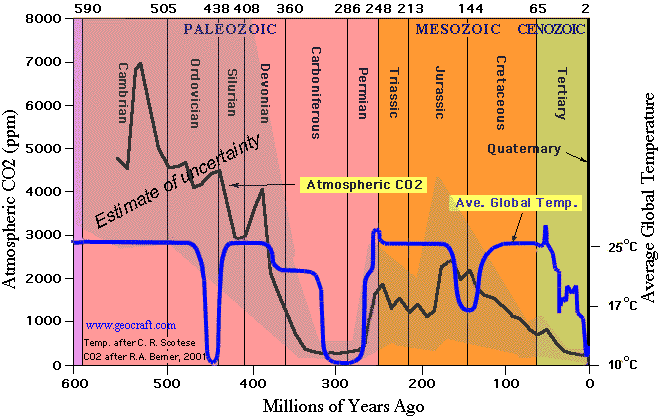
CO2 began decreasing at 144 MyBP, …… which forced the decrease in “green-growing” biomass, ….. which forced the starvation of the herbivore dinosaurs, ……. which in turn forced the starvation of the predator dinosaurs ……. and they all disappeared from the fossil record at 66 MyBP, (without any help from an asteroid strike)
The Age of the Dinosaurs – 252 million yBP to about 66 million yBP, ……. as defined on this Atmospheric CO2 and Global Temperature proxy graph, …. began with an increase in CO2 and terminated because of a decrease in CO2, to wit:
All animal species react the same, including humans. Their body size and their population numbers INCREASES during the food getting “good” time, ……. and their population numbers DECREASE during the starvation “bad” times.
Mass extinctions rarely wipe out whole phyla, but they can and do end classes, orders, families, genera and species.
Samuel-san:
There is overwhelming evidence that the Cretaceous Extinction Event was caused by a massive asteroid hit near Yucatan, Mexico which left a 180 KM wide impact crater.
This massive asteroid hit caused billions of tons of ejecta to be blown into the atmosphere which blocked out almost sunlight for years and caused photosynthesis to shutdown, which killed off roughly 90% of all plant and animal life on earth…
This event is clearly verified in geological data by a thin rock line known as the KT boundary, which has a high concentration of iridium which came from the asteroid impact.
Cheers.
SAMURAI – August 29, 2019 at 12:23 am
SAMURAI, …….. please note the status of both temperature and CO2 at the “65 mya timeline” on both of the following cited proxy graphs and then explain how it was possible that average temperatures remained above 59F ….. while CO2 ppm decreased to way below 1,000 ppm, …… to wit:
Temperature (T) and atmospheric carbon dioxide (CO2) proxy graphs here and here, …… proves that I am correct and that you are a sorely miseducated believer in the “junk science” that is deficient in/of common-sense thinking, logical reasoning and intelligent deductions.
Iffen Sunlight was blocked out for years n’ years the near-surface temperature would have ”dropped like a rock” …….and atmospheric CO2 would have drastically increased.
If you persist in believing said “asteroid event” ……. then explain the proxy data.
Eocene climate was comparable to mid-Cretaceous warmth, despite the only dinos left then being birds.
As an ice age progresses, reduced sea level causes a reduced Gulf Stream flow.
“Without the Atlantic conveyor belt, Europe can experience both colder winters and hotter and drier summers, making a more extreme and inhospitable climate.”
All climate change is bad. It’s a rule. Obedience is required for publication.
This, which says that the Gulf Stream has only a very limited effect on the climate of England and Northern Europe, and that it has the same effect on northern North America, doesn’t seem to be very widely known. That has been the conclusion of multiple studies.
Is it disputed or simply ignored as too inconvenient to talk about?
https://www.researchgate.net/publication/250969019_The_Source_of_Europe's_Mild_Climate
It is entirely speculative and arguably unphysical & impossible, and it is also not backed up by any empirical data on ocean currents.
I recently read a paper (sorry, no reference) where the authors studied the gulf stream over the US East Coast in the past, going back to some 15000 yrs ago. They did not find significant changes, even though the sea level has changed a lot in the meantime.
Nicholas
By ‘It” are you referring to the to the study I linked to above and all the previous studies coming to the same conclusion?
That paper seems to say their study utilized all the most modern data available from earth bound monitoring plus satellite data not existing previously, hoping to gain some new perspective.
Is there actual criticism of the particulars of the work somewhere?
I posted this comment in the wrong place. Sorry.
So his theory is that predominant onshore winds cause mild climates not the added heat from the ocean currents?
One must ask then: “How exactly did the northern oceans get this added heat for the winds to blow across if not from ocean currents transporting it from equatorial regions towards the poles?”
“It’s not the ocean currents its the air currents” is a bit disingenuous. Of course it has to be the air the warms the land seeing that the ocean does not flow onto the land. But, the ocean warmed the air first.
“It wasn’t the fall that killed him, it was the sudden stop at the end that did him in.”
Don’t they say that the winds get the heat energy from waters much further south?
Yeah, yeah, heard it before.
They were supposed to have fully understood oceanic circulation and its effects on climate before they told us we had to reverse the industrial revolution and plunge the world economy into an ‘ice age’.
Understanding that comes after the edicts just doesn’t wash.
Is this another “the gulf stream will shut down” and affect Europe’s climate type of scare? I’d like to hear Richard Lindzen on it.
Any one remember this. https://youtu.be/McsZ1U20W0M?t=75
“The climate at this time was very warm, with atmospheric CO2 levels two to three times the present day levels, and this contributed to extremely fresh Arctic waters.”
So the warm temperatures caused CO2 levels to be higher. Got it. But I am not sure how that led to all that fresh water in the Arctic Ocean. They kinda left that part out.
Spot on!
–“The climate at this time was very warm, with atmospheric CO2 levels two to three times the present day levels, and this contributed to extremely fresh Arctic waters.”
So the warm temperatures caused CO2 levels to be higher. Got it. But I am not sure how that led to all that fresh water in the Arctic Ocean. They kinda left that part out.–
They sort of did, though did mention it being 38 million years ago.
“Several recent modelling studies of the late Eocene (38 Ma) show that the combination of a fresh Arctic Ocean and its narrow and shallow connection to the Atlantic ocean circulation prevented North Atlantic sinking In these simulations, sinking is found either in the Southern Ocean or the North Pacific or both, but never in the North Atlantic. Furthermore, a modelling study with neodymium tracers enabled found the best match to Eocene observations with strong sinking in both the North Pacific and South Pacific Modelling studies have found that closing the Arctic–Atlantic gateway can trigger North Atlantic sinking under early Eocene boundary conditions”
https://www.nature.com/articles/s41467-019-11828-z
How does this explain “extremely fresh Arctic waters”
There are only two ways ice-free sea water gets fresher: Rivers and precipitation.
It would be one thing for them to postulated somewhat less saline waters up there…but extremely fresh?
In fact if the flow of all of the present day north flowing rivers in North America and Eurasia, plus rivers in Greenland and other smaller landmasses was high and the Arctic was closed in by land areas, it would be much fresher.
But if the Arctic ocean was closed off to a large degree from the world ocean, then what would have prevented it from freezing during the many months of low or zero insolation?
In order to be persuasive on this subject, there needs to be a coherent and comprehensive explanation for everything.
I do not think these authors have provided anything like that.
–Nicholas McGinley August 28, 2019 at 5:54 am
How does this explain “extremely fresh Arctic waters”
There are only two ways ice-free sea water gets fresher: Rivers and precipitation.
It would be one thing for them to postulated somewhat less saline waters up there…but extremely fresh?–
My guess is that some ocean floor core samples, indicate fresh water at that time- 38 million year ago.
Fresh water means that the Arctic was a lake, not an ocean.
I do not think anything like this was ever the case.
If we are discussing matters of science, and we wish to be understood and communicate our ideas effectively, we must use precise language.
Fresh water means…fresh water. As in not salty.
Somewhat less salty seawater is not fresh, and it is not extremely fresh. I do not even know what extremely fresh even means.
We have language that describes water with a range of salinities.
The Arctic ocean has always been an ocean.
It has never been fresh water.
“The team of scientists . . . Used climate modeling “
Should have stopped reading there.
Best approach, as I have often counseled, is to check the credits at the bottom of the article. If it says EurekAlert!, then you can be confident that whatever they are peddling, the truth is the opposite, and their flawed premise is alarmist propaganda.
They should make a movie about this. Where the arctic melts, and the fresh cool water stops the circulation. And then huge storms form and freeze the entire northern hemisphere. But one brave climate scientists treks north to save his son. Add images of New York flooding and freezing. Link it all to CO2 and call it “The Day After Tomorrow”. The premise is so bad, that even real climate scientists trash the movie.
Ohhh wait, that actually happened.
“…….used a combination of geophysical data and climate modelling to show…..”
Hmmm. “Climate modeling”.
Full stop.
This is now officially non-science.
Elvis and I just left the building.
I believe the opening of Drake Passage, enabling circumpolar current in the southern ocean, was far more significant, in terms of global heat distribution, than any changes in the Arctic:
https://www.eurekalert.org/pub_releases/2005-08/bas-sa083005.php
And the isthmus of Panama forming setting off the Gulf Stream started 2.8 mya.
Nothing but an hypothesis.
Poorly characterized and does not explain how a gradual process caused a dramatic shift.
Besides, the idea that the isthmus forming over 10+ million years between 13 and 2.6 mya, does not correlate with the onset of the Pleistocene very convincingly.
There was simply not a dramatic change in anything caused by a small strait closing.
On top of that, there is plenty of evidence refuting such a recent closure, and formation of an isthmus.
In fact it might have already been a closed isthmus over 10 million years ago.
And considering that ocean filling gyres that correspond to the primary global wind patterns and the effect of the Coriolis force, I am not sure exactly what is meant when they say that the Gulf Stream formed due to a isthmus closing. It would have been a very long time ago that a large enough open ocean existed to have completely changed the patterns of currents in the Atlantic ocean.
This is a highly speculative topic, and one should not mistake an hypothesis with something generally considered to be true, let alone anything like an established fact or truism.
It’s a persuasive hypothesis, supported by various lines of physical evidence, not just coincidence in time.
Formation of the Isthmus of Panama
https://www.ncbi.nlm.nih.gov/pmc/articles/PMC4988774/
While the Inter-American Seaway was indeed shoaling from about 5 Ma, its deep channel didn’t close until around 2.8 Ma. The Great American Faunal Interchange dates from ~2.7 Ma.
In the late Miocene, c. 10 Ma, Panama still harbored a Megalodon nursery.
So just as the onset of the Cenozoic Ice House is associated with deep channels opening between Antarctica and South America and Oz at the Eocene/Oligocene boundary, so too is more extensive NH glaciation correlated to the closure of such a channel between the Americas. Causation has been plausibly demonstrated.
Greenland might already have had an ice cap or caps in the Pliocene, but the Arctic Ocean was ringed by boreal forest, not tundra or ice sheets.
Above my pay grade. Thought it was one of those 97% consensus things. Silly me.
Really? Is that what happened 34 million years ago?
Most likely, the reason is the closing of the straits between North and South America, which provided flow of water between the Pacific and Atlantic oceans. Therefore, the reason is tectonics, rather than deep-water formation. Plate movements are also part of the climate forming system of the Earth.
Here’s another theory. The Younger Dryas, 27,000 to 24,000 years BP, was not a cold period but was actually a period of rapid warming that ended the ice age. This caused rapid melting of the ice sheets that flooded the surface of the North Atlantic with fresh water which blocked low salinity water from the south from flowing north, thus shutting down the Atlantic conveyor belt. When the rapid melting ceased the conveyor belt simply restarted. All of this fresh melt water was depleted in O18 which evaporated, further depleting its O18, then snowed out on Greenland, producing a false indication of cooling in the ice cores when fact it was a period of rapid warming following an ice age.
Way off on the timeline here.
27,000-24,000 years ago, the glacial maximum was still many thousands of years in the future.
The Younger Dryas period was more like 12.9-11.7 thousand years ago.
And how exactly does an influx of fresh water into an ocean bring to a halt oceanic circulation patterns that are driven by primarily by wind?
Not to mention the angular momentum of an entire ocean of water swirling around, in response to such winds persisting over tens of millions of years and blowing on the surface of the ocean?
The oceanic gyres are not a consequence of variations in salinity.
You are right. The time referred into the article was the end of the last glacial maximum, not the Younger Dryas, also a period of rapid warming and of course glacial melting.
The exact time of the end of the LGM varies quite a bit depending on who is opining.
Many estimates put the end of the LGM at around 18,000 ybp.
But others are as you say, 21,000 years ago or more.
Younger Dryas is so called because of a botanical ‘indicator’ species, Dryas octopetala, the geographical extent of which is used, independently of ice cores, to track subarctic conditions
So, no one thinks that all those studies saying it is the Rocky Mountain chain, and not the Gulf Stream, that is responsible for Europe’s mild climate (as compared to the same latitude in North America and Asia) are worth a single comment? Is there any particular dispute with the work leading to that conclusion or is the Gulf Stream just more fun?
What if Greenland’s ice melted fast – say in 2000 years, the freshwater would slowly be mixed up with the ocean’s salty water 34 promille. As this amount of freshwater is only 2% of the amount of sea water, the new salinity would go down with only half a promille or so to approx 33,5 promille. Would that change the currents?
It wasn’t only Greenland ice that melted, the whole interior North American ice sheet melted, discharging melt water through the Mississippi river, the Hudson river, and westward to the Pacific. A major flooding event that caused extinctions of several species. Google “Lake Agassiz.” It’s been suggested that an ice dam gave way, releasing the water of Lake Agassiz all at once.
My comment is about the future, not the past
If you want to know the future, first learn about the past.
To the Arctic down the Mckenzie River and Hudson Bay via the Nelson/Churchill Rivers as well, all at different time intervals during the big Melt. Over 2.6 MY of glaciation/de-glaciation has probably seen hundreds of these types of major melt water pulses in the Pleistocene alone. The 8.2-Kiloyear event and the The Younger Dryas 12,900 to 11,700 years BP was also probably caused by ice dams bursting and spilling major amounts of cold fresh water from Lake Agassi into whatever watershed drainage it was occupying at that time. No doubt this could cause significant global cooling and rapid sea level rise.
And, the St. Lawrence Seaway.
Greenland ice is a lot less than 2% of the total volume of the ocean.
Global ocean is 1.3 to 1.5 billion cubic kilometers
Greenland ice is ~3 millon cubic kilometers
1/500th as much.
So 0.2 %
you are right – thank you
“Our study helps to bridge the gap between climate modelling and geological observations of the deep past.”
Yeah, the gap between fantasy and reality can never be bridged. Nice try though. A for effort.
Did the Climate Meddlers allow for the joining of North to South America.
That would have had a major effect on how the circulation of the currants
occurred.
As with all moddling, lots of ifs and buts, but wait it real data.
MJE VK5ELL
A little OT, but since the link to WUWT’s ENSO meter seems to be busted, I’m posting the latest BOM ENSO INDEX which shows this week’s NINO 3.4 SST at 0.06C (-0.16C drop since last week) which means the weak El Niño cycle is officially dunzo:
http://www.bom.gov.au/climate/enso/indices.shtml
Over the past 70 years, there has always been at least one strong La Niña cycle every 10 years, and since the last one was in 2010, the next La Niña cycle will very likely be a strong one.
With a strong La Niña cycle in the making, combined with the PDO, AMO and NAO all about to enter their respective 30-year ocean cool cycles, and with the start of a possible 50-year Grand Solar Minimum event, I think next year marks the start of a 30-year global cool cycle, which will finally drive a stake through the heat of this stupid CAGW Hoax..
We’ll see soon enough..
Here’s my take on the ocean cycles. The PDO seems to have 8 year half cycles as well as the longer half cycle. It went positive in 2014 so will likely stay that way until 2022. This makes it difficult for a strong La Nina to form. In fact, I think one would probably be forming right now except for the strongly negative PDO. This means we will probably see a weak La Nina at best.
The AMO was still negative in early 1991 even before the Pinatubo eruption caused cooling in all ocean basins which could have masked a move into the positive phase. That would appear to place a 30 year half cycle into 2021 or later.
I think we are all looking forward to seeing what happens the next time the oceans go into their negative phases. Don’t think we are there yet.
This paper has disqualified itself from real science on three accounts. First it is published in the infamous Nature Communications. Secondly it is from the climatistic propaganda center at Stockholm University – The Bolin Centre for Climate Research. Thirdly use of climate modeling.
Is anyone else familiar with the theory of fluid Dynamics and angular momentum is what drives the ocean currents?
As I recall, the rotation to the east “stacks up” water on the westward edges of the oceans, and draws it lower on the Eastern edges, relatively speaking. Then gravity does the rest by moving the excess water away from the center of rotation toward the poles.
The oceans have huge mass, and hence huge inertia.
Global wind patterns that begin at the Equator with the Hadley cells leads to belts of wind in each hemisphere that are easterly at low latitudes and westerly in the mid to higher latitudes.
The spinning of the Earth then leads to close gyres, clockwise in the northern hemisphere and counterclockwise in the southern hemisphere.
Since the winds over the water are mostly unimpeded by frictional forces, they blow rather steadily on the oceans and over time have caused the large oceanwide gyres of oceanic circulation seen if one looks at a global diagram of ocean currents.
See here for a few basic diagrams.
Note the fairly exact match between prevailing wind patterns and ocean currents:
https://twitter.com/NickMcGinley1/status/1147684465768042496?s=20
What this is revealing is a net flow of a large amount of heat energy from the Equator to the poles.
“What this is revealing is a net flow of a large amount of heat energy from the Equator to the poles.”
I would say, a large amount of heat energy from the tropical ocean to the poles.
The heat energy is atmospheric and warmed oceanic waters.
Or the tropical ocean is the heat engine of our world.
Tropical ocean average surface temperature is about 26 C.
Tropics is 40% of earth surface.
Tropical ocean is about 40% of entire ocean and remain 60% the world’s
ocean has average surface temperature of about 11 C.
And entire average ocean surface temperature is about 17 C.
If entire average ocean surface temperature had an uniform temperature
of 17 C {not change amount of heat of surface entire ocean}, Earth average temperature would be much warmer.
What would be dramatically warmer if ocean surface had uniform temperature of
17 C is the average land temperature.
Or currently the global land temperature is currently about 10 C. And with uniform Ocean surface of 17 C, average land would about 15 C. Or many would call increasing, all land temperature by 5 C as being dramatic warming.
But I would point out that 15 C {59 F} is not very warm.
And more importantly I would point out, as was mentioned in above article, is we are living in an Icebox Climate. And often referred as the Ice Age.
Icebox or icehouse climate is probably a better term than Ice Age because icebox climate is polar icesheets {ice caps] and a cold ocean.
A cold ocean as is commonly said, 90% of entire Ocean is 3 C or colder.
Or the average temperature of entire ocean is about 3.5 C.
One reason “preventing” our ocean surface temperature from having a near uniform temperature of about 17 C is our average temperature of our entire ocean is about 3.5 C.
Or might easy to see that if the average temperature of the entire ocean was not 3.5 C but instead was 15 C, then a uniform ocean surface temperature could be closer to uniform temperature of 17 C, rather than merely an average temperature of 17 C.
Though I would not argue that if entire ocean was 15 C that average surface would be a lot warmer than 17 C, but with entire ocean being 15 C, it would make {or require} that the temperature of ocean surface is a lot more uniform- then it is now.
For instance, if the entire ocean temperature was 15 C, the average surface temperature of tropical ocean might remain close to 26 C, and 60% of rest of ocean instead of being 11, is say, 16 C
40 x 26 = 1040
60 x 11 = 660
= 17
And
40 x 26 = 1040
60 x 16 = 960
= 20 C
Or average ocean surface of 20 C
which I would say is more uniform compared to what we got, probably mean arctic average ocean surface water of about 10 C, and could freeze in winter, but would not have polar sea ice most of the time. Or like the Great Lakes or Hudson Bay is currently. And volume temperature of relative small arctic ocean could be say, about 5 C.
But ocean with average volume of 15 C is not a cold ocean and you aren’t in icebox climate, instead in a “greenhouse” climate or also called Hothouse climate.
Hothouse same thing or same meaning as greenhouse. I think Brits tend say hothouse. And a hothouse climate doesn’t polar ice sheets. And is not in an Ice Age.
So in sense having less extreme conditions found in an Ice Age, we can call this “warming”. And we have been warming since we left the Little Ice Age or about 1850 AD.
But average volume ocean in 1850 AD, was about 3.5 C as it is today. But some claim it’s warmed as much as .2 C. But we have not measured the ocean enough to say whether ocean is 3.5 C, presently.
We limited to saying Earth average temperature is about 15 C. The Southern Hemisphere is about 1 C cooler than Northern Hemisphere. And average volume ocean temperature is about 3.5 C. And these about numbers have not really changed in last 100 years.
Or when this religion began, and it was said that Earth average temperature was about 15 C, that was correct, then.
And it is now.
Though you can humor us, and give a number to tenths and/or hundredths of a degree.
Nice to get a laugh whenever you are living in an Ice Age.
Yes, I should have said from the tropics towards the poles.
The ice skater analogy is helpful. As the spinning skater pulls in his arms he spins faster, conserving angular momentum. As an ocean current heads northward it is “pulling in its arms,” conserving the angular momentum from the rotation of the earth as it gets closer to the earth’s axis. So its’ path deviates to the east. Or, to the west if it is going southward.
Easier just to remember it will turn to the right in northern hemisphere.
An ice skater bringing their arms towards the center of rotation accelerates the rate they are spinning.
Coriolis does not cause faster motion, but a turning.
It is only an apparent force, and the turning is only because of the reference frame being the surface of a rotating sphere, that part is true.
If a parcel of air or water moves north from the equator, it is moving into a part of the globe that is not moving as fast laterally. This imparts a deflection towards the right, or East.
But of course there is adjacent air or water in that direction. Air is moving in response to various forces. The primary impetus is the pressure gradient force. Air moves from zones of higher pressure to zones of lower pressure. As it moves in response to the PGF, Coriolis acts to turn it. These forces reach a balance when the air is generally moving parallel to isobars. This is collectively called geostrophic winds and the geostrophic balance. But other forces are at work as well. At the surface friction tends to slow the movement of air, and this causes surface winds in areas of rotating high pressure to diverge across the isobars. The same balance of forces causes air to converge into zones of low pressure.
Gravity also plays a role and is the fourth force which determines direction and speed of wind.
In the study of physical geography, we refer to this sort of air movement, that of migrating zones of high and low pressure, as the secondary circulation pattern. The Primary pattern is the general worldwide circulation that associated with the Hadley, Ferrell, and Polar cells.
The primary pattern is what the atmosphere is trying to do in response to solar heating which is the most powerful in the equatorial zone. The rising currents associated with the ITCZ are taken to be the starting point of all of these motions. The trade winds flow towards the ITCZ to replace air which is rising due to being heated. Rotation breaks up the bands into discrete rotating air masses.
The net effect of all of this winds up being rotating gyres of winds in each ocean basin, which gives rise to the oceanic circulation patterns we see. Since these winds have been acting on the surface of the ocean over very long periods of time, large amounts of water are in motion, and an area with light or no wind will not cause the currents to stop, because behind the water is moving and ahead the water is moving. The South Atlantic gyre sends water up the West coast of Africa which are is deflected towards the West, and the coastline of South America deflects much of this flow northwards to add to the Easterly currents driven by the trade winds. It all gets shoved into the Gulf Of Mexico and up the East coast of the US.
The thermohaline circulation, even if one accepts this model, is a tiny and gradual net movement superimposed on the far more energetic and rapid surface currents, which are driven by global air circulation and inertia. (It is, IMO, very likely that deep water only forms episodically, when and where sea ice is actively forming and brine is being displaced by the freezing process.)
Adding in some less dense water at the surface in the North Atlantic is not going to cause all (or any!) of these motions to cease, or even to slow. The pace of water which is diverted from surface currents to the deep ocean is on a scale with will take many hundreds of years for water to flow from the surface to the deep ocean and then to make it’s way back to the surface. About the same scale of time as seen in the ice core lag time between temp and CO2.
Surface currents move at speeds measured in meters per second, (or mph, which is of the same order of magnitude). The Gulf Stream in places is about 2.5 meters/second (5.6 mph). But generally currents are far slower than this. Thermohaline flow is so slow it is inferred , not measured.
The upwelling parts of the THC cartoons do not exist, or at least no one has ever measured or sampled any place where bottom water rises to the surface. It is the coldest and densest water in the ocean…how can it rise to the surface? That would be like a lead balloon rising to the stratosphere. The upwelling part of the flow is a general and gradual movement upwards over wide areas. In places where upwelling is a surface feature, typically very rich fisheries, the upwelling is from a few to several hundred feet down.
Like the atmospheric energy budget cartoons, there is no place anyone can point to, go and get a measurement, and characterize it.
It is a theoretical construct.
For sure deep water forms, but it is not a constant widespread general phenomenon, but a localized one taking places in very specific circumstances.
Likewise upwelling of bottom water obviously occurs, but it is a broad and general movement that takes places as water is warmed and new cold water flows in. That bottom water is very close 0°, and in places is likely to be supercooled.
Look at the THC cartoon: It shows cold water breaking off from the bottom flow and in the span of a few thousand miles rising to the surface in the middle of the hottest part of the Indian Ocean as a warm current.
If that does not make you laugh, think about it some more.
Global warming alarmists just can’t help pontificating on CO2, even when it has nothing to do with a study. EurekAlert’s editors again demonstrate the CO2 monomania that shuts down higher level crticial-thinking. The study tests the hypothesis that a combination of salinity differences and ocean geography alone could generate the Atlantic meridional overturning circulation (AMOC). CO2 is never mentioned except in a passing reference to an unproven theory that decreasing CO2 caused the Eocene-Oligocene transition (EOT) ~34 million years ago; a theory the study never even attempts to address. EurekAlert manages to toss in this entirely unrelated thought thanks to the obsession with CO2, the whole CO2, and nothing but the CO2:
What the study actually says about the “sinking in the Atlantic” is:
The paper itself waffles at the end, where they try to compare the relative significance of their arctic closure and the opening/deepening of the Drake passage between South America and Antarctica in leading to glaciation in Antarctica. Not surprisingly, they prefer their newly-announced arctic closure. Quite possibly, both events, which took place at about the same time, contributed to the start of the modern ice age. They seem to have done a meticulous compilation of paleogeographic data, and give thoughtful accounts of how changes in submarine topography led to changes in circulation.
AT the end, the paper brings in the role of CO2 as the “Invisible Hand On The Thermostat” that made the temperature start going down. No reference to the solubility of CO2 in sea water as it got cooler, so this is very standard climate stuff. Also, we have to assume that their climate models don’t include clouds and their effect on albedo, and it seems extremely likely that major changes in ocean circulation are going to have major effects on cloudiness.
Until there’s a viable explanation for the short-lived Antarctic deglaciation at around 15 Ma, the causes of the change to ice-age conditions are good subjects for research and debate. Which this paper is a contribution to. But no research is needed to know that we’re in a long-lived cold period, every glacial interval seems to have got colder and the Northern Hemisphere ice sheets got bigger than the one before, and now the current interglacial is winding down.
SR
Some years ago Bill Illis mentioned something about cratons and Antarctic tectonic drift as an explanation for the 16 Mya temporary deglaciation of Antarctica. I don’t remember more details.
As long as the sun warms the equator waters, currents transport heat to the poles. The temperature difference generates the power for these currents. Of course Coriolis forces cause these currents to rotate clockwise in the northern hemisphere. Coriolis forces do not cause currents. Its illogical to think that there were not northward currents in the Atlantic prior to 35 million years ago. As the poles cooled 35 mya the temperature difference would increase the speed up of the currents.
This is not the first time that climate scientists have shown their total misunderstanding of what powers currents. I ran into this article where climate scientists were trying to explain why the southern hemisphere was cooler than the northern. One of the explanations was that ocean currents caused heat to be transported from the colder southern hemisphere to the warmer northern. To any Engineer this is a violation of the second law of thermodynamics. The more logical conclusion is that there is something different about the southern hemisphere. But because CO2 is their driving motivation they wont even look.
I know of no mechanism whereby a temperature difference will induce rotation in an ocean basin in a particular direction.
The ocean currents are wind driven.
For the most part, ocean currents match wind patterns very closely.
Easterly near the equator, westerly in the mid latitudes.
https://twitter.com/NickMcGinley1/status/1147684465768042496?s=20
There are of course parts of the ocean circulation and even strang currents that are not strictly wind driven, and the largest part of these motions are powered by differences in salinity and temperature.
A well known example that is easy to point to and quite dramatic is what happens in the Mediterranean Sea. In this area, evaporation from the surface is very high, and at the surface of the Straits of Gibralter water is constantly flowing into the Mediterranean. At the far eastern end of the Sea, evaporation is especially high, and results in very heavy water that is also warm. This water sinks and flows back towards the west, and exits into the Atlantic at depth in a continuous outflow of deep (but not bottom) water that is very dense but also rather warm.
In the Gulf of Mexico a complex pattern called the Loop Current exists, in which water actually does a 270° or so looping pattern, and water flowing out of the Gulf into the Florida Straits passes near the water flowing into the Gulf from the south between Cuba and the Yucatan Peninsula.
Periodically rings of flow break off from the Loop Current and drift Westward. These can persist for a surprisingly long time before impacting a coastline and being disrupted.
It would likely surprise many people when they learn that the water comprising the loop current can pile up above sea level by as much as 24″ (60cm, or two feet), above surrounding waters.
In some cases, currents arise due to water having to balance out other currents that are wind driven, as is the case with the Loop Current and other places where land masses and the contours of the sea floor cause water to flow in a certain way with no matching prevailing wind at that exact location.
Other currents are wind driven but flow against the general overall wind patterns. One must keep in mind that prevailing winds are an average flow over time.
The North Equatorial counter-current is an interesting case of a wind driven current which flows opposite the overall mean wind flows in the equatorial zone.
When one delves into the specifics of all of the subsurface flows, to the extent that they are known, it is immediately obvious that these are hugely complex. The difficulty in studying them means that there is no continuous monitoring on anything like a grid, in order to understand how these flows vary over time.
There is a tendency to oversimplify, and also to makes assumptions amount the persistence of deep water currents that may be unwarranted.
This report from Stockholm University is a meaningless logically dysfunctional non-sequitur.
A. Closure of the Arctic Ocean from tectonics 34 Mya started the AMOC and made it colder.
therefore …
B. Imagine what global warming would be like! 😬
From the article:
The climate at this time was very warm, with atmospheric CO2 levels two to three times the present day levels, and this contributed to extremely fresh Arctic waters.
If there were few if any glaciers to melt in the Arctic (I don’t think Greenland was glaciated yet), why would the Arctic Ocean be any fresher than any other ocean?
All the world’s oceans have clockwise circulation in the Northern Hemisphere and counterclockwise circulation in the Southern Hemisphere, due to the Coriolis acceleration. In the western North Atlantic ocean, the east coast of North America runs SW to NE, so that warm water from the Gulf of Mexico flows NE along the coast to south of Greenland, where it splits, with one branch flowing north between Greenland and Scandinavia, the other flowing east towards Europe. Water from the Arctic returns via Baffin Bay in the cold Labrador Current.
There is a similar circulation in the North Pacific, with warm water flowing NE along the coasts of China, Japan, the Koreas, and the Kamchatka Peninsula, and cold water flowing SE along the west coasts of Canada and the United States. Because of the narrowness of the Bering Strait, there is little exchange of water between the Pacific and Arctic Oceans.
If there was a major warming such that most of Greenland’s and/or Antarctica’s icecap melted, sea levels could rise enough to flood much of Canada’s archipelago north of Hudson Bay, so that Baffin Bay would be much wider, and the cold Labrador current would be stronger, while most of Greenland would remain above sea level. This could push the Gulf Stream farther east, but not eliminate it entirely, since the SW to NE orientation of the east coast of the United States would remain.
But such a flood would inundate most of England, western France, northern Germany, Belgium, Holland, and Denmark, so that a slight change in the Gulf Stream would be the least of their worries.
Not to worry, though–the heat capacity of the Antarctic and Greenland ice caps is so huge that it would take them thousands of years to melt even in a drastically warming climate, and there would be time to adapt.
If you took all of that weight off of Antarctica and Greenland and added it to the sea floor, several isostatic changes would take place.
One could go into all sorts of specifics ideas about the results, but since it is not gonna happen, it seems pointless to spend the time.
For one thing, we would have a lot of new land, and for those places to melt, places too cold now would no longer be too cold.
Nothing last forever, and every thing will need to be replaced at some point.
Many disasters are not hypothetical but certainties and only a matter of time, and many are no less consequential.
We could talk about how much energy would be required to bring all that ice to the melting point and then change the phase to liquid at that same temp.
Very fresh water in the Arctic ocean means the freezing point is nearer zero c then instead of -2 c. Therefore it would make it easier to freeze especially during winter and these levels of CO2 would not prevent this.
When there is a future major change in the circulation of the Atlantic ocean, whether thousands of years later and natural. The Gulf stream and NAD moves further south and it has never been shown with proxies to fail or shutdown. In the worse case scenario cold polar like ocean water in the North Atlantic ocean and North Sea would hugely cool both winters and summers. There is no mechanism how warmer and drier summers could happen over Europe with Atlantic ocean temperatures many degrees cooler than now. The jet stream would be well to the South of Europe and Atlantic systems would frequently move into Europe causing much wetter and cooler summers, but drier and much colder winters.
The climate of Europe, north Asia and North America/Canada would all be affected because they all surround the Arctic ocean and failure of warmer water moving further North would freeze the Arctic ocean completely even in summer longer term. Although these are based on scientific evidence from proxies not a model guess with no evidence.
In any sort of honest and open climate of scientific discourse, obvious mush like we see being put force by various disciplines that consider themselves to be part of “climate science” would be quickly put to widespread scrutiny and criticism.
Shutting down ocean currents which are wind driven by changing the salinity of surface water in a relatively small area (consider the relative volumes of the ocean and rivers and land ice melting, the turbulence and mixing of surface waters by storms etc, and the small size of this region when one looks AT A GLOBE) is not a well supported notion. Even the terminology of thermohaline circulation has been recommended to be changed to meridional overturning to better describe what is thought to be taking place.
Simplistic ideas with little supporting evidence are a staple of modern climate science (and by extension fields that overlap with it) however, and when they are not challenged, and critical thinking is actively discouraged, dissention from group think is not just frowned upon but punished or not even tolerated, it is predicable the end result will be very far from anything resembling an advancing body of well supported knowledge.
Most of the ocean currents are wind driven and are not shut down by changing salinity of surface water or needed to be shut down. This is because the ocean current often goes the opposite off the winds above 50N for example in the NH especially around Europe. The reason this occurs especially around western Europe is because the AMOC keeps the motion going into the Arctic ocean.
What should happen with ocean currents in the mid-latitude cell is that the prevailing winds are towards North Africa. They then converge in the Hadley cell with the north-easterly trades. Therefore the ocean current should move south down the side of Africa towards the tropical ocean. Instead what happens the AMOC moves more of the current north of here past the UK and into the Artic ocean. That is against the atmospheric winds which would rather push south.(A)
When the wind and ocean currents just follow towards North Africa with what should be the usual westerly flow and converge with the north-easterly trades, that’s when we get an major ice age as proxies have shown in the past.(B)
It’s the energy distribution of the ocean south to North in the mid-latitude cell around North Africa that changes and this is much less wind driven. This is determined by the strength of the AMOC and get a variation between A and B. It is at a point of divergence in winds and not surprising this has become very unstable during ice ages with short dramatic temperature changes.
The notion of a great, coherent oceanic “conveyor belt” as a controlling mechanism in global surface climate is inconsistent both with dynamical theory and with oceanographic observations. At best, thermohaline factors produce a minor adjunct to the wind-driven circulation, with denser parcels of surface water diffusing slowly into lower layers. The practical effect lies primarily in the formation of bottom-water in the polar regions, which is distributed more globally and ventilated in a very sluggish and incoherent overturning cycle. As Carl Wunsch points out, as long the winds continue to blow, the surface currents that indeed affect climate will persist. See, inter alia : https://www.yaleclimateconnections.org/2007/10/common-climate-misconceptions-why-a-gulf-stream-shut-down-and-a-new-european-ice-age-are-unlikely/
“During the warm climate, buoyant fresh water flooded out of the Arctic and prevented the ocean-sinking that helps power the conveyor. We found that the Arctic-Atlantic gateway closed due to tectonic forces, causing a dramatic increase in North Atlantic salinity.”
Pure nonsense. There was no Arctic-Atlantic gateway at all during much of the Eocene. We know this with certainty because there was an extensive exchange of land animals, e g flightless birds and early primates between North America and Europe. On the other hand Europe was separated from Asia by the Turgai strait. That is where the freshwater efflux from the Arctic went.
What happened at the end of the Eocene, the “Grande Coupure”, was that the Turgai strait closed, asian mammals immigrated into Europe and there was no more exchange across the North Atlantic.
Early Oligocene was as a matter of fact when the deep North Atlantic gateway opened not closed:
https://www.nature.com/articles/35073551
“The climate at this time was very warm, with atmospheric CO2 levels two to three times the present day levels, and this contributed to extremely fresh Arctic waters.”
Sure, sure. We all know how fresh the water is in e. g. the very warm Red Sea or Persian Gulf. That the Arctic Ocean freshened during the Paleocene-Eocene was because it was practically isolated and received large quantities of fresh water from rivers, and the climate was cool enough to limit evaporation. In other words it was much like the Baltic or the Black Sea today but on a larger scale.
This would seem to be a severe case of modeling madness.