Watching the current maps and models, it appears the 2019 Atlantic Hurricane Season is off to a slow start. For people that the depend on disaster porn (climate alarmists, media) that means no weather events to claim as being climate driven.

With no current areas of storm development, 2019 has had the slowest start since at least 2004 when Hurricane Charley was named on August 9th, 2004.
In a private email with top-notch hurricane forecaster Joe Bastardi, he concurs with that assessment and adds:
“…there is a chance that this could tie 1977 for lowest August ACE.”
ACE= Accumulated Cyclone Energy, an index used to measure TS/Hurr energy released into the atmosphere. 1977 had the lowest season for ACE.
NHC says nothing is likely ahead in the next 5 days:
Tropical Weather Outlook
NWS National Hurricane Center Miami FL
800 AM EDT Wed Aug 7 2019

For the North Atlantic...Caribbean Sea and the Gulf of Mexico:

Tropical cyclone formation is not expected during the next 5 days.

$$
Forecaster Stewart

Assuming no new tropical cyclones form by August 9th, the slow start of named storms would then go back to 2001 when the Tropical Storm Chantal was named on the 14th of August.
The peak of the season lies ahead in September.

Good news, dammit!
If it doesn’t pick up soon, it looks like enhanced CO2 levels could give Greta smooth sailing from GB to USA
Before you know it, they’ll claim the absence of storms during her trans-atlantic passage is proof she can perform miracles.
And Lo! Saint Greta commanded the winds to be still, and the seas to be calm, and verily it came to pass.
And the reason is ?
Climatechange 😀
It’s definitely the new normal.
Look up the word “halcyon” in the dictionary.
At last, we have a real one!
May the weather gods have mercy on little Greta! But maybe she has the ability to calm the seas, like an oil spillage. Waters have been split before, should Greta be any less than Moses?
“There are more things between fracking and flaring, Horatio, than are dreamt of in AR5.”
In God We Trust
Hell it is good news they act like they want one to come bunch of idiots
But hey!
The media and their Liberal- Democrats only respond to theories.
Not facts.
Sigh,
There’s not much comfort in saying that this is the slowest start of the tropical weather season since 2004, given that 2004 and 2005 were the two worst years in the SE US and Florida in many decades, in terms of major hurricanes making landfall and doing severe damage.
If you live in Florida, you never relax until December.
What do a tornado,a hurricane and a redneck divorce have in common? Somebody’s gonna lose their trailer.
But they get to keep their sister
What do tornadoes and rednecks have in common? Both love trailer parks.
I recall a cartoon where two angels watched a tornado destroy a trailer park and commented, “You think by now they’d have figured out the guy upstairs hates these things.”
I recall a cartoon where two angels watched a tornado destroy a trailer park and commented, “You think by now they’d have figured out the guy upstairs hates these things.”
Don’t jinx it!
When Berry was threatening, I thought super active hurricane seasons was the ‘new norm’. /sarc
But there has already been a (short, weak) hurricane this season: Barry (https://en.wikipedia.org/wiki/Hurricane_Barry_(2019) named for Oboma? :-))
Also, as I recall, climate models predict _fewer_, but on-average more powerful hurricanes. So hold on to your hat (and don’t move to Huston-Key West).
I know that makes me a Bad Person, but I truly wish a Cat 5 would stall over Mar-a-Lago for a week. 🙂
Like Obama, it wasn’t as significant as they touted. It’s even questiable whether it was truly a hurricane.
And if people quit advocating violence the world would be a better place.
Any particular reason why you would bring havoc, destruction, and death to a big chunk of Florida?
He talked about a landfall ?
Can a ‘cane stall over land WITHOUT making a landfall? You might want to explain that to me.
Maybe he wanted the eye to stall just off-shore so the storm would maintain its fury for awhile.
Sounds like he doesn’t care who gets hurt as long as some hurt rains on Trump. Others would be devastated, trump not so much.
Struggled to find that extra estimated 1 mph to classify it as a hurricane I recall…….
Probably the first politically categorized hurricane in history!
“Based on these data and the possibility that the strongest winds were not sampled, it is estimated that Barry became a hurricane around 11-12Z despite its less than classical appearance in satellite imagery.”
Gives you a lot of confidence in how NHC determines when a storm becomes a hurricane, right?
Rather like those who know the earth is warmer, they just can’t find the missing heat.
No, it wasn’t the first. You won’t find a single land station or buoy that recorded Cat III winds when Irma came ashore near Naples Florida in 2017 but that is what was reported at the time and remains the record.
Fewer but larger was just spin to explain the massive hurricane drought from 2005-2017
It doesn’t make you a bad person, chris. It makes you an evil sub-human.
The narrative changed to “(possibly) fewer but on average more powerful hurricanes” because holes were poked into historical hurricane trends that suggested an increase as the globe warmed…in conjunction with hurricane droughts during “hottest years evah.”
But there are still prominent climate scientists clinging to the “more frequent and more powerful” mantra. https://www.climatecentral.org/news/study-projects-more-frequent-and-stronger-hurricanes-worldwide-16204
Nah, he’s just a useful idiot with TDS.
You are correct, it makes you a bad person and a bag of excrement. This topic is for climate discussions not stupid political crap.
In the department of “Be careful what you wish for,” exercising a socio-political grudge by calling down the Wrath of God on Mar-a-Lago won’t satisfy anyone. That pad is built to high standards. Marjorie Merriweather Post, the cereal heiress and one-time richest woman in America who built the joint in the mid-1920s, did not chintz on construction methods. Besides, Mar-a-Lago is beautiful, and a National Historic Landmark. That will still be true as long as the estate is maintained, whether it’s occupied by someone you adore, or by someone you despise. Even if the vile and unfunny Kathy Griffin should possess it, Mar-a-Lago would still be a pretty house.
The rest of a Cat 5 hurricane stalled over Palm Beach would inflict misery on less swish precincts like West Palm Beach, and the snakes and raccoons in nearby natural preserves. Keep in mind the old African proverb, “When the elephants fight, the grass gets trampled.”
wishing destruction and death on others. how nice. another deluded democrat. I suggest you go see your therapist for treatment of your TDS.
From the article: “…there is a chance that this could tie 1977 for lowest August ACE.”
ACE= Accumulated Cyclone Energy, an index used to measure TS/Hurr energy released into the atmosphere. 1977 had the lowest season for ACE.”
Man, we can’t count on that CO2 for anything! CO2 is letting us down and not warming us up like the pundits claimed it would.
1977, that was around the time the “experts” were claiming we were going into another Ice Age.
The Alarmists must hate this! There’s nothing for them to exaggerate! 🙂
Tom,
“The Alarmists must hate this! There’s nothing for them to exaggerate!”
Whoooa!
To the south of London, we had Small Shower Archibald today.
Probably rained for twenty minutes, and sometimes it was certainly more than just laying the dust.
Caused the traffic on the M25 [London’s Orbital Carpark/Motorway] to slow even more than usual.
I fear that our water-melon friends – with their usual dedication to the truth – will conflate that to Super-Storm Archibald, name to be retired.
Nothing to exaggerate indeed!
Auto [just a little teensy, tiny baby bit /Sarc!].
“Small Shower Archibald”
That’s funny. Yeah, the real CAGW fanatics are now naming thundershowers. What a joke!
This Thundershower Archibald name raises a question in my mind: Do these weather people use a lot of “A’s” when naming thundershowers or is this thundershower the first of the season, and the next one starts with a “B”, like hurricanes are named?
+42
Let’s see, when I was learning about this stuff way back in the early 80s, we said that weather was a nonlinear chaotic system and not to count our chickens before they hatched. Had this long section about Lorentz in DiffEq where we painstakingly hand-graphed 100s of solutions to equations just outside the band of stability. I learned a good deal about equations that were sensitive to initial conditions in that class. I also was very thankful when I could hand off rote tasks like that to PCs a few years later.
Hurricanes are strange critters that sometimes sprout seemingly out of nowhere. When the Atlantic looks like this, I would worry more about a continental low swinging down into the Gulf and intensifying into a minor storm then just about anything else.
We used to send teams to the eastern Caribbean from July to October just to fly missions against all the slightly organized waves in the Atlantic to get the initial conditions right for the early models and monitor anything that actually developed. I understand that weather satellites are collecting most of that data now.
Berry was a continental low that swung down into the Gulf.
“Hurricanes are strange critters that sometimes sprout seemingly out of nowhere. When the Atlantic looks like this, I would worry more about a continental low swinging down into the Gulf and intensifying into a minor storm then just about anything else.”
OweninGA
At last, someone with genuine knowledge and experience.
Just because a mid-latitude continental low storm centre such as Barry picks up energy and wind strength when it moves south from Texas into the Gulf doesn’t turn it into a tropical hurricane.
In the north of Scotland hurricane force 12 winds can be experienced, but that does not make the storm that created them into a hurricane.
I am puzzled as to how it is possible for a 16 year-old girl to have the almost 40 years of knowledge and experience that you have.
Ja. I told you.bThe big droughts are here. Hold on for the next 7 years…
Works for me. Still lots of work to do in the Houston area since Harvey.
Good news also for Greta Thunberg who has to sail the Atlantic.
And sail back, I guess, in the autumn [or early winter].
Rather her than me.
Crossing Atlantic in a modern commercial ship is one thing, especially in May or June.
In a sailing vessel, sixty feet [~18 metres] long, the passage is decidedly different, as rightly noted by many posters here on previous related threads.
And the return voyage towards the end of the year – not at all my cup of tea.
And I had forty-five years in shipping!
Auto
Don’t forget the Kraken!
I got a cup of coffee that says she is not going.
The boat is going to depart from an “undisclosed location”. Tells you all you need to know.
Alternate Possibility:
They disclose the location and set out in the middle of a media blitz, playing it up for all it is worth.
Bailout Point #1
After getting out of range of news cameras and well-wisher boats, they turn south to cross the Channel and head straight for Normandy.
Bailout Point #2
Ireland, any number of small coastal villages are suitable.
Bailout Point #3
Reykjavik, Iceland. After a few days at sea, everybody has had enough of this little brat. After the horrible Small Boat – Big Sea experience the brat has just been through, there is no chance she will ever get on board a boat ever again in her life. Unfortunately, the only other way off Iceland is by commercial air travel. We all know Greta will never do that.
This is not a problem.
The adults simply use Iceland’s lax immigration policies against them. (I know, it is not a nice thing to do.) The adults simply file for Refugee Status on behalf of Greta and leave her there.
Problem Solved.
Pardon an old layman but, when there have only been two named storms and Andrea became a tropical storm by one mile per hour and Barry became a category 1 by one mile per hour, why am i suspicious. I watched both on the nullschool.net site and couldn’t see anything close to the stated wind speeds. I do realize that it is not a perfectly accurate site but is usually pretty close.
One element of the Hurricane story is the present location of the Intertropical Convergence Zone or Doldrums off the coast of Guinea, West Africa, rather than being located further north off the coast of Senegal.
The following satellite images and weather chart illustrates this point: –
Worldview 04 August 2019
Meteosat 0 degree Infrared 3.9 Western Africa 04 August 2019 2000 UTC
Ventusky Conakry 04 August 2019
I much prefer the use of ACE instead of Named Storms as a metric of tropical activity. The threshold for naming a tropical cyclone a ‘tropical storm’ has changed greatly over the last few decades. Hurricane Specialists at NHC used to have stricter criterion about upgrading cyclones and now-a-days, satellites give us much more detailed and timely info on what every little cloud cluster is doing.
Twenty years ago, Gil Clark wouldn’t have wasted an advisory on the likes of Andrea, let alone call it a 6-hour tropical storm.
The children just aren’t going to know what hurricanes are.
Think of the children!
Chris, please do not wish ill for anyone.
The alarmists will take their cue from the Propaganda Press and go into silent running.
We could go the whole hurricane season without so much as a tropical depression and they will spend the entire season complaining about Trumpisms. For them it is all about misdirection. But be sure that they will become extraordinarily clangorous just as soon as a storm gets its name. Oh we will hear it all then.
Um…I guess the hurricanes became so strong due to global warming that they blew out?
Don’t worry, they’ll be back. If there is ONE thing I count on it’s that the weather is always changing.
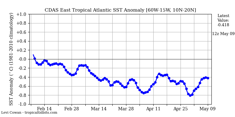
I wonder what the sea surface temperature is doing between the West coast of Africa and the Caribbean?
Oh, here’s the SST anomaly difference …
https://earth.nullschool.net/#current/ocean/primary/waves/overlay=sea_surface_temp_anomaly/orthographic=-33.80,1.07,610
woops…..
The water temp is not the limiting factor for tropical development, and besides with no clouds the water can warm pretty quickly.
The peak of the season is not for another full month.
It is not at all unusual for nothing to be happening in early August, but very unusual for nothing to be happening around Labor Day.
Over the next four weeks, the climatological frequency of storms goes from about one per ten years this week to nine to ten per ten years 4 to 5 weeks from now.
This is the time to be making preparations and stocking up on supplies, no matter what the weather is doing.
Well I just had a discussion with a facebook group FULL of alarmists that are claiming this is terrible news and it means that the oceans have heated up so much and the arctic is so free of ice that there will not be a winter ever again. They assured me that no hurricanes was worse than multiple hurricanes because the energy in the system just builds up and kills us all if there are no hurricanes.
So the moral is
More hurricanes — global warming.
Fewer hurricanes — global warming.
No hurricanes — global warming with zing.
It’s obvious that the slow start to hurricane season is caused by global warming.
We sail the Caribbean during November to June. The temperature measured end of May between Granada and Trinidad was 34 C the firs year, the year of the big storms. 31.5 C last year and 31 C this year. In addition, the swimming, diving this last season required a shortie wet suit or top to avoid cold. Previous years a suit alone was all one wore. Daily temperatures were more pleasant as well this year. I am no expert, but my prediction last year was for a down year and I repeat that for this season. It’s early. We hope for the best for the many friends we have made there on land and sea.
Several factors contributing to this slow start to hurricane season.
One big one is the anticorrelation between El Nino years and Atlantic hurricane season tropical storm formation/intensification. The season started with a weak El Nino in place.
Another which is important at the present time is a huge area of dry air in the eastern and central portions of the tropical Atlantic ocean.
With such dry air in place, there is nothing coming off of Africa from which a disturbance might develop.
This can of course change completely over the course of a month.
I can say for sure that when we had the very active seasons in 2004 and 2005, things were very slow early on in the seasons, and then it was like someone hit a switch, and every area of clouds seemed to rapidly intensify into a strong tropical cyclone.
Note that 2004, despite having a slow start, would go on to be an epic tropical season in the Atlantic.
I was living very near the coast in Deerfield Beach at the time, and it was no fun at all.
Interesting that in 2004, a unusual El Nino pattern was in place, called a Modiki El Nino, which was characterized by above normal temps further to the west in the Equatorial Pacific than a typical El Nino.
Rather rare.
It did not produce unfavorable wind shear conditions in the Atlantic hurricane basin.
For a period of about two months it was one hurricane or strong tropical storm after another, and many of them hit Florida.
One of the two storms that had the worst effect on the area I was living in at the time was Jeanne.
After hitting Haiti and causing huge damage, it moved north and was for a time north of South Florida and moving northeast, which in nearly every case (every single case as we were told at the time) is the end of the threat for the US.
It then slowed and did something which I believe was unprecedented, or nearly so: It began to move back south while retaining strength and actually intensifying. During those days we were being assure that it was temporary, and all the models had the thing quickly resuming northeastward motion and moving away from Florida and the US.
But the storm was not paying attention to the reports or the models.
It kept doing what it wanted to do, and for several days defied all predictions, finally completely a loop de loop and, while strengthening, began to head directly towards the spot where I was living.
This was the second time that season and the third time in my life a major hurricane was close and heading straight towards where I was at the time.
(The first time being when Elena did a hard 90° right turn and headed straight towards the West coast of Florida, just north of where I lived while in college and only a little north of my families plant nursery. Putting us and our property directly in the right front quadrant of a quickly approaching major hurricane. Incredibly, the storm came right up to the coast and, after moving in such a completely unexpected and unheard of manner, then stopped dead in place with the outer fringes just brushing where I was living at the time!
It sat there, and sat there, for hours, and then days, near cat 3 status.
The it started moving and went back the way it came.)
Jeanne wound up veering north before it made landfall, as Frances had done a few weeks prior, and Deerfield Beach only got brushed by moderate T.S. force winds, for the second time that season.
The worst part of the whole sequence of storms was losing power, for quite a while both times, in Jeanne and Frances.
A lot of very weird things occurred that season, including another storm that was a major hurricane, hit land, weakened, and did a complete loop and re-strengthened and hit land again after it should have been moving away. That one was Ivan, which hit the Gulf Coast as a hurricane, and then moved across a large part of the eastern US before going offshore near Cape May as a TD. and then moved southeast, and then southwest, moved all the way south to cross the Bahamas and South Florida, and then became a tropical storm again, and controversially was given the same name, Ivan. It hit Texas as a depression after weakening prior to landfall.
That season there were at least three hurricanes and one TS that did loop de loops at some point in their lifecycle.
And maybe a couple of more.
Here is a wiki article on that season.
The next year, IIRC, started off about the same, kind of nothing special, before becoming the epic and worst ever season most of us probably remember all to well.
In addition to the storms, it became a time of rampant alarmism regarding the future of hurricanes. That was when the worst of the doom mongering first reached a crescendo.
Let us hope with all sincerity we do not have anything like that time period again.
Although what happened next is at least equally noteworthy…the US and the Gulf of Mexico entered into the longest and most profound hurricane drought in recorded history.
I would like to see another 2006-2017-like period without the 2004-2005-like seasons first.
A little off topic, but the climate alarmists have found another problem to hype. The Great Lakes record levels are due to …you guessed it, climate change. Pretty sure is was just 10-12 years ago that they claimed the record low levels of the Great Lakes were due to Global Warming (term used at that time).
Lake levels fluctuate? Uh-oh. I’m SURE that’s never happened before. Last I heard every lake level everywhere was exactly the same, all the time, for ever and ever. Loch Ness, Lake Superior, and Lake Inferior. QUICK — reach out and blame someone!
I have faith,our comrades over at “The Weather Channel” will solve the shortage just as they have solved the shortage of heat this Summer,just as they now issue “heat warnings” at 27 C, they will now name each storm in 3 acts.
So the build up will be alpha,the peak intensity will be beta and the fade away will be ceta.
This is easy as that is what old time propagandists have always done.
By seasons end;”Most Storms evah”.
I get mail— From the Sigma Xi President: A Call to Action August 05, 2019
“ Each day brings news of how our climate and our environment are historically changing, and research shows that human activities and population growth are the leading factors. With these changes comes an urgency to find solutions to ameliorate the impact of the rising temperatures that are causing extreme weather events, rising sea levels, and the alteration of plant and animal habitats. ” Urged to attend upcoming conference —“Our Changing Global Environment: Scientists and Engineers Designing Solutions for the Future,” which concludes “.. with the first ever Sigma Xi STEM Art and Film Festival, which explores science through visual arts.”
I guess the Sigma Xi President was raised on “Blowing Away in the Storm” of instead of “Singing in the Rain.” It is the 50th anniversary of Woodstock.
Could slow start mean energy building for big one ?
I was going to say the same thing… as parody.
I suspect others will give you a better and more thorough explanation, but just in case I’ll give you my take. The energy that creates hurricanes comes from the latent heat of water off the western coast of Africa. The waters are cooler than normal. Moreover, energy can stop storms from developing. Strong upper level winds blowing from the west can disrupt a storm from growing. This is called wind shear, and it has been happening this season.
So, in a nutshell, the energy needed to form a hurricane has been largely absent, and the energy that is in the atmosphere has been hindering their formation.
There is no energy ‘building up’.
technical technical technical… Barry was real people… July 13th, 2019.
Hurricane Barry was theoretical.
OK. But technical is real too.
Barry formed in that well known hurricane nursery of Kansas.
https://en.wikipedia.org/wiki/Hurricane_Barry_(2019)#Meteorological_history
The storm formally know as Barry, is now formally called Barely in my book 😉
I have never watched a storm get an upgrade post landfall. The NHC change how they categorize storms back in the mid 2000’s and now only a small area has to have extrapolated wind speeds, from flight levels, to qualify.
Courtesy of crankyweatherguy.
https://mobile.twitter.com/crankywxguy/status/1150618858627227654
https://pbs.twimg.com/media/D_fRv3sWwAEtc3h?format=jpg
How convenient for them. Change the definition to achieve the desired result.
The data for every year after the change should have a huge asterisk stating that the numbers cannot be compared to similar numbers prior to the change.
“…that means no weather events to claim as being climate driven.”
But, that hasn’t stopped the deluge of MSM articles blaming warming for increased methyl mercury in fish, first time ever ice-free areas in the Arctic, 30,000 more deaths yearly in urban China from half-a-degree warming, “unprecedented” wildfires in Greenland, and extreme water scarcity in New Mexico, to name just the most recent absurdities.
We still have Aug, Sept, Nov, and October !!!
Nothing in the forsight until 17th, as long as it goes.
Meanwhile at the other end
“Alaska records warmest month ever in July with coastline barren of sea ice
Average temperature for month amid Arctic heatwave was 58.1F (14.5C), nearly 1F above previous high set in July 2004”
https://www.theguardian.com/us-news/2019/aug/08/alaska-warmest-month-ever-july-2019-sea-ice
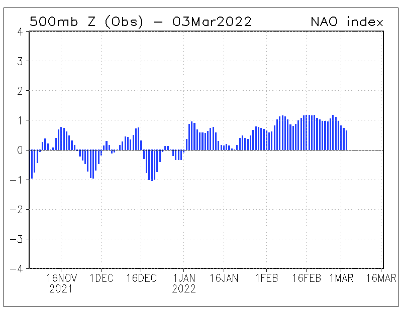
Circulation of the atmosphere ensures the absence of hurricanes in the eastern Atlantic.
In the Western Atlantic, tropical storms can form in the Caribbean.
https://www.tropicaltidbits.com/sat/satlooper.php?region=watl&product=wv-mid
I was gonna make a smart remark about St Greta’s sea-trip, but several have beaten me to it!
My metrics have this as the slowest start since 2014. The “C” storm that year formed on August 23.
New headline:
Slowest Start to Hurricane Scare Story Season in the History of the Climate Media Crusades
This must be fake news. “Everybody knows” that weather, climate, storm frequency and severity, iron-poor blood, chronic fatigue syndrome, insect plagues, insect extinctions, and all things awful are getting worse on a daily basis, it’s all our fault, and there’s no hope of escape. What if there’s another lull in North Atlantic hurricanes like the 11 years following Katrina? Doomsayers will have to conjure up another apocalypse. Yikes!
It’s so much easier to repeat the mantra, “Everything’s bad and getting worse. 12 years until doomsday. Flog the fossil fuel companies, or it’s over the cliff for all of us.”
Hi Allan
Please pass on this link to my radio interview with Tom Harris
Best, Madhav
http://thinkradio.ca/index.php/our-shows/exploratory-journeys-with-tom-harris/93-exploratory-journeys-episode-007
And just like that NOAA doubles down on stupid….
https://www.wral.com/noaa-now-predicts-above-normal-atlantic-hurricane-season/18557731/
https://www.googlesciencefair.com/projects/2018/171e50b2cff5898513e14907f2c63bbebafcd1827c2fb5bc575f3f1c0950a1b3– Th future looks bright
This pressure distribution in the North Atlantic is not favorable for hurricane development.
I realize this story is a few days old and has dropped off everyone’s radar, but I’m really curious. Could the dearth of energy coming off the west coast of Africa be related to the European heat wave(s)? It seems like the warm air that normally crosses the continent and hits the Atlantic was funneled northward instead. Is this a known phenomenon?
The heatwave was a weather event set up by the positioning of high and low pressure areas in combination with a certain jetstream configuration. Research ‘omega block’ for an explanation. That situation lasted less than a week, and the various elements have all changed.
The fact that is has a name shows that it occasionally happens. It was random chance that it all came together in the middle of summer, and funneled hot, African air into Europe. Any other time, any other place, and it would likely have been an unremarkable event.
Ay any rate, it is long gone and not affecting low pressure areas coming off the west coast of Africa.
Thank you jtom. That’s what I was looking for.