From a paper by the same title published in AGU’s journal “Water Resources Resarch” and also “Commentaries on Hydrology and Earth Surface” h/t to CTM
It is now well established that rising temperatures are increasing precipitation extremes. This has led many to believe that flood magnitude and hence risk are also increasing, while observational evidence suggests otherwise. This commentary outlines the reasons for this dichotomy and presents mechanisms that may be contributing to it. The implications of increasing precipitation extremes leading to reducing flood magnitudes are discussed, and an argument is made that understanding this changing link between the two is deserving of increased attention.
Abstract
Despite evidence of increasing precipitation extremes, corresponding evidence for increases in flooding remains elusive. If anything, flood magnitudes are decreasing despite widespread claims by the climate community that if precipitation extremes increase, floods must also. In this commentary we suggest reasons why increases in extreme rainfall are not resulting in corresponding increases in flooding. Among the possible mechanisms responsible, we identify decreases in antecedent soil moisture, decreasing storm extent, and decreases in snowmelt. We argue that understanding the link between changes in precipitation and changes in flooding is a grand challenge for the hydrologic community and is deserving of increased attention.
Summary:
There is a clear dichotomy between observed increases in precipitation extremes and the lack of corresponding increases in floods, with reduced flood magnitudes observed in many cases. Despite the conceptual arguments we’ve made, there remains a good deal of uncertainty in the relationships between changes in precipitation and flood magnitude across the spectrum of catchment, storm, and antecedent hydrologic conditions. Although changes in flood magnitude are unlikely to be explainable by precipitation changes alone, this has largely been the focus to date in the climate literature. Moving forward, along with a better characterization of changes in floods not directly driven by precipitation increases, we argue for a focus on the complexity of the relationships among the entire suite of variables (including precipitation extremes) that lead to the generation of flood extremes. In our view, the foremost among these are as follows:
- Changes to antecedent hydrologic conditions and their impact on flood response;
- Changes in the proportion and persistence of storms arising from different causative mechanisms, such as an increased proportion and frequency of convective extremes;
- Interaction among catchment size and geometry and changing storm characteristics including extent, intensity, and duration;
- Snow cover and snow volume changes and their changing contributions to flood extremes in a warmer climate;
- The role of land cover change (especially, but not only, urbanization) and the interaction of land cover change with climatic factors.
The full paper is open access at:
https://agupubs.onlinelibrary.wiley.com/doi/full/10.1029/2018WR023749
So, they start with a premise that is questionable, “evidence of increasing precipitation extremes”, tell floods aren’t increasing and then conclude, it’s complicated?
There is value in this ‘study’?
No. Their references use cherrypicked dates to establish a fake trend.
Once again, CAGW is built on nothing more than failed models and biased cherrypicks.
“Once again”, which dates are you saying are cherrypicked?
Which dates were picked, Loydo?
I think that they instead cherry-pick the statistics used to measure an “extreme” precipitation event to be something that is not all that extreme.
I just checked the references cited in the paper reviewed in the article, and it seems they defined an “extreme” precipitation event as the maximum daily rainfall amount that occurs in a given year. So, for example, here in Portland in a typical year we might get maximum daily precipitation event of about 1.5-2.5 inches of rain – nothing that by itself will be nearly enough to cause any kind of flooding. And in a desert environment, an extreme rainfall event might be a half-an-inch.
Now imagine how noisy that data is, when it takes a year in a given location to get a single data point, and the variance from one year to the next could may easily be higher than the average. The trend they claim is about 7%. Just how statistically significant do you suppose that is?
I remember that in one of Obama’s NAS climate assessments, they defined an “extreme” rainfall event as one in which more than 5% of whatever annual average rainfall was expected in a given year fell in one day. So if you expected 20 inches of rain in a year, a single inch counted as an “extreme” rainfall event.
Showing a small trend in these annual max rainfall events does not necessarily suggest that truly severe rainfall events are increasing.
The unholy trinity of untruth:
Lies, Damn Lies, and … Statistics.
Statistics are an attempt to provide meaning where there is none! STAT 101, UW, 1960
Updated to the new century, the phrase should read: “Lies, Damn Lies, Statistics, and Climate Science.”
Kurt, I think the Climate Science is already covered by “Damn Lies”.
When someone makes such silly statements as noted above, ……. then they are fairly free to make all sorts of silly statements about what they initially stated.
“DUH”, …… literally speaking, …… precipitation extremes or increases in precipitation extremes ….. does not cause flooding.
And it is also quite possible, or normal, whereby one could “observe increases in precipitation extremes” ……. while during the same period “observe reduced flood magnitudes”.
“DUH”, …… a month long “drizzling” rain of a total accumulated volume of 12” could be labeled a “precipitation extremes” but it sure as ell wouldn‘t cause any flooding.
Flooding only occurs when the precipitation rate/volume exceeds the “outflow” rate/volume of the river (stream/creek/etc) channel.
“If Precipitation Extremes Are Increasing, Why Aren’t Floods?”
Floods are reduced due to dams regulating water flows more evenly throughout the year. But where the worst flooding does hit is coincident with cities having paved over natural drainage and soil absorption, but you never hear about exactly what causes what anymore, only that somehow CO2 is just responsible for everything bad and if we could just kick that awful habit, then the weather and long term climate would just return to some blissful state.
Did the authors consider perhaps a good portion of the “antecedent hydrological conditions” are the growing thirsty population that are changing aquifer replenishment rates as well as land form?
“But where the worst flooding does hit is coincident with cities having paved over natural drainage and soil absorption, but”:
not fitting drainage to the new conditions.
A new airport paved for – but no fit for drainage:
https://www.google.com/search?q=berlin+u-bahn+flood+precipitation&oq=berlin+u-bahn+flood+precipitation&aqs=chrome.
Front gardens in British cities are being paved over to provide off-road parking or simply for easier maintenance. Back gardens too for the easier maintenance.
It is now well established ……… etc. Translation: that meme has now been repeated so often that we now really believe it.
From the “Plain Language Summary” of their paper:
…so they at least made the attempt. I did not attempt to deconstruct any of the five references to see if their “data” came from empirical sources or models.
The meme is based on the conjecture that the relative humidity remains the same when temperature rises or falls. There is no observational evidence at all that this is the case and there is no theoretical reason why that should be the case. It is one of those fundamental ingredients of how the atmosphere functions that nobody, nobody, really understands.
I get weather from Wunderground. You can add a “feels like” line to the graph. It usually tracks below the air temperature. Only occasionally does it go higher(saturated air).
thats funny.
you just rejected without looking.
armchair science.
Did you read it, Steven? I just did. I’ve never seen so many references to others’ papers in a piece of writing.
I see it was called an opinion piece rather than a true paper, but they had no data of their own to speak of. They made an assertion, then referenced a paper or four; another assertion, and another group of references.
The paper never even provided evidence for it main supporting theme, that extreme rainfall events were occurring with more frequency. It just listed more links.
An odd thing with the links, too: every one I clicked took me to this paper. I checked on my laptop to see if it was a phone thing, and got the same result.
WUWT???
Strangely enough, I do not hear about those millions of square feet (or square metres) of meadows and forest that became roofs, parking lots, roads, commercial centers, streets etc. Rains, even big ones used to be absorbed into the soil of what used to be fields, meadows and forest. They are now channeled into the waterways that were never intended to carry that much. Maybe once i a century, but every year. Dams are a dangerous and expensive substitute for absorbent soil.
+10
And those rivers have concrete banks or dikes ensuring the water stays channeled. The dam 100 miles up stream of the city I live in begins dumping water when a prediction like the heavy rains last month are predicted. Thus, reducing the water flow for a few days. We started getting a rise in river level days before it started raining due to this release. Replacing farmland with developments also means removing the fallen trees, shrubs and other natural blockages in the streams and tributaries around these developments hastening the water flow to the river.
” … expensive substitute for absorbent soil.” Let me fix that for you. Dams, stormwater drains and retention basins are the essential substitute for absorbent soil, if you don’t happen to have that feature, either because it is built over, or it never existed in the first place. This city region is 3,736 km2 in area. At least 80% of that is flat or very flat, and about 90% of the soil in the flat area is “old alluvial” eg heavy clay. Permeability rate is +/- 1 millimetre a day.
It’s not necessarily the absorption of the soil. Most flood occur after weeks of rain, so the soil is already saturated. The urban environment does make the runoff enter the streams faster, and so the peak of the flood occurs quicker and has a higher velocity, but for a shorter duration. This will cause localised flooding only.
Large catchment flooding is a different animal, and generally not influenced by urbanisation. The urban environment may be in the way of the flood, but the hard surface contributes bugger all to the total.
I do so love clarity in English: “extreme precipitation events (in a probabilistic sense)”
If they are awful at science it’s no surprise that they aren’t very good at English either.
From the article: “It is now well established that rising temperatures are increasing precipitation extremes.”
Is there any evidence for either one of these claims?
The temperatures are actually cooling right now, down about 0.6C since Feb 2016.
I can’t think of a single instance of extreme precipitation, more extreme than in the past, anyway, taking place in the last few decades other than those connected to hurricanes, and that heavy rainfall is determined by the speed the hurricane moves, with slow motion resulting in more rainfall over affected areas.
Temperatures are not currently rising, and there is no evidence for “increasing precipitation extremes”.
Science by assertion is what this is.
Facts, schmacts….
The Left accuses Conservatives of anti-science make up your own fact behavior, but the Left rampantly is actually the one that engage in anti-science and make up your own facts. Try this one piece of climate propaganda from USA Today:
https://www.usatoday.com/story/news/nation/2019/03/20/nebraska-floods-more-water-coming-heres-what-mankind-should-do/3214576002/
“The waters are rising, the floods are coming. What are we doing to save ourselves?”
(note the alarmist rhetoric title. Yes, what are we going to do to “save ourselves”?
The article’s writer starts out blaming “coming” floods on CC. But then goes back and uses history of flooding and how people and communities respond to it. Problem for this uncritically-thinking writer is she is in effect acknowledging that flooding has always occurred and it was more common in the past. She can’t see the stupidity of her original premise because her programmed bias is so high and the extreme cognitive dissonance would snap her liberal-brain.
So what has always happened before CO2-rise began be an additional forcing factor (pre-1950), the Stupid anti-science Left now blames on Climate Change, which by their own definition is a CO2-driven climate change. The stupid ignorant Left thinks everyone is stupid and gullible like themselves.
And to answer her original question, “What are we going to do about it?”
My answer is “Re-elect Trump”, and continue to ignore the non-problem of CO2 rise. Use the money not wasted solving a non-problem with even more useless wind turbines and solar panels, and invest it in real infrastructure improvements to counter weather events that have always happened.
“If Precipitation Extremes Are Increasing, Why Aren’t Floods?”
Because there’s big bucks in telling lies.
I would say it as, “There’s big bucks in selling lies.”
As I frequently written here at WUWT, the Left loves the Big Lie.
And the bigger the better, because there’s more to gain the bigger the lie.
Basically what Warren Buffett said. Insurance losses (and premiums) have not been affected by “climate change”, and aren’t projected to as far as he can tell.
“It is now well established that Big Foot herds are increasing in size. This has led many to believe that we should be experiencing even more Big Foot sightings and even photographs and videos. Despite evidence of increasing Big Foot herd sizes, corresponding evidence for increases in sightings and photographs remains elusive. ”
Hey, look! I just did science!
Love your science
When “extreme” is defined by (unstated) minuscule statistical terms, the word is meant to alarm the reader, not inform. Show me the data!
The five variables listed as affecting flooding are indicative of the complexity of the problem. The paper seems to use such complexity in an attempt to say “Yes, there is no increase in flooding, but just wait, it will come in the future. Our CliSci brethren say so.”
I wonder where they got the data indicating “… decreases in snowmelt.”? Likewise “…an increased proportion and frequency of convective extremes;”
“It is now well established that rising temperatures are increasing precipitation extremes.”
It is? What precipitation extremes are you referring to? I have seen nothing but normal variations in weather. Please define what you mean by “Extreme”.
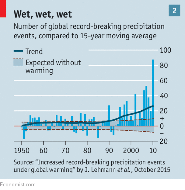
“Why, on average, rainfall extremes are increasing (and are expected to continue increasing) can be summarized by a simple conceptualization. If temperature increases, in accordance with the Clausius‐Clapeyron relationship, so does the saturation vapor pressure of the atmosphere, at a rate of approximately 7% per degree centigrade”
Or…we are entering a natural “wet” cycle likely caused by ocean temperature oscillations. Again, what extremes??? I looked at your map (https://www.researchgate.net/figure/HadEX2-observational-data-versus-CMIP5-averaged-results-of-global-extreme-precipitation_fig3_272352548) and its funny how the places that warmed the most (North) saw the least change in precipitation. Oops!
“The result is that the atmosphere is able to hold more moisture, and, if there is more moisture in the atmosphere, then in an extreme event, more precipitation results. ”
And…more heat transfer from the surface air layer to upper atmosphere takes place cooling down the surface air. The more clouds, the less sunshine warming the Earth. Funny how a natural system with negative feedbacks is so stable… Too bad your models are not.
Face it, your models are WRONG.
In skimming through the AGU paper, it is obvious that everything depends on UN IPCC climate models predicting significant future temperature increases. Beware AR6 models.
The primary assumption is faulty. “If temperature increases, in accordance with the Clausius‐Clapeyron relationship, so does the saturation vapor pressure of the atmosphere….”
The C-C equation is an equilibrium state equation. The atmosphere is never at equilibrium so an exact meaning of how C-C applies is unclear. A good example is dew. It forms when the air temperature drops after sunset. This causes water to condense. Heat is released and the formerly saturated air tends to rise. Sun hits the dew in the morning and it evaporates. For additional water to evaporate addition heat has to come from somewhere.
Eventually the cloud cycle starts and a thunderstorm might form, releasing all the extra heat as wind, rain, and cooler air.
None of the sub-grid atmosphere can be modeled with any of the climate models. The paper is simply off base to use the C-C as a state equation to say the atmosphere becomes more humid. It may, or may not, depending on the weather.
Did a Google search out of interest and there seems to be plenty of evidence of both increased precipitation and also flooding events worldwide ……
https://phys.org/news/2018-09-frequency-world-largest-river-fivefold.html


https://www.epa.gov/climate-indicators/climate-change-indicators-heavy-precipitation
“Total insurance losses for storms and hydrological events including floods have increased over the past two decades, as shown in the modelling by The Economist below. But these figures are only measuring the insurance payouts; additional losses by public and private entities are not covered by insurance.”
https://www.cicero.oslo.no/en/posts/climate-news/no-investor-is-safe-from-extreme-weather
https://www.cicero.oslo.no/file/crop/ab43994bad0da7164de5ac24bdf826aa
Check the cherrypicked dates, and get back to me.
“Insurance losses from storms and floods have increased…” Looking at dollar amounts to somehow measure storm frequency and intensity is ridiculous, as obviously things cost more now and there’s more people and structures in the way.
So when you left your meteorologist position with the UKMO, were you replaced by an insurance adjuster?
I thought CO2 caused fires and droughts? Now magical CO2 causes extreme precipitation without droughts…I am extremely impressed. I wonder what happens if I were to sprinkle CO2 on my steak?
Don’t forget, increasing CO2 will make asteroid strikes more likely, too.
I know what happens when solid CO2 is dropped in a glass of liquid water.
So sprinkling dry-ice on a steak, well that would just make the steak cold. You certainly would want to wait for the all the dry-ice to sublimate away. Cold steak, no good. Best eaten right off the grill.
(And not to be confused with the medical horror of swallowing a glass of liquid N2. It’s been done, very very bad.)
You tube videos prove that in order to negate the awful effects of drinking liquid nitrogen, you must first eat as many Tide pods as you can fit in your mouth.
If you put CO2 on your steak, you will lose weight, gain weight, love your food, hate your food, be able to afford more of it, be able to afford less of it, live longer, live for less long, have a heart attack, not have a heart attack, get cancer easier, not get cancer, get a divorce, stay married, have successful children, have children that are complete failures, and everything else you can think of. As long as it is bad.
Caveat: If any of the above things are a net positive, then they will NOT happen. Unless you want them too, in which case they will.
See how it works?
BTW,if any of what I wrote in the above comment made any sense whatsoever, I must have said it wrong.
It is not clear at all that precipitation extremes are getting more, well, extreme.
What is clear is that modern technology and vast expansions in weather monitoring data collection make it much easier to collect extreme precipitation data.
If precipitation events were indeed more extreme, then it is obvious that flooding events would be getting more extreme. They aren’t, therefore they aren’t.
Flooding should be on the rise due urbanization even if precipitation didn’t change one bit. If flooding isn’t increasing, precipitation/extreme rainfall sure isn’t.
Accept the following for Australia only. All urban storm water systems are designed for a 10 year event and the 100 year event. The 10 year event must be trafficable for vehicles and pedestrians. And the 100 year event must not encroach into private property, which means overland flow paths and easements.
These are new rules, so the older areas (20 years plus) were most probably designed for the 5 year event only.
There is very little difference between the 10 year and 20 year event. You couldn’t tell just by looking at the rain, or the flow in the roadway.
I don’t know what they’re calling extreme, but I know all new highway bridges are designed for the 1000 year event or better.
So in conclusion, I’m not surprised you haven’t noticed any increase. They are rare events to begin with, and design for them anyway.
Depends upon the jurisdiction.
In advanced nations where development standards are strictly enforced, stormwater runoff in excess of natural undeveloped conditions must be managed to prevent flooding, typically by using stormwater retention or detention ponds, either onsite, or ponds that service larger areas. The return period for the design allowable storm determines the capacity of the stormwater management feature, and usually is a function of what is being protected.
Greg discusses the Australian standard. Here in the US it varies somewhat by individual states, but generally roadway runoff features (gutters) are designed to handle the 10 year event (as further defined by storm duration, i.e., the one-hour or 24 hour duration storm), while community stormwater retention ponds are sized for the 25 year or 100 year event. Major regional stormwater management features like levies or dam spillways are sized to handle larger events up to the PMF (probable maximum flood, which is usually not much higher than the 500 year event).
The intent of these rules is to mitigate the increased runoff that results from impervious surface development. But as we saw in New Orleans in 2005, just because a system is designed to function at a particular performance level does not mean that it has been constructed and operated fully in accordance with the requirements, and sometimes these systems fail at the worst possible time. That was essentially what happened to N.O. during Hurricane Katrina. The storm surged wasn’t really all that strong in New Orleans, which was well to the west of where the eye made landfall in Mississippi .. but the city’s stormwater management system turned out to be very defective.
“Despite evidence of increasing energy bill extremes, corresponding increases in energy consumption remain elusive”.
Can’t say I even bothered to read this article. Confusing confusion is not my scene.
Precipitation is connected to runoff by regional calibration of the watershed. Has the rainfall-runoff conversion method changed in the data sets, or are different methods used in different data sets? Has a flood-prone area constructed flood protection so that it is not flooded as often even though precipitation or watershed runoff has increased? One of the hydrologic methods is Curve Number Hydrology. Curve Numbers are related to soil or cover conditions in Groups A, B, C, or D and antecedent moisture conditions (AMC I, II, III). All this has been fundamentally changed (where have we heard that before?) by a 2009 publication “Curve Number Hydrology – State of the Practice”.
https://ascelibrary.org/doi/book/10.1061/9780784410042
Two changes of note. Antecedent moisture condition (AMC) is now antecedent runoff condition (ARC). Soil Group D with highest runoff potential is now listed as having an even higher runoff potential.
Thought for the day from C.T. Haan “Statistical Methods in Hydrology”: “The concept of a P[robable] M[aximum] F[ood] has been criticized (Yevjevich 1968) as being neither probable nor maximum, yet it has found wide use for hydrologic designs for facilities whose failure would endanger human life or cause great economic loss.”
Curve number hydrology is hokey as hell.
Yes. A branch of Voodoo Hydrology. For example in a certain urban watershed, the measured 25-year precipitation event (4% annual chance exceedence) produced the measured 100-year runoff event (1% ACE). And don’t forget regional regression equations. And “high outliers”. They really happened. Why wouldn’t you consider them in your flow frequency calculations instead of putting them into the memory hole? The last would be a rhetorical question except that it happened. You can search for “Alluvial Amnesia” and get a link to a PDF download:
Organization of The Report 52 the Center for Governmental Studies
[Search domain research.policyarchive.org/220.pdf] research.policyarchive.org/220.pdf
ALLUVIAL AMNESIA ii SUMMARY This report reveals how two recently opened public schools in Rancho Cucamonga were built in a floodplain despite warnings from state emergency managers that flood evacuation plans were not in place and that the entire area was potentially subject to flooding.
Is a drought an extreme precipitation event?
We all have a tendency to find what we are looking for, and to overlook facts and evidence that we’re not looking for – especially if what we’re not looking for seems to have no connection or impact on what we’re trying to find or prove.
This would seem to be an example of that, as well as putting the cart before the horse. Let’s invent a hypothesis and then go look for stuff to support it! And ignore everything else…
I love the phrase “” It is now well established””.
One could of course just as well say that “” It is now well established that
the Green movement is just a cover for a future World Government, i.e.
Communism.””.
Regarding flooding, well if councils plus developers build on what is clearly
marked on the maps as a flood plain, two things must be done. Either
Queensland style build all your houses on high supports, or dig deep
channels to carry the water away.
Dams of course, they serve two main functions, decreasing the chances of
flooding, plus a much needed source of water. Possibly some very green
electricity generation too.
As too the increasing temperature, who says. Prove it.
MJE VK5ELL
It is now well established (by repeated example) that climate activists repeat “It is now well established” whenever they cannot find any well established evidence that confirms their claims of climate catastrophe.
Whenever you hear “it is now well established” uttered by a climate activist you can be assured “it” has not been established at all.
SR
If they really believe precipitation is increasing shouldn’t they be telling us to build lots of arks or did I miss something – it is so difficult not to nod off reading yet another “the sky is falling” terror alert from the alarmist claptrappia.
There is a real time example of how increased rain/snow may not lead to increased flood dangers right where I live. Earlier I had left a reply which is directly related to this post. Here is that comment “That was a good rain/snow winter, well above average. The snow melted early though. It was gone by the end of February, because of the continued warm conditions. So this winter/spring is a notable change from the last 9 years. For example in spring of 2015 and 2016 the snow was gone by the middle of January. That was exceptionally early. ….”.
So all of that snow which is now sitting atop the mountain ridges through out Trinity County is water which has been tied up. The Trinity Alps used to have glaciers until this last round of global warming of the last several decades. There is a good chance that this year will mark the first year of some portion of the snow pack remaining into the next winter season. If this is happening in other mountain areas of the northwest and elsewhere around the globe, then that is water content getting taken out of the global system until such a time as conditions change. If the climate does maintain a cooler trend into the mid 2030s, then water will continue to be locked up in the form of growing glaciers.
The Trinity Alps is over 160% of average on its snow pack this year.
Given the vast difference in volumetric heat capacity between air and water that is water at the same temperature contains about 3000X more heat then dry air, how is it possible that small increases in air temperature i.e. 1 C can heat water to increase its vapor pressure?
A cubic meter of seawater has a density 800 times greater than the cubic meter of atmosphere in contact with the surface. The specific heat of seawater is 4 times greater than the atmosphere.
800 x 4 is equal to 3200.
That ratio means that the seawater will require 3200 Joules of energy to increase temperature of the seawater by the same amount that the air above with 1 Joule.
(The actual specific heat of the air is 1 kilojoule per kilogram for 1 Kelvin)
Any externally added joules to the air/seawater interface will then exchange into the seawater by that ratio.
It is now well established that every single word uttered or written by a government funded climate scientist is complete malarkey that will be quickly debunked many times over, hence it is safe to not only ignore it, but ridicule, scoff, and make fun of it.
Most rain gauges monitored by the National Weather Service, at least the usual automated ones at airports, were changed in/around 2003 from a tipping bucket type to the more accurate AWPAG. Tipping bucket rain gauges read low in heavy rain. There is a correction algorithm, but it is cumbersome for unsteady heavy rain, and I don’t know how much and how well it is used.
The plot thickens! 🙂
It is now well established that rising levels of climate indoctrination are increasing hysterical outbursts and behavioural extremes by activists. This has led many to believe that bad weather and hence risk are also increasing, while observational evidence suggests otherwise.
Here are three centuries of precipitation records for Paris, from 1680 to 2001 (with a large gap in the 18th century)
https://agupubs.onlinelibrary.wiley.com/doi/full/10.1029/2001GL014302
There is a slight upward linear trend in the data, varying by season, up to 10% per century. The plot is mostly cyclic, rolling hills and valleys, with occasional extreme spike every half century or so.
The article was keen on pointing out that the year 2000 was a very wet year
Where I live, inland south-eastern Australia, precipitation extremes are increasing, but at the lower end – rainfall from 1 Jan – 21 Apr 2019: 9mm, and the Darling River (Australia’s second biggest) is dry. So here the precipitation extreme is definitely reducing flooding.
On the other hand, in northern Australia…https://en.wikipedia.org/wiki/2019_Townsville_flood.
I think you’re making an unwarranted statement. There is no evidence that increased precipitation extremes — if they are increasing — is reducing flooding; it’s just not causing INCREASED flooding.
There’s a big difference in those two statements.
My comment was motivated by the post and comments talk about precipitation extremes (plural) but then only consider one extreme – higher precipitation.
I stand by my comment that extreme decreases in rainfall, resulting in longer droughts, reduces the amount of flooding. That’s different from ‘not causing increased flooding’. There are circumstances where flooding is valuable – to water and replenish floodplain.
There was a big burst of quake activity on the West Coast today, including a moderate quake up by Port Hardy Canada, after a lull for several days. The Phillippines had a strong quake as well. … https://earthquake.usgs.gov/earthquakes/map/#%7B%22autoUpdate%22%3A%5B%22autoUpdate%22%5D%2C%22basemap%22%3A%22satellite%22%2C%22feed%22%3A%221day_m25%22%2C%22listFormat%22%3A%22default%22%2C%22mapposition%22%3A%5B%5B-82.89698689394206%2C-5.9765625%5D%2C%5B82.85338229176081%2C408.1640625%5D%5D%2C%22overlays%22%3A%5B%22plates%22%5D%2C%22restrictListToMap%22%3A%5B%22restrictListToMap%22%5D%2C%22search%22%3Anull%2C%22sort%22%3A%22newest%22%2C%22timezone%22%3A%22utc%22%2C%22viewModes%22%3A%5B%22list%22%2C%22map%22%5D%2C%22event%22%3Anull%7D
UK floods have increased since 2000…
somewhere like Carlisle/Cumbria has had repeated 1 in 100 year record floods (exceeding twice the previous early 1800s record). The second set of floods went over the flood defences designed to cope with another outbreak like the first…
The UK has seen record new rainfall levels from slow moving depressions and indeed an increase in damaging storms and tidal surges.
It may not be evident in the USA, but the UK climate has certainly changed.
Please do try and make sense Ms Griff. Are the floods increasing since 2000, or since the early 1800’s? Clearly you have no real clue, and you are only here to make wild unsubstantiated claims to keep funding pseudoscience instead of feeding poor brown people. You never have told me why you hate poor brown people so very much.
The comment seems quite clear, that the post 2000 floods have been bigger that the previous floods, including the previous 1800s record high. The following gives some un-wild substantiation, easy to find on-line. There’s no doubt a final report available.
Carlisle Flood Investigation Report Final Draft – Cumbria
https://www.cumbria.gov.uk/eLibrary/Content/Internet/536/6181/… · PDF file
The city has a long history of flooding with notable floods in 1771, 1822, 1856, 1925, 1968 and more recently in 2005. The 2015 flood level on the River Eden was 0.6m higher than in..
No pseudoscience, just data. Even if you disagree with it, there’s no need to be uncivil.
So alarmism is civil? Even when it results in millions of starved children? I never knew. Silly me.
It helps to recognize that there are many different kinds of flooding.
The IPCC’s special report on extreme weather claimed that short periods of intense rainfall had become more common. This is the kind of rainfall that produces flash floods.
Other floods are caused by weather fronts that remain stationary to an unusually long period of time. This is sometimes called blocking, and causes day after day of rainfall in one particular region.
For somewhat similar reasons, Hurricane Harvey stalled over Houston and produced extraordinary flooding.
Another reason for flooding is a sudden melting of accumulated winter snow.
In some locations, flooding is caused by “atmospheric rivers” delivering a large amount of moisture from the tropics to temperate zones.
Although intense rainfall has become modestly more frequent (as predicted), none of the other causes of flooding has been observed OR predicted to increase.
The biggest reason for changes in flooding is man: We dammed rivers, built levees along long stretches of rivers, and shaped then in many other ways. Man contributes in some way to all modern flooding, but usually not through burning fossil fuels.
We changed the way we measured precipitation – in the past rain gauges could not measure large rainfall nor measure the rate of fall in short cloudbursts. We can now. I think the supposed “change” is purely down to instrumentation changes.