by Rud Istvan,
ctm and I were having lunch recently near our mutually admired South Florida coral reef system, and over conversation we started speculating about ARGO. I brought up Jason2 SLR as an analog. WUWT readers can see my 2016 WUWT guest post: ‘Sea Level Rise, Acceleration, and Closure’ for details. That ctm lunch has inspired a lot more volunteer WUWT ‘sciency’ research on whether the most modern climate research instrument systems are fit for purpose. This post covers satellite altimetry measured sea level rise (SLR). The short answer is NOPE. The eventual companion post whose results are TBD,because ‘It’s complicated, folks’, and will cover ARGO. Dunno any ARGO answer(s) yet.
There are strong evidentiary reasons to think satellite altimetry does NOT accurately represent SLR change over time. The two most irrefutable observational reasons are:
(1) Satellite altimetry measured trends are about 1.5x higher than differential GPS, (vertical land motion) corrected long record tide gauges (about 3.4 versus about 2.2 mm/yr)
(2) the dGPS tide gauge estimates roughly close, while Jason2 satellite altimetry estimates definitely do NOT. Per my previous above referenced guest post, ‘closure’ is the simple arithmetic that SLR must approximately equal thermosteric rise, as hotter seawater expands in volume, plus ice sheet losses (land based ice when melted adds ocean water), while all other contributions, such as ground water extraction are arguably de minimus.)
So, is the most recent ‘satalt bird’, Jason3, fit for purpose? Satellite altimetry uses radar signal returns reflected off a wavy ocean surface to estimate sea level from the timing of the signal from generation to receipt. This is no different in principle than any other range estimating radar system. And as many military and commercial aviation uses evidence, radar ranging generally IS fit for purpose.
Except, military cruise missile ranging is meters between Syrian aircraft bunkers, not millimeters. Commercial aviation aircraft avoidance is kilometers between planes, not millimeters. But sea level changes are measured in millimeters/yr. That is a different accuracy/precision ball game, and the logical essence of this post.
Rather than a bunch of footnotes and links necessary for ‘whack-a-mole’ guest posts like my recent ‘Antarctic SLR contributions’, this guest post simply extracts irrefutable images and numeric values from the official Jason3, (the newest satalt bird) NASA reference products and mission specs. The official ‘product’ documents are available at podacc.jpl.nasa.gov/Jason3 for any WUWT reader wanting to double check. The related Jason3 mission/physical instrument specs are available at ospo.noaa.gov. This guest post uses Jason3 product handbook version 1.5, issued 9/17/18.
Jason3 was launched into polar orbit on 1/17/2016.

It overlaps Jason2, and interestingly shows significantly less SLR in its overlap period. According to NASA, Jason3 instruments and processing algorithms correct for ‘known’, (and noted in my Blowing Smoke ebook SLR essay ‘PseudoPrecision’) Jason2 deficiencies: wave height, sigma naught, tropospheric, and ionospheric humidity. Jason3’s many new instruments now have a spatial aperture ‘pixel’ resolution of 11.2km x 5.1km, allowing closer calibration to land altitude reference pixels in order to better estimate temporal orbital decay.
The following schematic from the official Jason3 NASA information illustrates only some of the data processing problems Jason3 supposedly now ‘overcomes’.

The smaller Jason3 aperture improves its reference orbital accuracy. True. But probably not the processing algorithms for the reference Earth ellipsoid; thanks to geology Earth’s gravity field is anything but a uniform reference ellipsoid. GRACE gravimetric data shows it is a lumpy mess; which means that even though water seeks its own level, ocean seawater is NOT level across a lumpy planetary gravity field.

So, what does the latest NASA information say about Jason3’s algorithmically processed radar return data? Jason3 product manual §1.4.4 says all distance units are reported in units of 1/10 millimeter. WOW! Sure sounds fit for purpose!?!
Not quite. Following is NASA Jason3 ‘product’ manual Table 2.3.1.

For those that are NASA table challenged, the key number is IGDR actual for Total Sea Surface Height hHeightHeighight RMS, (Listed as RSS in the table above is, as noted on the associated EU Jason3 site [it’s a joint mission], just a NASA typo) precision of 3.3 cm. Not mm! This is still an improvement over Jason2, which had an SLR RMS pixel precision of 3.4 cm.
This is defined by repeated pass aperture over the same site ‘pixel’ on the lumpy Earth ellipsoid. I know of no statistics that can reduce a minimum repeatable precision error of >3 cm to an ‘average accuracy’ of 0.1 mm without a ginormous error bar, which NASA ‘conveniently’ DOES NOT provide.
An error term digression is perhaps useful for those who are not long time WUWT readers or Judith Curry “uncertainty monster” cognoscenti. There are two basic error types: precision and accuracy. The simplest layman’s explanation is from target shooting. A tight group is precision. A group on the bullseye is accuracy. An easily understood general illustration is:

NASA Jason3 information say it has BOTH precision and accuracy problems. Its ‘grouping’ precision is 3.3 cm, deceitfully reported to 0.1mm. Its accuracy is 1.5x high off what dGPS corrected long record tide gauges report. For climate purposes it is in quadrants 1/2 rather than 3/4. NOT good.
One further not-so-little satalt factoid. The Jason3 instrument drift spec (column GDR goal, last line) is identical to Jason2, ≤ 1mm/year. So the SLR acceleration that Jason2 ‘sees’ that Jason3 does not (yet) is likely just ‘in spec’ instrument drift between the two.
Ineluctable conclusion: current satellite altimetry measurements of SLR are NOT fit for climate purpose.
I have always wondered how multiple measurements of things with a low degree of precision (be it temperature or sea level) can be miraculously transformed into a high resolution, high precision number . Looks like it can’t unless you practice Mannomatic (TM) mathematics.
The trouble is that it works under the right circumstances.
I used to do a numerical experiment with my students. A small sine wave of known frequency was buried under noise that was a hundred times as powerful. A comparator was applied to the result. If the instantaneous value of signal plus noise voltage was above zero, a one was output. Otherwise, a minus one was output. The precision was, therefore, one bit.
Using a process not much more sophisticated than averaging, the original signal was recovered precision and accuracy depending on how many cycles worth of data was collected.
Similar techniques are used in your cell phone and they work great.
I totally see why scientists trust the process. It works in theory and sometimes in practice.
The trouble is that one of the criteria is that the noise is truly random. The noise you get from mother nature is usually red noise. Low frequencies predominate and the result is something that looks like a slow unpredictable drift. You can’t get rid of that by averaging.
In the face of red noise, the way you can get what looks like amazing precision and accuracy is to make some unfounded assumptions.
I’m pretty sure I see where they’re coming from and I’m pretty sure they’re wrong.
Using a process not much more sophisticated than averaging, the original signal was recovered with precision and accuracy depending on how many cycles worth of data was collected.
Yes Bob, you can do that if you are doing multiple measurements of the same thing. However, here they are measuring sea level at a variety of places at different times and in different conditions. The orbits precess so each revolution sees a different view. The aperture appears to be about 60sq km if I read Rud’s report right and that is being reduced to one number. They are measuring noise, not even certain if there is an underlying signal there.
They probably aren’t as good as they claim. On the other hand, they are a lot better than you give them credit for. Consider the accuracy of your GPS for instance.
The comment above refers to survey grade receivers. The thing with surveying is that the work is checked using non-GPS methods. That means the claimed accuracy is credible.
In many ways, the radar problem is simpler than the GPS problem. They’re not just measuring noise. On the other hand, as Rud points out above, the radar altimetry results disagree with other available data. That means the claimed accuracy is not credible.
Defining a small value buried in a large noise signal requires much more than that the noise be “truly random”. It must also be “stationary” and “ergodic”. The latter terms basically define that the statistical properties of the noise (mean, variance, and more ) cannot change over time. The dilemma, of course, is that the warmists are trying to prove that sea level properties ARE changing over time, i.e., the mean sea level is accelerating in its upward trend, and the variance is increasing (becoming “more severe”). Defining a small signal that is neither random, nor stationary, nor ergodic, that is buried in a large noise that MUST BE random and stationary and ergodic is a stretch.
Bob, don’t forget that the survey instrument is sitting in a fixed position on (relatively) solid ground for as long as you need it to be there. Almost every point on the surface of the ocean changes altitude, either up or down, by 10’s of centimetres every few seconds – and 2 points just a few metres apart are often moving in opposite directions compared to each other.
satellite sea-level estimations should be trusted to no more than 0.5 metre resolution. The resources devoted to their production are a waste of many millions of taxpayers dollars, which would be better spent fixing up roads or building more public transport.
If you actually read the Jason 3 details there is a similar trick involved as what you are doing with you students … the hint is there is a model involved which is what they resolve the readings against. People are just lazy and just assume things.
Now on a sidebar teh interesting difference between jason 1, jason 2 and jason 3 is how they treat waves. That is interesting since currently jason 3 is showing something very very interesting … hint look at the rate of increase.
Bob,
I have to disagree with you on one point: you can’t improve the accuracy by any kind of post processing. In your example you are limited by the accuracy of the comparator; even if you remove all of the (presumably gaussian) noise, the reconstructed signal will not be exactly the same as the original. This is a very important point that is often overlooked.
Two Linear Econometrists were deer hunting. One, the hunter, had the rifle, the other was spotting with binoculars. Lo and behold they saw a nice buck on a hillside quite some distance away. The hunter aimed and fired, kicking up dust three feet to the right of the buck, but with good elevation. “Three feet right!” exclaimed the spotter. The hunter compensated and fired again. This time the dust kicked up three feet to the left of the buck. “Got him!” exclaimed the spotter.
The bullseye example here is not an accurate presentation of these terms. The upper left, while not being precise is still very accurate since all the shots center on the bullseye. The first question on this page can be expanded to provide a better example of the use of this analogy. http://chemrightlabs.com/questions.html
They are not close to the center. Hence inaccurate.
If you look at the average, they are accurate, as the average distance from the center appears very small. Look at the link he provided. To be proper, the entire group should be shifted off to one side.
DJH, Yup. You are correct. But I was too lazy to make up my own variant illustration for this post, and that was the simplest I could find and legally grab.
Terrific that WUWT has a tough demanding readership. Strengthens the end output.
5 out of 7 are at or below the center and 5 out of 7 are left of center. Therefore, it’s inaccurate, a democrat shot or both.
Yup, just noticed that. Low left accuracy. So grabbed graphic is ‘correct’.
Proving again WUWT readers are fiercely scientific.
It depends on what you mean by accurate. To find the centroid of the shot group relative to the center of the bulls-eye, add all the x distances and divide by the number of shots (7). Repeat for the y distances. I printed out the image and used a grid where the bulls-eye has a radius of 1.5 units. To the nearest 0.5 grid distance, I get the following for x: (-.05), 4.5, (-4.5), (-1.0), 5.5, (-4.5), and (-0.5), working more or less top to bottom. The sum is (-1.0) and the centroid’s x coordinate is (-1/7) or (-0.14). Repeating for y: 4.5, 1.5, 0.5, (-1.0), (-2.5), (-4.5), and (-5.5). The sum is (-7.0) and the centroid’s y coordinate is (-7/7) or -(1.0). That puts the centroid of the upper left group in the bulls-eye. The total area of the bulls-eye is 4% of the total target area (R=1.5 units vs R=7.5 units). I’d say that’s pretty accurate. YMMV.
Plus, with the bullseye, it is obvious where the shots were aimed, which is analogous to knowing the reference value of a measured thing, also known as the accepted value.
But with sea level, there is no way to know what the actual, known-only-to-God number is.
In the bullseye analogy, sea level is like having a sheet of paper with no markings on it, and which is way larger than the grouping. We can easily see that the bullet holes in the first example are grouped more or less around the bullseye (but not evenly distributed around it) and they all hit the target.
No such reference exists for sea level, or for temperatures, in any particular spot at any particular time on any particular day. Previous disagreements amongst various commenters have often been regarding, in this analogy, whether it is possible to say whether lots more bullets might tell us what exact spot the shooter was aiming at on a large blank sheet of paper. IOW…what is the actual, known-only-to-God value.
Unless we take fixed devices anchored to a particular spot as correct (although I think there is a very good case to be made that those numbers are problematic as well, for several reasons, not the least of which is that 40 years ago the times series plots of global sea level were not monotonic, as id now the case). In which case, what are the satellites even for?
DJ,
Did you measure to the center of each hole? Looks like the results are rounded to the nearest 0.5 units. Consider the size of the hole in relation to the distances involved: It is a substantial fraction thereof. Between the rounding and the issue of the hole size and that different people with different rulers might easily take a different spot on each hole as the measured value, and we start to see how we need to take many measurements and a more finely divided ruler to state what confidence interval is.
This is exactly the sort of measurement that repeating it many times can tell us something about the precision and accuracy that one measurement cannot: Measuring the same thing over and over to smooth out the above mentioned errors.
Suppose we repeat the measurements many times, but with a different target with different holes each time? Can we say we have narrowed anything down?
On a 12 inch target (moose) top left and lower are not pretty shooting but like lower right will fill your freezer. Upper right probably not so much.
You can’t average bad shots into “accuracy.” As you can’t average POS GCM results into actual climate forecasting.
Accuracy in shooting is measured by how far from the point of aim the shot hit.
“The upper left, while not being precise is still very accurate since all the shots center on the bullseye.”
This is just silly. You’ll never win a Bullseye 2700 match with your shots scattered over targets, but “centered.”
DJH, when it comes to marksmanship, I think the ability to actually hit the bullseye, or kill your quarry, is more important than the averaged centre of all your shots, as the joke about the econometrists above exemplifies.
I appreciate that, but you and Gamecock are taking the analogy a little too literally. The discussion is about a population of measurements where the average has real meaning. In a rifle match, each shot is its own experiment with a population of one. If the center of the bulls-eye was the average height of males in my hometown, or the average weight of apples in the produce section of the local supermarket then the concept has real utility. Don’t mistake the map for the terrain.
The aim (or shot on average) is low, below the bullseye.
Not by much. See my comment above.
OFF TOPIC (slightly):
Without taking sides in this semantic discussion, this brings back fond memories of my teen through college years as a competitive rifle (.22) shooter.
Targets differed whether International (meter distances) or NRA (feet/yards) but most had a “sighting” bullseye. One would fire 2 or three (or more depending on your ability) shots to establish a “group” to see where you were with respect to sight adjustment and wind conditions (these were .22s at 50 to 100 yards/meters afterall). This would be the “precision” example.
You would then compensate with vertical and horizontal sight adjustments toward the X ring to gain what is referred here to as accuracy (what counted with the judges).
To brag on my teammates, 3 went on to US military academies; one a nuclear sub Commander and another after brief military service went into the diplomatic service eventually being a Secretary to the UN disarmament talks (primarily with NK).
Me? I had my memories :).
Similar memories, from a former captain of my high school and college rifle teams. A36 International targets, .22 cal, 50 feet. I used to say shooting was one of only 2 sports that can be done lying down on dry land, and the University wouldn’t hand out letter sweaters for the other one.
This has bothered me for quite a while; I have never seen mention of Earth Tides in any discussions of SLR. The “Lumpy Earth” picture is classic, now think of that as a viscous fluid of varying viscosities and try to figure out how much the swath of the earth under the satellite has moved at the instant of “ping’ as a result of tidal effect. Earth Tide can move the ground by up to a meter, that’s three orders of magnitude bigger than the SLR they are claiming to measure. What am I missing?
There are also 18 year lunar cycles yo consider.
… and don’t forget the small effect of the sun as well …
And the Trade Winds.
And how are the satellites compensating for the sea tides? There vary enormously over what are often short distances. The Bay of Fundy has a diurnal tidal range of 55 feet at one spot, but 56 feet at another.
Down in the Florida Keys (and a few other spots on the globe), the tidal range is inches per day on some days. I was camping at a place just East of the Seven mile bridge (Knights Key) one year and that water barely moved at all over a period of several days…good thing, because the camp sites were not more than a foot or two above the water.
Twenty miles away the tidal range was far greater. How in the world is all of that taken account of?
https://fl.usharbors.com/monthly-tides/Florida-Middle%20Keys/Knight%20Key%20Channel
https://fl.usharbors.com/monthly-tides/Florida-Lower%20Keys/Key%20Lois,%20southeast%20end
Dontcha know? Models!! /sarc
If you work in the Persian Gulf, one place along the Saudi coast its diurnal tides and a few hours up the coast is semi-diurnal tides. Prediction/modeling does not work in these waters, only local tide gauge installation.
Try predicting tides in Alaska.
Camped on Knights key campground some 20 years ago. I did not measure the tides, but guess the water level is about the same.
Mac
The moon’s pull will also impact the orbit of the satellite, and in the same direction. I suspect the lifting of the ocean and the lifting of the satellite will come pretty close to cancelling out.
The tides are readable in piezometers measuring depths to watertable in wells because of earth tides. The pull of the moon causes an increase in porosity of the aquifer (a ‘dilation’of the reservoir) and the water level drops as the earth bulges upwards. The amount can be as much as ~ half a foot.
I have given you this before and others have stated above you can measure this stuff and it’s actually done in the hard science.
http://www.slac.stanford.edu/econf/C0802113/papers/001.pdf
Not to ignore the rest of a fantasticpost, I was most intrigued by the fact that there are two of you hangingout together somewhere in South Florida…that makes thre of us 😉
Meetup anyone?
Lets do. I am on the beach in north Fort Lauderdale since 18 years. ctm is on the beach in south Pompano since about 1 year. I will buy lunch. ctm has the IT tools to organize it.
Oh that’s how! I was scratching my head over ctm in S. Florida, last I heard he was in California. Well, I hadn’t heard the last of it.
email sent
Heck, I’m in Ottawa, Canada in -18C, a lunch in Ft Lauderdale sounds awfully nice!
Gary, you are in … But I only buy the lunch.
The definitive norm of climate science seems to be doing too much with too little.
Claiming to measure something to .1mm with a tool that has 3.4 cm resolution seems like an exercise in magic.
Just like measuring “global” temps to 0.01C. It is a bad joke based on measurements, and even worse if made “right” by a bunch of algorithms.
See figure 1.
Now change the referenced (elipsoid) datum.
Now reconcile the old measured data.
Now change the referenced datum again.
Now reconcile the data.
Now talk about the precision (or magic).
Pick up any gun magazine and look at any gun review. They will have a chart for ‘accuracy.’ It will be group size. Uhh . . . duh . . . that is precision, not accuracy.
And even with bad precision, they will extol the accuracy of the gun. Because they are in the business of helping their advertisers sell.
Gamecock,
Once your gun is made, the precision is defined by the barrel, bullets, and mechanical tolerances.
If the accuracy is off, you adjust the sights to compensate for systematic errors like windage and fall of the bullet (range).
So, precision is key, as it is difficult to improve, but accuracy can be improved by adjustment or better eyes and shooting technique.
Well, as a decades long competitive rifle/pistol shooter, let me say you can simply adust accuracy by adjusting gun sights. But you can also adjust precision by changing loads (powder amount, powder burn rate type, bullet weight). I only competively shot hand loaded cartridges, after hundreds of actual range experiments on three shot groupings. The illustration is seven shot groupings—way out of my hand loader financial league.
Unfortunately, Jason3 does not have that experimental luxury.
Rud, I should have read your comment before posting above.
I noted that competition shooters use 2 or 3 shots in the sighter bullseye and diplomatically added “or more depending on your ability”. Using only 3 shots to establish a group puts you in the very capable category.
In my case, shooting small caliber ammunition outdoors at long distances requires the shooter to use a minimum number of shots to preserve the sighting target in the event the wind were to change rapidly; which it invariably did in important matches, once your main competitor had already fired :).
I am also a “past” shooter including a being a UK NSRA trained Range Officer.
Great memories, I ended up training Scouts to shoot Air Rifles & Pistols to competition levels.
Hung up my guns about 8 years ago.
Rud, in low power Air gun shootings Pellet (bullet) Size, Weight & Lead Quality are also essential as it is with 0.22 caibre powder guns.
Match Ammo is very expensive for that reason.
But in the case of shooting, you first get precision, then adjust for accuracy. Shoot a three round group. If it is tight (precise) adjust the sights to get into the bull.
Not sure how you do that with a satellite.B
You are assuming (without evidence!) that the ‘rifle barrel” is aimed 100% correctly at the target, and that the “error of the group” is due to a mis-alignment of the rifle scope and sight! What if the scope + rifle barrel + rifle mount + rifle rifle site are “correct for the range of the target”, but the whole assembly is aimed 3 cm left and 2 cm down from the “perfect target position”?
Second problem (more likely correct for the actual sea level problem being “researched” by very predjudiced, government-funded “scientists” who want a specific CAGW-correct answer?
The rifle (satellite) is assembled 100% correctly, the scope and sight (laser altimeters and conversion programs) are set 100% correctly to the rifle barrel, and both are adjusted 100% for the “known” gravity drop of the “assumed” rifle bullet at the chosen range (reflections, turbulence and tidal variations are correct). But the TARGET is 3 cm left and 2 cm up from where it is assumed to be! (The actual sea level rise is NOT what they think it “should be” for the temperatures actually measured by ARGOS, but by those “corrected” sea temperatures “corrected” by the rest of the group?) Would the “scientists” not “adjust” the scope to “hit the target” rather than challenge where the target was put on the wall?
You have missed the point of Bob’s comment!
As a successful competitive shooter (albeit decades ago) I can attest your assumption of what a shooter assumes is way off base.
Candidly, your first paragraph would be incoherent to a practiced shooter. The reason for a sighter target in every serious match is that no shooter assumes the rifle is aimed 100% at the target. The mere act of removing the sights from the rifle and remounting (I used Olympic caliber sights) will require correction. Once you step out of an indoor 50′ range you introduce major factors such as humidity and wind. Thus the need to establish a group with what we called precision (which may or may not not be appropriate for climate science), and from there you move the sight and rifle system to the x ring (inside the 10) which was the judges definition of accuracy (we got no credit for a tight group).
You may have a good point, but your shooting analogy was “off target”.
Deliberately off-target.
See, we do not “know” where the target is. Measuring sea level rise is NOT “target shooting” where the “goal” is to adjust the instruments (satellites, their radars, their receivers, and their processing algorithms) to “hit the assumed target”, but to determine what the target is, and where it is moving. How fast (if at all) it is moving.
If you were shooting targets, and I moved the target to a new location, then you “should” adjust your aim to group the shots around the new location. That is expected. That is what is required. If I continuously move the target sideways known velocity, and consistently move the target away at a known vector, then you MUST adjust the scope to correct the range to continue to group your hits on the (new) center of the target.
That’s not the goal. Your goal is to hit the side of the barn with a single, correct group. My job then is to move the target to sit directly on top of that group, and report “This is the sea level rise reported now for these conditions.” The next group is to again “aim at the side of the barn” with new technology, and determine if YOU and I hit the correct number. NOT your target center, but the actual number. The two papers, or 12 papers, or 22 papers, are to determine WHERE the center of the target “should be”! NOT “how close to the center of the target (is this particular group of bullet holes (scientific instruments and adjustments)”?
To illustrate: No one expect microwaves to be measured near 0.0 K across all of space. That “target” was not in the “right place” and should not have been “hit” as a bulls eye!
No one expected the Mid-Atlantic rift to be found by sonar and depth gages after WWII. That ridge should not have been there, should not be balanced on both sides by opposing magnetic fields at opposite directions! That “target” should NOT be there. But it was. “Adjusting” the magnetic instruments to “correct” for a magnetic field that should not be present is exactly like “adjusting” a properly rifle aligned scope to move the rifle barrel to the wrong location.
There is a problem in that many people use accuracy to mean something other that the definition in the article, firearms are just one example.
It would be better to follow ISO and call it trueness.
https://www.iso.org/obp/ui/#iso:std:iso:5725:-1:ed-1:v1:en
What strikes me is that people are focusing on “Sea Level Rise” instead of “Is there a problem?” Focusing on some magical average sea level rise tells you NOTHING about the local risk (just a a magical global average temperature tells you NOTHING about local change in temperature).
For example, if all low-lying land areas where rising through some geologic action faster then any observed Sea Level Rise, then there is no problem at all, its just a meaningless measurement.
So what they ought to concentrate on is how fast is the sea rising in relation to an endangered location. It really doesn’t matter why the sea level is rising (or surface is falling) – its just a matter of “do we need to take action?”. If an risk is indeed increasing, then at some point the local and then federal government levels will need to take action to reduce the risk. You can block the building of new structures on low lying areas, improve building codes, build dikes and sea walls, stop the pumping out of ground water…
None of this requires knowing what the ocean level is in the middle of the Pacific Ocean to +/- 1mm as compared to some mathematically derived ellipsoid – what a joke.
To paraphrase Tip O’Neill, “All sea level rise is local”. Previous articles here have explained that when you get near a coast, radar altimetry is not a good tool, and that’s a kind assessment. If you want to know if you are in danger of having to tread water, find a local tide gauge and look at the historical data. Whether or not you need to start putting up dikes depends on local conditions, not what’s happening in the middle of the Pacific Ocean.
Your thinking does not fit the political requirements. Indeed, what is happening locally is all that can matter – locally – but would be meaningless if it didn’t require massive CO2 reduction.
Robert, with the whole scare about getting innundated by half a dozen meters of water by 2100, instead of spending several hundred million, we could use a yardstick at one location or even ax handle lengths as a measure and get all the warning we need. Ir at least guarantee your satellite can measure with 3cm of precision and have the satellite send us an email when to gather our belongings and kin and get the heck out if you want to be sciency about it.
Robert: well said, and you explain why adaptation should trump mitigation.
So is it a case of “Back to the old tidal gauges”.
But what about the rise and fall of the land, due to the gravety effect of the moon. Is that allowed for ?
MJE
Tide guages are all we need as a measure if the alarm is about 6 meters of SLR by 2100. If we need to measure to a mm, then there 8s no alarm!
“But what about the rise and fall of the land, due to the gravity effect of the moon.” That’s called Earth Tide, and I asked the same question. It’s not just the Moon but the Sun and planets also contribute. As they say: “It’s complicated.”
Earth tides is measured .. just search hard sciences.
Every accelerator and every LIGO require it.
http://www.slac.stanford.edu/econf/C0802113/papers/001.pdf
Accuracy & precision don’t mean much when the so-called mainstream media runs story after story about projected multi- meter sea level rise by 2100, with artist’s renditions of flooded city streets as illustrations.
Arguing between two mm per year or three mm per year is silly when Scientific American, National Geographic and the various news papers of record are telling their readers to expect ten times that amount.
Thanks, Rud.
GPS measurements have not been around very long – 15 years or so. But many tide gauges have been working for 100 years or more. The Battery in New York City for example. To correct these long-term tide gauge measurements for land elevation change, based on 15 years of GPS measurements, seems suspicious to me. One must assume that 15 years of GPS values can validly be extended back in time a hundred years or more. If you think that land elevation changes are a very long term phenomenon, check the Manila tide gauge. It shows almost no change from 1900 to about 1960 . It then suddenly begins rising rapidly at a rate of about 13 mm/yr. Meanwhile a GPS station at Quezon City, a bit inland from manila shows an elevation rise rate of about 27 mm/yr since at least early 1999. There is no earlier land elevation data for Quezon City I know of. Together, these measurements suggest but do not prove there is a teeter-totter going on, Manila sinking rapidly and Quezon City rising rapidly. Anybody want to buy a house there?
A great comment. Perhaps I should have added a few ancillary observations. Most verticsl land motion is slow (GIA, tectonics—except for earthquakes). Some is not, for example Miami Beach or Bangkok subsidence. DiffGPS suffices for all of the slow, but arguably not for all of the fast. How many years of VLM via dGPS you need depends locally on how fast. Agree.
But, in the great accelerating SLR climate alarm, these are quibbles because that political debate is applied globally, not locally.
And we know that SRL has been occurring naturally for roughly 12,000 years and on average at a rate much greater than that of today. (There were periods of SLF in the past 10,000 years also.)
Accuracy is fine, but precision is what wins pool games.
I prefer that my surgeon accurately locates the correct leg to amputate. An inch shorter or longer ? Meh…
Statistically, you can determine the center of the point of exactly where the gun is pointed as long as you shoot enough rounds. You can’t predict the exact point where the next round will land, but as you land additional rounds on the target you can better define the probability distribution — including the exact midpoint. How close do you want to get? It’s a matter of firing off enough rounds.
Let’s say your brother moved the target overnight. Statistically you can determine how much it has moved by firing off another case or two of ammo.
However, if your test bench compacts the dirt a little bit with each shot fired such that the centerpoint is also drifting unpredictably with each shot fired, then there is no number of rounds that can tell you how much the target has moved. That seems to be the case with satellite data. Something unknown is changing. If that weren’t the case, then the satellites measurements would be consistent with each other and with the tidal gauges.
It would seem that a good test would be to compare gage readings versus radar over Lame Erie. The lake can vary by 4-6 inches in a month and 15-20 inches in a tear. One day change in the lake level can equal a year’s change in the ocean. Has this test been done?
I question your “(1) Satellite altimetry measured trends are about 1.5x higher than differential GPS, (vertical land motion) corrected long record tide gauges (about 3.4 versus about 2.2 mm/yr)”
Several studies took large numbers of tidal data, corrected for vertical land motion, and found even tidal data sea rise begin to increase around 1990 and equal the satellite rise rate (~3 mm/yr) over past decade.
One major data correction that radar altimetry and satellite GPS (used to correct for vertical land motion) have in common is the correction for Earth’s geoid (non oblate spheroid shape).
Donb, reread those studies you reference again. All either (a) used different tide gauge samples, or (b) spliced on sat alt or (c) invented a local regional GIA model correction.
My 2016 guest post linked by ctm to this one discussed all those dishonest tricks.
The GIA correction of 0.3 mm/yr is made to satellite data because the main goal of such data is to document the increase in the overall mass of the oceans. (GIA is a correction for sinking ocean bottoms since last glaciation due to movement of massive ice from land to oceans.) To the extent that tidal gauge data have as their prime purpose documentation of what ocean level is relative to local sea shore, the GIA correction is superfluous.
Worse Don, because now corections make sealevel not touching the actual sea, it’s somewhere up in the air! I challenge them on the reality of such a tiny “estimate” for seafloor sinking. This was done after sealevel had a few years of levelling off and declining and they didnt update for months and then trotted out a volumetric correction to add on. The datum is actual sea level, not the seafloor.
“Several studies took large numbers of tidal data, corrected for vertical land motion, and found even tidal data sea rise begin to increase around 1990 and equal the satellite rise rate (~3 mm/yr) over past decade.”
Malarkey.
The average sea level rise rate of all 98 then-currently active (as of 2015 when this graph was made) NOAA tide gauges are below the official NOAA rate of one foot per century.
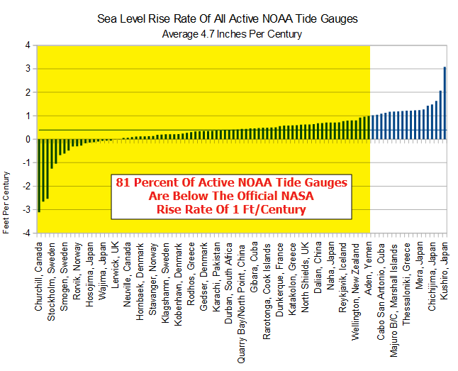
The average of them all is/was 4.7 inches per century.
After reading this whole thread, so far, this whole topic is a horrible joke. We, us, the scientific establishment, can’t measure something that doesn’t exist. The world’s sea level will do what it does, change. We will never know why, how, or when, but it will change. I don’t think it’s much of a problem: the islands that were going to disappear under the rising waters are building oceanfront hotels, the “rich green intelligentsia” are still buying oceanfront property all over the world. There I roads on the Great Lakes that were “high and dry” two years ago and now the water is right at the edge of the road and all the grass that was growing on the flats is now drowned. Give me a break, or a boat….
I live about one and a half miles from the sea. Maybe I should think about moving in the next 10,000 years. My wife disagrees and thinks we should move sooner – in about 2,000 years. My kids? They’re on their phones looking for cheap pizza deals.
Re your observation 2) “SLR must approximately equal thermosteric rise, as hotter seawater expands in volume”.
ARGO data do indicate a significant rise in ocean temperature beginning in the 1980s.
Another interesting observation is that tidal gauge data, all corrected for vertical land movement using GPS, do not give identical sea rise values. The GPS corrections could be inaccurate. However, local sea levels can depend on a variety of regional conditions, such as tides, prevailing winds, temperature, sea shore shape, etc. So maybe tidal gauge variations are real.
They never will except on >60 year time frames. Lunar variables, ocean current variables, and such. Niels Axel Moerner is a better explainer, and far more expert than I ever will be.
Donb, three replies:
1. ARGO was explicitly tbd. You reference a ‘fact’ I am researching for credible accuracy.
2. Nor should they. In the short term, things like El Nino affect them. In the intermediate term, things like PDO/AMO/currents affect them. Geographically different effects.
3. None of the SLR measurements are sufficiently precise for the comparisons you assume.
I don’t know what is the true accuracy of satellite data. Nor do I know what is the average (including open ocean) rise rate. Neither do I decide what the answer ought to be before understanding the relevant data.
I point out that a few studies have analyzed combined tidal data (corrected from land movement via GPS) in one or two decade increments. They conclude that between ~1925 and ~1945, the sea rise rate significantly increased from perhaps <1 mm/yr to ~2.5 mm/yr, just as global temperatures were rising. Then from ~1945 to ~1970, as global temperature was falling, the sea rise rate fell substantially.
Yes, apparent El Nino effects on satellite rise rates are modest and soon return to some trend. But their presence in the satellite data make it more difficult to determine whether the rate of sea rise since the late 1990s is itself changing.
Omg….put your finger and thumb 1mm apart and with a straight face ask yourself if you believe that is accurate for sea level rise.
I have stopped chuckling.
“ARGO data do indicate a significant rise in ocean temperature beginning in the 1980s.
”
That is a pretty neat trick, for devices which did not even begin to be deployed until the early 200s.
“A program called Argo was first proposed at OceanObs 1999 which was a conference organised by international agencies with the aim of creating a coordinated approach to ocean observations. The original Argo prospectus was created by a small group of scientists, chaired by Dean Roemmich, who described a program that would have a global array of about 3000 floats in place by sometime in 2007.[4] The 3000-float array was achieved in November 2007 and was global. The Argo Steering Team met for the first time in 1999 in Maryland (USA) and outlined the principles of global data sharing. The Argo Steering Team made a 10-year report to OceanObs-2009[5] and received suggestions on how the array might be improved.”
https://en.wikipedia.org/wiki/Argo_(oceanography)
Thanks Rud, for a great post on dodgy satellite data.
donb: “Another interesting observation is that tidal gauge data, all corrected for vertical land movement using GPS, do not give identical sea rise values.”
GPS chips are rarely placed on the actual tide gauge and apart from vertical movement of surrounding land, the actual tide gauge [which has often been in place for over a century] moves in one direction only with age under the influence of gravity.
Until GPS chips are placed on the actual measuring device and left there for some years, we won’t get good data.
In the meantime we need to take notice of people like Nils Axel Morner who has a better understanding than most experts on sea levels and who says there is nothing happening SL wise.
As a past builder of sea-front infrastructure I can show how 70+ year old sea walls built to king tide datum are now above that level in all recent years by up to a foot.
I also point out that GRACE gravity data (measuring the mass of the ocean, not sea height), when combined with ARGO data giving temperature, give sea rise rates similar to radar altimetry. Of course, it also makes corrections for Earth’s geoid.
Examination of all satellite sea level data plotted also show short-term rises and falls consistent with el Nino and la Nina events.
Let us return to the target/bullet hole analogy.
The claim has been made that one cannot do much about precision, but accuracy can be made better by adjusting the rifle sights, which are designed to do just this. (e.g. a_scientist January 11, 2019 at 2:59 pm)
Is that so? Read Rumsfeld 2002:
“Reports that say that something hasn’t happened are always interesting to me, because as we know, there are known knowns; there are things we know we know. We also know there are known unknowns; that is to say we know there are some things we do not know. But there are also unknown unknowns—the ones we don’t know we don’t know. And if one looks throughout the history of our country and other free countries, it is the latter category that tend to be the difficult ones.”
The shooter in this example uses cartridges of unknown origin. They might have even been made in different countries. Each one has a specified weight of cordite. That weight will have both random and systematic errors and so this will produce errors of both precision and accuracy. The question resolves to this: Are the variations of cordite weight sufficient to require another adjustment? To the shooter, it can be just another unknown, for some shooters even an unknown unknown.
This matter of satellite altimetry over the sea surface has many of what we can call here “cordite problems”.
The shooter can be firing with a large error that he/she does not even know is happening, simply by using a different cartridge. Without mounting a large experiment on the shooting range, holding constant as many variables as can be controlled, and without expending a statistically large number of rounds, the problem will persist.
How do the satalt guys cope with their cordite problems? They cannot. They cannot mount exactly parallel experiments in orbit to replicate and understand differences. They have to make subjective judgments about how to stitch together the outputs of several different satellite systems. We have to either trust their expertise and motives, or reject it.
The big mistake is to use the final result in the formulation of government policies that affect many people and processes. There are subjective elements and there could be unknown unknowns. As Rud notes, these data are not fit for purpose. There is no possible argument to deny that. Geoff.
Geoff Sherrington
January 11, 2019 at 6:38 pm
Good comments and discussions.
It seems to me that the satellite data are just an interesting scientific experiment that may eventually be useful for something. In the meantime all we need to do is look at GPS validated tectonically stable tide gauges in our own region and go from there as far a local or regional policy is concerned.
It’s just a pity that most politicians seem to prefer the scary stories put forward by IPCC and others. I suspect that it may just be that they prefer supposedly high tech numbers from modern satellites to “old” simple tide gauges? Not good to look old fashioned, especially to the younger voters.
Willis, the last thing they want are accurate, precise measurements.
Rud, rather. Doh!
Excluding measurements on Land, too many fiddles, does the data from the ballons the ARGO bouys and the satilites agree, not with fractions of a degree, but overall.
MJE
Excluding measurements on Land, too many fiddles, does the data from the ballons the ARGO bouys and the satilites agree, not with fractions of a degree, but overall.
Re. the rifle. f one wants accuracy then fastern down the rifle and use the same well known make of carterage. Then average out the results. Usually they will be clove enough to e able to set the sights.
In my army training days, 1944, we fired the rifles lying down, and the armoureres adjustered the sights on the new rifles.
MJE
I agree with those commenters who say the example of bullets fired at a target is not relevant to the question of whether satellite sea level measurements are trustworthy. One reason for saying this is that the satellites are not making multiple measurements of a stable target. Every measurement is at a different location, and by the time a 2nd measurement is made at the same location the tide has changed.
Also, the discussion of accuracy and precision as they pertain to firing a batch of bullets at a target is reasonable, but does not carry over to other contexts. For instance, one of my first fields of interest was astronomy. Suppose an astronomer predicted the moon was going to occult Saturn at a particular time when viewed from a particular location. If the occultation is observed to happen at PRECISELY the predicted time, then the prediction is judged to have been ACCURATE. Note that the astronomer does not make predictions of multiple events, then weigh the results. If the occultation takes place at a slightly different time, no one discusses whether the prediction was precise, but not accurate, versus whether it was accurate, but not precise.
The question of precision of the prediction relates to the difference between the predicted time and actual time of the occultation. The less difference, the more precise the prediction. Accuracy then correlates with precision.
Thus, I see 2 reasons for not thinking the analogy of bullets fired at a target is relevant to satellites making measurements of sea level.
SR
SR
Something I was taught back in grade school and as Rud points out; Close only counts in horseshoes and hand grenades” . Or cruise missiles.
A U.S. Army artillery officer I knew who had just returned from a tour in S. Korea when there allegedly were nuclear artillery shells in storage there said that close only counts in horseshoes and nuclear weapons. He also noted the oft quoted aphorism that if you get into a ring to with a skunk to settle a difference of opinion you may be right but you still come out smelling like a skunk. The latter applies to most interchanges with the alarmist community.
Sea leve measurement by gravity observation from satellites is like measuring my heigt by measuring my weigt, then guessing my body mass index while I am wearing my polar coat, and finally calculating backwards. It will never be precise.
The major problem is that the reference elipsoid (geoide) is unstable. The satellite gravity reference point – the geoides grain size gravity center point – is never in the same position in the earth center. It is moved around by various gravity changers, the moon, the planets, snow cover, atmosphere pressure, mantle movements, earthquakes, volcano eruptions, magma flow etc. How can one measure with millimeter precision when you don’t know the precise position of your refence point.
That’s like putting your target on a flag and shooting at it in a variable wind. Precision and accuracy will be gone with the wind.
Even more fun would be to be shooting from a moving platform.
Actually it’s nothing like how you guys try to portrait it is done but never let facts get in the way of a good story. What you are all basically saying is you are to lazy to read how it’s actually done. The only part anyone has currently got correct is the accuracy of jason 3 is 3.5cm how that gets to an increased accuracy escapes everyone they assume it’s just averaged … it isn’t.
If you actually care to know how they do it .. there is a key thing the satellite must do which is always fly the same path … the hint is why?
Rud if you read this stuff you only actually got half of what they do … this statement is actually the most important part of what you said
My hint is look at how they handle waves 🙂
The key to this is:
“I know of no statistics that can reduce a minimum repeatable precision error of >3 cm to an ‘average accuracy’ of 0.1 mm without a ginormous error bar, which NASA ‘conveniently’ DOES NOT provide.”
As in almost all CliSci products, there is an unsupportable belief that one can achieve high precision through simple division : averaging by whatever method of a large number of measurements.
It is simply not true. They can show whatever precision they prefer (down to ten/thousandths of a degree or fractional mm’s) but they must acknowledge the original measurement uncertainty. The uncertainty of multiple measurements of multiple things at multiple times can not be “averaged out”. It remains in the final product. Always.
Normally, no, using simple ranging, but suspect that NASA must be aware of that and will be using sar (synthetic aperture radar) techniques. That is. several views of the same area, time displaced, to create a 3d image. Then post process the resulting data set. Have done a fair amout of data aquisition for work here and the only way to increase precision is to take several samples and average, but that only works if the measured value is unchanging in relation to the overall sample period. The ultimate limitation being the resolution, the least significant bit uncertainty.
Still have dfficulty beieving that they can get repeatable and consistent mm accuracy over such a range, but who knows what techniques they are using…
Chris.
Chris ==> One problem is really that the ocean are not smooth to any degree — that is, there is not a definite “surface” (not a single ‘sea surface height’ in the sense of mm or cm distances). If you are really interested, I can dig up the pdf of the specs for the Jason series — which includes all of the expected accuracy and precision estimates.
“the Jason technical manuals show error ranges for wave height scatter in the tens of centimeters, original measurement error in the altimetry function of Jason’s 1, 2 and 3 of +/- 3.4 cm. [Ref: Jason-3 Products Handbook, pg 10]”
It would be difficult to get millimetric results if one was working with a 1km x 1km piece of ocean (in its normal state, with waves, ripples, wavelets, etc) frozen solid so it doesn’t change….even close up (standing on it?)
There are so many good essays on SLR — I offer these (some of my own and some of others):
My SLR essays at WUWT
Judith Curry’s series on SLR and Acceleration
Judith Curry’s Special Report on SLR
Rud Istvan’s series
Each of those essays have a lot of links to other essays and data sources.
As I understand it: Every height measurement ultimately depends on the ITRF which determines the location of the mass center of the earth, an ellipsoid is modeled in relation to the ITRF, the geoid model is referenced to the ellipsiod, a datum referenced to the ellipsoid is used to locate the various satellite tracking antennas and lasers that help resolve the orbital positions of the satellites in relation to the datum which is then referenced to the ellipsoid model.
Satellites measure height to an uneven sea surface which varies over time and position and the measurements are resolved as a height from the ellipsoid model. To determine heating effects, the difference between the ellipsiod model and the geoid model must be resolved since the geoid model represents where sea level should be.
A minimum of three interdependent models each with their own inaccuracies plus direct satellite measurement inaccuracies, plus orbital position uncertainty corrections, plus ITRF corrections are used to determine an average global sea level.
Considering every model and measurement and even the ITRF has an error budget that contributes to the overall measurement accuracy, I would like to see the error budget of the sea level measurements that claim to know average global sea level accurate within a tenth of a millimeter.
Radar ranging is a classic case in engineering statistics where your, say 1Ghz waveform, is actually already making one Gigameasurements per second, and whether you record the answer once a minute or a hundred times a minute simply is not going to result in “improved” results, whether the technician’s first year statistics “knowledge” says the standard deviation is the square root of 1/N better or not.
From 1980 until 1995, I spent hundreds and hundreds of days at Huntington Beach. Everything about HB has been burned into my memory.
After 15 years living in a miserable southwestern s-hole, I returned to HB to enjoy the unique and unmistakable vibe…..
One thing that was inescapable is that the sea level had receded. Absolutely, positively, without a doubt. You can parade every Ivy-League imbecile through every internet rag you like, but it will not change a thing…..
Sea levels are NOT rising…..
So-called ‘Climate Change’ is caused by fluctuations in solar activity and only fluctuations in solar activity. Not carbon emissions.
PERIOD……
According to my interpretation of the NASA table, the IGDR altimeter noise is 1.8 cm. The radar is Ku band with a wavelength of 1.7 – 2.5 cm. The noise is equal to roughly one wavelength at the highest frequency in the Ku band. The are claiming an accuracy of 0.1 mm.
This provides a Signal to Noise Ratio (SNR) of 0.006. Most analytical people agree that instruments can provide meaningful data with an SNR of 3:1. If I am interpreting the NASA chart and their accuracy claims correct, NASA is claiming that they can resolve altitude differences which are 1/540th of the signal to noise that most analytical people who I know would accept.
Did I get something wrong?
BH, maybe. But I just used what the exactly copied NASA table actually said.
Take it up with NASA. Not me as just a humble scribe.
Same ol’, same ol’ — claiming tiny differences that measuring instruments cannot measure, to begin with, and then producing hoopla on top of hoopla about those essentially meaningless differences.
High accuracy with low precision:
Two Linear Econometrists were deer hunting. One, the hunter, had the rifle, the other was spotting with binoculars. Lo and behold they saw a nice buck on a hillside quite some distance away. The hunter aimed and fired, kicking up dust three feet to the right of the buck, but with good elevation. “Three feet right!” exclaimed the spotter. The hunter compensated and fired again. This time the dust kicked up three feet to the left of the buck. “Got him!” exclaimed the spotter.
SLR estimate are definately fit for purpose.
What’s the purpose?
If you are palnning long term infrastructure projects ( say a nuclear power plant )
you want to insure that the area wont be flooded.
Even it the error was huge in SLR it would still be fit for this purpose.
How about if you own beachfront property in San Diego, and the government wants to condemn your property because of assurances that, although not currently a problem, acceleration of sea level rise assures that this area is unfit for human habitation.
But in reality there is no acceleration, sea level in that area has barely risen in 100 years, and bogus data and fear mongering are the entire basis for the fact that you are about to have your home taken from you?
Meanwhile you cannot sell for a fair price because of all of the misinformation flying around, and may not be able to sell at all.
https://www.jdsupra.com/legalnews/california-coastal-commission-to-30729/
Now you are not even trying Mosher, you build the sucker 30 feet above the highest tide ever recorded, not on a possibly slipping fault, and in an area not known for “tidal waves”.
Cooling water always a consideration…and NIMBY.
Steven Mosher: “Even it the error was huge in SLR it would still be fit for this purpose.”
If the error were so huge that the sign is unclear, I believe that you would agree that the fitness becomes questionable.
SO if the error was so large that the 1.7mm/decade was reported as 30m/decade, would you then only permit nuclear power plants located at least a thousand feet above sea level? After all, you want to insure it won’t be flooded! Obviously, a realistic Sea Level Rise prediction should be considered when making long term plans, but a huge error can have huge negative impacts.
It is difficult to measure sea level from a satellite.
From the Jason 3 handbook, it states that the satellite revisits the same spot above the earth once every 10 days. That informs us that each square of earths ocean is measured 36 times per year.
Those 36 measurements will include all tides, currents, waves, storms, depressions, lunar and solar influences on the surface level measurement.
Not many measurements to come up with a sub millimeter, accurate, value, I suggest.
In addition, the orbit height accuracy tolerance is 1cm.
https://en.wikipedia.org/wiki/Jason-3#Orbit_Determination_Instruments
Rud: Missed this article earlier. FWIW, I once spent a lot of time looking over some of the satellite altimetry documentation. I came to several tentative conclusions: 1) The drift in satellite altitude (above the geoid) is at least 1 cm/yr, so they aren’t measuring the distance from the satellite to the sea surface in the same way that GPS works – by knowing the orbit of the satellite. 2) I saw lots of information about calibration and validation – measuring the height of the satellite by measuring the distance to a known site on the surface. One of the first sites I read about was Harvest, an abandon oil drilling platform off the Southern CA coast with a GPS receiver to track local vertical land motion. And, of course, the platform must contain a tide gauge to determine local sea level as the satellite passes over. 3) A variety of such calibration sites appear to be used and tested against each other for consistency. 4) So satellite altimetry appears to have become a measure of sea level relative to calibration sites with GPS and tide gauges.
Many large corrections in distance are made for humidity, waves, and the ionosphere. Some of these rely upon re-analysis data and the inputs to re-analysis are changing over time. Any bias in measuring humidity over time or wave height turns into a bias in SLR. The potential for systematic error is large and there have been a number of large corrections for such errors already. I’m not surprised that Jason 3 disagreed with Jason 2 during their period of overlap, but I predict some systematic correction will be found to eliminate this difference. Two independent sets of satellites were used to complete two independent assessments of SLR – and then changes in data processing were made so that they agreed.
Five different groups publish satellite altimetry results. How independent are they? Do they each start with the same raw data and process it from scratch? Or does one team determine satellite altitude for everyone. Does each group compile their own data on wave height, humidity and the ionosphere and independently convert time for pulse to return to distance, or is their a single team doing these calculations too? I know they independently grid their data to produce separate global records.
Take all of the above info skeptically. I didn’t take proper notes of what I was reading as was confused most of the time. None of this story is clear to me from any one publication. But it might provide some useful hints about what to look for.