In late 2018, there were some predictions that there would be a significant El Niño event in 2019. There were strong hints of an El Niño event in both SST data and forecasts. In an April 6th 2018 essay, Bob Tisdale suggested “Looks like one may be forming right now.”
But if we look at the animation provided by NOAA’s Climate prediction center, it sure looks like it has been fading:

And if we look at the recent SST satellite data, there’s no strong signature of El Niño in the Eastern Pacific near the west coast of South America. There is some elevated water temperature, but it is mostly 1 degree C or less:

Finally, a look at the BoM sequence going back to the October 2018 in the top panel, when compared to the bottom panel for January 2019 suggests that the ENSO event is dying:

Source:http://www.bom.gov.au/archive/oceanography/ocean_anals/IDYOC007/IDYOC007.201901.gif
From the most recent ENSO forecast from NOAA’s climate prediction center, dated January 7th, 2019, we have this:
- ENSO-neutral conditions are present.*
- Equatorial sea surface temperatures (SSTs) are above average across most of
the Pacific Ocean. - The patterns of convection and winds are mostly near average over the tropical
Pacific. - El Niño is expected to form and continue through the Northern Hemisphere
winter 2018-19 (~90% chance) and through spring (~60% chance).*
* Note: These statements are updated once a month (2nd Thursday of each month) in association with the ENSO Diagnostics Discussion, which can be found by clicking here.
But, in that same forecast presentation, they show this slide:

Four weeks of negative changes doesn’t install confidence for a growing ENSO event.
It will be interesting to see what evolves. However, the chances of 2019 becoming another “hottest year ever” aren’t off to a strong start.
It will be interesting to see what evolves. However, the chances of 2019 becoming another “hottest year ever” aren’t off to a strong start.
Don’t worry, they have a whole 12 months to adjust the temps to make it happen /sarc /or_is_it?
Last winter, I lost a motorcycle battery, even though it was a “snow sports” rated AGM, to a freeze and was trying to find what day that was. Odd, I can’t see the day that had the same temps I recall from the event, all the temps are 3 or so degrees warmer than I recall it being. Boxing Day, it is showing it being 1F, but when I lost that battery we had a day it never got above 0 and the low was not the -14F but closer to -20. I find this more and more. Days I know the temp was shown officially as one temp is somehow quite different some time later.
Bingo!
Feb 1st they will report Jan as the 3rd warmest ever as usual
all that matters is that they get the predictions out and the headlines therefrom. Whether they are accurate down the track will be buried.
I have said all along that El Nino was not likely this year. Of course I was taken to task.
That said what really matters is overall oceanic sea surface temperatures when it comes to global temperatures and I say they will be going lower in response to very low solar conditions.
Ian Wilson said no El Nino and I have had and still do have much confidence in his predictions(external factors ,which is what governs the climate) which have been the best out there. The models have proven useless and this makes 2 years in a row when they have predicted El Nino and no El Nino to show for it.
Now global cooling has begun (2016) and we have several years of it as we move forward and the useless climate models like the useless ENSO models will be shown for what they are.
The models do not take into account what governs the climate which is the strength of the magnetic fields therefore they can not forecast the next season much let alone the future climate.
“The models have proven useless and this makes 2 years in a row when they have predicted El Nino and no El Nino to show for it.”
.they will claim a little bitty tiny El Nino
Nonsense! The scientists SAID IT … and therefore it’s TRUE! What kind of science denier would ever suggest our scientists are fallible. You cling to your God … and I’ll cling to our science gods
/BIG sarc.
Oct 22 last year I said about 2018, ‘We are closer to both the solar and ENSO 2006 analog year.’
Part of my answer was
When will the ocean cool more? I expect the ENSO situation to go the other way early next spring, with a small short LaNina-ish dip such as HadSST3 exhibited in 2007, before rebounding into what I call a “solar cycle onset ENSO”.
Current BOM ENSO:
http://www.bom.gov.au/climate/enso/monitoring/nino3_4.png
The next El Nino will have more to do with the start of the next solar cycle, the sun’s magnetic field, than the moon’s declination angle.
Salvatore Del Prete,
I am predicting that the El Nino will start (as defined by the BEST index) sometime in mid to late 2019. My favorite prediction is July 2019 but that is more bravado than an appeal to scientific rigor.
Bob Weber,
It is not the Sun which directly controls the time of El Nino events but the Moon. How can this be the case if an El Nino always occurs during the year following solar sunspot minimum? It’s because of the fact that the lunar tidal cycles almost perfectly matches the Solar Sunspot cycle.
I cannot go into the details but one of the controlling lunar cycles for the initiation of an El Nino event
is seven tropical months in length. It is actually the combination of two shorter cycles of 103 days and 88.7 days:
3.75 Tropical months +
3.25 topical months
——
7.00 tropical months = 7 x 27.321582 days = 191.2520174 days
The realignment of the lunar tidal period with the seasonal cycle (in this case
it is 182.6210949 days = 1/2 Tropical year) is:
11.081 tropical years
This is exactly equal to the average time between solar minimums over the last
400 years which is:
11.08 years
So, not surprisingly, it would appear that El Nino events always seem to occur at the same
point in the solar cycle.
It’s the Moon!
there is more to it than that bob. the lead up to the end of the year saw the smallest neap tides in the area i live since i have been born. i am 48. that represents a massive quantity of water not moving to where it did before. i suspect also a major effect on oceanic currents.
do you know where i could find any charts/graphs showing the tidal range variation over say the last 50 years for the north sea and north east atlantic ? the rate of flow into and out of the polar regions must have a large effect on ocean temperatures. during the 90’s i remember spring tides being half a metre larger in amplitude than we have had for well over a decade now in the aforementioned area and i would like to have a look at the variation over a longer timescale.
What was the probability prediction of an El Nino, something like 97 percent?
All climate science must reference 97%.
The magic number.
https://www.tropicaltidbits.com/analysis/ocean/
Look at Nino region 3.4 also if one looks at the SOI index it has not been in El Nino territory hardly at all and moving forward for at lest the next several days that will remain.
So many were so sure El Nino is here. I was one of the few that was not quite sure.
You have to correct the link in your name, an “s” is missing
I see, you did 😀
OK?
I thought El Nino was defined as Region 3.4 anomaly above 0.5C for three months. yes/no? This Australian BOM graph makes it look like we have just about met those criteria. yes/no?
You may have a look here
Exactly ocean tid bits site is very accurate and up to date. below the +.50c threshold
Bob, the criteria NOAA uses is 5 seasons (each season is a 3 month average). We’ve had El Nino conditions starting with the October season (Sept/Oct/Nov) and will probably last through December. However, unless something changes soon we will never reach the 5 season threshold for an official El Nino.
As you refer to BOM:
Source
???
Whatever happened in Nino 3.4 in 2015-16 was reflected in the UAH satellite record. link
There isn’t written “no El Niño”, but “no proper Bjerknes-driven El Niño since 1999”
Bjerknes: Linking the Southern Oscillation with El Niño
Asymmetry of the Bjerknes positive feedback between the two types of El Niño
Further reading
Prognostication without doxastic comittment is anile.
Prodiginous!
Yay for the regions that an El Nino affects negatively, and boo for the places one affects positively.
Regards to all,
Bob
As always, spot on, Bob!
Betting on Bob Tisdale’s facts, are kinda like betting the 3-5 favorite at Turf Paradise.
You got a really good chance of winning, but it is kinda like kissing your….
Im one whos smiling seeing the enso meter swing back to closer to neutral
and hoping it will go the other way this year.
dust storms and starving animals, we don’t need more of
Bob if you did the title?
why the hell are we now using bad English and saying forecastED????
it’s Forecast
no need for the ed
I’ve noticed it happening more often, and wonder if it’s just badly educated media speak creeping in?
It’s simple: El Nino can’t form if the govnt is partially shutdown.
So we can blame the Democrats then.
I’ve plotted a 4-week running mean of ENSO 3.4 anomaly from http://www.cpc.ncep.noaa.gov/data/indices/wksst8110.for I’ve uploaded the plot to Imgur at
https://imgur.com/a/il6YLJ7
The running mean has fallen the last 3 weeks. The graph for 2018 is eerily similar to 2006. In both cases, they rose from a similar La Nina value at the beginning of the year, had a brief speed-bump mid year, and continued then rising. They’ve both peaked just before the end of the year, and then started falling.
During 2007, the value crashed, bottoming out with a super La Nina around January 2008. Will 2019/2020 repeat what happened 12 years earlier?
Walter,
Thanks for the data and the analysis.
I also like working from analogies, especially for processes that we don’t fully understand.
Having a “good” analogy year doesn’t mean you are right, but it clearly shows part of the expected possible outcomes. A super La Nina would certainly provide some interesting weather and/or “climate” for 2019 and 2020!
Another ‘science communications’ – msm beat up cos they can and make an extra buck to boot.
Climate ‘science’ is surely the catwalk route to a ‘science’ public profile these days. Tacky, titty wiggling, butt jiggling intellectual mincing.
Is this what is called El Niño Modoki?
Ignore BOM subsurface graphics early every month; they are alway wacky ‘neutral’… it’s been going on for months.
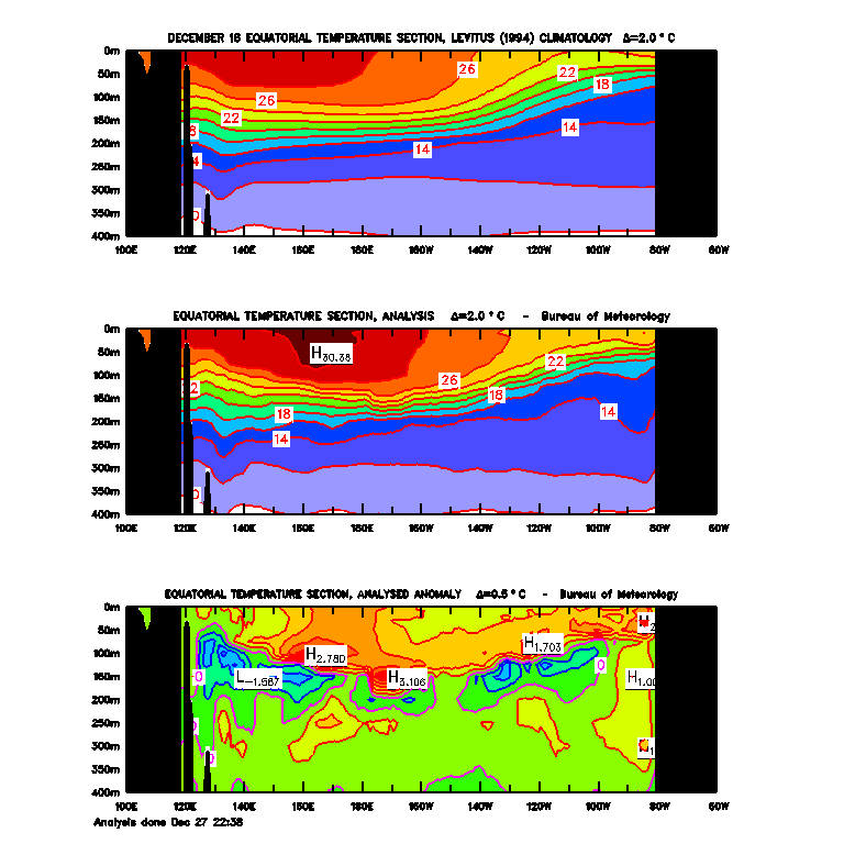
Here is late December
Then wacky January 7
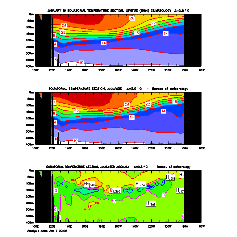
It happens the early part of every month!
Wait till mid month
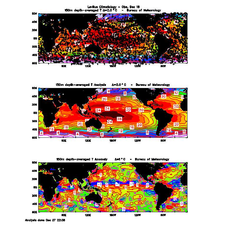
BOM subsurface 150m December 27
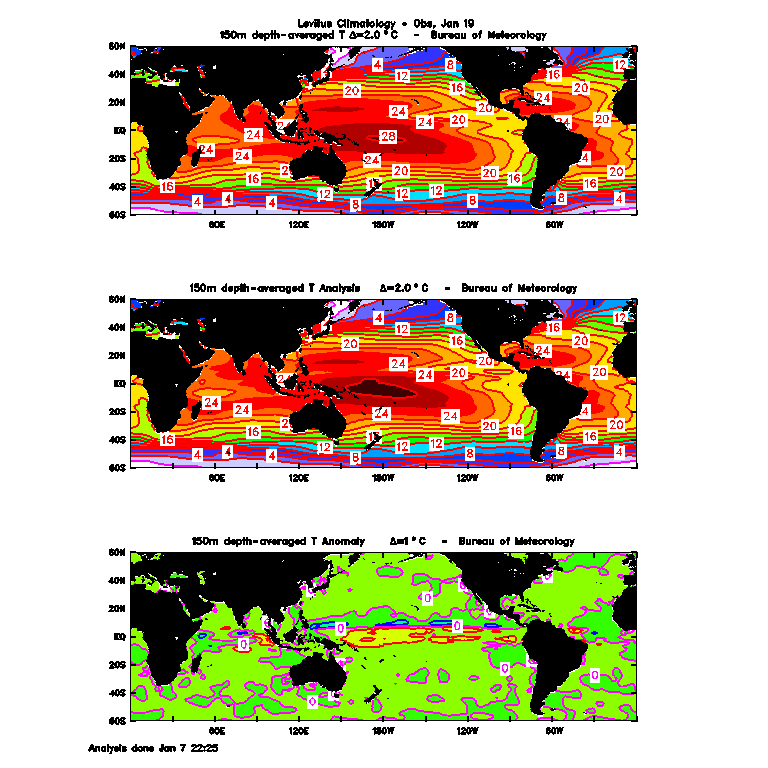
Wacky neutral Jan 7
Honest it’s like that early every month
Agree, nothing from BOM can be believed. The Long paddock site is much better for SOI and also has some gook temperature graphs in 10 year blocks. https://www.longpaddock.qld.gov.au/soi/
” It will be interesting to see what evolves. However, the chances of 2019 becoming another “hottest year ever” aren’t off to a strong start. ”
It’s through the power of adjustment that any thing in a delusional mind is possible. So it’ll be the 3rd, 4th, 5th hottest year on record. In the quest for money and power, facts are not that important. ( unless it helps the cause )
Every organisation which is in receipt of a Grant, should be well aware of what is required in return. That is of course if they wish for future grants.
Don’t expect honest “Science” when Govt. or even private grants are on offer.
MJE
Excactly
Feb 1st they will report Jan as the 3rd warmest ever as usual
SOI dropping but still positive. BOM walkng it back.
Follow the trend. Anthony shows decreasing sea temps so will not reverse suddenly but all bets always off after 8 weeks.
Wouldn’t it be luverley!
Pause.
SOI will be on the increase over the next week.
OMG! EVERYBODY RUN! THE VAPORWARE EL NINO WILL CAUSE GOREBULL WAAAARRRMMING!
LOL
The position of the Madden Julian Oscillation along the equatorial Pacific may be responsible for temporary increase in the strength of the trade winds and likely could be the reason for cooling sea surface temperatures as the MJO position has been in the western tropical Pacific – but, rapidly moving eastward at which time warming is likely to reoccur.
The recent cooling of tropical Pacific waters may partly reflect the movement of the Madden–Julian Oscillation (MJO), which has recently encouraged stronger trade winds over the tropical Pacific. However, the MJO is moving east, weakening the trade winds once again, which may allow the ocean surface to warm again.
Most models indicate sea surface temperatures in the tropical Pacific are likely to remain near El Niño levels at least until early autumn 2019.
It’s not data or observations that matter. It’s feelings that matter. And if you feel that humans are making it get hotter then it’s true. And if you feel that Arctic ice is disappearing then it’s true. And if you feel that polar bears are going extinct then it’s true. Truth is subjective, and the mind doesn’t really exist. So do it in the road if it feels right.
The global SST anomaly tells a story of global, oceanic cooling.
http://www.cpc.ncep.noaa.gov/products/analysis_monitoring/enso_update/gsstanim.gif
El Sin Sentido.
I wrote a comment in a local rag responding to their prediction of a pending El Nino.
It was that “The record does not show evidence of an El Nino following hard on the heels of another, Therefore one now is unlikely” It did not get published.
I am a follower of patterns in nature. Observe a geothermal mud pool. Pressure through heat builds up and plop, out comes a bubble of gas at intervals in time .
El Nino events look to me as though they are the oceans’ way of releasing heat buildup in a cyclical manner. Obviously there is much more at play then just pressure.
Was it Pamela that said ” El Ninos are just the ocean burping heat”? Right on the button IMO
Just an observation
M
I’ve been saying there is too much cold water. Instead of upwelling, cold water is bleeding into the equatorial zone from the continent-sized cold blobs in both NH and SH. As an aside, all is quiet on the subject of the GBR in Oz. The area is inundated with this cold water. This is the real threat to the GBR. Remember the bleaching in Florida reefs a number of years ago when oranges were freezing and the SSTs were very cold?
Some may remember my posts on the last El Nino and why Ts dropped like a rock. Not enough warm water to sustain it.
El Sin Sentido?
https://youtu.be/W3H-NKHIA0M
There is a thread for German winter snow 😀
to comment about
https://tvthek.orf.at/profile/ZIB-1/1203
https://www.google.com/search?q=das+erste+schneechaos+Video&oq=das+erste+schneechaos+Video&aqs=chrome.
So the continuous rise in CO2 doesn’t effect the Ocean Warming as indicated by the El Nino. Hmmm, better adjust the El Nino monitoring areas for temperature; something must be wrong with the sensors. We need money for new sensors.
Who need new sensors when you can just adjust the output of current sensors to be whatever the need it to be.
Why does this look like the result of volcanic activity in New Guinea ?
It looks like the minimum of solar activity.
Don’t count Anak Krakatau in that idea, most of it’s lofted plume was just water vapor, little SO2 could make that trip.
Where are El Niño?

Hmm, Sea Surface Height Anomalies show real-recent and sudden ocean cooling.
September 15, 2018, Note the big warm blob along the central equatorial Pacific; also note the warm northern Pacific and warm northern Atlantic:
November 15, the warm blob in the central equatorial Pacific has gotten wider,
and the heat in the northern Pacific and Northern Atlantic has faded a tiny bit:
CURRENT, January 15, 2019
The pacific warm blob along the equator has faded greatly, and so have northern Pacific and northern Atlantic: