Reposted from Cliff Mass Weather and Climate Blog
Thursday, January 3, 2019
Forget El Nino, StormFest is about to Hit the West Coast
Things often calm down after January 1 during El Nino years….but not this year…with the U.S. West Coast from central California to Washington State about to be pummeled by a series of storms. Rain, snow, wind? Plenty for everyone.
A view of the latest infrared satellite imagery shows an amazing line-up of one storm after another stretching way into the Pacific. A traffic jam of storms.

Let’s examine our stormy future, using a series of sea level pressure forecasts from the UW WRF weather forecast models (solid lines are sea level pressure, shading in lower atmosphere temperature).
At 10 PM today, a strong low is just off the northern tip of Vancouver Island.

10AM Saturday brings an energetic low center into northern CA.

10 PM Sunday? Another storm hits central Oregon! And another system is in the wings.

That storm is right off our coast late Wednesday.

El Nino late winters generally have less action—not so this year!
What about precipitation you ask? Do you really want to know? The accumulated total through 4 AM next Thursday is impressive, with 5-10 inches over many mountain areas and even 10-20 inches over parts of northern CA, the Olympics and southern BC.
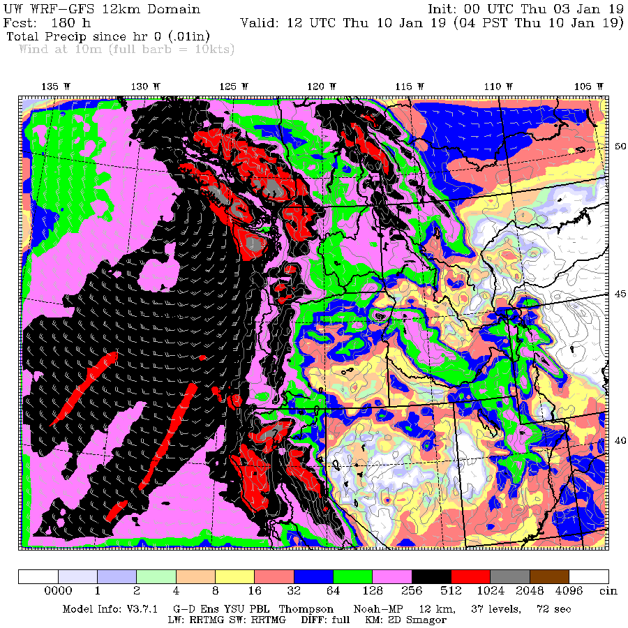
Snow? There will be abundant amounts. For example, here is the accumulated snowfall for the 72 hours ending 4 PM Wednesday. 2-3 feet for the high terrain from the central Sierra Nevada to southern BC. Our winter ski season is secure.

Wind? You bet. Each of these storms will bring strong, damaging winds to a favored area of the coastal zone and mountain peaks.
There is a silver lining of all this action of course: it will provide an immense amount of water to fill our reservoirs and enhance our snowpack, a snowpack that is now in pretty decent shape (see latest summary below). Water resources should be fine next summer.

But all these facts on the ground and favorable forecasts don’t stop some of Seattle’s wacky local media from talking about drought for our region, with the Seattle Stranger being one of the worst (see below). Facts should matter—apparently not at the Stranger.
 HT/DavidB
Of course there’s actually a drought. It’s just a very wet one.
Agree. This is the wettest drought we’ve seen in a long time.
That is because it is oxygen-di-hydride this year instead of di-hydrogen-monoxide.
Oxidane sounds scarier.
It’s much worse than we thought. These extreme weather patterns are just what we would expect from Climate Change.
True.
Also what we expect from Climate Same.
Exactly what Ca saw in Feb 1862
In South America we call it “weather.”
The current weather patterns are not “extreme”, they’re “normal”. But you meant well.
It’s just like that global warming that’s colder. And that sea level rise that doesn’t rise. And the worsening and more frequent storms that occur less frequently and are less powerful. And the reduced crop harvests that are record crop harvests. And as for no more snow – that’s usually an extra foot of snow.
Jerry Brown’s … neverending CA drought caused by your sinfulness for using fossil fuels.
Aka … EXXTREME weather … REALLY EXXXXXTREEEME!!!!!
It’s a ‘man caused disaster drought’ because CA is simply going to flush all their H2O into the ocean.
This is obviously due to climate change,
or aliens.
I noted this forecast was not as precise
as forecasts of the planet’s average temperature
100 years in the future, which are accurate
to three decimal places.
Folks in Cali where the fires were so bad? Get your debris and flooding control fencing up, quick.
…but get approval 1st….
[snip…clean up your act…mod]
Your comment appears to have hit the threshold of three strikes:
.
1) No vulgarities of any kind
2) ditto for people that make threats.
3) other detritus that add nothing to further the discussion
.
https://wattsupwiththat.com/policy/
…
Moderator?
[strike 2…mod]
The blob is gone. The El Nino a Modoki has finally manifested in the SSTs. If Joe Bastardi and the guys at Weatherbell are correct, we in the east are in for an extended period of far below average temps starting about the middle of this month and stretching into March. Old Man Winter hasn’t forgotten about us in the Ohio Valley and points south it seems.
I remember El Nino winters that had late season storm activity on and near the West Coast. For example, storms in SoCal in February 1983, including one that produced a tornado. Also, with this winter’s storm activity being mostly in and north of northern California, with the weakness of this winter’s El Nino, and with a history of storms like these having happened before in non-El-Nino winters, I don’t think the current El Nino is the main reason for these storms.
I think the expression ‘one should be careful what one wishes for’ is appropriate here.
But the thing is, alarmists don’t actually want rain. They really do want the world to burn to a crisp just so they can say “Told you so”.
That’s their only motivation.
Where it matters, this sequence of storms will bring snow and lots of it. Snow rather than rain is another thing that alarmists can’t reconcile with CAGW. For some reason they fail to understand that it always gets cold in the winter. In the same way they fail to understand that polar ice will always reform in the winter because it’s dark for 20-24 hours a day.
More importantly than being dark, it get cold. Much colder than necessary to form ice… Like Much much colder than necessary.
I like this site for storms hitting the west coast.
https://opensnow.com/dailysnow/tahoe
Open Snow is the best! I use them for storm updates in the central rockies
When folks get fixed on an opinion or with the climate stuff a dread, no change is allowed.
Too many want anxiety and fear. Then when counseled that CAGW is no real threat, they don’t smile with relief. They get angry, right up to furious.
And then there are the mildly delusional.
A long time ago I was transferred to Winnipeg, where it can get really cold.
I found out what it is like to walk (ten minutes) to work at 49 below. No wind chill BS.
But the locals when learning I was from Vancouver, would tell stories about how cold it was on the West Coast when it was only at freezing.
“Because it was so damp.”
But in the Prairies while the cold was down to whatever, it was OK. “Because it is a dry cold.”
This would be in the face of a weather report saying it was sunny, blue skies, no wind, at 30 below–and–95 percent relative humidity.
It is the way the physics works, but locals were OK because they really believed it was a “dry cold”.
The subject of blindingly thick ice fog at 35 below will be left to another posting.
Yeah, you know how they are always saying 110 F in Arizona is ok because it is a dry heat? Well, I was hauling a trailer full of Arabians through some of that “dry heat” and the horses, the truck, my co-driver, and I were all in total agreement, it was HOT and we were all miserable until we got back east.
I was hauling a trailer full of Arabians through some of that “dry heat”
___________________________________
Had to do a double take there as I at first visualized a trailer full of illegal aliens……..LOL
“Water resources should be fine next summer.”
Early January seems way too early to make such a statement. At least in California the wettest months are February and March.
After last night’s storm Mammoth is about 1/3 of normal for the season which is a great start but obviously no where close to ensuring adequate summer water supplies.
There are 4 or 5 storms stacked up in the Pacific, so if it keeps up, we’ll have Fourth of July skiing at Mammoth this year, or even into August like a few of years ago. That same year, even Squaw was open on the 4’th of July.
The summer snow patches I hike to and ski North of Yosemite along the PCT have been steadily increasing since the end of the last drought and I anticipate they will continue to grow.
Where are the Californians going to store all this “adequate” rain fall ? They haven’t put up a dam in years–in fact they’ve torn several down. They’ll flush this god-send and then bitch about it later when they have to put in AZ lawns.
20 years ago I recall many Californians driving around with a bumper sticker stating, “Build it, Dam it !”
It would seem that ‘el nino’ weather patterns are no more predictable than any other type of weather patterns.
Full marks to the Planet for refusing to read from the script!
But, but, the climate models !
Southern Arizona is already on track to have a spring wildflower season the likes of which haven’t been seen in a while. 1 inch of slow steady rain last night soaked everything and put more snow in the high elevations.
Most likely. A day trip up towards the Biosphere / Oracle is indicated for around mid to late March.
We’ll probably have a lot of blooming (and fat) cacti, too.
Cool! Please get us some nice pictures, ya know, so we can throw them in the blank, un-reponsive faces of the Humanity Haters. That is always fun!
Not unusual, just overdue.
60 mph wind knocks out power to over 320,000 across Western Washington
Scott Sistek, KOMO Seattle
A very strong thunderstorm came through Whidbey Island on Saturday night/Sunday morning. I was awoken by an explosion, which turned out to be thunder. It only took about 5 minutes, very close lighting and very heavy driving rain swept through. Extremely rare for this area.
I grew up in Northern VA, so I am used to thunderstorms in the spring and summer, but here, lighting is almost non-existent. So it was kind of a treat. Didn’t lose power for more than a half second or so, not like a couple weeks ago when power was out for 4 days and our 10kw generator decided to give up the ghost.
Can’t be a duplicate. Never posted comment this article before. Check your checker.
When posting a comment, if you hit your enter key twice by accident (like a double click) you will get that duplicate posting warning.
The headline sez:
“Washington State Could Face Drought in 2019”
Well, they did say “could”. So they didn’t actually lie.
Just like all of climate change pseudo-science BS, there could be 3 deg C climate warming by 2100. Global SLR could reach 1 meter by 2100. Liberals could stop lying their asses-off for political power. Pigs could sprout wings and fly.
My money is on the pigs with wings thing happening before any of the others.
If you’re a skier looking for fresh powder I like this site: https://powderchasers.com/
Hot, dry summers and drought are a fact of life in Washington State no matter how much snow we get in the winter. Sometimes a long, cool spring helps preserve the snow pack a bit longer, but inevitably most of the snow pack melts and we get hot and dry. At least that’s what I’ve noticed after living here for the last 43 years. However, the Cascades have permanent snow fields and glaciers plus the volcanoes, so we ski year round in Washington State.
We live in Washington State about 100 miles east of Seattle.
We get about 9 inches of total precipitation (water equivalent) per year.
Southeast of us 50 miles, total precip is close to 5 inches. Every summer the temp goes to 100°F (38C°), and higher. Winter temp can get to -15°F (-26°C), although that seldom happens.
From a climate and biome perspective, Washington is very diverse – ocean beach, permanent mountain snow/ice, cold desert, and forests of pine, fir, and spruce.
In fact, this is what climates (note the s) are all about – not a tiny change in temperature over 50 years.
Yea but you better know what your doing if your going off-piste:
https://www.sierraavalanchecenter.org/advisory
You’re and you’re. Fixed it for you.
@John F. Hultquist
I’ve never seen a better skeptic talking point:
I live in a high desert area where last week it was -2F, during the summer it reaches over 100F and to prevent the temperature from reaching 101.5F they want to take 10% of my earnings, put me in a electric car and have me hunting down wood for a fire place for heat during the winter when storms roll thru. So far this winter I’ve burned up 35 gallons of fuel grading roads and the bad storms haven’t hit yet.
What El Nino ? There is none.
Please tell me what that blob of warm water is in 3.4 then?
El Nino 3.4 is below +.50c threshold last time I looked.
currently at 0.58
Wrong currently at+.49c
It is not an El Nino winter. Those start rain in California in September. La Nina years, the rain starts in January to February. The rains this year started in November, and so are transitional.
Nino/Nina don’t always give you the same weather patterns. If you look at the data, it’s about 50/50 for either of them to be wet/cool or hot/dry, or vice versa.
Love the pictures. All those lovely storms normally they are aimed straight at me in SE Alaska. This year, (thank you God of Weather,) they are headed south of me toward lower B.C., WA, OR, and CA. Today the skies are clear, the weather is just below freezing and I am happy. Have a Great New Year all you What’s-up-ians.
Now that power is back on, I can check in and see what is going on. We may have hit a gust of ~60 mph at my house during last night’s windstorm. It was hefty enough to take off shingles above my garage, and knock down several sections of my neighbor’s fence. McChord Field at JBLM (TCM) had a gust of 61 mph at the same time we lost power. Cliff’s post on Saturday about the coming storm stated peak winds in southern Puget Sound could be quite high, based on UW forecasts. By comparison, the NWS did not issue a High Wind Warning for the Puget Sound area until approximately 1830 on Saturday. The NWS pinpoint forecast for my neighborhood was for gusts less than 50 mph. I wish.
Also, Cliff and Ryan Maue both have posts or tweets out today (1/6/19) showing the monster storm headed for the west coast with an ETA of Wednesday, 1/9/19. Could be an exciting week for weather geeks on the coast.
windsong
(Raises hand, waves it briskly, wants to ask question!!! !!!!!)
So, with all of this “very predictable” windmill-power being generated across the Washington-Oregon-CA State grids by this storm, just how much wind energy was uselessly created during this “predicted” wind power “boom” and subsequent “bust” cycle? When the storm was over, how much was suddenly lost – and had to be made up by fossil generators being re-started? How much was generated across the TX state grid AFTER the rains and winds of 12-30, 12-31 were swept away and the whole state was basking in calm cloudy air with essentially NO winds on 1-2, 1-3, 1-4 this year?
I can only report that fossil fueled backup electrical power in my own neighborhood kicked in immediately after the electricity was interrupted. Two of my neighbors, including the one directly behind me, had their Generac NG powered standby generators kick on at 1:40 am. (Gawd, those are noisy. And expensive to run.) And by mid-morning the din of the gasoline powered generators in the immediate vicinity added to the racket. This is the only year I have ever had my little Honda cranked up twice in one year after an outage from a windstorm. First one was just 17 days ago.
I have a Generac Propane 10kw hardwired. It’s not that loud, nor expensive to run. Of course mine is 25 years old and decided it didn’t want to run a couple weeks ago when the big power outage occurred in Western Washington. Maybe they’re louder when you’re down the street? Or they don’t have a muffler?
With winds that strong, wouldn’t surprise me if all the wind mills were feathered.
I’m curious how many of the sainted windmill’s made it through the high winds. There are frightening YouTube vids of them flying apart in high wind.
One of the windiest trips over the bay bridge yesterday I’ve experienced. Lots of white caps on the bay. Quite beautiful!
Pretty good odds El Nino will still develop later this summer according to CPC. The Mjo is likely part of the forcing of the current series of west coast storms. It will be getting into central Pacific soon and so the following week should see more splitting systems affecting Southern CA more.
Before someone tries to characterize this “stormfest” as “unprecedented”, allow me to point out that such extreme _atmospheric river_ phenomena have been recorded on the West Coast since the mid 19th century. One of the worst happened in 1862:
https://en.wikipedia.org/wiki/Pineapple_Express
Such events do occur in El Nino years. And they are related to planetary Rossby waves and meandering Arctic troughs, which can be seen here in the 6-micron “water vapor” IR channel.
https://www.ssd.noaa.gov/goes/west/nepac/h5-loop-wv.html
A better way (IMHO) to view these water vapor rivers from overhead sensors is to use passive microwave signals (85-89gHz), which more accurately record WV phase changes compared to 6-micron IR. Microwave can’t be imaged directly, so it is “blended” with wind data flow, producing imagery that is modeled by blending microwave sensor reading with blended GFS winds. So the output is averaged over more of the troposphere, thus capturing/filtering more of the “deep convection” aspect of these equatorial waves than the IR WV imagery:
http://tropic.ssec.wisc.edu/real-time/mtpw2/product.php?color_type=tpw_nrl_colors&prod=global2×pan=24hrs&anim=html5
Actually it’s the other way around, most El nino effects across the West coast especially California happen from February through April, and often continue to produce a wet spring into May in many areas. Mostly with moderate to strong El Monos.
The wet coast. Land of perpei pseudo drough. And fires…started by those who profit from them. And millions of voters that are dead…or simply do not exist. It’s an amazing place to ponder.
I frequently travel …by gas guzzling motor tweaked Tahoe… across the vast open spaces. Taking pictures of the same awe inspired views. Seems the drier it gets, the more low areas seem to over flow in the spring melt. I’ve been making these treks since the early 1970s. Some years are drier. But recently, small lakes fill over the top of docks. Ducks swim in ponds once nothing but dust.
I think Joe Bastardi makes a great point; Super el Nino’s pump lots of moisture into the atmosphere, which resulted in warmer temps and more rain and snow. One of my ranches had a fire…started along the road. Like the other fires, started near a road or those evil power lines. Those power lines….
And the wife comes home from a “meeting” where a state EMS individual claims the fires will be even worse in 2019…with a wink…and “there is money to be made…”
AND when I was doing a lot of flying, a pilot friend flew lead for drop tankers. He reported to me they were sitting tight waiting for the fire (in CA) to expand so to milk the event. That was the 25 years ago. So I watch and observe the goings on.
Could write a book. But….I don’t particularly like concrete boots.
You are on to the game mate. Agree 100%
This is not an El Nino year. It is forecast by NOAA to be a modest one, but there isnt enough warm water to make it. Ive been saying for a year or more that with the cold blobs, climate was going to decouple somewhat from ENSO and that is what we are seeing in this “unexpected” La Nina type weather. Note also the cold water over the GBR. We havent been hearing the whingeing about the imminent extinction of the reef lately. I think there could develop a concern in Australia about the cold water recalling the bleaching and dying of the Florida reefs during a cold spell a decade ago.
I live just a bit south of Seattle. Saturday night we had winds blowing 10 to 30 mph, with sustained gust of +50 mph. Tall, tall trees, high winds, and power lines on poles make for regular power outages. This happens 2 – 3 each winter. The power went out at 1:00 am as the wind gusts accelerated. Sleep was unachievable, with the high wind noise and fir cones and broken bits of branches bumping the house. The winds started abating about 4:00 am, so I stoked the wood stove and went back to bed. Grid power came back up at about 7:00 pm this (Sunday) evening.
This stuff happens. It’s all natural. It is just common sense to have a back up generator, a wood stove and a supply of dry wood, fresh batteries and flash lights, and a sizable reserve of candles if only for the ambience!
An oldie but still relevant….
Seems it never rains in southern California
Seems I’ve often heard that kind of talk before
It never rains in California, but girl, don’t they warn ya?
It pours, man, it pours…
“California has worn me quite thin, I just can’t wait to see you again,
Come Monday …”
https://youtu.be/e0—Q97pG4
Speaking of oldies. Yes, CA has worn me quite thin …
Snowfall so far in Sierra this winter is not plentiful. A low snow winter in Mammoth is 300 inches, a high snow winter 500+ inches, so far 2018/19 is 97 inches, so well on target for a low precipitation winter.
A good storm cycle in the Sierra is 40 inches, a reservoir-topping one 100 inches.
Get back to me when these great storms recharge all the reservoirs…..
Alternatively, think about whether 2019 will be another summer when water supplies and drought are an issue…
Good thing YOU aren’t using any fossil fuels in your life. And IF you were a 4th generation Californian as I am … you’d know that MOST of CA’s precipitation is dropped AFTER Jan. 1. Rarely, if ever, does the Sierra get massive snowfalls prior to Jan. 1. So sit tight, stack up your carbon sticks to burn … and watch what happens when “the storm doors open” in the Pacific. Same as it ever was … same as it ever was …
And rest assured that Jerry’s “never-ending CA drought” will eventually return … all as part of the entirely NATURAL cycles that make up CA’s climate. Same as it ever was, same as it EVER was.
Oroville has had about 12″ so far since the fall, about the same as last year so far (although a late start hence the Camp Fire).
Apologies for my ignorance but looking at the latest anomalies for the El Nino it seems to be struggle to gain any traction. Is there anyone who can point to some places I can read up to see if what the likely consequences of this would be?
Apologies for my ignorance but looking at the latest anomalies for the El Nino it seems to be struggle to gain any traction. Is there anyone who can point to some places I can read up to see if what the likely consequences of this would be?
The entire “CO2 Climate Change” fiasco is due to the Arrogant, Inept Solar physicists. For the last 100 years, they have been saying that the Solar Output is constant. And yet, we can see the “11 years” solar cycle showing that the solar output varies. They made some ridiculous assumptions about how the Fusion process operates, without any verifiable experimental/actual data.
It is just in the last 5 years that an interior solar model [verifiable] that can explain the “Sunspots” has emerged. Bottom line, Solar output is going down. How long will it last? You can see the latest “Solar physicists guesses” by looking at the “Solar cycle” predictions.
Unfortunately, these clowns are the ones that we get our data from. They orbited a “black body absorb-er” that needs to be replaced, since it doesn’t work correctly. Ultra high energy data is “essentially ignored”. The next version is going to fix this “problem”.
Now, we have warm oceans, and the “predicted” El Nino is not going to happen. It takes an increase in Solar Energy to cause the El Nino [ocean temperature “lags” put this out-of-sequence with direct Solar energy measurements]. No El Nino, but a giant La Nina is coming due to reduced Solar energy as indicated by the Solar cycle.
X is exactly what one would expect if man-made catastrophic global warming were true.
With “X” being whatever weather event has been in the news lately.
You are comparing apples (solar irradiance) vs. oranges (solar magnetic activity).
Solar radiant output, due to the internal thermonuclear process, _is_ virtually constant,varies by only 0.1%, even over 11-year magnetic cycles.
Solar _magnetic_ activity (sunspots and such) does vary considerably over 11-year cycles. This activity has a significant effect on the Earth’s ionosphere and radio propagation. But no compelling evidence of this 11-year “signal” is seen in climate or weather data. Just a lot of hand waving and conjectures.
The solar wind and EUV irradiance also vary. See Solar Dynamics Observatory: The ‘Variable Sun’ Mission.
Solar wind modulates galactic cosmic rays inversely with a distinct 11-year signal. EUV irradiance happens to be the exact mechanism which ionizes and modulates the ionosphere with a distinct 11-year propagation cycle, which faithfully mirrors the solar magnetic cycles.
But there is no compelling evidence of this 11-year signal in the troposphere, where climate and weather occur. It most likely exists, on a very small scale, but is very faint, and undetectable against the greater”noise” signal of natural variability.