One of the problems from the #CampFire in Northern California has been the thick smoke that has permeated the Sacramento Valley and even the coast, San Francisco, and the Bay Area. These MODIS satellite images tell the story.


Animation, GOES WEST:
One of the problems from the #CampFire in Northern California has been the thick smoke that has permeated the Sacramento Valley and even the coast, San Francisco, and the Bay Area. These MODIS satellite images tell the story.
Animation, GOES WEST:
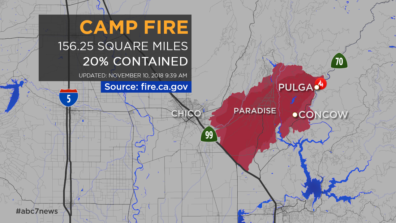
Here’s a source for updated information.
http://www.fire.ca.gov/current_incidents/incidentdetails/Index/2277
Stay safe, all!
Pop,
I note that the cause of the fire is “under investigation.” I seems unlikely that it would have been due to lightning at this time of the year, so, a human cause may well be the logical conclusion.
The uk press are suggesting some sort of problem with the power lines
Yes, ‘line slap’ is being investigated. That would if proven put the utility providers behind the 8 ball again, as well as current state regulations.
The responding fire team indicated that the grounds underneath the lines were properly maintained according to the regulating law. Line slap is going to have a hard time lighting a fire directly UNDER the lines in a 20mph wind situation.
The primary catastrophy of this fire is Pulva canyon which laid almost perpendicular to the wind and acted as a tinderbox to spread the fire’s path – if you look at it on Google Earth from the ridge beside Doogwood Creek (what the fire should have been named) its just a giant flame holder.
Just double checking on my comment above and astonished that power line/equip,ent malfunction appears to be responsible for many of California’s wild fires
https://sanfrancisco.cbslocal.com/2018/06/08/12-northern-california-wildfires-caused-by-pge-power-lines-equipment-failures/
Sympathy goes to all those that have been affected
Tonyb
Deep pockets are always at fault.
and increase from non native species-
“Invasive plants and Wildfires in Southern California”
ttps://anrcatalog.ucanr.edu/pdf/8397.pdf
For those who have been burned out, injured, or have lost loved ones – all the sympathy in the world.
For the Sacramento and Bay residents choking on the smoke from it, I say “GOOD!” You voted for the people that created the problem; it’s about time you suffered some of the consequences.
I live in Sac-a-tomato country. But don’t blame me, I consistently vote for the losers who didn’t stand in the way of good forestry.
Could have been the railroad too. The fire burned right down along the river for most of a mile but never jumped even where it could have.
It was reported earlier this morning that Pacific Gas and Electric has notified the California Public Utilities Commission that they detected a problem with a transmission line in the area in which the fire started at about the time the fire started. The report was on the local MSM radio station, so …
More information will, I hope, be forthcoming.
Burning power poles can topple and bring hot lines to arcing contact in a matter of minutes. The precise timing will be critical.
Hoo! Jo El must be a professional. Power lines have overcurrent trips and zero current trips.
DH<
You need to learn a little more about power transmission systems before making snide comments. You can start with a three shot and the large breakers used in power transmission. Do you even know what a current transformer is and its purpose? Do you have a clue as to what actually happens with line slap? Do you have a clue what could cause a ball of fire (arc) to run up a line and where it might end? I could continue if need be.
I notice that InciWeb.org is down, that reported so well on the Ferguson-Yosemite fire. And rumors that the feds are defunding CalFire for incompetence.
I hope you are safe there Anthony.
A really terrible event, our sympathy with all people affected, especially those whose relatives or friends may have lost their lives .
Some years ago I spent couple of weeks in Grass Valley/Nevada City (about 50 miles as crow flies from the Camp fire) noticed that many houses are of wooden construction located either within or on the edge of pine forests, beautiful locations, lot of healthy fresh air but absolute fire hazard.
Keep on keeping on, Anthony. We are all cheering for you.
Being a WX dude, what are normal wind patterns this time of year? Usual unreliable papers and TV claim basic pattern is northeast to southwest and the reverse. Latest pics look more north to south.
Gums
Wind patterns are variable this time of year due to the changing seasons.
I are you safe from this?
IIRC, you live near Davis, so you should be under fairly thick smoke, but away from the actual fire, Anthony. It looks fairly bad.
There appears to be another fire, south of the Camp Fire, in both the 11/9 and 11/8 stills. What fire is that?
Meanwhile, our two major Southern California fires are not contained (Woolsy) or barely contained (Hill). Fire crews have been on the lines for well over 24 hours at this point, and were hoping that the winds would die down today so that they can get some rest. The current long-range weather forcast is for the Santa Ana winds to pick up again tomorrow and continue through Friday. Let’s hope that the forecast is wrong.
Looks like the fire intensity is declining with lighter winds and this tends to keep the smoke at lower altitude where it can more efficiently mix to the ground. The upside is that reduced intensity also makes the fires easier to control, so hopefully the fires close to urban areas can be put out.
Hopefully some winter storms will bring rain soon and put an end to the fire season, but unfortunately the latest 12Z GFS (2018 Nov 10) is not showing much for California until Nov 23-24.
GOES WEST animation smoke speed is some indication of the huge power of the wildfire. Very impressive.
170 miles away, at SFO airport, the smoke was so thick that they closed all the outside air dampers on the air handling units. You could look across the International Terminal and see the pall of smoke. Eventually, the filters caught most of it as the air was recirced through the return air ducts.
“Trump threatens to withhold California fire aid, citing state’s ‘gross mismanagement’ of forests”
https://www.foxnews.com/us/trump-approves-emergency-declaration-for-california-as-wildfires-rage-across-state
Anthony, I was struck by how green the country is in the region when I viewed the first image a few days ago. Is it fairly coniferous in that part of California? It looked like there had bern a lot of rain over a season.
Gary,
The south edge of Paradise, sometimes called the “Banana Belt,” is at about 1,000 to 1,500 feet elevation. It is dominated by grass, with manzanita, ceonothus, digger pines and bay trees. At the north end of Paradise, you are up to about 1,800 to 2,000′ and there are oak transitioning into pine, although in the urban area of Paradise itself, there are a lot of exotic ornamentals that have been planted. My former in-laws had property with mature walnut trees. Then there are the numerous trailers made of particle board!
Anthony ==> You aree quite safe there in Chico?
This guy recorded the first few minutes of the start of the fire near Paradise California….
Talk about an explosive fire !! Weird behavior.
Next week the CPUC is having a meeting to discuss “Utility Wildfire Mitigation Plans (SB 901)” (1).
A reference to the meeting is noted on twitter here- https://twitter.com/californiapuc/status/1060941444091953152
“We want your input into the wildfire mitigation plans the utilities are creating. Join us for a Pre-hearing Conference on November 14 at 10:30 a.m.”
1) http://www.cpuc.ca.gov/General.aspx?id=6442459371
Anthony ==> Yiu are safe and well in Chico?
I still don’t understand why they don’t put out these fires when they are small. That is the time to bring in the big guns…not after the fire is huge and uncontrollable. Am I wrong about that???
They grow too fast. Only reasonable mitigation is fuel reduction, but watermelons don’t allow it.
Aye–controlled burns when the wind is agreeable to such activity rather than santa anna wind driven flames. I recall reading last year after the grape valley fire that the CA government had defunded a plan to bury utility (power) lines in vulnerable areas True??
Full grown dry underbush, leaves and needles are something that goes bang in seconds. Add wind and boom.
The forest needs fuel control (chips!) and regular controlled burning, if ignored, will go in big flames one day.
Here in the north the risk is small to none most years, but each location get superdry conditions one time in twenty or fifty years. Then something or somebody starts a fire and they’ll blame CAGW.
From ABC news, parallel with other reports:
https://abc30.com/pg-e-says-it-had-problem-near-starting-point-of-camp-fire/4657590/
That’s why there’s not been much blame cast on “climate change” for the fire…
R.S. Brown,
Time Magazine didn’t miss the opportunity:
https://www.yahoo.com/news/town-paradise-abandoned-california-wildfires-162858865.html
I spent 12 summers working on a fire suppression crew. When I watch this it makes me sad thinking how dangerous it is for everyone involved. California has the distinction of having a dry climate and a propensity for extreme winds. When I was very young we lived in Orange County so I remember the hot dry Santa Ana winds very well. Of course, I can’t help but notice that just like here in BC the population has mushroomed and the hills are filled with beautiful homes.
Anthony, I send my best wishes for your health and safety and hope you and family and employees stay safe, as this is a terrible situation. If anyone is trapped the best course of action, if possible, is to try and get into already burned areas where there is no fuel left. Otherwise, stay upwind far away from the fire front, and out of dry canyons and gulches. It looks like even cars can’t outrun the fire in those narrow areas. Good luck to you all and stay safe.
Latest map (11/11 17.00GMT)
Fire stopped at the route 99 just outside the town of Chico
http://www.spiegel.de/video/indien-stromleitung-setzt-baum-in-brand-video-1777759.html
Powerlines and vegetation
http://cliffmass.blogspot.com/2018/11/strong-diablosanta-ana-wind-initiate.html
“Importantly, the winds were again highly predictable, poor warning were given to the communities, a failing electrical system may have contributed to one of the fires, and many of the people affected were living in the wildland-urban interface.”
“The bottom line: the strong winds were expected and well forecast. ”
“And then there is fire initiation. There is some initial evidence that the Camp Fire near Chico was the result of a failure of a high-tension power line that started the fire. PG&E, even with very winds forecast, decided not to de-energize their line–probably a big mistake. Just like the Wine Country fires of October 2017. And just as disturbing, local officials did not use the Amber Alert system to warn people of the exploding Camp Fire.”
Hoping you and yours, as well as all of the WUWT team and community, are safe from this terrible fire.
Be safe and keep in touch.
PG&E customers- “PG&E’s My Energy” account stated this yesterday:
“If your power has been turned off due to the Camp Fire, your online usage data reflects estimated and not actual usage.”
Is noted in RED just above the announcement of our climate credit “Your previous bill may have included a CA Climate Credit, so your current bill may seem larger or smaller than usual. No action is required. “