Florida Major Hurricane Strikes: Still No Trend
by Roy W. Spencer, Ph. D.
I’ve updated a plot of Florida major hurricane strikes since 1900 with Hurricane Michael, and the result is that there is still no trend in either intensity or frequency of strikes over the last 118 years:


This is based upon National Hurricane Center data. The trend line in intensity is flat, and the trend line in number of storms (not shown) is insignificantly downward.
Nevertheless, the usual fearmongers are claiming Hurricane Michael is somehow tied to climate change.
After all, the Gulf of Mexico is unusually warm, right?
Yes, but if you look at the history of Jul-Aug-Sept average sea surface temperature (SST) anomalies over the eastern Gulf (available here, 25N-30N, 80W-90W), you will see that since 1860, this summer is only the 9th warmest in the eastern Gulf of Mexico.
Even more astounding is that out of the top 10 warmest Gulf years since 1860, 7 occurred before 1970, which is before we experienced any significant warming.
So, all the “experts” can do is make vague claims about how major hurricanes like Michael are what we can expect more of in a warming world, but the data show that – so far at least – the data do not support the theory.
Major hurricanes are part of nature. As evidence of this, I will also remind people of the study of lake bottom sediments in Western Lake in the Florida panhandle, not far from where Michael made landfall, that showed the last 1,000 years have been relatively quiet for Category 4 to 5 hurricanes, but the period from 1,000 to 3,400 years ago was a “hyperactive” period for intense landfalls at that location.
Hurricane strikes in the U.S. are notoriously variable, as evidenced by the recent (and unprecedented) 11+ year “drought” in major hurricane landfalls, which was finally broken in 2017.
Where were the claims that the hurricane drought was due to global warming?
Crickets.
Attributing the latest hurricane in any way to global warming is the ultimate in cherry-picking the data. In fact, they don’t even show the data.
Which brings us back to those vague claims by the experts.
UPDATE:
I also included Michael in the count of ALL U.S. landfalling major hurricanes, again from NHC data. The marked downward trend since the 1930s, 40s, and 50s is quite evident:


Where is the news story about THAT?
More crickets.
But there is a definite trend in finding out the lax building standards in Florida or parts of the state after the storms.
Problem with that is so much was built before those standards were put into place…
..and you can’t force people to tear down and rebuild
Ah, but if those home owners want to remodel their property, then you can require almost anything you want. And this can get much more invasive if the property is so damaged that it requires a complete rebuild. Some property can’t be redeveloped under new water front regulations. An existing foundation that can be utilized is often the key to rebuilding.
This is highly dependent on where you live.
In NJ, if a remodel affects less than 50% of the square footage of your home you do not have to upgrade to the current codes. For an addition, only the addition needs to meet the current codes. If a home were so damaged that you had to do a complete gut-and-rehab, then the most current codes would apply.
Other jurisdictions, I am told, are crazy stupid about ANY work done on a residence, and may force an upgrade in your electric when you replace your windows, as an example.
They did exactly that to some people after Superstorm Sandy. The state government mandated that people in the designated and expanded flood zone in Connecticut have flood insurance, and the government allowed the insurance companies to require that your first floor be a certain number of feet above sea level. For many people this meant that you had to rebuild your house to get flood insurance, or be in violation of the law requiring flood insurance. Most of the homes that didn’t meet the requirements were sold cheap to developers who tore down historic homes and built modern monstrosities in their place.
Wait a second…that area has been hit by multiple hurricanes since the time that Andrew led to more stringent building codes and standards.
And there are plenty of largely and even completely intact structures right down to the very beachfront.
I am seeing every day reports of “utter destruction” and “towns levelled” while showing photographs and video in which multiple intact or lightly damaged structures and abundant vegetation is right there in the picture!
At times I have to wonder about the sanity, and certainly the honesty and ability to appraise what is plainly visible, of those doing the reporting.
Let’s face it…there is a dearth of people willing to look with their own eyes and think critically using their own sensibility, at what they are being shown and being told.
When a reporter or a headline states “complete destruction” and “towns wiped clean off the map”, and the accompanying visuals show nothing of the sort, what the hell is going on?
When sustained winds are 20 to 35 mph hour than the strongest measured gust and instruments were positioned right where the eyewall came ashore, what is going on?
When the visible damage does not match up with what is well known to occur given a certain wind speed range, what are we to think?
Florida was basically settled from North to South. The pan handle (L.A. Lower Alabama as it is called) was settled long before Henry Flagler built his rail road down the east coast. Therefore the percent of older buildings is higher than other parts of the state.
Rotor,
Yup. St. Augustine (1565) a long time before Miami (1896). Foundation dates not strictly comparable, and St. Augustine was destroyed and moved at various dates, but still…
Seeing the devastation after Michael came through the panhandle, I was amazed to see a number of homes that were untouched sitting amidst the wreckage of surrounding homes. The surviving homes all looked to be of more recent vintage, so I think it can be assumed they were built to modern building codes for hurricane prone areas.
So the world is not about to end? Is it time for the obligatory “women and children hardest hit” joke?
Don’t forget the increased wars and all our climate refuges.
Thanks for the reality check Dr. RWS
I doubt Michael was a real cat 4. Seems like all the damage was right next to the ocean where the surge and waves did the damage.
Or perhaps the new building codes are effective. But no building code is much good against surge and waves.
Correct. No structure can be expected to stand up to being hit directly by crashing water, waves and surge impinging directly on it.
I wouldn’t agree with that – an elevated (on steel reinforced concrete piers) ICF (insulating concrete forms, built with steel reinforced concrete) home would absolutely survive. And that is EXACTLY what the “code requirement” should be for building or rebuilding (or for extensive repairs or remodeling).
It is the endless stupidity of building wood-framed “matchstick” houses inches above the sand that results in calamity when storms come ashore. That type of construction simply should not be permitted (no pun intended) for beachfront, flood zone, or high wind exposed areas.
Well yes…if it is elevated, then the waves are not crashing onto the structure, as long as it is high enough.
And if it is a concrete fortress, then yes, in will likely stand up to even huge waves driven by hurricane force winds right onto the walls…for a time.
Thing is, people that can afford beachfront homes do not seem to want to live in windowless fortresses, they want light and air, decks and such.
Of course, hurricanes have also been known to destroy beachfront homes on stilts by undermining them, and even by carving inlets where the home once stood.
Personally, I bought a concrete block house in the highest part of Southwest Florida…in the only place for many miles that is not in any evacuation zone. Concrete beam, steel reinforced, tops the walls, and on it is a hip roof (no gables or dormers), with concrete tiles.
And automatic roll up storm shutters on every door and window and across the patio too.
The hip roof is the way to go from an engineering standpoint with regards to hurricane force winds. In several ways as a matter of fact.
There’s no way Michael was a class 4. That designation states that most trees will be destroyed/damaged by wind. Photos of the beach community that got wiped clean by storm surge show undamaged trees. That 155 mph wind speed was estimated from satellite data, and was marked suspect by analysts.
There’s a forest of damaged trees. Check out some of the fly-over footage near Tyndall AFB. In my humble opinion, Michael was more likely a Cat 4 than Harvey. Mexico Beach is / was one of our favorite vacation spots. The Driftwood Inn is mostly standing but cottages, etc. are long gone.
here’s one of the many videos:
100 mph winds will do that to pines.
….. as it happened in England on 15-16 October 1987
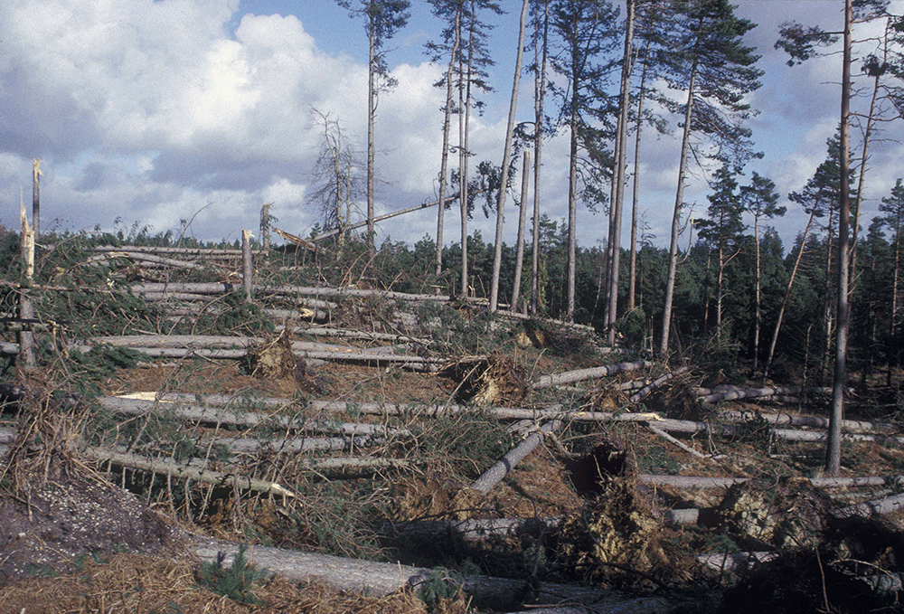
This is not much of a forest…it is called scrub. Note the diameter and spacing of the trees..
Tyndale recorded a maximum wind gust of about 130 mph. That’s more than enough to snap pines. 100 mph sustained will do it as well, which is about what would be expected with 130 gusts.
Yet at ground zero there were little to no trees are damaged. Check out the buildings across the street from the beachside neighborhood that got washed away – very little roof damage. Unheard of in a cat 4 storm.
Here’s a video flyover from Mexico Beach to Port St. Joe. At about the 1-min point it shows the downed water tower. Take note of the tree damage in the background. All this area across the main road is uphill- well away from storm surge – still significant damage. The palm trees fared much better in the wind than the pine and other species.
MOD – please consider removing my last video post – although it’s available on YouTube, it was marked NOT FOR BROADCAST
Lot of undamaged roofs that close to the beach. Not consistent with cat 4 rating. And Michael was supposedly 2 mph shy of a cat 5. Don’t think so…
Cat 4 (major) 130-156 mph 113-136 kt 209-251 km/h
Catastrophic damage will occur: Well-built framed homes can sustain severe damage with loss of most of the roof structure and/or some exterior walls. Most trees will be snapped or uprooted and power poles downed. Fallen trees and power poles will isolate residential areas. Power outages will last weeks to possibly months. Most of the area will be uninhabitable for weeks or months.
Cat 5 (major) 157 mph or higher 137 kt or higher 252 km/h or higher
Catastrophic damage will occur: A high percentage of framed homes will be destroyed, with total roof failure and wall collapse. Fallen trees and power poles will isolate residential areas. Power outages will last for weeks to possibly months. Most of the area will be uninhabitable for weeks or months.
Newer construction complies w/ Florida’s updated construction codes. One beach house that fared well was designed for 250 mph winds. The Club at Mexico Beach built to 2007 codes sustained roof damage (2:30 min into second video). I’ve stayed there – I recall very heavy hurricane sliding doors. Damage appears consistent w/ Cat 4 in description above. Older buildings are significantly damaged or gone. I’m a climate realist and as a Scientist/Engineer, was trained to be skeptical. However, I’m not a hurricane damage expert.
It is important to keep in mind that the force of wind is proportional to the square of the wind speed.
155mph wind is vastly more damaging than 130 mph.
About 50% more force per square inch is imparted across this range.
I have driven through the results of many hurricanes.
After Hugo, pine trees 18′ to two feet across were snapped like toothpicks, for over 100 miles along I-95, and that was over 100 miles inland.
Those pines are vastly stronger than these scattered twigs of trees shown in the videos posted here.
I agree with the people who are pointing out that intact trees and structures at the point of landfall proves that the official wind speed is being hugely exaggerated.
Just in this visual right here, we can see trees intact right in the sand on the beach!
155 mph will knock down well built masonry structures like they were loose piles of wood to begin with.
Most of the damage we are seeing near the beaches was from storm surge, which was itself far less than the surge created by Katrina at landfall…less than half as high.
At this coastline and offshore profile makes the area struck particularly conducive to high surge being created.
A video of a few hundred or few thousand feet of an isolated area of sparsely scattered trees is not meaningless, but it must be taken in context, evaluated as to the size and spacing of the trees, looked at in a far wider and broader view point…
Let’s not forget that there were almost surely some tornadoes touching down in these areas, and those do not count as applicable to evaluating hurricane wind speeds AFAIK.
Intact asphalt shingles at the place where the eyewall came ashore makes it impossible that winds were anything like what are being attributed to this storm.
And the 155 is supposed to be the max SUSTAINED wind. Of course there will be areas of greater gusts imbedded in an area of 155 mph sustained, so where is evidence of that?
There is none, that is where.
I have shredded live oak trees and many snapped pines far greater in diameter and that were in woods much more closely spaced, right here on my own property from Irma last September not to mention palms of several species including sabals, with trunks snapped in half, with the crowns blown clean off or snapped off, etc.
And winds in this area were no place found to have been measured greater than about 90 or 95 mph.
What is left standing says as much if not more about what winds were existing than what was damaged or broken.
Because we can have damaged trees to begin with, or a diseased forest, or improperly or improperly or defectively constructed homes and structures, and these could be easily broken or damaged by high winds
But an intact tree of a known species and diameter has a maximum strength and a fastener can only stand up to a certain amount of force, and then they will break or fail.
A home wiped from it’s slab by surge cannot tell us what the max wind was, but something standing intact can tell us a lot about what the range of possible wind in that location was.
Posting something on an internet blog is not a broadcast.
Sorry, Icisil, but we have greatly improved our construction methods since that was written. My home was explicitly built with both a Hurricane and a Tornado rating. While I am a bit inland, I took no damage at all from Harvey, and I was not alone. New construction just holds up a lot better to windstorms than our predecessors.
I’m not saying that you cannot express doubt about whether this is as bad as it is made to sounds. From the graph alone, we can see that it was not the Worst Hurricane To Ever Hit Florida like the TV was hyping. However, you are making yourself look like a conspiracy theorist.
Thanks for your work! Linking this out to a bunch of people.
This can’t be true. 50, 60 years ago, we would only occasionaly read about a bad storm or other bad weather event in the news, and now we read/hear about them 24/7 in breathless prose and in technicolor. Weather folk even risk their lives to be out in ungodly weather to show us how bad it is, so how dare you.
That is how we know the weather is getting worse.
QED, case closed, the science is settled, think of the children. /sarc
Bruce, you forgot to mention the ominous “Storm Center” music that the TV station play during the intro/outro. Can’t have things like hurricanes, severe thunderstorms/tornados, or blizzards without the ominous “Storm Center” music.
Definitely no trend, but it appears that out of two dozen hurricanes only two or three happen in the years of the sunspot cycles maxima.
http://www.vukcevic.co.uk/FH-SSN.htm
It also looks as if at the time of high period of solar activity (Grand Maximum) 1940-2000, the hurricanes’ low wind speed prevailed.
Camille was in 1969.
From 1940 to 200 low wind speeds prevailed?
Huh?
Many of the most intense storms we know of happened during those years.
And looking at US landfalling storms for evidence of a solar effect makes no sense.
What about the rest of the world?
Does the Sun cause storms to form and strike the US preferentially, or to avoid doing so?
Besides, our data is highly skewed to give us a lot of info in the modern era, and more so the more recent the year is, and very little and incomplete data before the satellite era.
If these events are random or randomish, we would expect to see lots of clustering and spurious correlations with other data.
I think we will likely need hundreds of years of having good data for the whole world over many ocean cycle periods to even have moderate confidence in drawing any reliable conclusions about such correlations, or lack thereof.
Right now we have zero reason to even trust that the simplest things we can measure are being honestly and accurately reported or even measured properly to begin with.
If the same pattern holds then the threat of major hurricanes striking Florida will vanish sometime around 2140 – 2160
4 4 7 3 3 5 – 2 2 3 1 1 1 0
Climate science is so quaint. But science doesn’t matter. And facts don’t matter. AGW is the foundation of a full-spectrum-dominance world technocracy, where only the ‘elite’ are exempt. Hunger Games? It’s a cookbook, dude.
“UN Agenda 21/Sustainable Development is the action plan implemented worldwide to inventory and control all land, all water, all minerals, all plants, all animals, all construction, all means of production, all energy, all education, all information, and all human beings in the world. INVENTORY AND CONTROL.”—-Rosa Koire
https://www.democratsagainstunagenda21.com/
I agree but I don’t think even the Warmists/Socialists actually see it that way. For them it’s just a continuing need to regulate all the evil ( real or imagined) out of the world. The result of their onerous coercion is that people twist and turn under the governing thumb, requiring ever more regulation and supervision. It’s the only answer the Socialists have. They can’t abide anyone colouring outside the lines, and the lines are where they say they are.
A few discrete storms per decade over nine decades. Looks chaotic to me.
None of the bars can be quantified with any statistical validity. No error bars, no quantification. Hurricanes are not statistical samples of the regional climate.
None of the 3 storms in the last bar (2011 to 2020) were actually major hurricanes. Assuming that Harvey and Irma of 2017 were two of the “major” hurricanes included with the recent non-major one.
The drawing of a trend line on that amount of data is not justified.
So, yes there is “no trend” because there is no justification to draw a linear function on the data.
“So, yes there is “no trend” because there is no justification to draw a linear function on the data.”
Yet, a single storm (or 2 or 3) is pointed to as evidence hurricanes are getting worse. How are the statistics for that? Maybe Al Gore knows.
Michael Mann, The Master Of Mystical Mathematics, would almost certainly be able to pull an answer from his oversized hat!
” Michael Mann, The Master Of Mystical Mathematics, would almost certainly be able to pull an answer from his oversized ***!”
Fify.
Pinhead with a big giant hat…no wonder he looks so silly.
Dr. Spencer, it sure does seem like the people screaming the loudest seem to have no knowledge of the past, and at no time do they want to stand back and look at events from an historical perspective.
My impression is that many of them are people who never payed much attention to weather (and hurricanes are weather events, not climate) before very recently.
And after every storm we have people saying that if only a different person was President, or if only more people mouthed the proper obeisance to the warmista narrative, we would have been spared such destruction.
How can rational people even respond to such inanity?
Sooner or later a true monster of a storm will hit a dense population center directly while it is at maximum intensity.
Then what?
It will be ugly, sad to say. We will survive, one way or another.
As a tropical cyclone forecaster (worldwide) since 1980, I can tell you that there is little doubt that Michael was at least a Category 4 at landfall. Satellite was not used in the wind estimate, there were a number of reconnaissance planes inside Michael measuring surface wind with a Stepped-Frequency Microwave Radiometer (SFMR) and with GPS dropsondes. In fact, Michael may be upgraded to a Cat 5 after the post-season analysis is completed. I had several friends who chased Michael and recorded winds and pressure. This was no weak storm.
People who claim that we’ve entered a new era of destructive hurricane landfalls are clueless about the past. The United States has averaged 1 major hurricane landfall every 2 years since 1851. The U.S. went nearly 12 full years without a major hurricane landfall (Oct. 24, 2005 to August 24, 2017) prior to Harvey and Irma last season and Michael this season. Over the past 160+ years, there is a very slight downward trend in U.S. major hurricane (and hurricane) landfalls.
Dr. Spencer – I counted only 5 major hurricane hits from 1931-1940 where you had 8 in the graphic above. I didn’t count the 1 that hit Puerto Rico. There were a couple of others that passed near the Outer Banks of NC but did not make landfall with the center of the eye.
” In fact, Michael may be upgraded to a Cat 5 after the post-season analysis is completed.”
What exactly is this post-season analysis? Is this different from people going and inspecting the damage done right after the storm has passed?
I know that there are experts in tornado damage that go out and inspect the damage after the tornado has gone and they can figure out pretty quickly just how strong the tornado was just from the extent and type of damage it did. I assume there are also hurricane damage specialists who do the same thing for hurricanes. Is this the kind of analysis you are talking about?
After each hurricane season, the hurricane specialists at NHC will evaluate each tropical cyclone in the Atlantic and East Pacific basin and write up a ‘post-season analysis’. For this they will gather together all data include from sources which were not available in real-time. They will then publish a ‘best track’ with position on their ‘best estimate’ of the peak wind and central pressure every six hours. The purpose of this analysis is to correct any errors and provide their best estimate of the storm strength. Remember the advisories they issue in real-time are based on incomplete information and things can often be wrong.
With Michael I am sure they will want to carefully consider all wind reports in the landfall area along with aircraft reconnaissance before they assign a final wind speed value at landfall. Just keep in mind that the difference between Category 4 and Category 5 is one knot.
Spot on Tom Abbott
Where’s the data showing Michael was a cat 4, borderline cat 5? The one SFMW reading at 155 mph was labeled suspect. The greatest ground measurements were around 130 mph gusts, which correlates to about 100 mph sustained. Wind damage at Mexico Beach is not consistent with cat 4/5 winds. Where’s the beef?
Chris, I have not seen where anyone is implying or saying this was a “weak storm”.
Jus that we have a huge amount of visual evidence of damage sustained even in these initial visuals of the storm damage and the point of landfall and beyond, and they do not match up with what long time observers of these events believe we should be seeing.
The visuals do not even match up with the words coming out of the mouths of those presenting the visuals.
Many of the people here have many decades of studying and observing such events under their belt, and we can at no prior time recall such obvious exaggerations, or such failure to have the damage match up with official accounts and reported data.
Very interesting article from the Miami Herald about the impact of loop currents on hurricane intensity.
https://www.miamiherald.com/latest-news/article219864155.html
Roy
Could you supply the link to the page (or pages) at the NHC that you used for the graph? I want to nail a lefty journalist on twitter re the Trump interview and hurricane Michael not being the most powerful. I could use a Wiki list but the page says there are “multiple issues”. My interlocutor will merely dismiss it for that straw man reason.
I can’t see any list of landfalling hurricanes by wind speed at NHC. Only by pressure, deaths, cost etc (in a PDF). It’s almost as if they don’t want to list them by the most obvious and tangible measure- wind speed.
Try here for a list of all U.S. landfalling hurricanes since 1851:
http://www.aoml.noaa.gov/hrd/tcfaq/E23.html
Thanks for the link.
Graph shows about 80 years of a rising trend up to the 1930s, followed by another 80 years of falling trend, despite the large chunk of data missing.
http://www.vukcevic.co.uk/MaxWind.htm
Gee, I would have thought this was good news, not “inconvenient data.”
It is “inconvenient data” from the perspective of the alarmist narrative.
Kristi had her sarcasm meter confiscated in class.
Can we really trust the reported wind speed at landfall for Michael?
Photos of the area struck by the eyewall would seem to convincingly refute anything like 155 mph winds in those areas, based on trees (and other vegetation such as bushes and plants) still standing and not even stripped of leaves, beachfront real estate damaged but hardly leveled or destroyed, and some entire wood frame structures largely intact and showing little visible damage and even with shingles only lightly damaged or in some cases mostly intact.
I think we are seeing some hard evidence of wind speed inflation in this case, and that is from even a cursory look.
Should we not be making every effort to be as skeptical and responsible as we can be, and not to allow a bunch of little lies and misrepresentations keep adding to the mountains of existing ones?
Wind speed effects on housing and landscape are estimates and measured in percentages. I live almost sixty miles due north from Mexico Beach. I lost many shingles on the roof, and two large trees downed (one 40 foot pecan and one 90 foot longleaf pine). Extensive debris all about the yard. The house next to mine had zero damage and almost no vegetation loss, along with minor debris. Houses are separated by open area approx. 100 feet apart. Houses were built in 1939, mine is brick and the other is block. Asphalt shingles on both.
Going just a few short blocks north finds house roofs almost completely gone, metal roofs especially. Any facades on businesses are either damaged or gone. Even today, 5 days after, many streets are blocked by huge numbers of fallen trees. We had water, but power was gone for 3 days and cable until just today.
I am sorry to hear about the damage you had and for your friends and neighbors.
Consider yourself lucky, eh?
I lost power for weeks last year, and in 2004 on the East coast in Deerfield Beach lost power twice, once for a week and the other time even longer.
There are many oddities in detailing the particulars of what was damaged and what stayed intact in every storm I have personal knowledge of
See my other posts above for a little on what occurred on my property and on my neighbors.
I have provided more detailed descriptions on other threads over the past year.
I was in my house for the entire very long duration or Irma’s passage, and I have never lived through anything like it.
Perhaps the most striking thing was the sounds made by the wind as each burst or gust approached.
I could hear it coming from blocks away, for maybe thirty seconds as the wind in the tops of the tall pines got closer and closer…it sounded pretty much like a loud jetliner flying low overhead when they are about to land…and in fact the first time I heard it I thought that is what it was.
I realized then that the wind in these storms is in bands that line up with and coincide with the lines of heavier rain and squalls.
Makes sense when you know that the rain drags the winds from aloft down to the surface, along with the heavier bands being associated with the stronger updrafts and convergence at the surface to begin with.
Another thing that really struck me was how obviously dangerous it would be to even expose oneself in the open for even a few seconds…even a small branch going 80mph could kill a person.
I pulled limbs out of the ground that were imbedded into the sand half a foot or more, for small ones finger diameter, and a foot for larger ones as big as my wrist.
Royal palms have fronds as big as a bus, and when green they weigh a lot…must be over 100lbs. Those things were flying around at highway speed, and the five on my property shed more of them than I knew they had…well over a hundred.
As in any storm like a tornado or hurricane in which the effects are localized and winds are near the limits of what structures can tolerate, the damage will be in places spotty and seemingly almost whimsical.
How many times have we seen tornadoes smash one structure to twigs and leave on next to it untouched?
Or created a line of destruction but seem to bounce here and there over a house or group of houses?
Note that banding of winds does occur, shielding occurs, and winds can be deflected around or above trees or structures and cause unusual patterns of damage for than reason.
The huge variability in the strength of materials and construction methods compounds the differences in what separate structures withstand.
Just on my property and visible off into the distance in both directions was a line of far heavier damage than what occurred immediately adjacent to this line.
I do not know if it was a small twister that touched down, or a band of heavier straight line wind, but it is dramatic, and missed my house very narrowly, and seems to have passed right over my across the street neighbors’ house.
I have been involved with construction my whole life in one way or another, and chose my house for strength when I bought it, passing over a huge number of houses with more desirable locations and fancier interiors and more modern upgrades.
I am glad I did…I lost power hours before the storm came ashore to my southwest never knew the eyewall was tracking right over my home, and fell asleep and slept right through the very worst of it.
Inside, nothing creaked, made a noise, or anything like that, while right outside the storm was tearing the world to wet splinters. Inside it was silent and dry and safe.
I never even knew that a two foot wide and fifty foot tall Bismarck palm had been knocked over and hit my roof above the bedroom where I was sleeping…it hit the house and stopped…cracked a few concrete tiles. Ten tons of tree and a twenty foot wide crown in a hurricane eyewall and the house stopped it.
Hurricanes happen, just a matter of where and when and how strong.
Anyone not taking these into account when purchasing a home is just not thinking ahead.
But most of this is away from the point I was making, and shared by many observers.
One point I think it is important to make is that I and I am sure many others here are not rookies when it comes to such things…many of us have spent our lives being intensely interested in such events and following the details and aftermath closely.
This experience of a sharp disconnect between what we are told and what we can see and what is measured empirically and verifiably…this is a new phenomenon.
None of us can recall looking at the results of the many events which occurred in the past and having the first and main thought be…this is not matching up.
Not at all…I never used to think that, or hear it from anyone, and it never seemed like the details failed to jibe in any way.
And for a simple reason…it never used to be a subject given to lies and fraud and people making crap up!
Note that 60 miles is a long distance in a compact storm.
Here is the plot of the wind field history for Michael:
Let us be bluntly honest about this: There are alarmists that are in the position of measuring and reporting and recording such events and the statistics and data pertaining to them.
They have shown themselves incapable of being honest and unworthy of any trust, and have done so over and over again, have done so over many years, have proven they have no scruples and will sink to any depth to further the narrative they propound, and give us a lesson almost daily about how far they will go and how desperate they are to propagate their beliefs.
In fact it is not an exaggeration to say they get more irrational and over the top in their dire predictions of doom with every passing moment.
In short, they are more than willing to lie, cheat, make crap up, while smearing any who object or disagree, and are getting worse all the time.
IMO it should be obvious that to compare hurricanes now with those before satellite and storm aircraft observations, wind speed and air pressure must be measured in the same way and at the same elevation as in the early 20th and 19th centuries.
Agreed. Ditto for hurricane frequency – storms that didn’t pass over shipping lanes went undetected in the past, now with satellites they can monitor every hiccup of every storm system from cradle to grave.
The anemometers on the ground did not approach the readings taken from airplanes by the Hurricane Hunters. The planes apparently detect wind speed by measuring the microwave radiation, in other words the temperature, emitted by the sea foam, or spindrift, as the waves are whipped up.
Could this possibly be a reliable way to measure windspeed? The instrument is called SFMR, Stepped Frequency Microwave Radiometer. I just do not think we can compare Michael to Camille or the 1935 Labor Day storm based on a modeled data set. No anemometer on the ground even got much over 100 mph, nowhere near the 155 mph reported by the planes. The instrument was invented by NOAA, who also reports results. They say they calibrated it with dropsondes.
Who knows? My sister’s house in Appalachicola is fine, no damage at all, only 15 miles from where Michael came ashore in Mexico Beach.
Its necessary to prepare for power outages during hurricane. Preparing for hurricane season in advance and knowing what to expect when one hits is one of the smartest things you can do, whether you need to remain in your home or office.
So during power outages to face with the problems we have to buy diesel generators; just go through this diesel generator buyer guide it will help you to face with the electricity problems by buying generator: https://swiftequipment.com/industrial-generator-buyers-guide/