The storms intensify more rapidly today due largely to a natural climate phenomenon

Hurricanes that intensify rapidly – a characteristic of almost all powerful hurricanes – do so more strongly and quickly now than they did 30 years ago, according to a study published recently in Geophysical Research Letters, a journal of the American Geophysical Union.
While many factors are at play, the chief driver is a natural phenomenon that affects the temperature of the waters in the Atlantic where hurricanes are powering up, according to scientists at the U.S. Department of Energy’s Pacific Northwest National Laboratory and the National Oceanic and Atmospheric Administration.
They found that a climate cycle known as the Atlantic Multidecadal Oscillation or AMO is central to the increasing intensification of hurricanes, broadly affecting conditions like sea temperature that are known to influence hurricanes.
Stronger hurricanes in a day’s time
Last year’s lineup of powerful storms – Harvey, Irma, Jose and Maria -spurred the scientists to take a close look at the rapid intensification process. This occurs when the maximum wind speed in a hurricane goes up by at least 25 knots (28.8 miles per hour) within a 24-hour period. It’s a rite of passage for nearly all major hurricanes, including the big four of 2017.
The team, comprised of Karthik Balaguru and Ruby Leung of PNNL and Greg Foltz of the NOAA, analyzed 30 years’ worth of satellite hurricane data encompassing 1986 through 2015. Information came from NOAA’s National Hurricane Center and the U.S. Navy’s Joint Typhoon Warning Center.
Consistent with other studies, the scientists did not find that rapid intensification is happening more often nowadays.
But the scientists also looked closely at just how much the storms are strengthening. They found a sizeable jump in the strength of fast-growing storms – the storms are getting more powerful more quickly within a 24-hour period than they were 30 years ago.
The team found that the average boost in wind speed during a 24-hour intensification event is about 13 mph more than it was 30 years ago – on average about 3.8 knots (4.3 mph) for each of the three decades studied.
Several factors play a role when a hurricane gains more power rapidly, including the temperature of the surface of the ocean, humidity, characteristics of the clouds, the heat content in the ocean, and the direction of the wind at the surface compared to miles above. Among the biggest factors affecting the increase in magnitude in the last 30 years, according to the team’s analysis:
- The amount of heat available in the uppermost layer of the ocean, known as the ocean heat content. The warmer the upper ocean, the more powerful a hurricane can become.
- Wind shear: The less the vertical wind shear – the difference in the direction and force of the winds at the surface compared to several miles into the air – the more powerful the hurricane can become.
The influence of the Atlantic Multidecadal Oscillation
The team found that the biggest factor explaining the increasingly rapid intensification is the AMO. The result comes in part from analyses using 16 separate climate models to isolate the impact from global warming.
“This was a surprise, that the AMO seems to be a bigger influence in rapid intensification than other factors, including overall warming,” said Balaguru, the first author of the paper.
The AMO governs how the temperature of the waters in the North Atlantic cycles between warmer and cooler, with each period typically lasting a decade or more. The cycling occurs for reasons scientists don’t completely understand, but it has broad effects on the environment. For example, it plays a big part in determining the heat content of the oceans, an important factor powering hurricanes.
The AMO has generally been “positive” – causing warmer waters – since the late 1990s.
Balaguru noted that while rapid intensification historically has occurred more often in the western Atlantic, that’s not where the team found the increasing strength of the last 30 years. Rather, the phenomenon is strengthening more in the central and eastern Atlantic, especially to the east of the islands of the Lesser Antilles, which includes the Virgin Islands and Saint Kitts. That’s the same area where the AMO creates warmer waters and boosts ocean heat content, in the central and eastern Atlantic.
That’s exactly the alley where hurricanes Irma, Jose and Maria powered up rapidly last year. It’s a proving ground of sorts where many of the most powerful hurricanes strengthen dramatically.
Balaguru notes that teasing out the effects of the AMO from broader effects of global warming was beyond the scope of the current study but is a focus for scientists.
###
The work was supported by the Department of Energy’s Office of Science.
Let me get this right. We were all told that due to climate change, we would have more, and more powerful hurricanes (amongst other extreme weather events) but there was 12 years where a major hurricane din’t hit the US until 2017.
Now we’re being told that there will be fewer hurricanes, but they’ll grow faster?
Isn’t that like saying, you sceptics were right, there are fewer hurricanes, but we’ll find another scary fact about hurricanes you didn’t previously know?
Sorry folks, unscientific mind at work here. Perhaps I’m just subscribing to the conservative conspiracy theory bias sceptics exhibit, as posted on WUWT a day or two ago.
The study points the finger at AMO, not CO2 nor CAGW. This is probably correct and a huge improvement over the “Sky is Falling” because of reasons papers…
unknown502756
“The study points the finger at AMO, not CO2 nor CAGW.”
Until the MSM gets hold of it.
pbweather
Thank you. As bad as I am at interpreting graphs, I don’t see much of an upward trend in that one. Perhaps a little until, as you point out, until the 90’s, since then, nothing. I’m also of the belief that until reliable satellite monitoring in the mid to late 70’s, hurricane monitoring was as much by luck as good judgement when ships ran into them or hurricane hunter aircraft found them.
So the data is,as usual, suspect and limited by the physical ability to find, and estimate hurricane strength until, probably, the early 80’s. And as I understand it, changes in the quality of data and changing measurement methods in satellites have also necessitated the homogenisation of results. Therefore the limited variation in this graph must be in question.
No, you were never told there would be more hurricanes in total. You were told there would more major hurricanes, which observations support. The US is not the world.
How exactly does that linked graphic from Ryan Maue support this claim? I would argue it shows a downward trend in major hurricanes since 1990 from that chart.
http://wx.graphics/tropical/global_major_freq.png
There’s still a major problem with the claim of “more major hurricanes” … poor historical modelling as well as satellite observations of fish storms may very well artificially inflate the number and scale of modern hurricanes.
pbweather,
It’s really flat rather than downward, but why are you selecting 1990 as the start point when the data goes back to the early 70s? The graph very clearly supports the claim because the trend in major hurricanes since the early 70s is upwards
No Paul, what it shows is a rising trend from 1974 to 1990 then flat or lowering after. This at a time when the largest portion of CO2 emissions has occurred. One can only conclude from this graph that it shows a longer period with little change than that of a rising trend. Therefore correlation is very low. Unless you have special climate change filtered glasses on?
PB
30+ years ago there were plenty of hurricanes that never hit land that we did not really have any good data on, even today with the ridiculous real time data they still argue how strong a hurricane is, even the ones that do make landfall. It gets dumber and dumber how we do studies and treat historical data like it’s the same as the data trends we get now. My guess is 30+ years ago we didn’t have any idea what the peak strength of any hurricane was unless it was very close to land.
Agree totally Bob. On christmas day 1974, Darwin Australia experience just this problem.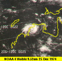


This was the satellite image they had to work with and little surface obs.
and this was the end result
Note the storm track here. It went from zero to Cat 4 in a very short space of time.
Therefore rapid intensification has always happened and given the lack of observations around and poor Satellite coverage or resolution in the 70s it is hard to get excited about a trend of rising major storm numbers. The period with the best observations 1990 onwards has no trend.
This whole thing reminds me of a guy who discovers a magnifying glass and “finds” thousands of tiny creatures the eye cannot see. And he finds more and more and more everywhere. Soon he’s analyzing hot air dryers in public restrooms and causing horrifying headlines about what comes out of those things and how terrifying this all is. Because now he can see the creatures…….
who would have think it…….CO2 can increase hurricanes without changing the temp
Any way you look at that chart of the global ACE supplied by pbweather it is clear that the total number of hurricanes correlates very well with the number of major hurricanes.
paulski, if you start at 1970, which obviously was the bottom of some cycle, there does seem to be a slight upward trend.
However if you start at 1972, there just as obviously a strong downward trend.
Why is 1970 a better start point than 1972?
pbweather
Sorry, this reply should be here, not above.
Thank you. As bad as I am at interpreting graphs, I don’t see much of an upward trend in that one. Perhaps a little until, as you point out, until the 90’s, since then, nothing. I’m also of the belief that until reliable satellite monitoring in the mid to late 70’s, hurricane monitoring was as much by luck as good judgement when ships ran into them or hurricane hunter aircraft found them.
So the data is,as usual, suspect and limited by the physical ability to find, and estimate hurricane strength until, probably, the early 80’s. And as I understand it, changes in the quality of data and changing measurement methods in satellites have also necessitated the homogenisation of results. Therefore the limited variation in this graph must be in question.
HotScot: “Now we’re being told that there will be fewer hurricanes, but they’ll grow faster?”
Indeed. And then “scientists” will look at historical data related to hurricane growth with the purpose of bringing previously-measured and reported rates of growth into line with current knowledge and methods. This, of course, will result in the need for the historical records to be “adjusted.” Isn’t that how it works?
I wonder how fast they formed five hundred years ago?
old white guy
Really……reeeaaaallllllyyyyyy slowly. 🙂
Scientists have been predicting for years that there would be fewer but stronger hurricanes. ?width=800&height=600&carousel=1
For example, from 2005: http://science.sciencemag.org/content/309/5742/1844.full (Jane Curry is one of the authors; someone here mentioned her)
One theory is that because hurricanes develop partly due to the difference between sea surface and tropospheric temperature, and since global warming heats the troposphere, the difference is lower, resulting in fewer hurricanes. So, it turns our climate change may be one driver in this case, too. Of course, AMOC apparently also has an effect. I don’t know if it’s addressed in these papers, but some scientists predict that AGW will have an effect on the AMOC, too (or it has already), through the accumulation of less dense freshwater from ice melt near the poles leading to slower sinking of cold water. (I imagine the 2016 Hansen et al. paper was posted here, discussing how the freshwater effect meant the models could be biased toward high sensitivity? That’s how I remember it, anyway).
You all know this, I think, but just a reminder to exercise caution in judging the researchers or the science based on a press release. We all know that PRs don’t necessarily represent the research perfectly or in full.
Kristi
Like I said, it’s a variation on a theme. Been saying something of the sort for the last 40 years.
Funny, the alarmists failed to predict the planet would green by 14% though.
“Please call me when you find the 1920s/30s/40s satellite data”…
Link: Climate Study: Conservatives Aren’t Insane, They’re Just Ignorant
https://wattsupwiththat.com/2018/05/07/climate-study-conservatives-arent-insane-theyre-just-ignorant/
Referring post currently in moderation.
1) “Consistent with other studies, the scientists did not find that rapid intensification is happening more often nowadays. But the scientists also looked closely at just how much the storms are strengthening. They found a sizeable jump in the strength of fast-growing storms – the storms are getting more powerful more quickly within a 24-hour period than they were 30 years ago.” This combination of statements just doesn’t stack up (at least, not without a lot more data and you have question the comprehensiveness of the data from 30 years ago).
2) “The team found that the biggest factor explaining the increasingly rapid intensification is the AMO. The result comes in part from analyses using 16 separate climate models to isolate the impact from global warming. This was a surprise, that the AMO seems to be a bigger influence in rapid intensification than other factors, including overall warming”. Colour me as equally unimpressed as I was with 1). Was the nature of this research actually to look at weather effects, or simply, yet again, to try to prove AGW and its catastrophic effects? Why be “surprised”? You’d only be “surprised” if you had a strong pre-conceived idea and you were seeking data to prove it.
3) (following on from 2) “teasing out the effects of the AMO from broader effects of global warming was beyond the scope of the current study” . Why? Surely that should have been the point – research the whole subject and draw conclusions based on the facts.
I wish I could make a living like this.
Ian Magness
You mean you”re not getting paid by big oil to post on WUWT?
Damn, I was hoping for recognition and a nice cheque through the post.
🙂
Scotty,
Sadly not.
In fact not paid by anyone.
🙁
As you probably guessed, what I really meant was “I wish I could write crap like this paper and be paid for it”. It would beat working.
Yup!
A pretty much insensible statement about a very limited data set with a short timeline of changing methodological assessments.
That’s how they achieve certainty in climate science. It would be laughable in any other field.
‘They found that a climate cycle known as the Atlantic Multidecadal Oscillation or AMO is central to the increasing intensification of hurricanes, broadly affecting conditions like sea temperature that are known to influence hurricanes.’
Not sure this has any actual meaning. ‘Central to’ means what? A correlation? A cause? Rapid intensification is caused by warm water, and AMO causes warmer water? ‘Conditions like?’ So they don’t really even know? Is the rapid intensification caused by warmer water that is caused by AMO or not? They try very hard not to actually say that, just to insinuate it in hopes that you think it.
As a scientist noted here on WUWT a couple of years ago, there’s always warm water in the Atlantic and Gulf in the summer. Every summer. With or without AMO.
So they discovered that hurricane formation and strengthening has a cycle, likely based on other natural cycles?
Yawn.
Was it predicted, and when, and by how much?
Seems a bit like the green jelly bean hypothesis to me. If you examined a whole bunch of statistics from every hurricane you be be bound to find at least one parameter that has changed in the last 30 years. Then all that remains to be done is blame it on global warming.
Not even “global warming” anymore, because it isn’t warming. We have actually arrived at the point where climate change is blamed on climate change.
“Rather, the phenomenon is strengthening more in the central and eastern Atlantic, especially to the east of the islands of the Lesser Antilles, which includes the Virgin Islands and Saint Kitts”
First of all, the Virgin Islands and St Kitts are the western border of the Atlantic Ocean so of course Atlantic storms must be east of them.
Second, how much of this phenomenon can be attributed to better satellite coverage with better details about the storm itself and more accurate estimates of wind speeds.
Tom in Florida May 9, 2018 at 5:04 am
“Rather, the phenomenon is strengthening more in the central and eastern Atlantic, especially to the east of the islands of the Lesser Antilles, which includes the Virgin Islands and Saint Kitts”
First of all, the Virgin Islands and St Kitts are the western border of the Atlantic Ocean so of course Atlantic storms must be east of them.
The accepted definition of the Atlantic ocean is that the western boundary is the American coastline.
I think this study generally agrees with the conclusions of Judith Curry, who knows probably more about hurricanes and their causes than anyone else. Global warming has little if anything to do with the number and strength of Atlantic hurricanes. https://judithcurry.com/2017/10/06/jc-interview-hurricanes-and-global-warming/
Scraft1
Dr Curry provided one of the most accurate forcasts for last year.
At the end of the season she stated that the mechanism for rapid intensification is not known. This study does not appear to provide any clarity. Sea surface temperatures are only one component, and not the key one for rapid intensification.
Regards
It couldn’t just be that we have better technology to keep track of the hurricanes development? 30 years ago we didn’t even know they were forming most of the time.
“This was a surprise, that the AMO seems to be a bigger influence in rapid intensification than other factors, including overall warming,” said Balaguru
And there you have it. Thankfully they were honest enough with the data to actually see the trend. Usually they succumb to confirmation bias.
For the uninitiated can someone provide in laymens terms more info on the AMO..how long are the cycles. Why does it get warm? What happens when it gets cold..I suspect this won’t be widely reported in the main stream press as it means the increased storm strength is related to something variable in nature and not alleged man made global warming…
Doesn’t the AMO cycle run for 60-70 years? Have they simply discovered the result of half a cycle?
This looks like the AMO, and the question is how the AMO is related, if at all, to AGW.
The question is, what AGW?
The AMO cycles and so will the hurricanes. What about the hurricanes od the last 150 years? Galveston, etc.
Their 30 year study is not significant with respect to time.
Their claims are alarmist, in spite of attribution.
A) They depend on a technology that has fielded huge leaps in capability over the period in question.
* 1) These researchers do not take into account improved technical ability or improved area coverage.
* 2) These researchers base their claims on a current dominant AMO cycle.
* 3) These researchers utterly fail to compare modern storms to historical storms.
B) Researcher utter failure to place storm development in historical context or to minimize technology change impacts on storm development data is a form of cherry picking.
C) Allowing these alleged researchers to declare an alarmist conclusion, then use recent high definition over older low definition technology as their proof mechanism.
I guess they are fortunate that you weren’t doing the peer review. Makes you wonder who did pretend to do it.
Even over the last thirty years we have improved our ability to monitor hurricane strength, especially via satellite. Often the peak strength of a hurricane is short-lived and catching that peak is difficult from aircraft reconnaissance. Therefore, over the last thirty years, we are better able to catch the top wind values after rapid intensification. That may play a factor in why RI seems to be resulting in higher peak values. Just sayin….
Sheri commented: “This whole thing reminds me of a guy who discovers a magnifying glass and “finds” thousands of tiny creatures the eye cannot see. And he finds more and more and more everywhere. Soon he’s analyzing hot air dryers in public restrooms and causing horrifying headlines about what comes out of those things and how terrifying this all is. Because now he can see the creatures”
+1, well said, deserves repeating.
They left out the 8th factor. Better and constant monitoring of the cane strength through advanced plane and satellite observations that did not exist 30 years ago…..
This whole study is garbage.
“The team found that the biggest factor explaining the increasingly rapid intensification is the AMO. The result comes in part from analyses using 16 separate climate models to isolate the impact from global warming.”
Later on they contradict themselves by saying
“Consistent with other studies, the scientists did not find that rapid intensification is happening more often nowadays.”
It is unbelievable how climate studies can be so much garbage and dont forget they are based on taxpayer money. See above post for proof.
What amazes me is that no one here seems to understand that this really is not about hurricanes. The 97% of “climate scientists” and the IPCC have left a whole lot of recurring natural cycles out of their climate change models due to the “difficulty” in including the variability of each (and the variability of the combined effects). If you look at AMO SST variation dating back to 1856 on an unsmoothed basis, the monthly temperature only varies cyclically by about +/- 0.5C over that time which is probably less than the statistical error based on instrument variability. Surprising? Not really. In any event, the fact that the author WAS “surprised” that the AMO played an important role is mind boggling – who are these people?. Leaving out the AMO (closer to a 30 year cycle – but variable), PDO, AO, SOI, NAO, ENSO and all of the other short term atmospheric and oceanic oscillations (yes 30 years is short-term) and which are constantly interacting with each other causing significant implications (like a negative AMO and PDO occuring at the same time) is like recognizing that it is cooler at night than it is during the day but saying that the observation is based on too many variables to be sure just yet. Lets add in oceanic circulation and overturning currents like the AMOC if you really want to blow their minds. If the authors are really climate scientists, this information should be part of their basic scientific body of knowledge. It’s like missing the forest for the trees, even if you don’t know what all of the different trees are – they still exist. Without these factors included, current climate (and sea-level rise) models are just not worth the data warehousing space they take up. We are slowly finding out all of the variables, both natural and instrumentation based, which have been overlooked. It’s just a matter of time before the entire house of cards collapses.
Well, I’m sure we can fix this by micromanaging humanity’s contribution to C02.
I wonder what the cost/results would be?
IIRC The algorithm used by satellites to calculate on-ground wind speed has been adjusted, resulting in higher values — values higher than recorded at actual on the ground wind stations.
If this is true, then of course the results of this paper is an artifact of this adjustment. No?
“Balaguru notes that teasing out the effects of the AMO from broader effects of global warming was beyond the scope of the current study but is a focus for scientists.”
Easy, AMO warming is normal during solar minima because low solar increases negative North Atlantic Oscillation states, driving a warmer AMO, and with increased El Nino episodes also driving warm AMO pulses. That’s why such intense hurricanes occurred in 1886 and 1893.
I have gone through the present article relating to hurricanes strengthening now than 30 years ago; and clouds and El Nino. The former is in AMO zone and the later is in PDO zone with around 60 year cycles but in opposite phases. That means, if PDO zone is in warmer phase then AMO must be in colder phase. But, both authors referred this as warmer phase.
Basically global average temperature anomalies and parts of it are adjusted data series. In such scenarios, in nature is it possible to get high correlations between this parameter with others? Not possible, as several factors interact the situation.
Hypothesis — thunderstorms cool the surface in part by increasing surface albedo; but in reality it is increasing [albedo and temperature presents a lag] and not cooling. Secondly, with high temperatures with high cloud tops [that means thick clouds], they both must not coincide at a point but must present a lag.
In the case of hurricanes – it says sea temperature influences hurricanes. The warmer the upper ocean, more powerful a hurricane can become. The AMO has generally been positive – causing warmer waters – since the late 1990s.
Wind speed going up is associated with the temperature gradient but not with higher temperatures.
In the Bay of Bengal, the occurrences of cyclonic storms in summer are very rare but they are more and powerful in post-monsoon [northeast monsoon] season [winter phase]. The cyclonic storms of the winter phase present 56 year cyclic pattern and southwest monsoon season cyclones also present 56 year cycle but in opposite phase similar to AMO and PDO.
The two presentations must look in to these aspects before coming with sensational conclusions.
Dr. S. Jeevananda Reddy
Thank you Dr. Reddy. I always read your posts with great interest.