From PRINCETON UNIVERSITY and the “it can’t be cyclic natural variation” department
How global warming is drying up the North American monsoon
New insights into the droughts and wildfires of the southwestern US and northwestern Mexico
Researchers have struggled to accurately model the changes to the abundant summer rains that sweep across the southwestern United States and northwestern Mexico, known to scientists as the “North American monsoon.”
In a report published Oct. 9 in the journal Nature Climate Change, a team of Princeton and National Oceanic and Atmospheric Administration (NOAA) researchers have applied a key factor in improving climate models – correcting for sea surface temperatures – to the monsoon.

The report’s authors include Salvatore Pascale, an associate research scholar in atmospheric and oceanic sciences (AOS); Tom Delworth, a lecturer in geosciences and AOS and research scientist at NOAA’s Geophysical Fluid Dynamics Laboratory (GFDL); Sarah Kapnick, a 2004 Princeton alumna and former AOS postdoc who is currently a research physical scientist at GFDL; AOS associate research scholar Hiroyuki Murakami; and Gabriel Vecchi, a professor of geosciences and the Princeton Environmental Institute.
When they corrected for persistent sea surface temperature (SST) biases and used higher-resolution data for the regional geography, the researchers created a model that accurately reflects current rainfall conditions and suggests that future changes could have significant consequences for regional water resources and hazards.
“This study represents fundamental science relating to the physics of the North American monsoon, but feeds back onto weather to climate predictions and building resiliency for our water supply and responses to hazards,” said Kapnick. “I am excited about this leap forward to improve our models and for the potential applications that they will provide in the future to society.”
Their results highlight the possibility of a strong precipitation reduction in the northern edge of the monsoon in response to warming, with consequences for regional water resources, agriculture and ecosystems.
“Monsoon rains are critical for the southwest U.S. and northwest Mexico, yet the fate of the North American monsoon is quite uncertain,” said Pascale, the lead author on the paper. “The future of the monsoon will have direct impacts on agriculture, on livelihoods.”
Previous general circulation models have suggested that the monsoons were simply shifting later, with decreased rains through July but increased precipitation in September and October.
“The consensus had been that global warming was delaying the monsoon … which is also what we found with the simulation if you didn’t correct the SST biases,” Pascale said. “Uncontrolled, the SST biases can considerably change the response. They can trick us, introducing artefacts that are not real.”
Once those biases were corrected for, the researchers discovered that the monsoon is not simply delayed, but that the total precipitation is facing a dramatic reduction.
That has significant implications for regional policymakers, explained Kapnick. “Water infrastructure projects take years to a decade to plan and build and can last decades. They require knowledge of future climate … to ensure water supply in dry years. We had known previously that other broadly used global models didn’t have a proper North American monsoon. This study addresses this need and highlights what we need to do to improve models for the North American monsoon and understanding water in the southwest.”
The new model also suggests that the region’s famous thunderstorms may become less common, as the decreased rain is associated with increased stability in the lower-to-middle troposphere and weakened atmospheric convection.
“The North American monsoon is also related to extreme precipitation events that can cause flash floods and loss of life,” Kapnick said. “Knowing when the monsoon will start and predicting when major events will happen can be used for early warnings and planning to avoid loss of life and property damage. This paper represents the first major step towards building better systems for predicting the monsoon rains.”
The researchers chose to tackle the region in part because previous, coarser-resolution models had shown that this area would be drying out, a prediction that has been borne out in the droughts and wildfires of recent years. But most of those droughts are attributed to the change in winter storms, said Pascale.
“The storm track is projected to shift northward, so these regions might get less rain in winter, but it was very uncertain what happens to the monsoon, which is the other contributor to the rains of the region. We didn’t know, and it’s crucial to know,” he said.
In their model, the researchers were able to tease out the impacts of one factor at a time, which allowed them to investigate and quantify the monsoon response to the doubling of atmospheric carbon dioxide, increased temperatures and other individual changes.
Pascale stressed the limits of this or any other climate model. “They need to be used with an understanding of their shortcomings and utilized to their expected potential but no further. They can give us quite reliable information about the large scale atmospheric circulation, but if you want to look at the regional, small-scale effects, you have to be very careful,” he said. “Models are critical but they are not perfect, and small imperfections can lead to big misunderstandings.”
He continued: “We are not saying, ‘We are sure that this is what will be,’ but we wanted to point out some mechanisms which are key, and have to be taken into account in future research on the North American monsoon. This is a difficult region, so future research will point out if we were right, and to what extent.”
###
The research was made possible by enhancements to NOAA’s research supercomputing capability including access to Gaea and Theia and by the NOAA CICS grant NA14OAR4320106.
Manuscript: Pascale, S., Boos, W. R., Bordoni, S., Delworth, T. L., Kapnick, S. B., Murakami, H., Vecchi, G. A., Zhang W. (2017): Weakening of the North American monsoon with global warming, Nature Climate Change, in press. Doi:10.1038/nclimate3412
The explorer Cabrilho who explored the California coast circa 1545 ad was surprised by the [sparsity] of natives – which was attributed to the lack of rainfall . This prediction of drought in ca must be something “New”
Obviously what is produced as “Concensus” climate science was/is wrong.
As for the last point, I was under the impression that climate was supposed to become more EXTREME as a result of climate change and not have “Increased Stability”.
Increased Stability sounds like another term for Fair Weather
Bryan – We are probably on the same page – My reading of the model is that the rain/monsoons are going to revert back to the norm experienced in the region over the last 1000-1200+ years. Though the climate scientists are claiming the revision to the norm is somehow new and dangerous.
Just what were these “biases” and how were they “corrected” for?
MarkW October 9, 2017 at 1:17 pm
Just what were these “biases” and how were they “corrected” for?
“Horizontal resolution is critical for adequately representing the NAM in models. It has been recently shown that GCMs with horizontal grid spacing coarser than 100 km (as most models participating in the Coupled Model Intercomparison Project, Phase 3 and 5, CMIP3 and CMIP5) do not accurately resolve the summertime low-level flow along the Gulf of California (GoC), with detrimental impacts on simulated precipitation in parts of the southwestern US
“To address these issues, here we investigate the response of the NAM to increased CO2 and its sensitivity to both horizontal resolution and SST biases with the high-resolution (0.5° × 0.5° in the land/atmosphere) Forecast-Oriented Low Ocean Resolution (FLOR) model19, 20, developed at the National Oceanic and Atmospheric Administration (NOAA) Geophysical Fluid Dynamics Laboratory (GFDL).”
Hope this helps.
Unprecedented even.
Is it not amazing that, when the “climate scientists” or whatever make the novel adjustments, correcting for things that might already be fine, always find the effects of global warming. The only cogent conclusion to all this is that adjustments cause global warming and it’s manmade, as the adjustments are manmade.
“Abundant summer rain”? Arizona, New Mexico, and northwest Mexico proper are rather dry generally, and if I recall correctly, have a long history and paleo record of extended droughts from a low baseline.
It is definitely in a different weather pattern than California generally, which has almost entirely winter rain.
Tom – as you stated – “have a long history and paleo record of extended droughts from a low baseline.”
Old Adage – ” you cant know where you are going if dont know where you’ve been ”
In this case the Climate Scientists – ignore 1000+ years of history of droughts to model something “new”
California East of the Coastal Ranges and, further North, the Sierra Nevada has Summer thunderstorms, but they rarely make it over to the coast because of the persistent if feeble in Summer westerly winds off the Pacific. And the area doesn’t get all that much rain. The town of Mojave averages about six inches (15cm) of rain a year — some from Summer thunderstorms, some from Winter frontal storms.
Is it any coincidence that the Anasazi left (died out) the area the same time that the Vikings froze (died out) in Greenland?
Maybe Princeton forgot about Oroville, CA?? Or perhaps what happened in Northern California didn’t constitute a monsoon???
The North American monsoon, variously known as the Southwest monsoon, the Mexican monsoon, the New Mexican monsoon, or the Arizona monsoon is a pattern of pronounced increase in thunderstorms and rainfall over large areas of the southwestern United States and northwestern Mexico, typically occurring between July and mid September. During the monsoon, thunderstorms are fueled by daytime heating and build up during the late afternoon-early evening. Typically, these storms dissipate by late night, and the next day starts out fair, with the cycle repeating daily. The monsoon typically loses its energy by mid-September when drier and cooler conditions are reestablished over the region.
The rain in Oroville was in February, not between July and September.
A reduction in Monsoon activity means fewer summer thunderstorms in the high Sierra which means that the snow will keep longer, there will be fewer wildfires and the permanent snow pack will grow. How is this an effect of warming?
Three comments:
1. “abundant summer rains that sweep across the southwestern United States and northwestern Mexico” – Since when? This area is shown on maps as the Sonoran Desert.
2. No mention of ENSO?
3. It’s models all of the way down.
+1
In 1980-81 I lived in Farmington NM (northwest NM). Then the average annual was 7.5″/year and the wettest month was August. Currently the average rainfall is 8.59″/year and the wettest month is August. This data doesn’t seem to support the author’s premise.
How dare you bring personal real observations to a theortetical future climate model discussion!!
just in case, /sarc now off.
The Monsoons brought the usual moisture to the Las Vegas Valley this year…
“In their model, the researchers were able to tease out the impacts of one factor at a time, which allowed them to investigate and quantify the monsoon response to the doubling of atmospheric carbon dioxide, increased temperatures and other individual changes.”
Interesting that they presume linearity, otherwise, the superposition of individual effects would be invalid.
Hmm. ‘Tease’… sort of reminds me of hairdo’s of the 1980s….
Unfortunately, there are no Anasazi folks around to reveal the true nature of extended temperate vs drought cycles.
following ten years or so of lackluster monsoons, Arizona has had two years of healthy monsoons. OF course the indians eight hundred years or so ago would be the first to agree with the “findings”.
Interesting that the monsoons have an official start date now, as opposed to previously, when the monsoon began when DEW points got high enough. Why the hard date decision?
As for predicting a monsoon storm, the same goes, if the dew point is high you can pretty much figure it’s going to rain, mix in some kind of outdoor event and it’s a lock.
Jeez, look out the window. Flash flooding took several lives this year all related to heavy monsoonal flow. It was humid where I live and that only happens…guess when.
And I’m not talking Pineapple Express, that’s different.
Good grief, the place is a desert. What do they expect to happen apart from crazy weather.
just like Australia, another desert with crazy weather that’s driven the all the weathermen there crazy – well, the BOM at least.
Only real hope is a big and direct meteor strike and or a volcano to lay down some fresh dirt and get a few plants growing there. Plants are more or less made of water and water attracts water, certainly across the atomic scale but I’d say the attraction works over hundreds if not 1000’s of miles
I’ve previously thought that, if ‘we’ got sufficient energy from somewhere (fusion or Thorium), we could use that to grind up a nearby mountain and spread that around. get some fertility back into the ground.
Seconds thoughts suggest it’s maybe not a good idea to put *that* much grunt into the hands of children.
We’d have to lose the ‘sugar habit’ that turns us all into easily-frightened, buck-passing and attention-seeking children.
At least amongst our leaders and their close advisers.
Desert soils are usually rather fertile. Just add water.
Australia is a special case since it was situated in the wet southern temperate zone and very thoroughly weathered for a couple of hundred million years before being transported north into the subtropical desert while remaining tectonically quiet all the time.
Australia needs either an ice-age or a lot of volcanoes or a new major mountain chain to become fertile again. Nothing less will do. Compare with New Guinea which has both a lot of young mountains and volcanoes and is very fertile (New Guinean forests being the only ones I know that are literally impenetrable)
I’ve driven across the New Mexico/Arizona desert several times–happened to be there once just after some rain. The entire desert was in full bloom, amazingly beautiful.
Australia is surrounded by volcano-rich neighbors in New Guinea, New Zealand and Indonesia. Maybe it could borrow some mountains and volcanoes.
Tty, a true story. Significant years ago, I took then wife, two kids, and the wife’s parents to Arizona for ‘spring break’ because I had been commuting to greater Phoenix AZ multiple days/week on then corporate business. So, ex wife was a rabid Cubs fan. We went to a preseason Cactus League Cubby training game game and go rained out fourth inning. We headed north to Flagstaff for the second part of spring break (Indian ruins, Meteor Crater) and got snowbound in the rental condo for two days by >8″ of the white stuff called snow that I paid lots to escape from Chicago. Pretty sure was just rotten weather.
Of course the place is a desert. From Wikipedia: “Bagdad holds the record for the longest dry streak in United States history with 767 straight days without rain, from October 3, 1912 to November 8, 1914.”
Bagdad is an extinct town on old Route 66 roughly half way between Barstow and Needles.
Remarkably enough all historical data show that monsoons grow stronger and extend further from the Equator in a warmer climate. But not this time around apparently….
Don’t previous “indigenous” populations move into during global warming and out of these Southwestern desert areas during global cooling? Anasazi come to mind. Also like Joe points out in 1545 when California first explored by Spanish was dry and depopulated in that area, which was during a period of Global Cooling? Wasn’t it? So if these monsoons have dried up as claimed, doesn’t that demonstrate we are cooling now, not warming, despite what NOAA and NASA claim with their “adjusted” land temperature data-sets?
If there’s gonna be no warming it’s all b..lls isn’t it?
Arrrrrrg! California always has massive fires after a winter with heavy rains, like this last winter. The rains cause all the non-native grasses to grow and grow big, then in all dries out in fall, and frequently catches fire. And because the rain caused so much more fire fuel to grow, the fires tend to be bigger. It has been this way since I was a kid.
Lack of Monsoon my butt, If we don’t want fires in California, we would figure out how to have perpetual droughts, so that the grasses do not grow.
Naw they just need to get off their Hillary Duffs and get those Air Tankers in the sky
CA is using the air tankers effectively, including the 747 super tanker right now, unlike Oregon and Washington states.
perhaps it’s a lamestream media thing. I’m in Santa Rosa (the air is just like Beijing only not quite so thick) and all day long, all I have heard on the news is “Where’s the air support”
It makes you wonder how the discovery of the PDO would have been handled, described, and named in the current political climate change control apparatus.
Somebody help me out here? Do these guys ever leave their offices and enjoy fresh air? Are they really living on this planet? Seriously, do they look at anything besides computer screens? Do they go into the field and check hydrometers and rain gauges, never mind measuring snow depths?
Less rain in winter??? Where were they last winter when the snow was falling nonstop in the Sierras? The snowpack depth was higher than it had been in several years. Ski resorts stayed open until the beginning of July. (I think it was July, or maybe mid-June.) The Biggest News Story Ever was that the prolonged drought that had whacked California for several years had finally broken.
I don’t live in California, but frankly, if I did, I would be more than annoyed by this article. I live in the Midwest. We had a cold, snowy December, followed quickly by a west, drizzly January and February and onward into May until I longed for sunshine and warm air. Then Irma the Hurricane showed up and altered the weather pattern, which changed the summer rains by means of an omega blocking high pressure pattern.
That old boogie man “climate change”, which is a pig in a poke if there ever was one, is not drying up the “North American monsoon”.
I don’t know where they are getting this stuff. They must like baloney a lot, because that is what they are trying to sell us.
Sara, that part of California is in a different weather pattern than central California. The far north is more like Oregon and the rest of the Pacific Northwest, the central part has a Mediterranean pattern, with winter rains and dry summers, and the inland part along with Arizona and New Mexico has what rain they have in the summer. The state is large and long enough to have a good many different climates.
No, they like spam. They like spam a lot.
Spam est 1937. Highest per capita consumption is in Hawaii. Most often the only meat available in WWII Great Britain. I like Spam I admit.
Also the USSR. Spam and other foodstuffs from the USA kept Soviet subjects alive during the war, as later did our wheat shipments in the 1970s and ’80s.
Outrageous that Stalin wouldn’t let our heavy bombers drop Spam on the starving people of besieged Leningrad.
Spam is a favorite of the people of Guam, also.
In CA we always get more fires after heavy winter rains cuz it.cause more grass.to.grow and when it dries in fall(we don’t get summer rain) it.is ripe for burning. Low rain years have less.fire actually.
I have to agree with one point that these researchers ? have made and that is the need for more water storage .If their predictions are wrong water storage still makes so much sense
Why are Greenpeace and the greens so much against dams for water storage for food production and urban supply.
Here in New Zealand they have gone to the High Court and blocked a dam project in the Hawkes Bay that would have supplied irrigation to a summer dry region and in Canterbury protesters have had to be forcibly removed from a storage lake that was being constructed to store snow melt to use for irrigation in the central plains .They have no idea where their food comes from and their actions are counter productive pushing an agenda that will only end up making people poorer.
They think their food comes from the store. They need an eye-opening experience in what it takes to stock grocery store shelves, and they need it now.
If it was bad when the Gulf of Mexico hurricanes were looming this time, think just how bad it would be where you are, gwan, if all the truckers who transport food products to grocery stores in New Zealand either could not deliver for a month, or worse, refused to deliver – went on strike – or the ships that deliver cargo containing preserved foods (canned goods) failed to show up. Think about what it would be like if it snowed so late in NZ that farmers simply could not plant wheat or whatever other grains they grow, or it was too cold for the fruit trees to blossom on time.
As you and I have both said,they all need a very serious, real-time lesson in the sources of what they take for granted.
You and i know better. We don’t take any of it for granted. I read the labels on the bagged vegs like potatoes (Wisconsin, Michigan), tomatoes (Mexico, California, Florida and sometimes Wisconsin), zucchini (Wisconsin, Indiana), and carrots (Florida, Wisconsin) and I take ZERO – ZIP – NOTHING – NONE of it for granted.
gwan, are the Greenbeans hyperventilating because they somehow think the quakes are caused by these dams? I know they aren’t. It’s just plate tectonics at work, but they don’t understand the Earth as an active planet at all.
Good to hear that the road is open again. Beautiful country, New Zealand.
“gwan October 9, 2017 at 1:11 pm
They have no idea where their food comes from…”
They also have no idea where most of their power comes from in New Zealand. Some form of dam.
“Sara October 9, 2017 at 1:50 pm”
NZ suffered a significant earth quake a few months ago and the main highways down south of Wellington on the mainland were blocked. In fact it was said they may never re-open. I am not sure the state of the situation in NZ now. I would imagine the highways are open again but I think that would have had a major impact on stores and supplies.
I remember that quake. I also wondered if the roads were going to take very long to repair. When/If they are major transportation arteries, they should be repaired unless the likelihood of more damaged to come makes it unfeasible.
I used to keep an eye on quakes in general. Up until the Christchurch quake, I had not seen much going on in New Zealand, and I believe the report was that the fault that slipped was unknown. I think that quake may have been a signal that there was more to come, because they seem to be repeating a lot.
The Kaikoura earthquake struck on the14th of September 2016 .This was an 7.8 quake on the Richter scale and destroyed State Highway One and the main trunk railway line on the east coast of the South Island .There was massive damage to the road and railway and it has only just been opened for traffic .This transport corridor runs along side the ocean beneath high cliffs and the railway has many tunnels . The destruction was almost complete but a great construction feat was undertaken and it is now back in service .An interesting part of the operation was the use of a fleet of helicopters with monsoon buckets sluicing the massive rock slides and slips into the sea .These debris were far to dangerous to shift with diggers because of the risk of the sliding material engulfing diggers and trucks ..A second class road was pressed into service and there were many lorry accidents as the road was never built to handle the large increase in traffic .
The greens are against dams for hydro power and some are agitating to destroy some dams to let the rivers run faster .The Waikato River in the North Island has eight Hydro dams and they have worked very well to supply cheap power and also for holding back water to reduce flooding in the lower Waikato .which was quite prevalent 30 to 60 years ago
“Corrected for Persistent SST biases (by putting in actuals?)…and higher resolution geography” the (reTuned ) model (finally) reproduced current rainfall patterns. Right. So by itself the model doesn’t do SST correctly and doesnt adequately resolve terrain (mountains) that influences convection hence Tstorms. Showing yet again how worthless climate models are. BTW, missing mountain topography is the norm in CMIP5, not the exception. The average width of the mighty Sierra Nevada mountain range is 60km. The finest resolution in CMIP5 is 110km, and the typical is 280km. The UK HadCM3 does not include the Andes (illustrated in esssay Models all the way Down) for similar reasons..
The problem of predicting future precipitation once you add mountains at higher regional resolution (introducting massive computational distortions thanks to the CFL condition for numerically solved partial differential equations) is predicting future SST. Since the model is admittedly biased, its future SST predictions cannot be corrected by putting in future SST observations. Logic fail. CFL uncertainty (different resolution regions forced to have different time steps). And no accountbof past natural variability. More ‘quality climate science’. NOT.
“Corrected for Persistent SST biases and higher resolution geography” I think the Simple English translation is “We had to change the Sea Surface Temperatures and stick some mountains into the model to get the answer we wanted to see.”
Suggest you read the paper, they are not using CMIP5 they are using high resolution.
“Horizontal resolution is critical for adequately representing the NAM in models. It has been recently shown that GCMs with horizontal grid spacing coarser than 100 km (as most models participating in the Coupled Model Intercomparison Project, Phase 3 and 5, CMIP3 and CMIP5) do not accurately resolve the summertime low-level flow along the Gulf of California (GoC), with detrimental impacts on simulated precipitation in parts of the southwestern US
“To address these issues, here we investigate the response of the NAM to increased CO2 and its sensitivity to both horizontal resolution and SST biases with the high-resolution (0.5° × 0.5° in the land/atmosphere) Forecast-Oriented Low Ocean Resolution (FLOR) model19, 20, developed at the National Oceanic and Atmospheric Administration (NOAA) Geophysical Fluid Dynamics Laboratory (GFDL).”
0.5° × 0.5° corresponds to approximately 55 × 48 km at 30°N latitude. This is considered to be high resolution?
They are modeling thunderstorm development, according to the blurb. Don’t thunderstorms happen at a scale of a kilometre or less?
The area of their map is 110° × 35°, which makes up 220 × 70 grid cells, times whatever number of vertical slices they divide the atmosphere into, Do they really need a supercomputer to model that size of a 3D grid?
The area of their map is 110° × 35°, which makes up 220 × 70 grid cells, times whatever number of vertical slices they divide the atmosphere into, Do they really need a supercomputer to model that size of a 3D grid?
Their model is global not regional and has a vertical resolution of 32 layers:
“Here we investigate the monsoon response to increased atmospheric carbon dioxide (CO2) concentrations using a 50-km-resolution global climate model which features a realistic representation of the monsoon climatology and its synoptic-scale variability”
But…but…but… http://www.climatecentral.org/news/warming-fueling-arizonas-monstrous-monsoons-21679
YOUR facts are confusing the issue. shame on you. 3 overly-cooked noodle slaps to the funny-bone
😎
I’m so sorry the conflicting claims of CAGW …er… “Climate Change” …er… “Weather Weirding” …er.. (Well, lets face it. There have been to many “…er…”‘s to enumerate here.) are confusing.
If everyone just forgot what they had said in the past then what they say in the present would be would be very clear. 😎
NOAA’s Climate at a Glance
https://www.ncdc.noaa.gov/cag/
has been down for the last several hours – their precipitation data as far as I know is OK so when it comes back up it will be easy to see if there’s been a trend that supports the above.
Yes indeed and then we can get comedian Zeke Hausfather to *adjust* the data until it fits the model.
“We are not saying, ‘We are sure that this is what will be,’ but we wanted to point out some mechanisms which are key, and have to be taken into account in future research on the North American monsoon. This is a difficult region, so future research will point out if we were right, and to what extent.”
Say what?
The only time these ‘researchers’ talk about reality, is when they suggest real people and real places need to use their imaginary scenarios to prepare for an imaginary future that they are convinced will be real. It is remarkable. There is no mention of the actual climate of the SW US and what it has done over time. There is no presentation showing that things are changing at all. They start with the assumption that human induced climate change will have an impact and that it will be bad. But the last sentence takes the cake! “…so future RESEARCH will point out if we were right, and to what extent.” Not Mother Nature. Not observations. Future research. You know…better computer models and simulations.
Well…I can tell them right now that they are wrong. If tweaking minor imaginary variables in their imaginary world gives them significantly different results, what will adding a huge chunk of reality, that they continuosly ignore, do to their delicate little computer game? Natural climate variability is almost completely absent from their models, and all real evidence continous to show that natural climate variability is greater than human impacts. It’s a joke!
If they did have a better understanding of the complex natural cycles that drive Earth’s climate, they might have a small chance of getting close, but right now they have no chance at all of making an accurate prediction of the future climate of the Southwest US. None!
+10
Climate at a glance is still down. I expect they closed up shop for the day.
I’ve lived here in Colorado since the 1990s and haven’t noticed any reduction in monsoon intensity or duration. If anything there’s been a slight tendency toward heavier precipitation events in recent years. Also, wouldn’t it make more sense that in a warmer world the hydrological cycle would be enhanced? Wasn’t the last glacial period much drier?
Yes. Colder is drier.
***this 10pm quote is all over the MSM. any ideas why this would be?
9 Oct: Sacramento Bee: Homes and businesses burn as fire rips through Santa Rosa. One confirmed dead in Mendocino
By Ryan Lillis, Molly Sullivan, Tony Bizjak and Benjy Egel
Gov. Jerry Brown has declared a state of emergency in Napa, Sonoma and Yuba counties, where wind-whipped fires have destroyed at least 1,500 structures, including many homes and businesses in Santa Rosa, and forced more than 20,000 people to evacuate their neighborhoods…
***Most of the fires started at about 10 p.m. Sunday and their causes are under investigation, officials said…
http://www.sacbee.com/news/state/california/fires/article177823806.html
saw a comment on one website, saying –
Some of these fires are separated by over 100 miles, yet they started about the same time.
No clouds. No lightening. Just winds sustained at 30-40mph with gusts to 70. Relative humidity was hovering below 20%…
Sounds like co-ordinate arson to me.
“Researchers have struggled to accurately model …””
The only interesting thing they had to say. Their models are worthless junk. End of story. Cut off their funding.
Improved models by correcting sea surface temperatures – hmm, so Karlization of SSTs made the models work better, doing double duty killing the “Pause” (which will be back this winter.) The quality of papers on Climate Change these days seem to have a pleading character, as if they know nobody is paying attention anymore.
The puniness of the issues they raise: Gee western Mexico is no longer a Garden of Eden, they got all these cactuses. Global warming caused margaritas. Where in hell did cactuses come from? Coconuts, I get.
In the snowball earth article PIK adjusted geologic time by 400million years to rearrange the coal ages (Carboniferous) to jibe with snowball earth. I think they used BEST methodology to homogenized it and pasteurized it but don’t quote me on it.
As always ….. let’s wait 20 years and see just how reliable these new adjustments are. Someone, please bookmark, scan the artical and any graphs for future comparisons …… and of course, future blink graphs showing now and then.
It is quite easy to model the past. With enough variables, there will always be SOMETHING that correlates. An example is sports teams and presidential elections. There will always be some league of some sort somewhere that correlates quite well with the winning presidential election party.
Though, as Yogi said: “It’s tough to make predictions, especially about the future.”
I’m just going to drop this here. It’s an article about a “nonprofit” (meaning grant-money-swallowing) organization telling us how “climate change” is costing the US $240 billion a year in damages. Um, no – damage to personal is usually paid for by homeowners and national flood insurance, which costs the US nothing, so that’s a completely bogus claim.
The chart included with the article is bogus, also, because the third column (green) covers only the 2007-2017 period instead of the first 10 years of the 21st century. That’s not how you do those things. But let’s not quibble over the fact that it’s another ‘gimme-gimme-gimme’ for grant money. Let’s just have some fun with it, right?
Here’s the link. It’s from Accuweather.
https://www.accuweather.com/en/weather-news/study-human-induced-climate-change-costs-us-economy-240b-per-year/70002906
The local Tucson U of A data over the last 67 years at Tucson International Airport doesn’t seem to show much of a trend either way –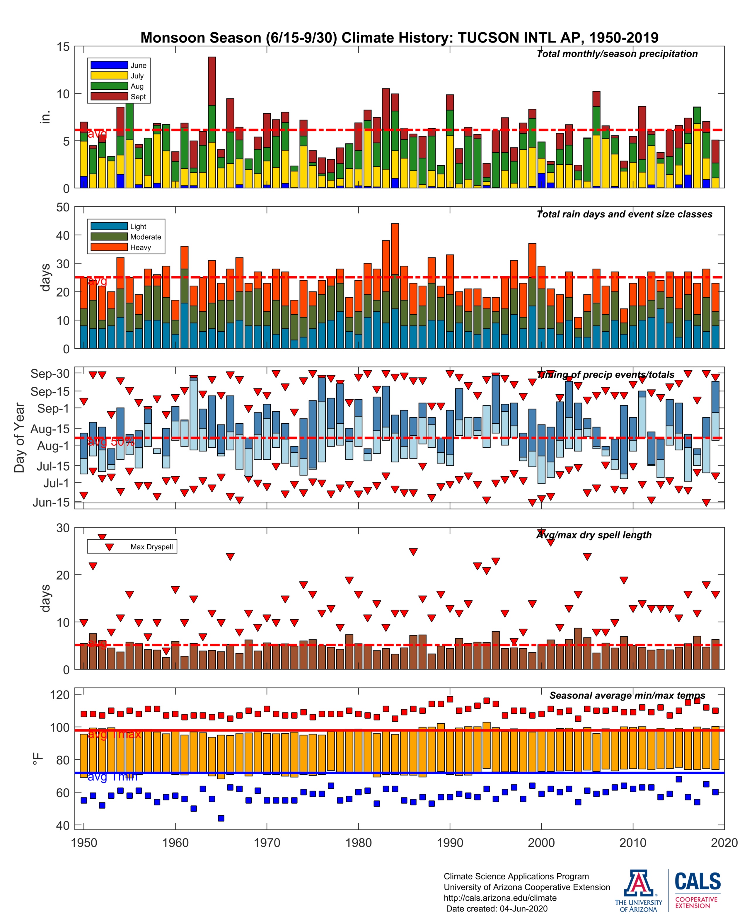
Perhaps their data needs adjustment to suit the model?
I just want one question answered “what caused all the climate change through out earth’s history?” We had climate change before man I quess Dino farts ruined the enviroment.
SST biases. How much in grant money is that worth?
The water pools that generate the vast amounts of water vapor are mobile, they move with the ocean cycles. It appears as they move back and forth across the equator, and they are currently north of the equator, and when they return to the south, the latitude where the atm rivers point will move south along with the warm pools.
This is all that’s happening. Because air responds differently over land, and land is not symmetrical, global average temperatures vary with the cycles.
In the American Southwest, there are two rainy seasons: the summer monsoon when the storm patterns are tropical—high humidity that builds up into thunderheads and rain; and the winter rains pushed by continental weather fronts, like the summer rains in the Midwest. Between those two weather patterns there’s a dry buffer zone of dryness where it doesn’t rain.
In southern Arizona one can see the changes over the seasons: winter rains, then in the spring dry, dry, dry with no rains, summer from mid June to end of September summer monsoon, fall again dry, dry, dry with no rain, as the pattern moves north and south with the seasons.
Unfortunately, winter is too cool for growing crops, so an increase of winter rains won’t help agriculture.
Knowing this pattern, what should we expect with global warming? With global cooling? Will the pattern move north or south with global warming? With global cooling?
This past year in Tucson, Arizona, the winter rains lasted longer than normal, then came dryness so bad that even some cacti died, the summer monsoon came late but ended two months early, and now there’s the fall dryness. Is this the pattern expected with global warming, or global cooling?
I’ve looked at the various station in the US SW.
This is the averages of the day to day min and max temp change by year.
This is also about regional weather variability. Not global climate change, in which the USA is a small and self obsessed part. Just pointing out the science fact. Statistically relevant climate change occurs over several insignificant human lifetimes.