And it keeps getting worse. Earlier we said the “worst case scenario” was likely to happen, now that includes a delayed turn keeping Irma over the warm waters of the Gulf longer.
https://twitter.com/RyanMaue/status/906400279653965824
The warm water in the Gulf is going to keep the beast known as Irma, fueled and fast:
https://twitter.com/RyanMaue/status/906397985206145025
Maue adds:
https://twitter.com/RyanMaue/status/906403238341169152
I see there are three hurricanes present in the area. Do they ever combine to make something even worse?
I cannot recall then so doing at hurricane strength. Anthony would probably know. Once they get to us (UK) up in the temperate zones its not uncommon to see low pressure areas coalesce
Even the models indicate that as Irma turns north, it will force Jose to turn northeastern Roth in response. Since both storms turn counter clockwise they may tend to bump rather than merge. If they spun like egg beaters, they could fuel each other.
Oh, here is more info that googling revealed
https://en.wikipedia.org/wiki/Fujiwhara_effect
Apparently they can.
Katia has just about fizzled out. Jose is far behind and will probably turn north to disipate in open waters.
I’ve seen them combine a few times, but I can’t imagine them being additive in terms of power.
Surely all those expert climate scientists, having spent $billions, have some geoengineering solution up their sleeves and ready to go.
Otherwise, what have they wasted those £billions on?
I met a classic conspiracy theorist at a festival in the UK recently. He truly believed that the US had some sound of sound machines that could engineer Hurricanes, there is, believe it or not, a patent for such a device. He was an old hippie who also believed that solar power generation was wrong because we were ‘raping the sun’ and preventing natural use of it’s blessings on the earth.
Just goes to show that the crazies are on all sides of the argument.
Drop a nuke down the eye and see what happens
nothing, energy differential between hurricane and a nuke is a drop in the bucket.
If the nuke isn’t affecting the hurricane, you’re just not using a big enough nuke.
There could be some side effects, though.
Yeah, how would that work?
Caller: “NOAA, Help! A hurricane is destroying my house!”
NOAA: Drops nuke on your house.
Caller: “Thanks!”
A nuke in the eye could increase updraft and potentially make things worse. But off to the side could create wind shear and disrupt the circulation.
Great plan Leo, if you want to cover FLA in nulear fallout as well as storm damage. :eyeroll:
Maybe iffen a few nukes or MOABs were detonated at a depth of 100/300 feet at the front or leading edge of the hurricane when it was in mid-Atlantic ….. it would have caused the cold deep waters to mix with the surface waters, …… thus cutting off the “fuel” that powers hurricane winds.
Please send the check for my Grant money to POB 645.
Eritas
Only thing that could disrupt hurricane is a major earthquake.
Katia hurricane got killed stone dead
http://www.trbimg.com/img-59b31914/turbine/ct-hurricanes-irma-jose-katia-20170908-001/750/750×422
got killed stone dead by the Mexican earthquake on the other side
https://www.google.com/maps/d/thumbnail?mid=1nv-YGg28z-qtd0zJvqPcf4TGGjw&hl=en-GB&gl=uk
It’s worth a try!
Dropping a nuke into a hurricane is like a Sharknado scenario.
Now you have a slightly less strong hurricane bringing in radioactive fall-out.
How about we take all of the wind turbines we have and turn them into giant fans a blow hurricane away.
A fleet of large cargo planes dropping planeloads of aerogel particles into it, at strategically located spots might though.
Do you work for the government? 😋
I think one side effect would be that the water remains warm instead of being cooled, so the next one will be stronger.
The air in the eye is sinking, not rising.
The air in the eye is the lowest pressure and is rising.
More images from NASA
https://twitter.com/NASA_SPoRT?ref_src=twsrc%5Egoogle%7Ctwcamp%5Eserp%7Ctwgr%5Eauthor
Many years ago, I guess the 1960s during the time of atmospheric nuclear testing, I recall a suggestion that exploding a suitably sized nuclear bomb within or near a hurricane/cyclone could prevent its further development. Presumably by introducing sufficient wind shear to disrupt its circulation. If the tropical wave in the eastern Atlantic is going to continue spinning off these things is it really too outlandish to discuss this suggestion again?
You’ve really given this a lot of thought, haven’t you?
Hurricanes dissipate heat energy from the ocean to the upper atmosphere. You really want to add MORE energy the system? But suppose that a hurricane could be disrupted; isn’t it very plausible another one would just spin up to replace it?
Piers Corbyn was predicting that the track would be more to the East than earlier estimates. He may rue putting that on twitter.
Piers Corbyn is about as useful as the North American Model.
https://twitter.com/islivingston/status/906377986290614272
Piers Corbyn sounds like a cockney ‘barra boy’ flogging dodgy Rolox watches … except that he’s not flogging watches.
I admire the combination of Rolex and bollocks. Neatly done.
Are we sure they aren’t mixing Jose up with Irma?
They’d better start evacuating New Orleans.
…..And raise the alert level for Biloxi, Mobile and Pensacola as a precaution…..It appears that Irma may not have gotten the same script as the “prognosticators”.
Looking at the charts, Florida is going to take a real pasting, and it will be a real test of flood defences and building regulations, as well as the emergency services.
Irrelevant flights of fancy
==================
Should the Alligator be the new poster boy of ‘weather change’?
I was amused to note that an increase in alligator attacks was being blamed on ‘global warming;’ rather than an eco policy of ‘dont shoot the murderous bar stewards and make handbags out of them’ policy.
Anyone remember ‘Day of the Triffids’?
I imagine wild sentient alligators stalking the flooded streets of downtown Miami puncturing inflatables with their pointy teeth.
Alligatornado it is!
Is this not the best news there is for the coastal areas? Will the storm surge not be a lot weaker?
Yes.
The surge risk will be very small..
Hurricane season in the Atlantic is still ongoing. Circulation on the equator and the Atlantic is conducive to the formation of hurricanes.
ren, I’m a little lost why you post Nino3.4 SST in relation to formation of Atl hurricanes.
“The El Niño effect
ENSO has been known to be one of the primary drivers of seasonal Atlantic hurricane activity since Dr. Gray published his classic papers on El Niño and Atlantic seasonal hurricane prediction in 1984. El Niño can create conditions that are unfavorable for Atlantic hurricanes. When the atmosphere over the tropical Pacific responds to El Niño’s warmer-than-average surface waters, the Walker Circulation weakens and shifts eastward. This increases upper-level westerly winds and levels of vertical wind shear (the change in the wind direction with height) over the Atlantic basin. On the other hand, La Niña conditions are associated with weaker upper-level westerly winds and reduced levels of vertical wind shear over the Atlantic basin.”
https://www.climate.gov/news-features/blogs/enso/how-have-changing-enso-forecasts-impacted-atlantic-seasonal-hurricane
Ren, thanks, very informative.
Thanks, ren.
El Ninos generally cause a warmer atmosphere but suppress hurricane formation in the way that Grey described whereas La Nina is associated with the opposite. That explains the lack of hurricanes during the recent warming period and the apparent increase now. AGW theory cannot explain the dearth of hurricanes over recent years.
Unfortunately for the alarmists the truth is the opposite of their scenario. Storms around the world are worse when the globe is cooling because of the increase in temperature differentials between equator and poles.
As I have said many times, solar variations alter the gradient of tropopause height between equator and poles.
When the sun is active that height rises at the poles but falls at the equator so that there is less height available for powerful hurricanes to develop.
When the sun is less active that height falls at the poles but rises at the equator so that there is more height available for powerful hurricanes to develop.
This run of vigorous hurricanes is a sign of the coming cooling not of the past warming.
Bear in mind that these storms are transferring vast amounts of energy from sea surface to space and will leave cooler sea surfaces in their wake. Whilst the sun is quiet, leading to more wavy jets and increased global cloudiness that lost energy will not be quickly replaced.
It’s not the El Niño but the fact that the east-west Trade Winds in the tropics tend to slow down. It starts in the Pacific and then tends to work back to the Atlantic. This allows hurricanes to move a little slower and build up more energy.
This impact takes time (months) and it takes a large event to impact the Atlantic as well. A large El Niño would have to start forming in May for example for this effect to be evident.
Thanks ren.
S Wilde: “That explains the lack of hurricanes during the recent warming period and the apparent increase now. ”
Not really since the ‘dearth” started after 2005 and even if you count the recent warming as far back as the previous low in 2011 it only matches the latter half of the dearth, therefore it can not be claimed to explain it.
Nothing in weather and climate is that straightforward because the interaction between the various ocean cycles heavily modifies the system response.
One can only refer to general trends across decades.
Also there has been a distinct absence of La Nina conditions following the recent Nino.
Bill Illis
http://www.cpc.noaa.gov/products/analysis_monitoring/enso_update/heat-last-year.gif
ren, these kind of values in the Eq. Upper Ocean Heat Anomaly are basically neutral numbers. They need to be more than double these amounts to signal El Nino or La Nina conditions. The right column here are the monthly numbers back to 1979.
http://www.cpc.ncep.noaa.gov/products/analysis_monitoring/ocean/index/heat_content_index.txt
Lack of wind shear is the critical factor.
It determines whether they form or not, persist or not, strengthen or not…wind shear cuts them in half.
Cuban coast seems to be making a good job of disrupting the structure of the storm. Will it reform and reorganise once it gets into the Gulf?
http://tropic.ssec.wisc.edu/real-time/mtpw2/product.php?color_type=tpw_nrl_colors&prod=natl×pan=24hrs&anim=html5
http://www.ssd.noaa.gov/goes/east/natl/h5-loop-rb.html
Oh man. WUWT filters going silly again, disappearing comments. Let’s try it piecewise:
http://tropic.ssec.wisc.edu/real-time/mtpw2/product.php?color_type=tpw_nrl_colors&prod=natl×pan=24hrs&anim=html5
Well, that explains the odd increase in wind speed. All the way across the Atlantic the wind speed never increased,only decreased 35MPH, until it approached Cuba. I didn’t realize that this meant is was getting tino warmer waters. And slowing down forward speed almost never is a good thing – look at Harvey. Originally the projected wind speed at landfall was 145MPH. Now it will be higher, perhaps significantly so.
What?
Have you looked at the satellite pictures of it?
It does not even have a close eyewall anymore.
I am glad they had the honesty to admit is has weakened greatly, just publishing new max winds as 130.
It is still moving due west, mostly.
At 8:00 PM last night, it was at lat 22.2 North, and at 8:00 AM it is at 22.6 North, and still moving West at 12.
The Weather Channel, who someone said always tells it like it is, is now calling 130 mph a cat 4.
The center of the NCAR forecast cone in now off the west coast with a landfall not until after 8:00 PM Sunday, and occurring at roughly…Punta Gorda!
But it is still actually going West.
Hey, all these guys are so sure it is impossible for them to be wrong…if they were maybe gonna be wrong they would only be kinda of sure.
There are a lot of people who really need to get a grip and get some semblance of being relaters of information back into their heads. The have come to believe they are oracles…if they think it strongly, it is a fact that has not occurred yet but soon will.
This is called alarmism.
I am seeing a micro version of the entire warmista pathology here.
Right down to somehow blaming people who do not take to getting bossed around by smug pricks for everything bad.
Oh, forgot:
http://www.rap.ucar.edu/hurricanes/realtime/plots/northatlantic/2017/al112017/intensity_late_stream15/aal11_2017090900_intensity_late_stream15.png
Crap, sorry, wrong darn link:
http://www.nhc.noaa.gov/storm_graphics/AT11/AL112017_5day_cone_with_line_and_wind.png
“But it is still actually going West.”
Yes exactly. I am getting so fed up of the mantra “heading for US mainland”, ” heading for Florida “, “heading for Miami” …. when there is not the slightest indication of a northwards turn yet.
The only thing heading towards Florida is the predicted track , not the storm !
It’s currently expending itself on the poor folks on the island of Cuba.
“It’s currently expending itself on the poor folks on the island of Cuba.”
I’m confused. Is “poor folks” metaphorical (due to the beating), literal (due to their economy) or both, making a pun?
SR
“Eastern Gulf of Mexico ocean temperatures (SST) are bath water just like Straits of Florida. ”
Well it missed the really warm water pool that is was supposed to run through had it headed up the east coast as all the models were predicting.
“Trip over Cuba — longer than expected”
Longer than expected as in we never expected to go there at all 😉
I am pretty sure all that water is very warm.
It is, but a good 1.5 degrees C cooler than where it “should” have gone had it turned as expected.
Times such as this when I really come to appreciate the ‘boring’ UK climate.
Best wishes to all in its path.
Climate Central (warmista website) produced a horrifying animation what they consider might happen to Miami. I do hope they are wrong.
https://youtu.be/Ys0nGDN06xE
Well that is just a photoshop water level trick. There is NO storm damage whatsoever, so it most certainly is wrong.
At least all the trees are still standing.
Trees are still standing.
Showing complete houses under water and water levels up to second story windows leads me to call BS on this “simulation.” It would be more accurate to call it an “imagination” I think. As far as I know, Miami is not located 20 feet below sea level.
All of the focus has been on Miami and the Atlantic coast (as regards evacuations etc.). Now it seems like they will only get TS winds and it is the Gulf coast that will get the worst. I hope they have prepared in Tampa as much as in Miami.
IIRC Tampa hasn’t had a hurricane since the early 1900s. Where I am in South Florida we’re kind of used to them, but Tampa may get some unwelcome experience with them also now.
Oh good ! That will make it “unprecedented”,
As of now, there is a bit of a scramble on the west coast of the peninsula. Storm surge will be awful. They just increased mandatory evacuation to Zone B in Pinnellas county. The worst case Tampa Bay scenario seems almost certain now.
Anybody seen Hurricane Katia?
What webpage can you go to to get actual wind measurements for Irma and Jose. If I DuckDuckGo Irma wind speed all I get is projections, not real measurements.
It is hard to find ground based readings.
Does anyone have expertise on measuring history of hurricanes?
We appear to have gone from ground based anemonitors to, about 1950s, flying into storms, to satellites with various instruments for each of the three methods. I have found out the plane readings we get are based on 10 sec duration, not the one minute sustained as in the ground based 10 m readings. I do not know the duration of the dropsondes also delivered from hurricane flights. I do not know how the recording instruments have changed.
All of this leaves one very large question as to how to, for example, compare the labor day hurricane some 82 years ago to Irma, or Harvey; which on ground based only readings was likely a CAT 2. Or how to compare modern “ACE” measurements to past active seasons.
It appears likely that past tropical systems were underestimated relative to today, and possible that even 1970s and later systems and events were under sampled and recorded relative to today’s 24 -7 monitoring and computer analysis. Yet with billions spent on CAGW research, this has not been done. ( Leif S did this with sunspots, but I guess we cannot do this now as the answers don’t fit the narrative)
ACE goes back that far
The data from 1860 to present has NOT been collected the same way. Given the huge changes in measurement and observation techniques over the last 150 years, I don’t see how that ACE chart has any validity at all.
Same questions I started asking earlier this week. This paper covers a lot of information in regards to how the measurements have changed. http://www.aoml.noaa.gov/hrd/Uhlhorn/MWR2007Uhlhorn.pdf
Bottom line is prior to 2005 intensity based on flight level readings was most likely underestimated by as much as 10%.
I looked up the raw data for Andrew last night and the peak wind measured at flight level was 165 mph. Boundary layer model in use at the time would have produced 130 mph winds at surface.
Changes to the radar and correlation with dropsondes implemented in 2005 would process that raw reading to infer 145 mph winds at surface which matches with the ground based anemometer at Turkey Point that measured sustained wind at 145 mph during impact.
Most recent raw data for flight into Irmas eyewall can be found at:
I don’t see how that ACE chart has any validity at all.
The caveats about the early data are discussed in my article from which that graph comes.
https://judithcurry.com/2016/01/11/ace-in-the-hole/
My comment was is relation to someone enquiring about relating ACE to wind-speeds 80 back , not 1860.
Greg and FL, both comments are cogent.
Regarding the JC link I did a read through. So far yes, some caveats are there, but I do not see any adjustments based on methodology of analysis; just adjustments of dubious SST data and modeling to results based on that. However, and scientifically not forgiveable, ZERO error bars on historical ACE products!
Katia’s done:
https://earth.nullschool.net/#current/wind/isobaric/500hPa/orthographic=-78.92,26.27,1712/loc=-68.630,36.678
nullschoolearth has surface windspeed
interesting they also dont show the speeds stated elsewhere on the cyclone itself
Katias pretty much fizzled as it hit mexico from what i saw at nullschool page some hrs ago
Beach webcam at Fort Lauderdale (hometown of Rud Istvan) shows things are getting breezy. As it happens my brother is just 3-4 miles to the west, decided to sit it out in a solidly built (concrete structure) apartment block.
‘Latitude’ another of the WUWT regulars lives in the Plantation Key area, hopefully evacuated safely. traffic webcam (click to refresh) shows area completely deserted.
Fort Lauderdale also, Coconut Creek area. Breezy, overcast, boarded up and waiting to see if we’re all dressed up but maybe the party went west…
Yes, winds are already above 30. Swells building. Reef is being pounded. No rain bands yet. Amazing given the eye is over northern edge of Cuba, 200 miles away.
another beach web cam in front of an apartment block, near jetty at Fort L. shows what it looks like a ‘nutty’ TV crew setting up lighting gear for a late night shooting.
Windjammer is in Lauderdale by the Sea about a mile north of us. Shows what we are experiencing. No rain for a few more hours, winds not yet sustained TS force although we have had a few such gusts. Zero palm tree damage so far. Will probably get some tomorrow.
Hurricane Jose on Lesser Antilles.
http://www.ssd.noaa.gov/PS/TROP/floaters/12L/flash-vis-long.html
Irma’s eye is approaching Santa Clara in Cuba.
http://files.tinypic.pl/i/00931/u0zbytcqurd4.png
Yes, the compact structure of the core seems to have reduced in size dramatically since it has been expending itself on Cuba. TPW has dropped markedly too.
Luckily Trump has just signed a memo banning export of US-made hurricanes to Cuba, so I’m sure they will happy about that.
Snap out of it!
The storm is not worse than anticipated. It declined to take the most destructive path. That was directly hitting the Florida East coast urban metroplex, and then into the Carolinas and up the eastern seaboard chain of hufe urban centers.
It is weakening over Cuba. It is likely to lose some of its organization before getting to the warm waters of the Gulf.
This Cuban excursion was not on the predictions at all.
This storm is not some angry Disney-esque conscious punishment for CO2.
It is just anorher storm. Nor was Harvey a punishment for CO2. These are all just storms that cause a lot of trouble for a lot of people. They have occurred since physics began.
But let’s stop the human double of anthropomorphic projection, assigning human attributes to movement of air, flow of water, and the skies above
We are humans, the toughest animals on this planet.
We will weather Irma, fix what is broken and learn to have fewer things break in the future.
Just say no to the hype.🚫
“This Cuban excursion was not on the predictions at all.”
Really?
At 12z on the 9th it was tracking along the northern coast of Cuba.
You do know where Cuba is on this forecast track spaghetti … from 5 days ago!
Pretty much smack in the centre of the projected trajectories.
Yeah Tone…the models have shown everything and a Caesar Salad over the past week, but the official forecast cones have said no such thing.
Model runs and spaghetti strands are not forecasts! They are not predictions. If they were, no one would pay any attention…predicting everything predicts nothing.
Hey, about that Arctic Sea Ice bet…
post hoc bias selection Tony. Since some models like NHC has been wobbling considerably you can always find something which has some tracks in the right area post hoc.

You are correct that ” …. not on the predictions at all.” is not strictly true.
The cone narrowed down after that to the east coast of Florida.
Miami was bullseye, etc.
It was going to be cat 5 on the east coast.
That is not what is happening.
Now apparently drier air is being incorporated into the circulation.
That will further weaken this storm.
“post hoc bias selection Tony”
No, just re-posting what the resident expert here himself posted here 5 days ago.
Take it up with him.
Agree. Doesn’t look to me like Irma is fueling up, just the opposite.
Irma is smacking right into high pressure cold winds that are trending southwest. Overnight she traveled almost due west, wind speeds died down significantly to low Category 4 or high Category 3, and internal temperatures of Irma cooled. For current wind patterns and to see how stark the cold front is along the west coast, see: https://earth.nullschool.net/#current/wind/surface/level/orthographic=-90.47,30.30,1263/loc=-78.725,22.803
(to bring up the legend, click of “Earth” in the left corner). Note that the little hurricane that was threatening the east coast of Mexico has disappeared.
For Irma’s track in the last 12 hours, see:
http://www.ssd.noaa.gov/PS/TROP/floaters/11L/html5-vis-short.html
The NHC is being kind of quiet about this, probably not wanting to give hope and end up with egg on their face. Still early, but I’m going out on a limb to say that it looks to me like Irma will continue west, or even southwest, or maybe stall out over Cuba, and will not hit Florida. My guess vs the NHC’s models. I’m often wrong, but never in doubt.
This is really unbelievable.
The models have failed, epically and millions have been inconvenienced and the economy of the entire state disrupted.
And yet at this point Maue is confident that this last projection is the one that will be right.
Is he saying what it sounds like he is saying… a landfall in Tampa will cause hurricane force winds all the way down the southeast coast?
Landfall delayed?
He seems to be stating a landfall near Tampa at a certain time of day is inevitable and should be treated as a fact which has simply not occurred yet.
No hint of the uncertainty, not wondering why those models have been incredibly wrong and the forecasters and politicians and MSM shills so incredibly shrill in their alarmism.
Crossing from Climate to Weather but keeping the alarmist pathology intact
I am not saying do not raise the red flag, but people communicating to the public or to anyone else about something as uncertain as weather forecasting should be obligated to make the uncertainties understood, not pretend there are none even as forecasts drastically change!
“….not wondering why those models have been incredibly wrong”
From 4th Sept…..
http://www.cubaweather.org/images/weather-photos/large/174243_5day_cone_no_line_and_wind.png
Toneb September 9, 2017 at 10:02 am
It’s child’s play to predict the path of Atlantic hurricanes while in the ocean. What separates the adult models from the kids’ is when storms pass Cuba and near Florida. Then it’s anyone’s guess. They can recurve sharply east, back out to sea, keep on going straight into the Gulf (like Andrew) or make a right turn and head over Florida. Less often do they make a left turn into the Caribbean.
And then, what separates the skilled adults from the amateurs is whether, having turned right, the eye of the storm will pass directly over the center of the peninsula, or skirt its Atlantic or Gulf coasts.
And then where it will go over land to the north.
“They can recurve sharply east, back out to sea, keep on going straight into the Gulf (like Andrew) or make a right turn and head over Florida. Less often do they make a left turn into the Caribbean.”
Not the under current upper wind flow they cant.
That is the steering mechanism.
“Snap out of it…
Just say no to hype…”
Glad a few of us are staying sane, although I confess for a little while there I was treating those cones of uncertainty as glimpses into the future rather than guesses of yet to be determined accuracy.
Hunter, the stronger north eastern side of the storm sliding up the western coast of Florida after likely slowing down and reforming in 88 degree open water is NOT an improvement.
The storm is now onshore in Cuba and showing no sign of the much ballyhooed northern turn.
And yes, the storm, if it does not simply head straight west-Southwest into Central America and actually does go up the Florida west coast is in fact much better than going up the east coast.
No gulf stream, no East coast cities, and far fewer people impacted.
The appetite for apocalypse and doom exhibited here some, but dominating elsewhere, is unhealthy.
The difference in the strong and weak sides is about 30 mph and significant surge variation as well.
Time will tell how it pans out…
Strike! Bonus ball!
http://www.gardengames.ie/blog/wp-content/uploads/2015/05/garden-skittles.jpg
Seems the sun is wrong.
MASSIVE SUNSPOTS AND SOLAR FLARES: THE SUN HAS GONE WRONG AND SCIENTISTS DON’T KNOW WHY
http://www.newsweek.com/solar-minimum-sun-activity-solar-flare-baffling-scientists-661695
Science is becoming a joke. Things happen that we do not understand means what happened is wrong. Not that we have not got a clue how some things work. As we have only been looking at the sun in a scientific manner for a minute part of its entire existence. The so called wrongness may not be wrong, it could be normal. That what we consider normal may actually wrong. Reality it is the normal behaviour of a star.
DaveK., right on. In general, I certainly agree with your assessment. And, why is this? Why do we continue collectively to NOT learn — to refuse to learn — from our predecessors? Why do we continue to see reports about our schools, particularly, the universities, rejecting the time-tested classics of science, history, literature, culture and etc? [Pls, no need to respond; of course, it’s rhetorical.]
“Set that stake, pile up that kindling and have your matches handy! Next! …”
First time as tragedy and the second — and third, and fourth, ad nauseum — time as …
“THE SUN HAS GONE WRONG AND SCIENTISTS DON’T KNOW WHY”
But we do know
There’s a 97% certainty it’s because of CO2…..
send me grant money & I’ll write a paper on it
Looks like drier air intrusion at lower levels on the western side of the storm coupled with land interference are taking their toll on Irma. Nothing can stop a hurricane like cutting off moisture:
http://www.ssd.noaa.gov/PS/TROP/floaters/11L/imagery/wv0-lalo.gif
http://www.ssd.noaa.gov/PS/TROP/floaters/11L/imagery/wv-animated.gif
More good news.
Yes, I’ve been pointing this out all day. Its structure is starting to break up. If it does not make the much heralded northern tack before midnight, it is going to be a lot less of problem.
This storm is missing Miami, Ft. Lauderdale, the entire East coast of Florida, the two nuclear power plants some asserts would be destroyed, Savanah, Charleston, the Carolinas, and things are getting worse?
Rud Istvan, if you are reading this I hope you are safe and doing well, and that your condo continues being high and dry.
We are in good shape. Winds now over 30 (we get slight howl). Swells building to about 6 feet already, reef is being pounded. No rain bands yet. If we are lucky, no rain until after 4pm and I get to walk the dog out again. The buildings block the worst of the wind, dog thinks it is all exciting. She likes to face right into it and wag her tail.
MESSAGING—–MESSAGING—–AND MORE MESSAGING … especially on such critical and basic matters.
Just some constructive criticism [and a BIG “thank you” to the author, and WUWT, for providing this overall critical info]; however, am I missing something, or, is the author stepping on his own toe as he obfuscates the pressure and temp images-info via his poor choice, IMO, of these multi-step gradational color schemes?
If you want to hit home HARD with the messaging regarding these bipolar metrics — temp hot vs cold, pressure high vs low — why is Ryan not using a basic red-blue gradational scheme: red = hot/high; blue = cold/low normalized, at the median, with white?
IMO, his color schemes are not terrible — damning with faint praise — but, with critical messaging such as this, I see where he could be much more effective … substantially.
I remember back in early 2005 the Northern lights were amazing. In March of that year the eastern seaboard suffered a major blackout that was blamed on a Solar flare. At the time I wondered how all the extra energy being added to the Earth’s atmosphere would effect the storm season and as it turned out it was a very active one indeed.
Hence my question, if space weather exists then why wouldn’t it effect the weather on Earth?
Am going to stick my neck out here and say l think the models have got the track of this hurricane wrong.
The nullschool weather maps suggest to me that this hurricane is likely to keep moving westwards and move into the middle of the Gulf instead. Because that looks like the path of least resistance to me.
I hope you’re right. Based on the animation above it’s going to have to make a hard right turn to follow the latest cone projection.
Yep. I see the same thing.
This storm could Central America or southern Mexico early in the week.
Also, the water in the eastern Gulf of Mexico is very warm, but because it is also very shallow, the heat content is nothing spectacular:
http://www.aoml.noaa.gov/phod/dataphod1/work/HHP/NEW/2017250go.jpg
This, coupled with increasing wind shear as Irma enters the Gulf of Mexico (if that indeed happens), should keep Irma in check:
http://tropic.ssec.wisc.edu/real-time/atlantic/winds/wg8sht.GIF
Contrast the eastern Gulf of Mexico TCHP with Irma’s previous track:
http://www.aoml.noaa.gov/phod/dataphod1/work/HHP/NEW/2017250at.jpg
Eye of a hurricane can reach Havana.
Doesn’t this thing look like it’s headed for Havana then Mexico? What’s the rationale for a turn at all?
There is an unseasonably strong cold front situated over the southeast that should block further westward progress for Irma.
That is exactly what is supposed to be a big factor in turning it north. Click here: https://www.windy.com/?40.117,-85.772,5
Got to the scale on the right of that map and raise the elevation for the image to show winds at about 9,000 m and one will get a better idea of some of the steering currents that effect the track of the storm. The “trough” or low pressure with powerful winds flowing in an arc down SE over Arkansas then turning E over Mississippi then NE over Alabama is what is supposed to turn Irma to the north into Florida.
Yes wind shear will be a real issue for lrma if it tracks north.
Over the northern half of Florida you have surface winds moving SW but the upper winds are moving eastwards. So you will have the lower path of hurricane Irma moving one way while the upper part moving the other way While the winds over the middle of the Gulf of Mexico are more suitable for the hurricane to be able to take this route instead.
Bill Maher: It’s An ‘Inconvenient Truth’ That Climate Change Deniers’ Homes Are In Irma’s Path
http://m.huffpost.com/us/entry/us_59b387abe4b0dfaafcf81e69?ncid=edlinkushpmg00000313
Bill, your folks moved to florida because they got tired of you living in their basement, rent free….
Irma down to 130 mph at the moment. I mentioned the possibility(of Irma weakening because of interaction of the southern circulation over Cuba with the farther south track) during my interview on Relevant Radio yesterday.
Also mentioned the fact that water temp in the Keys right now is 89 degrees and along the west coast of FL, 88 degrees.
This brings the potential of restrengthening in play, depending on how much of the circulation is over that warm water and for how long.
Also, the farther west path means more areas to the east/right of the hurricane that will have the speed of the hurricane traveling north added to the speed of the wind(vs subtracted from the wind for areas to the left/west).
If Irma is going north at 20 mph for instance that equated to a 40 mph difference on the right(wrong/bad) side vs the left(good side).
If the hurricane is at 110 mph for instance, it means 130 mph on one side and 90 on the other.
Hopefully land will disrupt it enough to keep the intensity down.
When Irma was out to sea with no serious land interaction and no wind shear, there was nothing to complicate the forecast intensity.
Now we have a tremendous disparity in potential strength with land interaction and some wind shear, as well as the exact track along the west coast of FL uncertain but key.
“If the hurricane is at 110 mph for instance, it means 130 mph on one side and 90 on the other.”
Not how it is defined. It is then considered a 130 mph hurricane.
So I have a dumb question. Doesn’t the “lift” of Harvey and Katia drag air into the Gulf like a vacuum cleaner. Could that pull Irma further west? It would be instructive to see a cross section of a hurricane and surrounding atmosphere showing the air flow. Even better that of a chain of hurricanes.
Harvey and Katia are history.
I guess we’ll see how well the NHC track validates in this radar loop: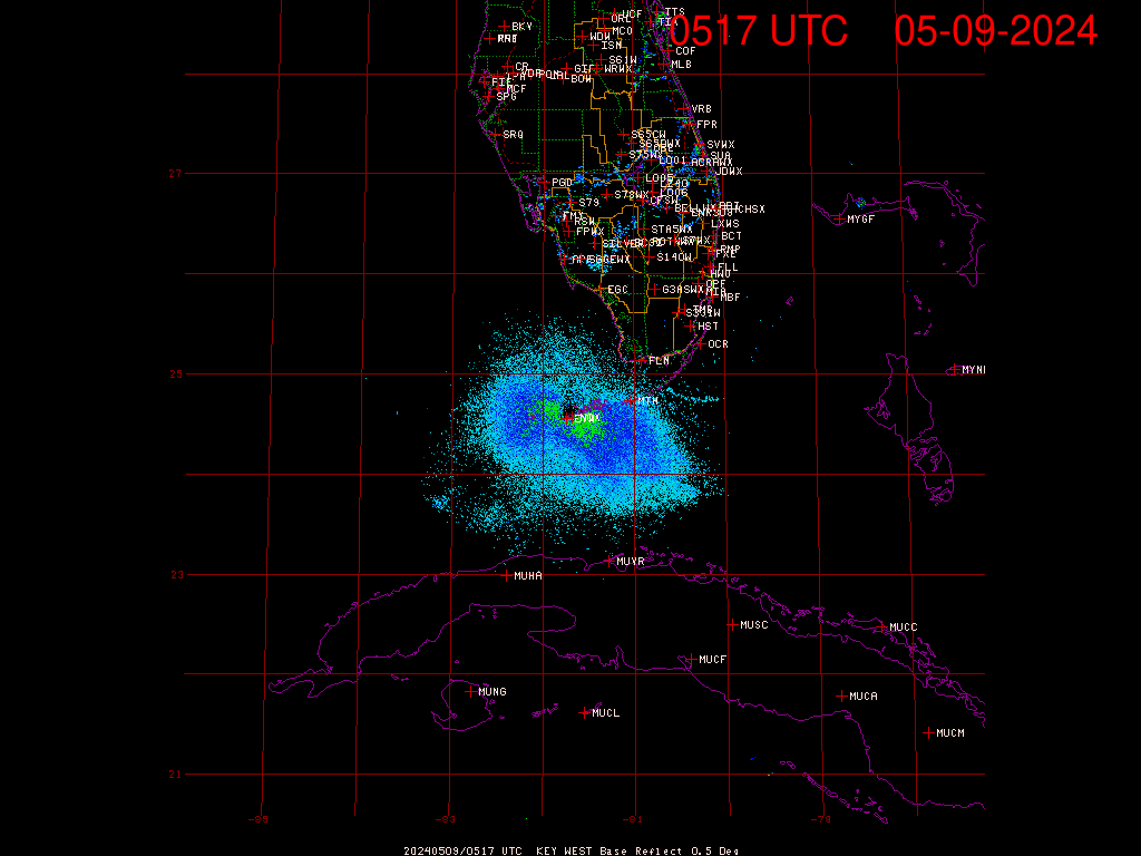
The hurricane eye slowed its movement along the coast of Cuba.
If it stalls now, with half of it over land, it will just fizzle out. It’s already lost a lot of moisture and the cloud tops are cooling. The contiguous central area is only a quarter of what it was before making landfall in Cuba.
I read somewhere it’s just been upgraded to cat 5 again, but that’s just eye-wall max speeds, overall it’s badly weakened.
Levi Cowan just put out an update
https://www.tropicaltidbits.com/
Says that even with Irma still hugging the coast of Cuba that S. Florida is receiving TS force winds up to 60 mph from the outer bands. That is a big factor in assessing the danger from this storm. It is just so huge and so it the hurricane force wind field. If it turns north and goes up the west coast as it is still projected to do, there is no getting away from it’s effects for basically anyone in Florida.
My family has a vacation home in Port Charlotte. The home is almost at the end of a channel that leads into the bay. It has a 15′ sea wall along that channel. But the projected track takes the core of this storm right over it and I’m wondering if we’ll be going down there for vacation for a week during February as we had planned. If things go as the NHC is showing right now that storm will be passing over the Port Charlotte area right around high tide.
Taking the north turn in the last several satellite pics starting at 14:00 Z / UTC / GMT . Goes16 shows the same.
thanks Bill, do you have a link. The stuff I’m following has a few hours lag.
https://weather.msfc.nasa.gov/GOES/
Use the Goes16 ones since they are the highest resolution now. It is getting a lot of traffic of course so you might have to try on and off. Usually only a few minutes behind. Bookmark this page for every day use.
There are also some experimental players for Goes16 which are really good. I don’t if they are going to stick around (whereas the nasa.gov./Goes/ site has been available for almost 15 years now). One has to play around to figure out how to use these sites but they can provide pics and animations for every minute.
http://weather.cod.edu/satrad/exper/
http://rammb.cira.colostate.edu/ramsdis/online/goes-16.asp
thanks for the reply Bill. I found the colostate one but the others will be useful too.
If that is accurate the storm may already have started it’s northern turn.
I don’t know – it just looks like it’s bouncing around the Cuban shore.
If Irma keeps tracking along Cuba’s northern coast a right turn won’t be enough . . . it will have to double back to get to the Florida peninsula. Common sense tells you Irma will end up out in the Gulf. By then Florida will be empty just in time for Irma to start menacing Texas, Louisiana, Mississippi, Alabama and the panhandle of Florida. At that point they can start evacuating all those people into Florida and start filling it back up.
Irma down to 125 mph from interaction with Cuba. Forecast restrengthening though.
http://www.nhc.noaa.gov/
Min pressure: 941 mb , not breaking any records there.
Oh BTW I notice that Dr. Ryan Maue is still listed as a member of the Weatherbell Analytics team at their website.
https://www.weatherbell.com/
Oh BTW I notice that you say things that might intrigue one, and then just give a link to a website.
Ya got something to say or not ?
Guess you missed the claims that Dr. Maue has left Weatherbell Analytics.
All those automobile exhaust emissions from people running away from Irma may be causing localized global warming making Irma stronger. First they had to run north to central Florida, then to the west coast, then back to the east coast, then to Georgia and Alabama, then to Tennessee and Kentucky, and now east to the mid-Atlantic coast. Will they ever catch their breath?
It’s a stampede I tell ya!
The herd may by angry if the ‘monster’ turns out to be nothing more than a clown in a mask!
Coded message to Jose ….
Stop messing around and move up the Eastern seaboard and cut the herd off at the pass. Push the herd north from the mid Atlantic to New York and Vermont. A Canadian clipper will come in from the NW and a nor’easter will catch ’em from the NE. They will be corralled in Vermont! Then let ’em go back home.
Hi-yo, Silver, away!
Looks like this loop of the jet stream, though distant, has been exerting some southerly influence. As this moves out into Atlantic in the next few hours we may start to see Irma move off the Cuban coast.
https://earth.nullschool.net/#current/wind/isobaric/500hPa/orthographic=-81.64,30.72,1039/loc=-68.630,36.678
http://rammb.cira.colostate.edu/ramsdis/online/loop.asp?data_folder=goes-16/mesoscale_01_band_02_sector_05&width=1000&height=1000&number_of_images_to_display=40&loop_speed_ms=80
warmer waters to the N of the storm creating a lot of turbulent convection. Less warm in the Gulf, not so much. Don’t see this picking up its earlier energy.
bear in mind that this whole extent was what was being called Irma and compared to the area of FLA yesterday, not the much smaller, contiguous central area we now see.
The eye was down to 110 mph earlier this morning. It’s still impacted by Cuba but has increased to 125 mph.
Greg and all, here is a good live site…
http://www.newschannel10.com/category/182022/super-doppler-online
Slide over to Cuba. Go to the map key. Select satellite-radar. Adjust opacity to desired level. Select storm track as well.
You can activate the last two hours and also input storm model tracks as well as future motion.
Thanks David A, nice app. Storm attributes plus Tropical options are a nice touch!
As coast turns more to due west, Irma is slowly moving off shore. Not clear whether there is a real change of direction yet.
Cloud tops are warming again
Just found a great vid of Gov Scott addressing the state. Just look at the badly shaven deaf & dumb interpretor to his right ! I don’t know if this guy is for real but he looks like a Monty Python parody.
https://youtu.be/qWAAtwp3bfA
I think it is ‘sign language’. What comes to how people look like, well we’are not all Kardashian’s, luckily.
Pretty petty.
Where were you in the ’80s?
You’ve never heard of the Miami Device?
At least he’s not wearing a T-shirt with his suit jacket. Although close. But it does seem to have a button or two. Maybe a river driver’s shirt. For such a formal occasion.
Looks like an eyewall replacement cycle is underway: