(Edited/updated) From NHC:
…EYE OF CATEGORY 4 HARVEY MAKES LANDFALL BETWEEN PORT ARANSAS AND
PORT O’CONNOR TEXAS…
…CATASTROPHIC FLOODING EXPECTED DUE TO HEAVY RAINFALL AND STORM
SURGE..
DISCUSSION AND 48-HOUR OUTLOOK
——————————
At 1000 PM CDT (0300 UTC), the center of Hurricane Harvey was
located near latitude 28.0 North, longitude 97.0 West. Harvey has
just made landfall on the Texas coast over the northern end of San
Jose Island about 4 miles (6 km) east of Rockport. Harvey is
moving toward the northwest near 7 mph (11 km/h). The hurricane is
expected to slow its forward motion and move slowly over
southeastern Texas during the next couple of days.
Maximum sustained winds are near 130 mph (215 km/h) with higher
gusts. Harvey is a category 4 hurricane on the Saffir-Simpson
Hurricane Wind Scale. Weakening is forecast during the next 48
hours while the center of Harvey is over southeastern Texas.
Hurricane-force winds extend outward up to 40 miles (65 km) from the
center and tropical-storm-force winds extend outward up to 140 miles
(220 km). A Texas Coastal Ocean Observing Network station at
Aransas Pass recently reported sustained winds of 111 mph (178 km/h)
and a wind gust of 131 mph (211 km/h).
The minimum central pressure just reported by an Air Force Reserve
Hurricane Hunter aircraft is 938 mb (27.70 inches).
Harvey made landfall as a Category 4 ending the “major hurricane drought” we have been experiencing in the USA.
#GOES16 captured this geocolor imagery of #Harvey as it nears landfall on the Texas coast. Get the latest info @ https://t.co/cSGOfrM0lG pic.twitter.com/u0O9ChtJeP
— NOAA Satellites (@NOAASatellites) August 26, 2017
#GOES16 captured this geocolor imagery of #Harvey2017 – now a category 3 storm – this afternoon. Latest info @ https://t.co/cSGOfrM0lG pic.twitter.com/hGD22NpNTG
— NOAA Satellites (@NOAASatellites) August 25, 2017
It is now 4324 days since Category 3 Hurricane Wilma made landfall in Florida on October 24th, 2005.
https://twitter.com/RogerPielkeJr/status/900740028665671680

I going to be checking the offshore buoys for the real wind speed. I do not trust the NOAA to tell the truth.
Will not a land recording of Cat 3 strength be required?
The assumption at this stage is that this will happen.
The last time N. Atlantic ACE picked up out of a long slump, it was the beginning of the post-WWII sharp drop in temperatures:
The standard has been for a long time, determined/analyzed as opposed to directly measured when the latter is lower, a determination of highest wind “sustained”/averaged for 60 seconds in the windiest part of the storm, and the official altitude for determining this is 10 meters above the surface.
Harvey had actual Cat-3 surface wind measurement reported by the National Hurricane Center when it was landfalling. I would redirect the question to Harvey having achieved Cat-4 status, because Harvey did so as a result of a 2012 change of the definition of Cat-4 by 1 MPH (and the definition change considered usual practice being rounding to the nearest 5 km/h, MPH and knots). Harvey had a Cat-3 qualifying (barely) actual wind measurement, not merely an analysis that such qualifying wind existed with 10 meters of the surface in the qualifying region of the storm, reported in the #23 Public Advisory on Harvey.
Greg
If storm energy is lower during warming phases and maximal during cooling phases, then this means – we ain’t seen nothing yet!
the airforce says cat 4。
More fake news errrr climate data. Satellites showing 130ishKPH or 85-90mph on the surface. Mosher I thought you guys were all about the surface? You know where we live! NOT 5000ft in the air.
The airforce says cat 4.
sorry im not in the game of distrusting or trusting. just, the air force says cat 4.
The pressure said Cat 4. The Sat imagery and damage assessment may up that in the end, just like Andrew.
Harvey seemed to just finish an ERC and was in pirouette mode just prior to land interaction and in RI mode.
https://mobile.twitter.com/crankywxguy/status/901246608813285376
The Mesovorticies also indicate possible higher ratings.
https://mobile.twitter.com/anthonywx/status/901292304761319424
Stadium effect too.
Those who hunkered down near landfall are in trouble. This will not be pretty, let alone the next several days of continued stalled impact impeading assistance to those in need. .
T’s and P’s to those affected.
History is being made folks, hopefully we learn from it. GOES 16 will help.
@osqsss
Under the old standard that included barometric pressure and storm surge, you are correct that Harvey would be a Category 4. However, barometric pressure and storm surge were removed from the Saffir-Simpson Wind (renamed) Scale in 2009. I have not found a wind speed measurement of 130mph. I’d like to see where that was measured.
OH no. I have been waiting years for the mindless cliche “our thoughts and prayers” to go out of fashion.
” T’s and P’s ” is vomit inducing.
My understanding is that the Air Force hurricane hunters take their measurements in the higher winds at the altitude they are flying at then interpolates what the winds should be down lower and that is how they declared this a CAT IV. The sensors they drop cannot give sustained wind speeds at a given altitude simply because they are descending too quickly.
Has anyone found data from a land based station that shows 1 minute sustained winds of 130 mph (113 kt) or higher that meets the following conditions as per the following NOAA statement: “The maximum sustained surface wind speed (peak 1-minute wind at the standard meteorological observation height of 10 m [33 ft] over unobstructed exposure) associated with the cyclone is the determining factor in the scale.”
http://www.nhc.noaa.gov/pdf/sshws.pdf
During tropical storm Claudette in 1979, Alvin, Texas got 43 inches of rain in 24 hours.
RAH,
My state of the art on the Air Force Hurricane Hunters is 30 years out of date, but in the 80s we dropped sensors through the wall to measure wind speed, temperature, pressure, and dew point all the way to the surface by parachute. The sensor radioed back the readings to the dropsonde operator until impact. That may have changed, but it was a good way to study the vertical components of the eye wall.
Owen in GA says:
August 26, 2017 at 9:25 am
RAH,
My state of the art on the Air Force Hurricane Hunters is 30 years out of date, but in the 80s we dropped sensors through the wall to measure wind speed, temperature, pressure, and dew point all the way to the surface by parachute. The sensor radioed back the readings to the dropsonde operator until impact. That may have changed, but it was a good way to study the vertical components of the eye wall.
———————————————————————————————————————————-
Owen in GA
I was referring to the standards for Saffir-Simpson classification as per NOAA. They say:
“The maximum sustained surface wind speed (peak 1-minute wind at the standard meteorological observation height of 10 m [33 ft] over unobstructed exposure) associated with the cyclone is the determining factor in the scale. ”
http://www.nhc.noaa.gov/pdf/sshws.pdf
So unless the sensors dropped hung 10 meters off the surface for 1 full minute recording the wind speed, they cannot be used for Saffir-Simpson classification. Also, a hurricane of even Cat III strength can easily generate waves higher than 10 meters. Thus any readings from any sensor or anemometer on or over the water surface should be viewed with that in mind.
As a practical matter the difference between a strong Cat III and a weak Cat IV means little or nothing to those in the path. But in science I have noticed that temperatures, sea levels, etc are often written by the highest authorities are expressed right down to 10ths or even 100ths of the unit or measurement. It seems to this layman that precision in applying the standard as stipulated for Saffir-Simpson classification by the NHC, NOAA, Air Force, and all of the press, is sorely lacking in this case. And I will have that impression until someone can show the raw data taken as per the standards stated above that show Harvey had 130 mph winds or higher sustained for one minute ANYWHERE it was measured after, at, or very near the time of land fall.
Phil: As for a 130 MPH actual measurement: The National Hurricane Center’s #23 Forecast Discussion mentions multiple 110-115 knot indications from the stepped frequency microwave radiometer aboard a Hurricane Hunter plane. Although that discussion refers to those as estimates, the SFMR results are effectively indirect measurements of surface wind.
I thought it was temperatures and pressures. It did not seem to make much sense.
I am not finding any buoys that indicate sustained wind speeds above 48 Knots and gusts above 58 Knots.
http://www.ndbc.noaa.gov/obs.shtml
Earth.nullschool likewise shows the fastest wind speeds less than 130 Km/h.
https://earth.nullschool.net/#current/wind/surface/level/orthographic=-93.67,23.97,1723/loc=-95.923,27.631
Perhaps the wind speed suddenly ramped up since the stations last reported. Or… is NOAA reporting speeds near the top of the formation?
Cat 4 … 58 knots …. 130 kilometres per hour …. 125 miles per hour.
What are the winds in furlongs per fortnight?
336,000.05 fpf 😎
NDBC buoys showing 55 to 58 knots. One land station showing 65 knots at 6pm.
Typical NHC hype and media frenzy. Definitely NOT a major hurricane.
I am searching the gulf for a buoy with high ind speed – 9:01 eastern time, I see buoy Station 42020 (LLNR 1330) – CORPUS CHRISTI, TX with wind speed of 35 knots, gusts of 43 knots – it should be hellacious right there at this moment.
Officially, hurricane speeds are supposed to be reckoned at 10 meters – because that is the elevation where flying debris is going to hurt us. Who cares if the wind speed is 100MPH a quarter of a mile up – the wind is always way faster far above the ground!
http://www.ndbc.noaa.gov/station_page.php?station=42020
http://www.ndbc.noaa.gov/station_page.php?station=PTAT2
(Local Time)
Wind Speed Wind Speed (WSPD): 83 kts (95mph)(9:00 PM?)
Continuous Winds
9:00 pm WNW ( 286 deg ) 80 kts (92mph)
Peak gust during the measurement hour
8:50 pm WNW ( 290 deg ) 108 kts (124mph)
8:50 pm WNW ( 292 deg ) 75 kts (86mph)
Phil – thanks. You got the hurricane with sustained winds at 92 MPH.
That establishes the hurricane as Category 1, the lowest level, at 9pm central / local time.
http://www.ndbc.noaa.gov/station_page.php?station=ANPT2
“TIME(CDT)” WDIR “WSPDkts(mph)” “GSTkts(mph)”
09:12:00 PM W 81 (93) 104 (120)
09:06:00 PM W 82 (94) 111 (128)
09:00:00 PM W 93 (107) 113 (130)
08:54:00 PM W 84 (97) 114 (131)
08:48:00 PM W 89 (102) 114 (131)
08:42:00 PM W 96 (110) 112 (129)
08:36:00 PM W 91 (105) 114 (131)
08:30:00 PM W 89 (102) 110 (127)
Approaching Category 3: 96-113 kt
Who cares..
its blown harder before
the wind is good
noaa lies
models suck
ignore the warnings to leave. no one can predict the future.
http://www.ndbc.noaa.gov/radial_search.php?storm=at4
From this webpage for Harvey, there are 993 observations from 08/26/2017 0100 GMT to 08/26/2017 0424 GMT. The highest sustained winds were from Station ANPT2 at 8:42 PM. 96 knots is barely Category 3. The claimed maximum sustained speed of 130 mph or 113 knots is not shown in these 993 observations. Where the 113 knots measurement was taken is not shown here that I can see. If anyone know where this measurement was taken, it would be interesting to know. From all the other measurements on this weppage, the claimed 113 knots don’t seem to be credible.
http://www.ndbc.noaa.gov/station_page.php?station=ANPT2
TIME(CDT) DIR sUST kt(mph) GUST kt(mph)
08:42:00PM W 96 (110) 112 (129)
Mosher: I have always respected you, but you are just trolling. It is not unreasonable to wonder where a particular number comes from. There does not seem to be any credible claim for Harvey to be classified as more than a Category 2. There is only one single measurement at the lowest limit for a Category 3. There is no support for a Category 4 rating based on the 993 measurements referenced.
“Steven Mosher
August 25, 2017 at 8:22 pm
Who cares..
its blown harder before
the wind is good
noaa lies
models suck
ignore the warnings to leave. no one can predict the future.”
They can predict alright. Since 2005 NOAA has predicted no less than 24 major Cat 3/4/5 hurricanes to occur, with their upper prediction bound being 53 major Cat 3/4/5/ storms.
Now they have one finally form and hit the US coast, and Mosh promptly draws a bulls-eye ring around it and declares NOAA the best hurricane sharpshooters around.
Hmm
Phil.
I am Gunna believe you or
https://twitter.com/philklotzbach
In the end the decesion Cat3 or cat4 is actually meaningless. Lets call it cat3.9
still its only wind and water, and we both know those are essential to life and overall
good things.
“000
WTNT44 KNHC 260301
TCDAT4
Hurricane Harvey Discussion Number 23
NWS National Hurricane Center Miami FL AL092017
1000 PM CDT Fri Aug 25 2017
Harvey has continued to slowly strengthen since the last advisory.
Air Force Reserve Hurricane Hunter aircraft data earlier indicated
700-mb flight-level winds near 130 kt, and there have been multiple
estimates from the Stepped Frequency Microwave Radiometer of winds
of 110-115 kt. In addition, there have been winds of 135-150 kt
observed at 2500-3000 ft in the north eyewall by the Corpus Christi
WSR-88D. Based on these, Harvey is making landfall at this time as
a category 4 hurricane with winds near 115 kt.”
Its a conspiracy between the airforce and radar designers!!
Mr. Mosher:
Who cares?
CO2 has been high before.
CO2 is good.
noaa lies.
models suck.
Ignore the warnings to reduce CO2. No one can predict the future.
Gee, it’s like poetry! Iambic pentameter and all!! And we agree 50% of the time.
“In the end the decesion Cat3 or cat4 is actually meaningless.”
Absolutely not…..and it’s the most dangerous irresponsible thing they could do.
Hyping a storm, and then when people see how little actual damage was done…..
…they will think “it’s a cat 4, we should have stayed home”
Because of your agenda…you are blaming models suck….NOAA lies
Well you’re half right….
Surface-based observing sites can’t be used to verify hurricane category. Reason being is that the Saffir-Simpson scale uses a 1-minute average to determine sustained winds, but observing sites use a 2-minute average to report sustained winds.
Mr Mosher,
Interesting Tweet catch. So of the worst storms, Cat4 and Cat5, since 1890 there have been 25 such behemoths with
1893 – 1900….4 – Cat4 storms
1901 – 1914….0 – Cat4-5 storms (14 year span)
1915 – 1919….3 – Cat4 storms
1920 – 1925….0 – Cat4-5 storms (6 year span)
1926 – 1932….3 – Cat4 storms
1935………..1 – Cat5 storm
1936 – 1944….0 – Cat4-5 storms (9 year span)
1945 – 1954….6 – Cat4 storms (CO2 begins to have an effect per theory)(1893 – 1954 17 Cat4-5 storms)
1955 – 1958….0 – Cat4-5 storms
1959 – 1961….3 – Cat4 storms
1961 – 1968….0 – Cat4-5 storms (8 year span)
1969……….1 – Cat5 storm (34 years since last 5)(CO2 effect increases further)
1970 – 1988….0 Cat4-5 storms (19 year span)(CO2 effect increases further)
1989……….1 – Cat4 storm
1992……….1 – Cat5 storm (CO2 effect increases further)
1993 – 2003….0 Cat4-5 storms (11 year span)(CO2 effect increases further)
2004……….1 – Cat4 storm
2005 – 2016….0 Caft4-5 storms (Great USA hurricane drought period)
2017……….1 – Cat4 storm (1955 – 2017 8 storms since the time CO2 has had an effect on climate)
Thanks for the informative Tweet from Mr Klotzbach
As I’ve said before the buoys were not supporting Matthew as a cat 3 next to FL.
Here’s the problem. Once you’ve been caught (several times) adjusting data without justification (but with an apparent agenda) it causes anyone serious to start second guessing any data collected.
Still this is an ugly storm. A 20ft storm surge would not surprise me.
I trust the Willis approach of letting the data guide the conclusions rather than the other way around.
Regarding Philip Klotzbach’s tweet that Katrina had wind speed less than Cat-4 at landfall: At 8 AM CDT Mon Aug 29 2005, Public Advisory 26b gave a position of 29.7 N 89.6 W which Google Maps shows as having made landfall, and the reported maximum sustained wind determination was 135 MPH.
Trust the Buoys?
why?
Unadjusted data.
Mosh will tell you that even if you remove the unadjusted bouy wind speed data it has no effect on global temperature calculations, therefore the bouys can safely be ignored in favor of models.
Good Lord!
Steven Mosher: !!**where else do they get data? **!!
There is a VAST ARRAY of weather instruments ALL OVER THE COAST!!!!!!!!
for God’s sake, man, Pull UP!!
Mosh, you are an emotional basket case full of straw man bleating.
However at least there were pretty pictures in your long post. Alas, exactly ZERO new information and nothing cogent to finding a ground based wind speed reading confirming Cat 4 ground winds.
When you find that, let us know.
Is it not clear to you that say wind speed ratings like for Carla in the 60s were less likely to capture the highest wind, and comparisons should be made via the same methodology?
Try to make a cogent response. I have seen you do this on occasion.
Mr Mosher,
Please do try to stay relevant and stop cluttering up the board with wild conspiracies
I hope everybody stays safe in Texas and Louisiana!
The Alarmists will cry Global Warming as usual.
Because 2016 was the “hottest year ever” (by .05 degrees or something equally phenomenal) and now it proves warming causes a Cat 4 hurricane every 12 years or so, compared to whatever number in the past makes this look scary. I think I understand now.
I thought 0bummer was supposed to have put a stop to it all?
He did. This will be Trump’s fault.
LOL – Bingo.
Gosh, you’re right. Just think; there were no US landfall hurricanes during the 8 years Baroque Obama was in office. And now, less than 8 months after Trump was sworn in we get our first landfall hurricane!
I think I better put a sarc/ tag here just in case someone from CNN reads my comment; takes it seriously; promotes the idea; and a new round of PR firm hired $25/hr protesters take to the streets against Trump … and I get blamed for it.
The Bush years were hurricane free, so Obama had nothing to do with it. It was Bush’s doing.
Bush’s second term.
Let the wind blow high
Let the wind blow low
Through the streets
In my kilt, I’ll go
All the lassies say hello
Donald, where’s your troosers?
You are correct. Someone will say that because Trump withdrew the US from the Paris Accords that he caused the hurricane. Just wait for it.
“In 1886, Texas was hit by four hurricanes, including two major hurricanes”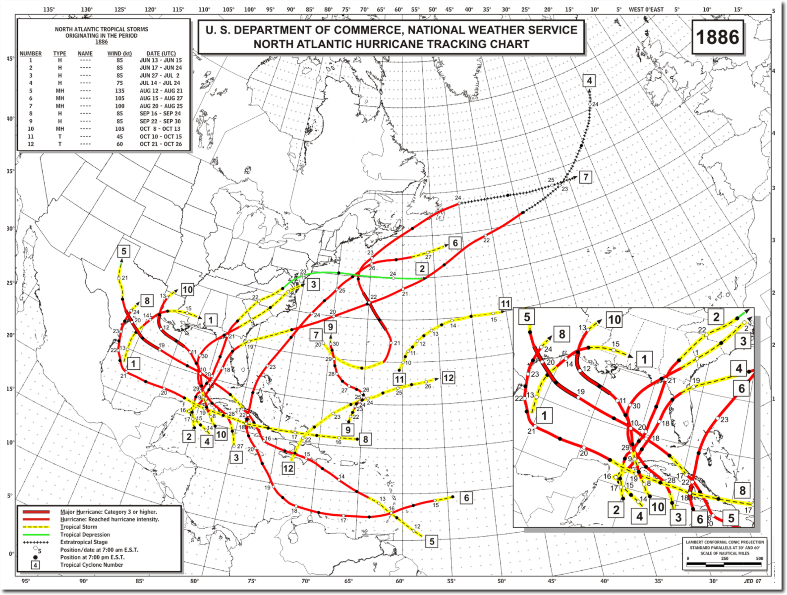
https://realclimatescience.com/2017/08/first-texas-hurricane-for-nine-years/
“In 1886, Texas was hit by four hurricanes, including two major hurricanes”
https://realclimatescience.com/2017/08/first-texas-hurricane-for-nine-years/
Finally! Global Warming is now proven beyond any doubt. Whew, that was a close one!
DAMN!
They finally got 1% of their projections right.
We’ll never here the end of it.
PS Prayers for those in Harvey’s path.
actually no….a couple of days ago they were predicting it would fizzle out
Joe Bastardi has been correct so far.
Technically, they may have had reason to predict in the direction of “fizzling out” since for 12 years hurricanes did change course or fizzle out. It’s what one would tend to predict when a straight trend line is used. The past cannot predict the future, but people just don’t get that.
Sheri…their reason was because their most trusted models said it would
Actually a couple of days ago it had ‘fizzled out’ and they were predicting that it would it would redevelop:
“Ex-Harvey Poised to Threaten Texas
Dr. Jeff Masters · August 22, 2017, 1:56 PM
Above: The remains of Harvey as seen by the GOES-16 satellite at 9:15 am EDT Tuesday, August 22, 2017. Image credit: NOAA/CIRA/RAMMB. NOAA’s GOES-16 satellite has not been declared operational and its data are preliminary and undergoing testing.
All eyes are on the hurricane-friendly waters of the Gulf of Mexico’s Bay of Campeche, where the remains of Tropical Storm Harvey are expected to organize into a tropical storm or hurricane that will threaten Texas and Mexico late this week.”
Phil, don’t quote Masters….when you know I wasn’t
” Who are “they”? Can you show us these predictions? Dr Masters says “all eyes” were on the hurricane friendly waters. That suggests a common expectation that it would re-establish, but it would be good to see the predictions of fizzling out so we can see for ourselves.
I just visited the Weather Underground website, and they are calling Harvey a CAT 6, most dangerous since 47 years ago. Wasn’t that before Global Warming? Masters is really trying to scare people.
Cat 6? 1000baseT?
yeah, wind speed 10x faster than CAT5.
No harm in exaggerating at bit : WOLF , WOLF , WOLF !!!!
By that measure, about the only place in the solar system where one would find a legitimate CAT6 is called Neptune.
Dr. Ed,
Point well taken.
What Warmunistas fail to recognize is that the colder a planet, the higher its wind speeds.
Neptune? How about Jupiter?
Yet Intellicast shows wind speeds around 80 MPH. So does the latest image in the Earth.Nullschool satellite model.
Link please? I visit Weather Underground quite often and nowhere do I see a reference to “CAT 6.”
Cat 6 is the name of a Weather Underground blog, chosen as a name 1 step above the top end of the Saffir-Simpson hurricane scale.
So they were NOT calling Harvey a CAT 6, as stated above. Let’s be careful with our information, folks.
The MSM have been getting ready for this – how to report it without mentioning the hurricane drought. So the narrative is: Very few landfall hurricanes are cat 3+ (implication – this is a big one thanks to AGW); This is the strongest in 12 years (implication – AGW is making hurricanes stronger); etc, etc. They have no shame.
Hey, they’ve had ten years to write the article, they have got the wording perfect now, just leaving a dotted line for the name.
sst in the area is warmer than normal.
Is it?
Gulf of Mexico looks normal to cool to me:
http://www.maineharbors.com/weather/seatemp4.htm
Especially off the south Texas coast.
Here’s the anomaly image from Nullschool, slightly above normal along the TX coast and slightly below west of the Yucatan.
https://earth.nullschool.net/#current/ocean/surface/currents/overlay=sea_surface_temp_anomaly/orthographic=-99.94,21.03,522
Pop,
Thanks. So at the moment it does appear to be above slightly warmer than “normal” water.
Too funny gloatus. lloks like your eyeballing is not the BEST way to do things.
funny that you trust nullschool.
1.3C Warmer than it is normally at this time of the year.
Ideally WE wont subsizing the the rebuilding of the area..
Folk have been warned.
1. The area is prone to flood risk
2. The best science says that risk will INCREASE not decrease in the future.
3. Folks who choose to live in risky areas should do so at their own peril and not depend on bailouts
simply because they choose to doubt the science.
But far below normal in most of the arctic? I guess we aren’t going to go ice free like you said could happen in 2012, yet again.
Huh?
Ice free in 2012?
I read Ar5.. more like 2040-2060
Yeah, mosh, just like all those dopey people who live in san fran should do so at their own peril and not expect bailouts when the next big one hits…
Misuse of “normal” again! Normal means conforming to an established norm, such as 98.6F for human body temperature while alive, or 20/20 vision. Such norms are established by long-term observations and are specific figures, not averages. For humans, deviations of two or three degrees above or below 98.6 are cause for concern; deviations of ten degrees are cause of death.
Sea surface temperature has no norm. It has a history, known or not; it has mean or average temperature for a specific time period and location; it has fluctuations from minute to minute, hour to hour, day to night, season to season, year to year, etc. No norm. Perhaps SST is slightly above some long-term average for the site and the date; perhaps not; perhaps there is a cause/effect relation between above-average SST and wind speed; perhaps not. Surely there are other areas in the world’s oceans that are currently showing fluctuations above the long-term average for the site and the date. Why are no Cat-4 hurricanes occurring at all those places?
and never mind, mosh, that your dopey agw theory has demonstrated weaker u.s. storms for twelve years now. (too funny)…
Sea water is warmed by radiation and cooled by convection. Convection gives energy to storms. A cooling planet would therefore have stronger storms.
http://www.ospo.noaa.gov/data/sst/anomaly/2017/anoma.8.24.2017.gif
Define “normal”.
Steven Mosher- if you’re trying to make a point, it would be nice if you’d state it directly instead of your snarky little comments.
Are you trying to blame Harvey on human activity? There is NO measurable connection between hurricanes and human activity. To imply that Hurricane Harvey is “our fault” is no better than Pat Robertson saying it’s “God’s punishment.” Even worse is to tell people we know how to prevent or control hurricanes. Absolutely false. That’s beyond misleading- it’s FRAUD.
We need to throw all of the confederate statuary into the volcano to appease the hurricane gods. Pronto!
“2. The best science says that risk will INCREASE not decrease in the future.”
You guys keep saying that but there is no “increase’. Where’s the increase?
http://www.ospo.noaa.gov/data/sst/contour/gulfmex.c.gif
@ Mike Jonas
Here you go, from the BBC:
“Greg Abbott has asked for more federal aid to cope with the storm, which may be the worst to hit the US in 12 years.”
Almost perfect prediction but you forgot the “may” which implies they’re searching through the last 12 years of almost-as-bad hurricanes to see if this one just about tops them all.
“be the worst to hit the US in 12 years”
I heard the exact phrase in German television yesterday. Pure propaganda since they didn’t say “be worse than the previous one 12 years ago.”
The Weather Channel has stated on TV earlier today, that the LAST Category 3+ Hurricane making landfall was Wilma back in 2005. They say the Category 3+ Drought might end today.
TWELVE YEARS ago!
Mike, they must have plenty of shame (seeing how they never use any of it… ☺)
So far, ABC (USA’s) has been saying there has not been a major hurricane hit the USA in over a decade. Not a specific number, granted, but considerably more honest than I would have expected.
4324 days
Don’t expect to hear that bit of trivia in news. Gotta maintain the narritive.
Does this mean Al Gore can restart his apocalypse clock … & we can all be scared again ??
I do miss that,
these days when I want to be scared I have to look in the mirror.
One thunderstorm does not end a drought…
…and one hurricane does not either
“The 1886 Indianola Hurricane destroyed the town of Indianola, Texas and as such had a significant impact on the history and economic development of Texas.[1] It was the fifth hurricane of the 1886 Atlantic hurricane season and one of the most intense hurricanes ever to hit the United States”
and it was a cat 4.
…and measured how?
MSM/ABC in Australia is already marketing this as the largest hurricane to ever hit Texas and will leave huge areas of Texas uninhabitable. Soon it will be touted as the biggest in recorded history and category 6 at least. It is all exactly as they predicted and it is all Trump’s fault for leaving the Paris agreement. Send money now…… Ho Hum.
I hope you’re kidding. I fear you’re not.
I’m just waiting for the MSM to label the affected Texans as “Climate Refugees” it’s certain to happen
11pm news(ABC australia) they stated it was 4 when it hit land but in an amazingly short time? its now a 1 and a tropical storm
I was afraid my grandkids wouldn’t know what a hurricane is. Thought maybe CAGCC might have been real and ended strong hurricane landfalls in the US forever. Looks like at least this weather phenomena is back to normal. Hope all those in Harvey’s path make it through OK.
It is obvious that while Harvey is right on the edge of Cat/Cat 3 that the media will push it over into Cat 3 regardless of the data. The double eyewall condition is not stable and contact with land may just collapse the structure. Still a lot of rain and flooding and dangerous but watch the MSM for impact inflation.
Personally I am looking forward to the YouTube channel of Texas storm fails. Aka “Deep? Hah. Hold my beer and watch this.”
Dawg: by the accepted definitions of hurricane categories (10-meter altitude sustained wind, as in Wikipedia and other obvious places), data show Harvey to barely be Cat2, if you squint and look at it sideways.
Observing sites report sustained winds using a 2-minute average. For some reason the hurricane folks use a 1-minute average for sustained wind. Thus, it’s not entirely accurate to determine hurricane category from surface observations, the latter will always come in lower by definition.
Hurricane Cat-5 Bill Nye is spinning up to sue Disney and a “gravy train” of others for “non-payments of profits et al.”!
Maybe he has second thoughts about the $3 Million he sunk into the new “Solar” start-up “company” (no business no product no shit) in San Jose.
Ha ha
He should have gone to the beach far enough north of Rockport to be in the eyewall on the windward side to report on how terrible it was and how it was mans fault.
OMG. That means it’s increasing rapidly! 🙂
Global warming catastrophic prediction hiatus over I guess?
My prediction for the next five years: cooler temps, more Arctic sea ice , more N Atl ACE.
But how will that affect the fishing???
Jones, those never go into hiatus, just just move the thimble around to pick on whatever the latest in bad weather is when making their (failed) catastrophic predictions
God has a sense of humor. Al Gore raised the spectre of Hurricane Armegeddon, and God followed up with a decade of Hurricane Drought. Classic.
The nice thing about a “drought” is that then next will constitute a “massive increase”.
moste likely something has to “compensate to make the “average”
Actually the average for Atlantic hurricane numbers and intensity since 2005 has been running pretty much right along the historical record mean. It’s the lack of them hitting the lower 48 that has been quite unusual.
If the Hurricane Hunter planes say is now Cat 3, probably is. If it stalls like Joe Bastardi at WeatherBell and increasingly the NHC says, is NOT good. This could become another Katrina flooding disaster. Spun many ways. But no matter how spun, still a genuine disaster. Lets hope the vulnerable have evacuated.
many will stay. who believes in models.
nasa lies about windspeed. flood? water is essential to life.
Yes many, like DeGrasse Tyson, cannot tell the difference between the science of 24h weather forecasts and politics of 100 y climate models.
Certainly appreciate your astute pre-emptive attempt to blame any deaths due to this storm on climate sceptics though.
Of course, with Katrina, many stayed because they told to evacuate too many times for storms that fizzled. So it cuts both ways.
Were told
…hitting an all new low
look at all the benefits of water!!
SM, do not appreciate your sarcasm. I was stating a simple hurricane hunter fact, not generally accepted by many skeptics here–perhaps for good reason.
What you did not know is that my father, buried at Arlington with the second (peacetime) neck order and a 21 gun salute, was commander of the 409th typhoon chasers back in 1948-1950. His contributions (including an Air Force patent in his name) and personal observations from command piloting converted B-29s into Pacific typhoons with early drop sondes are the stuff upon which NHC is built today, I absorbed it all at the dinner table. You got nothing except bile.
Mosh hasn’t even been keeping up with this…he’s just mouthing off
…those same models they relied on a few days ago to predict it would fizzle out….those models
ristvan August 25, 2017 at 5:12 pm
Mosh’s problem is that he is only playing a scientist on media. BEST lists him as a scientist, but since he doesn’t practice the scientific method, he isn’t one.
He’s an English undergrad with a brief “career” in marketing, which in CACAland makes one a scientist, if you have embraced the consensus and joined the Borg.
SM only has sarcasm it seems.
With Katrina I waited until Sunday AM to leave due to having
evacuated so many times when the hurricane changed its path
and not much happened in the city. I was supposed to start
teaching at my university the next day and two of my kids were
having the first day of class for their senior and freshman years
in high school and were vehement about not leaving for a false
alarm.
Since Katrina hit on the other side of Florida, it seemed natural to
think it would slow down and dissipate once it hit land or at least
be less powerful. Instead, it crossed Florida into the Gulf and at
least the way I remember it, went from a Cat. 1 to a Cat. 5 overnight
and was projected to land near N.O. 24 hours later. So, that was a
big reason people waited – it hit on the Atlantic side of Florida first.
Later, they realized it had crossed a super-heated patch of water
that allowed it to intensify so rapidly.
It’s certainly NOT the people’s fault for rebuilding in an area that has been decimated so many times before by storms of this magnitude, or rebuilding to the same standards that allowed similar damages as prior storms.
My suggestion would be to either allow nature to keep the islands as a buffer zone and/or rebuild the areas to withstand these storms.
Those that have not got out of the way will “evacuate” when it hits.
At the moment the moon is in half moon phase, so neap tides. That will help a bit.
If it stalls…
I hate to say it…but it looks that way
A century ago my family vacationed in Rockport, my wife graduated from highschool there, and we currently live and evacuated from there in the late morning of the day it struck. I have been in and run from several hurricanes since 1960, including Celia (1970). Recently I went to a talk at the Rockport Historical Society about the damage Celia did to the Jackson Seafood Company. This time it will be to the sports fishing industry and all those trailers we knew were temporary. We were going to stay in a probable secure place, apparently still so, with daughter and son-in-law but made the decision with others to leave for Austin where I write this high above the hill overlooking the city with quite a wind outside. Part of the reason for leaving was the information provided by the brave hurricane intruding fliers.
Will let you know in a week or so how it should be classified, to the nearest decimal.
NHC update at 1800 CDT reports Harvey is up to Cat 4.
Which brings a genuine question from me.
Per Update 22: “flight-level winds of 129 kt and SFMR winds to 102 kt. Based on these data, Harvey’s maximum surface winds are estimated to be 110 kt”
So, is the things category based off of any measured winds no matter what elevation?
I keep asking that. Pre satellite recordings were wind speeds recorded on the ground, and or in flights, and if in flights at what elevation.
There are three issues concerning wind uncertainty. 1. The SS scsle is defined by sustained 1 minute winds. What about gusts? 2. Altitude. Hurricane hunters must remsin far above the turbulent deck ( whether 2.5 or 10 meters), so project slower winds down toward surface based on friction. Inherent observational uncertainty. 3. Storm organization can rapidly change, for example eith eye wall replacement. So this hour is not ewual to next hour.
I see ‘cat 3’ less a precise measurement and more a meteorologist informed judgement. No hyped conspiracy, just a tough call. And, like with tornados, verifiable after the fact from wind damage. Hence my conclusion that 2916 Hermine was a TS and not a Cat 1.
No, hurricane winds are 1 minute sustained surface winds, measured with anemometers. Anemometer height of 10 meters above site elevation is by the book, but most stations don’t follow the book.
I do know that they use a generalized wind profile to convert flight level winds to surface winds, but I don’t know what the criteria is for calling it a specific category. Any observed winds or just surface winds.
http://www.nhc.noaa.gov/aboutwindprofile.shtml
Lurking: no. The wind speed has to be sustained for a minute, and has to be at 10 meters.
A quarter mile up is irrelevant. The wind is always fast way above us. But, up there, there is no aluminum siding to fly through your windows. So, 10 meters it is; yes, about two stories up, where things are relevant to us on planet earth.
Ok, so I assume 50s and 60s recorded sustained wind records were land based 10 m readings.
If this is so the same criterion should be followed. Measuring via guestimating from flight elevation appears problamatic, as every surface produces disparate friction.
So the combination of land based readings, which may not catch the maximum, and visible damage post the hurricane may give you s ballpark on wind speed.
It would appear likely that earlier storms had a greater chance of missing peak winds.
https://earth.nullschool.net/#current/wind/surface/level/overlay=temp/orthographic=-58.43,26.36,777/loc=-96.867,27.867
54mph is the highest surface wind i could get the cursor to find right now
thats nasty but bearable?
the rains the big trouble id guess.
Just noting that the new Goes16 satellite has been “operational” for the past month.
Much higher resolution. Eyewall is bigger now (signalling some weakening) but it is more defined. Outer-banks landfall in a few minutes. Moved a little east now, so Corpus Christi misses the more damaging east-side winds.
https://weather.msfc.nasa.gov/goes/abi/goesEastfullDiskband02.html
Let’s see how all those wind farms in South Texas handle this…
I thought the highest concentration of them was in the panhandle in the north.
Plenty around Sinton TX, just a few miles west of landfall.
Joe Bastardi at Weatherbell called Harvey a Cat 3 this afternoon and said that it will weaken and loop back out to sea, travel up the coast and then hit Northeast on the Texas coast later this week, after strengthening into a Cat 3 again.
Unreal … over 11 years with no landfall of a major.
They also estimate wind speed by pressure. Certain wind speeds are associated with certain pressures. Also, just looking at the latest satellite pics with a most impressive eye formed, the wind is strong with this one.
Now that the eye is on land, I am not seeing any surface sustained windspeeds higher than 80 MPH. Please chime in if you see one reported. Not from an airplane, and not a pressure proxy. Measured, sustained windspeed at 10metres elevation is what I want to see.
Yes, I agree.
I have a feeling that flooding will be the worst aspect here, not windspeed.Harvey is big and carrying a lot of water inland
Fulton Beach TX Wind 58, gusts to 74, top speed of 97 predicted (all in MPH).
So thus far Cat 1 on ground based readings.
Yes, the slow looping storm with long duration rain will be the problem.
Why problem? Although severe flooding is to be expected in the short term, Texas had an almost 15-year period of severe drought, meaning that the long-term effects of major rains would be beneficial to the water reserves of the state. Each medal has two sides, hurricanes are, at least for nature, also long-term for humans helpfull.
Who said Texas would have a permanent drought?
Many implied it, Hayhoe was one of them.
Note how it is not said, but implied.
So thus far Cat 1 on ground based readings.
Yes, the slow looping storm with long duration rain will be the problem.
NOAA calling a cat 4 landfall.
latest paths look like a wobble and then static SW of Austin.
Wet, wet, wet….
Here’s the problem. If NOAA is calling this a Cat-4 and it’s not on the ground and people are hanging around and doing selfies. What happens when a “real” Cat-4 comes ashore? This is where their alarmism will kick them in a$$.
NOAA wants it to be a CAT4 since they totally committed the the AGW BS.
They need to be challenged.
Fortunately, thanks to Al Gore’s internet, observers around the world can see the deceit.
Time for a congressional over site committee to look into this scam.
Joe Bastardi needs to help us.
EW3: Congressional oversight hearings accomplish nothing but a way for Congress to avoid doing actual work.
I am calling NOAA out on the Category 4 rating. There does not seem to be but one observation out of more than 900 to support a Category 3 rating. If this one single observation from Station ANPT2 at 8:42 PM at the bare minimum for the rating (96 knots) is disregarded, only a Category 2 rating would be justified for Hurricane Harvey. Observations are at http://www.ndbc.noaa.gov/radial_search.php?storm=at4. Where is the justification for a Category 4 rating? I am not pretending to minimize the danger or harm that a Hurricane like Harvey can/will cause to human beings and/or property. Otherwise, the Category ratings become meaningless.
You are right.
Do some key screen grabs.
000
WTNT44 KNHC 260301
TCDAT4
Hurricane Harvey Discussion Number 23
NWS National Hurricane Center Miami FL AL092017
1000 PM CDT Fri Aug 25 2017
Harvey has continued to slowly strengthen since the last advisory.
Air Force Reserve Hurricane Hunter aircraft data earlier indicated
700-mb flight-level winds near 130 kt, and there have been multiple
estimates from the Stepped Frequency Microwave Radiometer of winds
of 110-115 kt. In addition, there have been winds of 135-150 kt
observed at 2500-3000 ft in the north eyewall by the Corpus Christi
WSR-88D. Based on these, Harvey is making landfall at this time as
a category 4 hurricane with winds near 115 kt.
In the end they may revise and call it a Cat3 based on 10 meter measurements
but the forecaster Beven called it a Cat4 based on 3 separate data sources (all above 10meters)
Wait till the dust settles and the flood waters drain.
without judgement. There is no need to go off half cocked.
Look at all the data. take your time.
From a warning standpoint?? ya I’d call it a CAT 4.
Mosher says…
From a warning standpoint?? ya I’d call it a CAT 4.”
—””’
What? What kind of test is that. So far it is a strong CAT 2 with one barely CAT 3 reading.
From a warning standpoint?? ya I’d call it a CAT 4….
..and then when people see how little actual damage was done….then what?….call it a cat 6 next time?
In a narrow area, it was cat 2. Otherwise, Cat1.
Comparisons to Carla seem to have disappeared once all of this became evident.
Extreme weather events like this one are part of the current climate so stopping climate change will not stop extreme weather events from happening. There is no know climate to change to that will put an end to extreme weather events. Maybe if we could just get rid of all of Earth’s atmosphere, high wind evernt would never happen but droughts would go on for ever and life on Earth would no longer exist.
This is video on the ground in the eyewall as it went through Rockport, TX, one of the hardest hit areas. A lot of damage. https://www.facebook.com/wxchasing/videos/vb.290340114630959/521430981521870/?type=2&theater
BUT NOAA IS LYING… Phil says so
BUT NOAA IS TELLING THE TRUTH…Steven says so.
Steven ==> Why do you lower yourself to arguing with children (and childlike minds) who troll here and say childish things? It is embarrassing to see a grown man squabbling with nasty-mouthed kids…..
…it’s even more embarrassing to see that grown man trolling like this
Phil said he cannot find ANY ground based readings above a very weak Cat 3.
Can you?
Mosher reaches CAT 4 troll.
No Sheri.
I merely report what data they made the call on.
They dont lie when they report the actual three systems, one of them air force.
You all expect real time perfection.. and then whine and esk for edit functions for your comments.
funny.
forecaster did his job. If they want to revise they will.
Kip
why do you remain silent when you see the slugs here attack forecasters who are scrambling in real time doing the best they can?
have you no honor?
I note that the Rockport weather station anemometer appears to have failed at 9pm CDT, just ahead of landfall:
http://www.ndbc.noaa.gov/station_page.php?station=rcpt2
Top recorded gust was 94kts.
Gavin S. has said that climate is average weather.
In all technical seriousness, assuming that hurricanes arive every 5-10 years, how long does the sampling period need to be for the average to converge to its “steady state” level?
Failure to adopt a proper averaging period and failure to keep track of the complete distributions of variable data leads to inappropriate attribution of causes. One such might be looking at Houston rainfall data to conclude that “recent extremes are greater”. This is particularly ironic if even more extreme events had destroyed their recording stations.
A lot of damage…I hate to have to point this out….but that’s not a lot of damage
Look at the news today. There is significant damage. Homes and businesses demolished.
Now, go to youtube, and enter “q00 mph” – and see actual 100 mph winds.
‘100mph’ not ‘q00 mph’
If rainfall tallies are anything like what is being predicted – as much as 35 inches in some places, then the cries of “climate change” and “extreme weather” will reach epic proportions. Of course, drought, as in the 2011 drought, are also “climate change”. Funny that.
It will be interesting if the rainfall is unprecedented.
Steven M, it will not be.
During tropical storm Claudette in 1979, Alvin, Texas got 43 inches of rain in 24 hours.
“As the water rose, the National Weather Service issued another ominous forecast: Before the storm that arrived Friday as a Category 4 hurricane is gone, some parts of Houston and its suburbs could get as much as 50 inches (1.3 meters) of rain. That would be the highest amount ever recorded in Texas.”
the cries of “climate change” and “extreme weather” will reach epic proportions even if it does not rain. They have already been written, just leaving a blank to fill in the name of the storm.
“Hurricane Harvey downgraded to category 3 storm as winds weaken, makes 2nd landfall:”
http://abcnews.go.com/US/hurricane-harvey-makes-landfall-texas-category-storm/story?id=49412285
WOW….so they changed the definition of a Category 4 storm and will now say that we’re getting “more severe storms” due to climate change. Oh, that’s man-made climate change for sure.
KTRK-TV (local station) says at the moment the eye is moving NW at 8 mph, winds are 60-80 mph nearby (not necessarily what is used in official measurements).
At 3am central time. Beeville Texas should be in the worst of it all.
They report wind at 43 mph, gusts to 47 mph.
Stick a fork in it. Earlier this evening, the weather guys were saying this was going to take a tour of th eGulf Coast with wind speeds of 75MPH and higher. Nope, not gonna happen.
https://www.wunderground.com/personal-weather-station/dashboard?ID=KTXBEEVI3#history
ABC news just now:
Copano bay is a beautiful remote area, very lowlying and lightly populated. Refugio is the largest town, off the bay on a relatively high area. All the houses on the bay are built for heavy weather. I may be passing through their on the way to Corpus Christi this coming weekend.
If I do, I will be certain to report what I see.
Refugio , reassuring name !
A lovely small town built where it is due to the wisdom of the Spanish in noting where the Indians stayed for safety during heavy weather. Fishing and hunting in the area is marvellous.
In a separate note there is a large windmill installation on the northeast shore of Corpus Christi bay. They are huge and hideous, visible from across the large bay. I can only wonder how they have fared through this storm….
I’m waiting for Gore to now claim that the number of hurricanes has increased 10,000% with the arrival of Harvey. Gore’s camera crew is now deployed to film footage for his next epic – “Inconvenient Death Storms”
I thought fat slobs were supposed to die young. So why is Gore still waddling around?
Read somewhere now down to Cat2, losing power rapidly. No figures for storm swell, so I just it is not a major problem.
Weather channel
NHC:
WATCHES AND WARNINGS
——————–
CHANGES WITH THIS ADVISORY:
The Hurricane Warning and Storm Surge Warning have been
discontinued south of Baffin Bay. The Hurricane Warning north of
Port O’Connor to Sargent has been changed to a Tropical Storm
Warning.
now reports of Cat1. It’s blown itself out.
No figures for tides and storm surge, With half moon we are at neap tide part of cycle, so no extreme tides.
Flooding seems to be the remaining risk.
So 1886 takes the record for worst storms for Texas.
That was a period of cooling too. See graph in initial comments.
Steven Mosher August 25, 2017 at 8:30 pm
You forgot the cry of adaption not mitigation
If you live in an area prone to environmental danger adapt or move on. The Somerset levels have the same problem in UK the population will pay £200m to save 600 properties from flooding. Why am I paying to protect people who needed to consider the risks when they purchased properties.
Yes I believe in adaptation before mitigation.
we dont prepare for the weather of the past
Hurricane, tornadoes and flooding rain, it is a terrible event regardless of the final wind speed. If you want to help those affected:
https://give.salvationarmyusa.org/site/Donation2;jsessionid=00000000.app30108b?df_id=27651&mfc_pref=T&27651.donation=form1&NONCE_TOKEN=3A53A5C38DFA352E5611D258EAEBAC18
God protect the survivors and God bless America.
Most tropical weather is not tgat bad.
All of it is natural.
The vast majority of people are merely inconvenienced by storms.
It is long past time to back off the overwrought emotional responses.
Storms have and will be with us always.
The focus needs to be on those relative few impacted seriously.
The exception proves the rule. The end of the “hurricane” drought emphasises the length of that drought.
So, one storm ends a drought?
It will be fun if this one flyer/exception does not change the extrapolation into the future.
Weather prognosticators have no doxastic comittment or Skin In the Game (the title of N. N. Taleb’s next popular book).
Aw, come on Doug. You know how this works.
11 years and 10 months without a major striking the shores of the lower 48 was just luck! But a major striking anywhere in the lower 48 is confirmation of AGW/Climate change.
During the so called “Hurricane drought” the “scientists” decided that the “relationship” between Tropical Cyclone intensity and AGW/Climate change was very “complex”. But as soon as a couple more majors strike US shores that “relationship” will no doubt become simpler, like it was before, immediately after Katrina.
I lived across the ICW from where H. Hugo’s eye came ashore. Lots of hysteria, little consequence, even of H. Hugo there.
Hugo was pretty bad north of its track. Pine forests flattened with tree trunks snapped like match sticks. The National Guard wouldn’t let me drive all that far south of Myrtle Beach, so I walked and saw beachfront houses that had been up on twelve foot poles smashed two or three blocks inland, when I got down towards Surfside and Murrells Inlet. I sure was impressed.
Current radar indicates it has moved pretty far inland and has not yet stalled.
With the eye so far inland it must be weakening quite a bit.
My friends in Corpus Christi had windsvwell under 100 mph.
We in Houston are having strong but not flooding rains so far.
Streets in my flood prone area are still open and safely passable.
The winds are definitely tropical storm level, blustering, wet and extremely humid.
Our power went out for a few hours when a local transformer blew. Our wonderful neighbors let us tap into their generator and we kept the refrigerator going, but the power was back on in a few hours.
The storm bands, now that the eye is inland, are coming at such an angle that the rains tend to train long ways across our area, dumping rain with fewer breaks. This increases flood risks for Houston metro area.
So if the storm does stall in its current position we may see some of the flooding start.
Headed for the San Antonio Austin area it looks like now. I was in training at Ft. Sam Houston in San Antonio when Hurricane Allen came ashore near Brownsville in 1980 and came up our way as it dissipated. Some genius opened the fire escape door at the end of our barracks bay which was about 4 stories above the ground to get a better look. It took three of us pulling on the bar with all our strength to get that damned door closed.
None of our friends evacuated….they are all fine….gens up and running, they are making breakfast
Said there’s some trash and limbs down….
Still being reported as a CAT 4 hurricane with sustained winds of 215 kph, gusts to 270. No disrespect to those at the centre of this but the Aussie MSM are blowing this out of proportion.
Hyping far distant storms….or ignoring them….is a time honored double.
The story of Noah is perhaps the most ancient example of this….
BBC too.
Despite ‘No fatalities (sic – Zero is singular) confirmed’. Thank goodness
I think they mean that, so far, no fatality has been confirmed [but, unhappily, could be in the coming hours/days].
And – ‘unprecedented’: – here it is: –
“Recovery efforts and the clean-up in the wake of Hurricane Harvey will take “years”, officials say.
“This is going to be an unprecedented, long and frustrating event for the state of Texas,” the head of the US Federal Emergency Management Agency, Brock Long, told MSNBC.
“The recovery from this disaster is going to be years,” Mr Long added.
The storm has destroyed homes, severed power lines and forced tens of thousands of people to flee.”
From http://www.bbc.co.uk/news/live/world-us-canada-41060671 downloaded at 1830z/26 August 2017.
Auto
BBC now says –
Live Reporting
Posted at 20:17 [Auto – British Summer Time = 1917Z/26th]
“Breaking
One dead in Rockport
Rockport’s mayor Charles J Wax says one person is known to have died in a house fire that started as Hurricane Harvey passed over the city.
It is the first confirmed fatality in the storm.”
Very sad that someone has died, but does 1 dead – even ten if, unhappily, there are other fatalities – is congruent with a category 4 storm?
Auto
I have a friend who was very concerned because her parents live in Papalote, Texas (a few miles northwest of Corpus Christi). They were unable to evacuate and forecasts called for as much as 40 inches of rain to fall during the storm period.
When I awoke this morning about 6:00, the first thing I did was check the NOAA accumulated radar. It appears that the worst has passed them and they had a total of…..drum roll……2 inches of rain!!!!
It is sometimes difficult to accurately forecast weather events which are only a few hours away.
It is always difficult to forecast the climate100 years from now, especially if you use the wrong assumptions.
But somehow, it is always “worse than we thought” when it comes to catastrophic anthropologic climate change.
When it comes to catastrophic anthropologic climate change, the science is simply not there, but the agendas are.
For the mass media and its susceptibles, a catastrophic forecast is better than an even minded reality.
The Corpus Christi metro area was on the weak dry side of the storm.
And it appears that the intense part of the storm is quite small.
Those rainfall forecasts are for the next 4 days, predicated on the storm stalling.
However large exaggerations would not surprise me in the least.
Hey this is a good wake up call for New Orleans. They should get prepared because someday they might get hit by a hurricane too!
‘It’s over – 4324 day major hurricane drought ends as Harvey makes landfall at Cat 4’
SEE! SEE! PROOF OF GLOBAL WARMING!!!
CAT 4 just before landfall, CAT 1 just after landfall. Is there something we don’t know about hurricanes?
I am at a loss to understand how this Storm was ranked as a Category 4 Hurricane at landfall. I downloaded the data overnight from stations up the coast from Corpus Christi, and there were only 4 values for sustained windspeed at 90kts or above. The highest, 1 instance, was 96. The next 3 descending were 93, 91 and 90. It looks like the height of it was between 8:24p and 9:00.
I am very interested to know where the higher readings came from. The claim that the Hurricane-force winds extended out 30 miles from the Eye seems spurious to me, as well.
Copanos Bay readings are very near landfall http://www.ndbc.noaa.gov/station_page.php?station=cpnt2
Steve, hurricane folks use a 1-minute average as their definition of sustained wind. However, observing sites use a 2-minute average in reporting sustained wind. Thus, it’s nearly an apples to oranges comparison, and looking at the actual surface observations will always be lower than the hurricane category reported.
This raises more questions.
Does the dropsonde from the aircraft spend a minute at an altitude of 30 feet ? If not can it be used to establish true wind speed ?
Also if you have 20 weather stations in close proximity, and only 2 show hurricane wind forces and the rest are well below that threshold it seems data averaging should come into play. Or can 1 station along be used to justify determining the category of a storm?
DrMOS, if we’re talking about sustained winds why should a one minute average be different from a two minute average? The storm isn’t moving that fast. Is that because a gust, which shouldn’t be part of the sustained calculation, makes a bigger error in the one minute average?
ScarletMacaw … A very strong wind (say 130 mph) has a better chance of sustaining itself over a 1-minute time interval than over a two minute time interval, much in the same way a gust to 150mph has a better chance of surviving a 10-second interval than a 1-minute interval. So when looking to find the highest sustained wind among many stations over time to justify a hurricane category, there’s simply a better chance of finding a higher 1-minute sustained wind somewhere than a 2-minute sustained wind. That’s why they can’t really be compared, though I’ve seen estimates that would suggest a peak 1-minute wind would be about 15% higher than a peak 2-minute wind. If all the 1-minute & 2-minute sustained winds were to be averaged over time and at many stations they would likely come out to be the same, but the 1-minute winds would have a higher variance.
The forecaster made a real time call on other data. 3 different sources.
none of them at 10 meters.
I wouldnt blame him
Perhaps someone needs to ask NHC formally for an explanation of the disconnect between their rating as CAT 4 and land based wind speed measurements. The divergence seems to be much more than it should be.
My condo is on the beach in padre island corpus christi….im receiving reports of minimal damage with no flooding. This was about 10 miles south of the eyewall. I’m counting my blessings right now….however they are predicting major rainfall and flooding. ..this report seems contrary to a cat 4 hurricane. Storm surge was predicted to be 5 to 7 feet above grade…..
Flooding is on account of slow movement, not high wind speed.
Copanos Bay link http://www.ndbc.noaa.gov/station_page.php?station=cpnt2
That isn’t even a Cat 1 wind!
And so many global warming enthusiasts are trying so very hard not to claim this hurricane was caused by global warming. But the way they talk around it makes it quite clear. In their hearts they blame global warming, but they know how stupid it would be to make the claim. It’s very funny.
And yet, they won’t be able to help themselves. Once one starts, then comes the deluge of inanities, as each tries to outdo the others in their Alarmism. So, who’s first I wonder? Gore would be a good candidate.
Drudge has been running a headline predicting 40 inches of rain. I realize that is over a period of days and we will not know the results until sometime next week. But right now I’m not seeing it. Looking on radar it appears Harvey has moved further inland and faster than expected. This will lower accumulated rainfalls, spreading it out over a larger area.
Both for the sake of those in Harvey’s path, and because I’d love to see the hype deflated in the end, I hope these dire predictions do not come to pass.
Any advice on the best way to monitor rainfall totals going forward? There’s this, which I think only gets updated every 24 hours:
http://www.wpc.ncep.noaa.gov/qpf/obsmaps/obsprecip.php
This may get updated more frequently:
http://www.wpc.ncep.noaa.gov/metwatch/metwatch_mpd_multi.php
Harris County rainfall – recent 24 hours-
https://www.harriscountyfws.org/
Hurricane Harvey is now downgraded from Cat4 to Cat1. Is it normal to go from Cat4 to Cat 1, or was the Cat4 rating somewhat exaggerated?
If Harvey stalls, much flooding will result – many cities in Texas are so flat that flooding is a common occurrence.
When I lived in Houston, we had several floods in the year, just from normal seasonal rainstorms. The news reports described 800-pound women being rescued when they deliberately drove their cars into flooded underpasses. The rescuers had to remove the tops of the cars to extract these behemoths.
Anything for 15 minutes of fame…
“Is it normal to go from Cat4 to Cat 1”
Not only normal but universal. All storms die and go from higher to lower categories as they do so.
seaice – that was not my question.
Is it normal for storms to go directly and quickly from Cat4 to Cat11, or was it never Cat4 on the ground to begin with?
Just a while ago on the weather channel I saw a weather lady reporting from a site of flooding in Texas .explaining how the river seen in the background was out of its banks. But wait , out of this scene of disaster emerged a lone woman jogging comfortably along the river walk . Immediately the camera was shifted to exclude the jogger from view. before she could be recorded traversing the area , Clearly the camera man knew what was necessary to “accurately” report the weather.
There was a guy reporter leaning at a 45 degrees angle…..with sea gulls flying around him
A swamp indeed.
Just think…12 short years ago I could actually trust all weather and climate data coming from the Federal Government of the United States of America…sigh, the good ‘ol days.
My friend in Houston (just 50mi inland) reporting “it’s not that bad –
Overhyped in the meeja.” And he has no reason to understate it.
Weather app saying 29km/h wind in Houston with rain.
It is bad. It is terrible. It was just never a Cat3, and was barely a cat2.
Hypicane Harvey?
The eye, while not a pinhole, was pretty small (20-25 miles), so the maximum winds only covered a relatively narrow line. The beginnings of a concentric eyewall didn’t initially reduce wind speeds as per HH reports, but may have by landfall, which would’ve made Harvey Cat3 at landfall. However, air pressure in the eye had dropped to 938MB from 941MB. No way was this lower than Cat3, but Cat4 winds may not have mixed their way down to the surface by landfall. Further recordings collated after the event may confirm one way or the other, but either way, this was a major at landfall.
Fortunately, there wasn’t time for the eyewall replacement to complete by landfall, as this would’ve broadened the path of maximum winds greatly and allowed for strengthening. That’s not the ongoing problem though…
More fortune is needed to propel Harvey away, but it’s almost slowed to a stop now, with a painfully slow counterclockwise loop looking likely. Those currently on the west of Harvey, e.g. Corpus Christi, haven’t escaped the rains. Even if Harvey goes far enough inland for its winds to weaken, and half an hour ago it was just holding onto hurricane status (small eyes spin up quickly and can spin down just as quickly, never mind when over land), all that rain still has to go somewhere.
If you’re in the area, now would be the time to get out of your basement shelters and, depending on the topography where you live, take your prized possessions upstairs.
Keith: there is a definition for cat2, cat3. Your note has nothing to do wit the actual definitions.
Windfinder shows the Copano Bay airport, where Harvey came ashore, readings topped out with gusts to 110mph with sustained at 74mph. All the nearby airports are in the same neighborhood. Once again NOT a Cat 3-4.
https://www.windfinder.com/report/copano_bay_causeway
indfinder shows the Copano Bay airport, where Harvey came ashore, readings topped out with gusts to 110mph with sustained at 74mph. All the nearby airports are in the same neighborhood. Once again NOT a Cat 3-4.
https://www.windfinder.com/report/copano_bay_causeway
thank you, Gonzo
Confirmed by NDBC station CPNT2 at Copano Bay at 0224 on August 26. Maximum sustained winds recorded as the Harvey eye wall passed over the anemometer recorded 37.1 meters per second (72 knots)
That’s Category 1.
Photos of surface damage over most areas are consistent with a Category 1 storm. Recorded time plots of the data from this station clearly show the response of the wind speeds as the eye passed directly over this station.
There is one NDBC station (ANPT2 at Aransas Pass) with anemometer height of 14 meters above sea level that shows winds at Category 2.
Sustained wind speeds were over 40 meters per second for several hours with maximum of 49.4 meters per second at 0142. This station data is unusual in that no other NDBC stations show anything similar during the storm. There may have been a single storm band that did satisfy Category 2 criteria. So far I am unable to confirm any photos of surface damage near this station.
At any rate, there is no surface wind data or land based damage photos that support the claims of Harvey being anything more than a very small Cat 2 hurricane. Widespread real time videos at the time of the storm show palm tree flagging consistent with Category 1 winds. Obviously, some photos of damaged structures are cherry picked to give the impression that there was wider damage from sustained winds.
History should show that the media hype and NHC models claiming Category 4 status are not verified by authentic surface data and observations.
Hurricane Harvey of 2017 was certainly NOT a major hurricane at landfall.
Extreme damage in Rockport and Fulton Texas. Every building impacted in some way if not total loss.
Youtube has lots of videos from stormchasers
.
Let me guess that those pictures are of all those beach houses on Key Allegro. The way they are built and located it would be a positive miracle if they weren’t destroyed.
“It’s over” These are also the words of a Houston area NPR reporter this morning wrt the worst of the storm from Harvey. This was definitely NOT the message “Weekend Edition” host Scott Simon wanted to hear. So he kept fishing.
When, exactly, was Harvey downgraded from “3” to “1”? If before landfall, the “drought” is not over, right? (Don’t want to minimize the flooding threat, but…) isn’t the massive flooding primarily a result of the storm surge which keeps the inland rains from draining out to sea? Last report of winds were 80 mph and fading.
Harvey was small, compared to Carla, who hit Texas in 1961. As I recall Carla sprawled over such a vast area the entire Texas coast (and its a long coast) got hurricane force gusts.
The real danger of Harvey will be the rains. Call back in three days. Especially dangerous would be the scenario of Harvey looping back down over the Gulf and restrengthening.
Hurricanes are like rattlesnakes. Don’t laugh at them until they are all the way dead.
Hey there is a guy that looks just like u over at Sunrise’s Swansong 😉
http://weather.gc.ca/data/hurricane_images/track.png
http://image5.flhurricane.com/images/2017/storm9//plot20170826-2011.gif
http://derecho.math.uwm.edu/models/al092017_analogs.png
Let Mosher speak!
Steven Mosher August 25, 2017 at 11:48 pm:
“BUT NOAA IS LYING… Phil says so”
10 Minutes later!
Steven Mosher August 25, 2017 at 11:58 pm:
“In the end they may revise and call it a Cat3 based on 10 meter measurements…”
The forecaster made a call based on three measuement systems you neglected.
Its not a LIE to say : I base my call on radar.
its not too much to allow people to do their job in real time and not accuse them of lying as you did.
Of course after the dust settles they can look at all the records and revise their estimate.
dont be a clown just because you didnt check the same data the forecaster beven did
Actually he never disputed the altitude readings. Phil was just going by the official definition of a cat 4 requiring ground based readings.
For instance The top three ground based wind gust readings for Carla, also a cat 4, were about 45 mph higher then Harvey. Think about it!
There is a big difference between questioning the characterization or rating of a storm and accusing someone outright of lying. The first is an academic/scientific disagreement – at worst. The latter is an attack on someone’s character. It is a falsehood to state my comments as an attack on anyone’s character. That is your, inaccurate, characterization. Then, when I juxtapose your apparently contradictory comments, you engage in an ad hominem attack by intentionally insulting me. The academic/scientific issue of the classification of a storm has now become a test of manhood, apparently, on your part.
Your first unjustified accusation that “noaa lies” was in response to an innocuous comment I made on August 25, 2017 at 8:00 pm in which I was merely reporting the data from station ANPT2 as the hurricane was making landfall. What started as an academic exercise, you quickly turned into a personal attack.
I won’t go any further, due to the severity of the storm. I will repeat, however, what I said before: I am not pretending to minimize the danger or harm that a Hurricane like Harvey can/will cause to human beings and/or property. Let’s just leave it at that.
I closely followed Irene and Sandy on the east coast. Wind speeds (not predictions) reported were waay higher than anything I could find from NWS stations and independent stations yet there was a lot of chatter claiming I was wrong. I just followed the data/readings. Seemed I was all alone in simply looking at the recorded readings at the 10 meter standard level and 1 minute time criteria. Nice to see many others doing what I was doing. I haven’t had time to follow Harvey but would not be surprised to see the same thing happen.
Rain/flooding is a major issue with these big storms and the topography of the areas effected. In a flat region like E. Texas everyone will get some basically static flooding, a real pain in the ass. But in a more hilly region those in the lower areas get higher water levels with the associated destruction of the velocity pressure of the flowing water and pile driving debris. The areas effected are not proportionally clobbered. Texas does not discriminate with regards to its water distribution! (Please don’t hop on the flooding wagon with regards to Katrina unless you first justify a submarine with screen doors and windows.)
Anyway, I doubt that any of the buildings with a hip roof suffered a collapse from wind. With the possible hyping of a Cat 4 storm and if the final observations in the direct hit of the eye shows relatively little wind damage I doubt that many will be very concerned with the next approach of a Cat 4 or less. If that occurs and it is a true Cat 4 with Andrew-like destruction, then it would suggest that hype kills. An honest assessment of the storms rating and the proven flooding would show a storms potential for damage at a lower classification. Leave the hype out. We have enough of that in other areas of reporting.
Checkout Rockport Texas for wind damage. ?quality=85&strip=all&w=770
http://i2.cdn.cnn.com/cnnnext/dam/assets/170826112915-13-hurricane-harvey-0826-rockport-exlarge-169.jpg
I’ve done that much with a Budweiser [pruned]!
Cherry picked photos of weak structures do not make Harvey a major hurricane. There was a narrow band of sustained winds in the area of Aransas that were at Category 2 for about 4 hours. Many real time videos at different places around the storm show palm tree flagging generally consistent with Category 1 winds
It would be appropriate if WUWT have the official criterior for a Cat 4, and then compared some older, day 40 yo 60 year ago Cat 4 landfall hurricanes to Harvey.
By compare I mean compare the top 5 to 10 land based wind readings, and the kind of wind damage.
Flood damage is different. One Texas TS dropped over 40 inches in 24 hours.
Argh… auto incorrect…
and then compared some older, SAY 40 yo 60 years ago Cat 4 landfall hurricanes to Harvey.
It amazes me that people in the hurricane and tornado areas of the USA continue to build with wood-frame construction, which is so easily destroyed by high winds and flooding.
In the mid-1990’s, I designed and patented an Insulating Concrete Form (ICF) System called Advantage Wallsystems. http://www.advantageicf.com/
I no longer have any interest, financial or otherwise, in this product or company, but want to point out the advantages of ICF Systems. An ICF structure can be built with concrete floor and ceiling decks and steel shutters to survive most natural disasters. The polystyrene foam is closed-cell, so it will also survive a flood – interior finishing materials such as drywall must of course be replaced. Moving valued possessions to the second floor should preserve them in most flood situations – if your second floor floods, you are building in the wrong location.
The primary benefit of this particular ICF system is that it is stronger and can sustain much higher concrete pour heights than most other ICF products – it also has features than enable ease of use.
When Texas rebuilds, will they simply use stick-built construction that will be destroyed by the next natural disaster, or will they employ ICF construction that can survive floods, hurricanes and tornadoes?
Regards, Allan
Sustained winds recorded by NDBC shore stations and photos of land damage show that Harvey was NOT a major hurricane. History should show that Harvey of 2017 was a Category 1 hurricane with one narrow band of Category 2 winds that lasted about 4 hours at landfall on August 26
Agree.
The problem was Harvey stayed over Houston and thus caused excess flooding.