We’ve already had two big events like this so far this year, now forecasts show a clear pattern of a heavily moisture laden “atmospheric river” taking aim directly onto the Oroville Dam watershed over the next week. Accumulated precipitation forecasts show that the Lake Orovile watershed will score a direct hit with the maximum amount of precipitation over the next 10 days (see graphic near bottom of this article).

Above: Computer forecast models indicate a powerful jet stream will continuously pound California over the next ten days and bring copious amounts of moisture from off of the Pacific Ocean into the state. This 10-day loop of predicted upper-level winds at 250 mb are in 6-hour increments from today until Thursday, February 23rd; maps courtesy tropicaltidbits.com, NOAA/EMC (GFS)
Meteorologist Paul Dorian of Vencore Weather writes:
There have been many occasions in the past in which floods have followed droughts in California and this recent time period is yet another example. In California, incredible amounts of rain have piled up in recent weeks across low-lying areas of the state, mountains of snow have accumulated in the higher elevations of the Sierra Nevada Mountains – and more is on the way. After a couple days with a break in the action, another storm is likely to arrive in northern California by later Wednesday and continue into Thursday and then a second storm looks like it will slam the entire state by early this weekend.
After a lengthy drought, California has been battered by potentially record-setting rain, with the Northern California region getting 228 per cent more than its normal rainfall for this time of year. The average annual rainfall of about 50 inches had already been overtaken with 68 inches in 2017 alone and another 6+ inches is possible over the next week-to-ten days. The latest computer model forecast of upper-level winds for the next ten days (Monday, 2/13 to Thursday, 2/23) does not hold out much hope for any significant drying in California. Powerful winds in the upper atmosphere (at 250 mb) will continuously pound California and bring copious amounts of moisture from the Pacific Ocean into the state. The total precipitation forecast map by NOAA for the next 7 days indicates more significant rainfall (and snowfall) is likely throughout the state.
The long-term forecast has rainfall totals withing the watershed that are showing the exact spot where Lake Oroville watershed is located will get 11.62 inches of rain over the next 10 days, the most accumulated rainfall in the entire western USA:

Map courtesy of WeatherBell
11.62 inches of rain over the next 10 days
How much does that represent in the level of the lake? What is the ratio of the catchment to the lake surface?
I hope that they are getting some reinforcing work done on the em. spillway now they have a temproray respite and now over flow.
Predict a “breach” at where the wall and the parking lot meet.
I hope there is some bedrock there…
Have you ever dived into water with a band-aid on? Now imagine that band-aid with a fire-hose turned on it. See the problem? GK
THERE’S A TOWN I KNOW WHERE THE HIPSTERS GO CALLED BEDROCK …TWIST TWIST
A couple of additional items to consider. The elevation at which the phase change occurs. If this storm comes in warm up to 6,500′ then your melting snow pack on top of any rain falling. Judging by the jet stream track in the above model there will be warmer air at higher elevations, at least later in the week.
The issue that I haven’t really heard is shielding adds weight. Every rock bag they place at the top is putting a force on the hillside that wants to move down slope. While there is no other option but to attempt to “shield” the hillside, there is an unintended potential consequence. If there is a failure plane anywhere below the spillway then the added weight from the rock bags and the saturated soils will find it. I don’t really know the geology of that area very well (I work in the east) but the type of bedrock and its structure are important (Yellowstone Dam).
Additionally, water is heavy, not as heavy as soil, and when it starts flooding the valleys that is an additional strain on the crust that isn’t typically there. That strain could increase deformation of the faults until they rupture and any shaking isn’t good for this situation.
What I have read indicates Oroville is a earth embankment dam, the bedrock is what the dam rests on.
My question as well … how big is the watershed, and what is the area of the lake?
w.
OK … Lake Oroville watershed area 3611 mi2
Lake surface area 25 mi2
Current head space at 6 am Feb 15th (today) 22 feet
Predicted rain 11+ inches
So … figure maybe 90% of the rain makes it to the lake. Call it 10″. Concentrated by 3611 / 25 = 144 to 1
So that’s about 144 times 10 inches, 1440 inches or about 120 feet. Yikes. However, we already have 22 feet of headspace.
Now, the spillway is losing 100,000 cubic feet per second.
Total volume = 10 inches * 3611 square miles = 83.9E+9 cubic feet
Time to drain it all = 83.9E+9 / 1E+5 =839000 seconds = 9.7 days * 5/6 (because of headspace) = 8 days
Gonna be tight … very tight. Obviously, this is back of the envelope, but it’s not a clear win for the good guys …
w.
What you’re missing in your calculations Willis is that not all of it will fall as rain. Any snow that falls will reduce the amount of inflow into the lake obviously. Either way it could pose significant problems for the dam and the people that may have to evacuate again.
WIllis – and the back of the envelope assumes a uniform distribution. If they get walloped up front, all bets are off.
On the news yesterday it was stated they needed to drop the level by another 50 feet by next Wednesday. Obviously subject to revision as the forecast firms up. I also believe I read somewhere the main spillway was rated at 150,000 cf/sec, but they are limiting it as much as they can to avoid damaging it further.
WE, beat me to it. At a site Dr./Spencers blog links to, similar calculations and similar YIKES. The main spillway is running at 100kcfs. Design is 150. I would hate to see that rate; the race above the break appears stable at 100. If it starts eroding back, hell breaks loose.
Willis, as a mariner I think you will appreciate that the technical term for “headspace” in terms of the distance from the water level to overtopping the spillway is called freeboard.
3 inches of rain in 2 days on soaked ground caused a 20 ft rise in 3 days. Also the dam dropped 22 feet from sunday 2300 hrs. till now. (62ish hrs.) If 12 inches in bursts over next 10 days I’m betting some overflow of e. spillway and maybe top/side of dam. wonder if Vegas has odds?
Keep in mind that it’s not just inches of rainfall. It’s runoff and inflow from local area flood control.
I live on a small lake and can attest to the fact that those inflow sources are a far greater factor than ‘just’ rainfall. Not only do you need to consider the surrounding area on inflow-but it (the inflow) continues for days after the original event.
Thanks for digging out the numbers Willis. This does not look good. I hope those down stream are on good terms with the almighty.
It looks like dropping the evacuation to an ‘advisory’ is to let folks go home and start packing their valuables. At least that’s what I’d be doing.
If they don’t manage to lay down a lot of rocks and concrete, I don’t see that em. spillway holding up next time the water comes over it.
Murphy’s law complications: The management team informed us at a press conference last week that the power plant at the base of the dam was out of service due to the disconnection of the transmission lines compromised by spill way erosion. There is also the threat of inundation due to the debris fan from the spillway erosion raising the river level at the power house. They can not run the generators if they are not connected to the grid load. These are rated at 16,950 cfs capacity.
This means that they can not draw down the free board beyond the floor height of the spillway gate structure. (Maybe 50 feet?) I have been unable to find any specs for this detail. This will limit their ability to exercise maximum flood control manipulation.
Bright side: So far the dam has succeeded at it’s primary purpose, flood control below the dam.
By the way, 100,000 cfs = 2.2 acre feet per second.
Willis – see details and similar calculations on page 11 at MetaBunk.org.
Willis, your calculations may be correct, but it is very unlikely that the 11.62″ will fall over the entire 3 600 sq ml catchment. The heaviest rain will fall near the top of the western side of the mountains. Once the air crosses the first or second really high ridge, rainfall will diminish as it moves east. I think you should reduce that to less than half the catchment.
The watershed is 3,900 sq.mi. or so (Wikipedia) but you can count on it delivering a knockout in-flow being it’s already saturated. The immanent problem is that Lake Oroville’s surface is about 25 sq. mi. Multiply by the height of the emergency spillway wall, 30 ft., then, the result on failure = 5,280 ft./mile x 5,280 ft./mile x 25 sq. mi. x 30 ft. = 20,908,800,000 cubic feet of water in an hour or so, maybe less, when this thing unzips beginning at the parking lot-wall joint scouring out and accelerating toward the main concrete spillway courtesy of the tyranny of the majority in California. That’s 20,908,800,000 cf / 60 min. per hr./ 60 sec. per min. = 5,808,000 cfs in case you were wondering what a Democrat dam break looks like compared to the spillway flow now of 100,000 cfs to 150,000 cfs (38.72x!) This will be epic. Want to do something about it? Vote them out in 2018, PLEASE. Lives depend on it. Unless you consider the Delta Smelt, the Crazy Train and the cost of 20,000,000 illegals are more important than the 200,000 innocent lives immediately devastated, property damage beyond estimate, farmland destruction and the cost in today’s dollars of a new, competently re-designed Republican dam. This was NOT a natural disaster, it was completely man-made through purely Democrat / radical environmentalist drought-phobic miss-management of flow, stubbornly not building capacity (Auburn Dam, for just one example) miss-placed media hysteria of a documented drought long over, and the greed of Alameda and Los Angeles County Water Agencies who refused to pay for the fix 10 years ago. Water wars are expensive, this being no exception. I pray the citizens of our beautiful state finally awake and return governance to sanity. CA Lives Matter. RIP Oroville.
The watershed is 3,900 square miles.
Meteorologist Paul Dorian of Vencore Weather. Just curious to know how much you were paid to write this article of February 15, 2017?
[how much are YOU paid to come here and ask ridiculous questions? On the Greenpeace payroll perhaps? -mod]
copious amounts predicted by NOAA computer model.
I’m taking 3 to 1 the levee will hold.
Break out your wallets fellas
We had 10 inches spaced out over 10 days leading up to this Sunday last’s events.
Things shook out fine. A little bumpy at first , but dandy at the end.
And that was with a copious amount of dam operation incompetence over egging the results.
Pretty sure the DWR will be sending Homer Simpson to operate a spillway in Southern California this time.
They’re going to post someone with a shotgun with only one order for this storm, “Shoot anyone who reaches for that control knob”.
Three to one on the levee. Any takers?
Per new information just come to me (https://wattsupwiththat.com/2017/02/15/super-soaker-atmospheric-river-taking-aim-on-beleaguered-orovilledam/comment-page-1/#comment-2427400)
I am revising my bet. I’m now taking even money on the levee.
Willis & Greg : No fair . You are doing arithmetic . And even linear extrapolation .
And that sounds dirty .
In 1983 they built a temporary 4′ plywood extension on Glenn Canyon Dam…
Watershed is 2.3 Million acres. With (say) 10 inches of precip, that’s 1.9 Million acre-feet of water coming down.
They currently have around 1/2 Million acre feet of unused capacity, and may be able to dump another 1/4 Million.
If it all fell as rain, they’d be in a world of hurt. As it is, things are going to be very very tense, and pretty ugly downstream no matter what happens.
Good job of digging up numbers. Now you might consider taking a hydrology course. I don’t have access to the area-elevation curve, but if you make a very rough estimate that half the watershed is above 5,500 feet where the most precipitation falls and that precipitation fails to melt and turn to rain remaining as snow, your volume of liquid runoff is probably reduced by at least 2/3. Also, the watershed surface is not formica…it is soil and fractured rock and even though it is wet, can still absorb and delay the direct inflow to the lake. This is why your calculations for inflow over a short period of time are way too high.
That specific area will see most of its precipitation as snow. This system of storms is predicted to be a little colder than last. What I heard last (but has probably changed since) was 4 to 6 inches of rain in the drainage area with more precip at higher elevations in the form of snow. They are expecting this series of storms to drop less rain and more snow than the last one did. The problem that is building at this point is the snow pack. We already have almost twice the average annual snow pack at the higher elevations. Pray for a cool spring that allows it to melt slowly. We have also had twice the normal annual rainfall so it looks like we are going to end up flushing 2 years worth of water to the ocean for lack of anywhere to store it (1 year’s worth flushed during the rainy season to keep room for runoff and another year’s worth in excess runoff).
Melt season generally starts around 1 April. The worst possible scenario would be a warm storm system in late March or early April that melts a lot of the snow pack all at once. That has happened a few times and when it does the central valley floods. I remember one year in the 1980’s when helicopters were plucking people off of highway overpasses. Lets hope it doesn’t get that bad this year. A cool spring with relatively dry weather is what we need right now.
Do you remember this: https://www.scientificamerican.com/article/atmospheric-rivers-california-megaflood-lessons-from-forgotten-catastrophe/
Hmmm, maybe not,
I have the feeling that the storms will continue to pile on all through March, and perhaps into April.
at richardjstacy: hey dude, have another joint and tell us more.
The parking lot is crucial to surviving what is coming. If the parking lot gets torn up the emergency spillway is going to fail. That car park needs some rocks put on it now. Anything to slow down the water flow across it.
Not sure if the emergency spillway is held down with enough bolts. Assuming it is it could survive a 10ft overflow. Unfortunately the car park is probably not bolted down.
Looks like 50ft of freeboard is a requirement before the storm hits. If not the parking lot is going to go, then the emergency spillway.
Just saw close up photo of emergency spillway. No holding down bolts visible. This is very bad news. Not built to Big Dam International Standards. This spillway cannot survive a 10ft overflow. 50ft of free board is not going to be enough. Need to begin bugging out now.
If there an emergency dam failure plan? Time to get started on it now. Will need to figure out what survives and what does not when the emergency spillway fails. All relevant state resources need to be put on notice. Will the airport be under water?
Also known as flashboards in hydropower parlance
Rocky,
Today Anthony posted an article about the USGS project discussed in that Sci Am article. It shows the results today if the 1861-62 megastorm came again.
California’s past megafloods – and the coming ARkStorm.
It doesn’t really matter what it equates to, it will be a bunch.
Some useful calculations here… But realize that the truly weak link for California in this scenario is not really a dam breaking, as horrible as that would be. The weak link is ruining the State Water Project’s facilities that take this necessary water to Southern California after it’s picked up at what we used to call, the Tracy pumping plant. The Federal CVP has a similar pumping plant very near by that does the same thing for the Feds. It’s called, the Delta-Mendota Canal. Anyway, many of us in the water biz as well as the USGS were always concerned that a failure would occur as a result of an earthquake centered in the SF Delta area, a not necessarily unlikely event. But no, now we have the risk of the dike and levee system being destroyed by excessive water rushing down the Sacramento River from all the collective discharges from all the waterlogged dams in the Sacramento River watershed, including the water from Oroville Dam, broken or otherwise. It is widely known among water experts that a Delta bypass water conveyance structure is necessary and it will eventually be built but it was thought that it would occur after a disaster like as a dike/levee leveling event precipitated by an earthquake in the Sacramento/SF area. Once that occurred, the pumps at Tracy — both Federal and State — will suck salt water and the transport of fresh water south will not reoccur for perhaps 2-5 years during the construction of such a SF Delta bypass water conveyance system. Now, surprise of surprises, we have TWO ways the dikes and levees can be breached and this one — flooding — is no longer speculative. If you want to read one of the few actual news articles dealing with this horror, read this from yesterdays’ Sacramento Bee. http://www.sacbee.com/news/local/article132779679.html#storylink=cpy
That is an important point. The Sacramento River/San Joaquin Delta beginning on the NE and E side of Contra Costa County is an important transit area for northern Cal water to get to the massive pumps at Tracy for the canal that sends water south, approx along I5 to Southern Cal. The drier the year, the more the saltwater intrusion from San Francisco Bay. The existing Delta “islands” are important for providing some measure of control to prevent the salt water intrusion.
The problem is that the levees on the “islands” in the Delta are not primarily to prevent the “islands” from normal flooding, it is to keep the water out because the “islands” are below sea level. The levees and “islands” are also decomposable vegetable matter, subject to animal holes, which increase the chance of failure. Failure essentially means the Delta becomes an extension of San Francisco Bay.
Yes a big Earthquake will flatten a lot of levees that are above the surrounding ground. It would mean no water for years.
An earthquake now with saturated ground around the levees is not going to be good.
That’s San JOAQUIN Delta, not San Francisco (“SF”) Delta.
For technical details and updates see “Oroville Dam Failure” at MegaBunk.org. See page 9 for flow charts
That links to the original design specification, blueprints, and operating rules atPage 107.
That’s a picture of the wet side of the emergency spillway, unless I miss my guess. It has 4 feet +/- 6 inches of freeboard, not the alarming marquee headlined 30. Just a sad five feet.
That picture alone shows the whole dog and pony show was a joke. A dirty joke played on the unsuspecting people of Oro valley.
There was no danger of a cataclysmic flood. It was all hokum.
papiertigre Dig deeper and understand the issues. The 30 feet is the DESIGN flow over the emergency spillway. It came close to failing at 3.4% of design. Failure of the emergency spillway would have sent a 30 ft wave down the river. There have been 7 mega floods in the last 1800 years. Demand that the Oroville Dam be designed and tested to the full ARkStorm – the Atmospheric River 1 in 1000 year Storm. See http://www.ARkStorm.com
Oroville Dam Flow Requirements are NOT designed for the ARkStorm (Atmospheric River 1 in 1000 year Storm) or even the last two heavier rains. See ARkStorm.com
Oroville Dam’s flood-control manual hasn’t been updated for half a century SacBee News
PS Typo See: Oroville Dam Failure at MetaBunk.org
https://www.metabunk.org/oroville-dam-spillway-failure.t8381/
You sound sure of yourself. Care to wager? Your 30 feet deep understanding versus my 4.
Let’s dig a little deeper.
That fence with the barb wire along the top, it stretches quite aways out into the lake. It’s there to keep people from four wheeling up to the edge of the spillway intake trench. For as far as it goes out and across all the way up to the spillway intake there is a level plateau.
Here’s a Bing map image.
https://www.bing.com/maps?&ty=18&q=Oroville%20Dam&satid=id.sid%3ae9620f7f-51e7-51ff-35c2-654d8461322f&mb=39.673992~-121.660049~39.403786~-121.311066&ppois=39.538890838623_-121.485557556152_Oroville%20Dam_~&cp=39.538891~-121.485558&v=2&sV=1
Across that plateau the lake is 4 or 5 feet deep, which makes their concrete emergency spillway the equivalent of crown molding. It’s a decoration. A make work project for John Garamendi’s predecessor’s pet construction company.
http://blogs.agu.org/landslideblog/files/2017/02/17_02-Oroville-5-e1486714289432.jpg
The runoff can dig away at the river face of the auxilary spillway from now to the end of time. That plateau isn’t going to notice.
I’m heading out to the grocery store when I get back I’ll post a picture or two of the Feather River and how high it’s running along the levee.
(PST) FEET AF CFS CFS CFS INCHES VOLTS
02/15/2017 22:00 873.09 3130271 99994 18804 114077 34.76 13.4
02/15/2017 23:00 872.64 3123760 99666 18508 113299 34.76 13.4
02/16/2017 00:00 872.21 3117546 99944 23900 114237 34.76 13.5
02/16/2017 01:00 871.92 3113361 99985 37015 114619 34.76 13.4
02/16/2017 02:00 871.36 3105290 100038 24936 115252 34.76 13.5
02/16/2017 03:00 871.01 3100254 100013 21704 115357 34.76 13.5
02/16/2017 04:00 870.43 3091920 99998 19016 115830 34.84 13.5
02/16/2017 05:00 870.02 3086039 99986 13041 117102 35.16 13.4
02/16/2017 06:00 869.67 3081024 100057 34254 117073 35.28 13.5
02/16/2017 07:00 869.30 3075730 100089 36143 117322 35.28 13.4
02/16/2017 08:00 868.72 3067443 99889 17713 117511 35.28 13.4
02/16/2017 09:00 868.31 3061595 97024 16108 117817 35.28 13.4
http://cdec.water.ca.gov/cgi-progs/queryF?s=ORO&d=16-Feb-2017+09:33&span=12hours
WE had a half inch of rain last night. The pulse of that run off went over the dam 6:am ~ 7:am ~ and it came out to 34~36K cfs. The spillway dumps 100,000 cfp. – That’s a good reference foir calculating what 10 inchs over ten days is going to do.
IN other words the dam burps that out ever two hours. At least until they turn the spillway off.
I’ll take your bets.
Are you holding out for odds? You scamp.
http://i189.photobucket.com/albums/z159/BMAONE23/Lake%20Oroville%20Emergency%20Spillway%20Lakeside%20view_zpslutl8mzf.jpg
Here is an image of the backside of the Emergency Spillway.
While it is only a few feet above ground level up by the parking for the Boat Ramp, It is definitely much farther above ground level down near the regular spillway main structure
papiertigre
Apologies the 30′ referred to the depth of flood down the river.
From the Oroville design flow – Chart 18 …. Plan & specs of spillway and overflow outlet … ” I read a flow depth of 17 ft for the emergency spillway design flow of 350,000 cfs. https://www.metabunk.org/oroville-dam-spillway-failure.t8381/page-9#post-200150
Yeah. You have a point there. Looks a little prickly on the fat end.
Still taking bets on the levee though.
New developments, the supersoaker that NOAA’s computer said is going to hit square on Oroville Dam, they were off a bit.
‘Biggest storm of winter’ to slam southern California – USAToday
Good old NOAA computer models – still batting zero. – Always a safe bet. 😉
papiertigre Review the http://www.ARkStorm.com modeling of the Atmospheric River 1 in 1000 year Storm. Evidence of 7 mega floods in California in 1800 years. The 43 day rainfall in 1861-62 caused widespread devastation. “one quarter of California’s economy was destroyed, forcing the state into bankruptcy.” “Sixty-six inches of rain fell in Los Angeles that year, more than four times the normal annual amount, causing rivers to surge over their banks, ” “Feather River reached the height of 9 feet more than was ever known by the ‘oldest inhabitant,’ carrying away bridges, camps, stores, saloon, restaurant, and much real-estate.” Drowning deaths occurred every day on the Feather, Yuba and American rivers. In one tragic account, an entire settlement of Chinese miners was drowned by floods on the Yuba River.” “One-quarter of the state’s estimated 800,000 cattle drowned in the flood, marking the beginning of the end of the cattle-based ranchero society in California. One-third of the state’s property was destroyed, and one home in eight was destroyed completely or carried away by the floodwaters.”
The ARkStorm would be even more severe. The Oroville dam design could not even handle 3% of the flow of mid 50s rainfall – let alone the 1861 flood – and the ARkStorm will be even worse!
Recalculate for the ARkStorm! https://www.scientificamerican.com/article/atmospheric-rivers-california-megaflood-lessons-from-forgotten-catastrophe/
That’s why they call it gambling. 😉
https://photos.google.com/photo/AF1QipPPCjX6sHJ_v6TTb1FMv1eTArULMvzmLNzcsvcI
That’s the photo of the levee from yesterday. (Sorry that I couldn’t convert it to jpg to post it).
The dam has cut back output from the spillway from 100K to 80K cfs in consideration of the river height, but the lake level is still dropping (860 feet currently).
I’d be taking your money at this point. Smart move on your part not to bet.
papiertigre See the consequences of even partial failure of the Oroville Emergency Spillway. Simulation Shows Oroville Dam Spillway Failure
See Ward’s model of Partial Failure – “3D” – of the Oroville Emergency Spillway
In a made made lake in the mountains that could be ten to twelve feet of the surface area over the wall over the next week… take it from a Texan (where there is only one natural lake) its very, very bad news
The watershed is approximately 144 times as large as the surface area of the lake, so if all the rain runs into the lake and none falls as snow and none of the snow on the ground melts, then each inch of rain on the watershed would raise the lake level by 12 feet. 11.62 inches of rain would raise the lake by about 140 feet.
However, they’ve been lowering the lake about 9 feet per day for the last three days, so they’ll start Thursday with the lake level about 27 feet below the brim, and might be able to dump another 90 feet over the next ten days. So, 140 feet of inflow minus 127 feet of outflow equals about the lake being 13 feet over the brim.
It would sure be nice to be able to bring the powerhouse tunnel back online, which is rated at 14,000 cubic feet per second. That would add 14% more capacity and would about account for the 13 feet too much of lake level in my super simplistic model.
Or they could increase dumping down the main spillway from 100k to its maximum capacity of 150k. I don’t know what that would do to the crater in the spillway.
Sorry, my mistake: 140 elevation feet of inflow minus (27 feet of current headroom plus 90 feet of additional spillage over ten days) equals 23 feet too much water over the brim.
Potential rainfall aside, I was looking at the temps up in the surrounding mountains. At 5,400ft it is going to be getting up to 40 degrees in the day and lucky to get freezing by night.
Steve Sailer February 15, 2017 at 7:58 pm
“It would sure be nice to be able to bring the powerhouse tunnel back online, which is rated at 14,000 cubic feet per second. That would add 14% more capacity and would about account for the 13 feet too much of lake level in my super simplistic model.
Or they could increase dumping down the main spillway from 100k to its maximum capacity of 150k”
Where did you get your figures for maximum spillway CFS capability?
Are these assumed figures based on the assumption that just because they have not reported any higher numbers than the 100,000 to 150,000 CFDS range ?
CHECK your sources, it is more like 250,000 CFS from what was said in the short documentary titled “Birth of the Oroville Dam” (accessible on Youtube) AND what is cited by a number of press stories available on the ‘net.
NOTE: There are 8 (eight) 30 (thirty) foot gates in the main spillway that can be opened, again, according to the short documentary I cite in this post.
I appreciate your effort to quantify the watershed’s affect on the lake level, but you only have to know that from Feb. 5th to the 11th, 13.6 inches of rain fell on this watershed, and the lake increased 60 feet. The precipitation decrease caused by snow and absorption of the land, results in a very small percentage of the water making it to the lake. I’ll estimate 20% at best. In my watershed, I’ve seen 11% as the high end (Las Vegas), and before you claim it’s because we’re warmer, understand that Lake Mead, as water, makes up a lot of our catch basin.
Lake Oroville drains a few thousand square miles of watershed. All of it will be pouring water into the lake.
Does anyone wonder why there has been a drought in California for the last 5 years, while this dam has held back water from Lake Oroville, that looked like a small lake at best.
Now the water is pouring over the edge and the rain and snow is coming and overflowing into the spillways.
Does anyone else find that suspicious?????
The watershed for the Upper Feather River, which drains into Oroville Reservoir is 3200 sq. miles and the lake surface area is 25 sq. miles, so the ratio is 128:1. With up to 11.6″ of rain predicted for parts of the watershed over the next week, that is catastrophic levels of water overflowing the dam. Hopefully, it holds, but either way, the Lower Feather River is going to see massive amounts of water in the river basin and probably way beyond.
From Feb. 5th to the 11th, 13.6 inches of rain fell on this watershed, and the lake increased 60 feet. This weather system cannot even match the previous one that put the dam in peril, and yet you make a statement like this?.
Not just the lower Feather. That process pushes right down the Sacramento and through the Delta. It was mostly ignored with attention on Oroville, but Tyler Island in the Delta was order evacuated too. And all that land is “reclaimed.” Developers – the same kind that want northern water in the LA Basin – hired crews, mostly of Chinese and Irish, to build the levees that isolated the tracts of “reclaimed” land from the rivers and sloughs. It is not coincidental that more flooding occurs in the Delta in the spring than during the winter. Snow melt run-off raises river levels to their annual maxima and the farmers and ranchers that work the land down there spend a lot of time patrolling the levees watching trouble spots. During a press session, some knothead was actually asking how much water was “allowed” to run into the Pacific during the effort to lower the lake level. I could only conclude the idiot has a swimming pool in LA he thinks is important.
Close to 300mm for the region that’s already soaked, the disaster is just waiting to happen.
The total Feather River basin comprises 6,113 mi². There are other dams upstream from Oroville, besides the big dam: Bucks Lake, Lake Almanor and Westwood (I forget the formal name) are the largest. They provide some buffering of run-off from the north fork. But, they are all relatively high altitude and won’t protect against the actual rain on the lower elevations. Anyway that is a whole lot of cubic meters of water. The catch of course is that it only has one way to leave and that is through, over, or around Oroville dam.
Gross mismanagement From the corrupt politicians and the criminal government employees. But it is O.K. with in 3 weeks the idiot Californian voters will have forgotten all about it and the illegals and criminals receiving welfare benefits will make the high speed rail worth while.
Well it’s a good thing that we don’t model things like they really are, or this would be a scary story.
So we can expect to have their bags of marbles rolling down the main streets of Sacramento in a few days.
Duzz anybody besides me, believe that the regular Oroville Dam Non-Emergency spillway was most likely damaged by those maroons who had their big trucks parked up on there exactly where the hole developed after they cracked the concrete and chicken wire by parking those trucks on something that couldn’t even support enough snow to make a good ski jump.
G
If the ramp was flimsy enough that those trucks could damage it, it never would have survived being used anyway.
Oil and salt/chemicals leaking from equipment could fatally weaken area. GK
It appears that the dam was built in a wrong place anyway, relying on soil rather than solid rock stratum for the lake’s support. This is HE Piva 360MW in my homeland (country of Monte Negro, pop. 640,000) built 40 years ago in form of an ark, presumably for additional strength. It is 220m (772 ft) high, Oroville (235m). It is built in a rocky canyon, nothing there to give way, an awesome sight, I visited place couple of decades ago. http://www.epcg.com/sites/epcg.com/files/multimedia/gallery/foto/2012/03/epcg_piva_brana_004_hi.jpg
vukcevic February 15, 2017 at 1:32 pm
impressive dam . pop 640,000 then or now? Did Monte Negro get the dam built on it’s own? With only a pop. of 640,000 that is more impressive.
something to be proud of.
michael
My impression is that they wanted to build the dam downstream of the junction of the North, Middle, and South Forks of the Feather River, but upstream of the first large settlement — Oroville. Didn’t leave them a lot of flexibility wrt to the site. I believe that the dam is anchored in competent bedrock at both ends, but the river bank material on the downstream side of the dam is poorly consolidated. See https://en.wikipedia.org/wiki/Feather_River for a map of the Feather, Yuba, Bear River drainages.
i watched it be built. That choke point was chosen due to the rock walls being sound. They dug down to competent rock, then power washed it, then installed a massive concrete footer at the base to anchor the landfill above it (maybe 1/3 of the height is the cement footer). Then piled a literal mountain of consolidated fill on top of that. Clay core with rock / dirt outer cover with big rock rip-rap facing.
That dam is quite safe, quite competently built and sited, and has survived 5 ish earthquakes.
What is in question is the erosion strength of the NATURAL ridge on which the spillway was built. It is a modestly weak rock that degrades on wet weathering. It has had about 50 years of exposure to wet weathering after being scraped clean at the start of the build…
In my opinion, this means the top 40 to 50 feet of the EMERGENCY (as in only) Spillway may be subject to “unexpected erosion”. Even that will take time. More like the slow erosion of a spill plug than a consolidated fill wipeout. So even if it overtops the Emergency Spillway, I think we are talking about a flooding event largely just like the natural flood events we had prior to the dam being built. A mess, but not unmitigated disaster…
Could it be horrid? Sure. But would take a lot of IFs. IF the Emergency Spillway soil isn’t soft rock but is surprisingly found to be highly erosive soil all the way down to below where harder bedrock is showing in the regular spillway. IF inflow exceeds projections by massive amounts. IF the regular spillway suddently has a massive erosion back to the weir. Etc. etc.
So IMHO it is a risky operation, but with plenty of odds for a fair outcome. I’m most worried about an end of season warm rain on 200% snowpack…
@Mike the Morlock
According to wikipedia (more info there about MN and HE) population currently about 620K.
Total generating capacity: one more HE 300MW and a coal powered 200MW.
vukcevic February 15, 2017 at 1:32 pm
“It appears that the dam was built in a wrong place anyway, relying on soil rather than solid rock stratum”
Uninformed rash assumption.
(It had to be said.)
Vuc,
Very impressive Dam. Concrete Dams are quite often built in Archs like the Hoover Dam at the head of Lake Mead
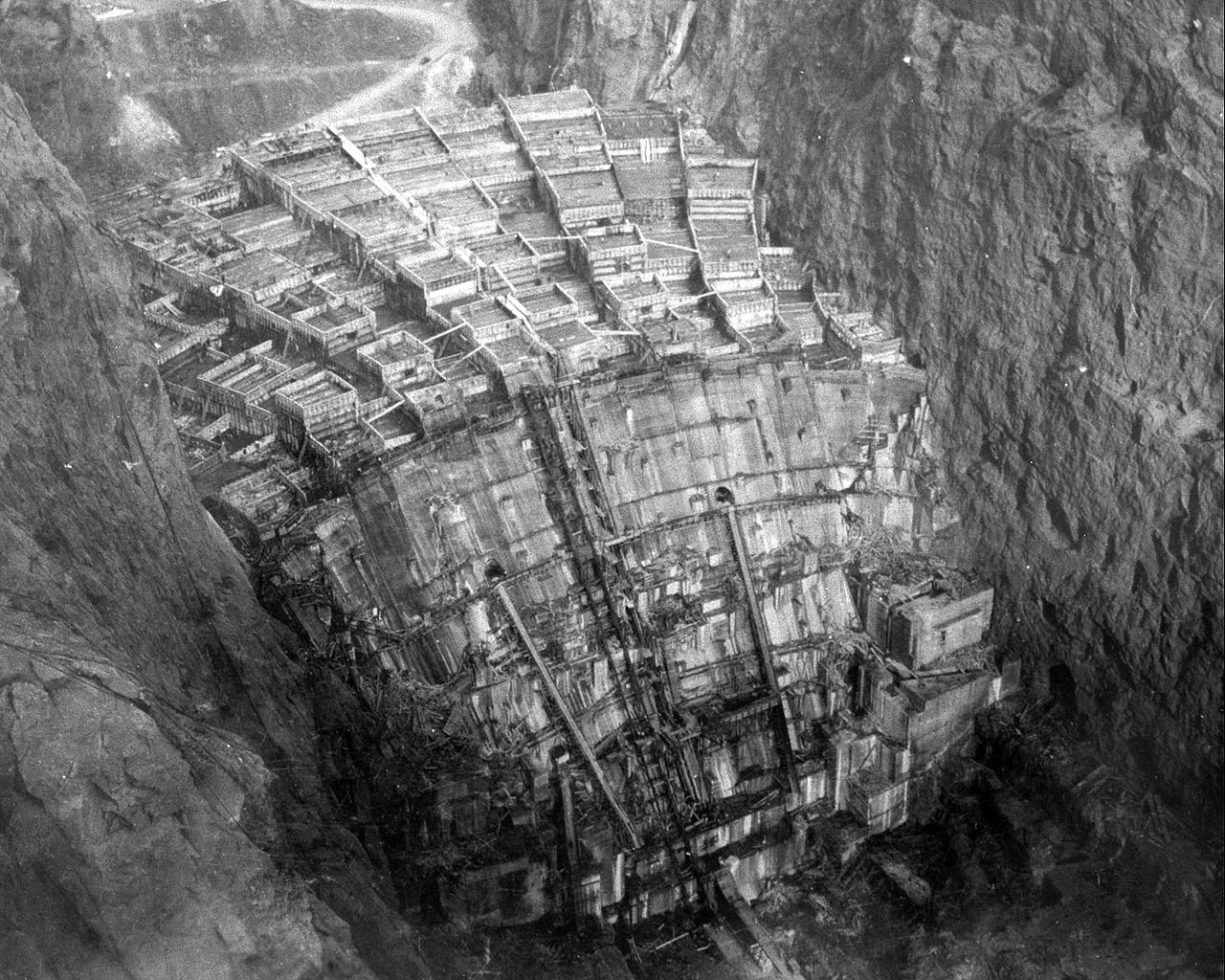
This image from WIKI shows the dam from the back side prior to complete flooding.
Oroville Dam is an earthen dam that doesn’t require the Rigid Support given by rocky walls that allow for the Concrete to be utilized. It depends on mass to do the job. 77M cu yds of soil and clay
Here is another image of Hoover Dam under construction.
It required vast ammounts of structural steel and concrete to create
A total of 3,250,000 cubic yards (2,480,000 m3) of concrete was used in the dam before concrete pouring ceased on May 29, 1935. In addition, 1,110,000 cu yd (850,000 m3) were used in the power plant and other works.
EM, as you watched it being built, were you also there for the 1955 Christmas flood that was a large part of reason the dam was built?
@Gymno:
Yup. Not very old then, but I was there.
I was also there about 1961? when a lot of flooding happened and remember riding (in a ’56 Chevy wagon, IIRC) toward Marysville and seeing a sea in all directions about 6 inches lower than the roadbed…
And about the same time when the river was about 2 feet from overtopping the levee and putting my home town under a few feet of water, and…
IIRC, Olivehurst flooded and lost a bunch of homes then.
After the dam, nobody talked about the river and flooding much any more…
They were parked on the 4th slab after the bend in the race where it increased in pitch. The cracks were between the 4th and 5th slabs. If they had parked on the 5th slab you might be correct in that they might have damaged it if it had been undermined already. The 4th slab did not shift under the weight since the earthworks below it continued to be solid. The cracks allowed water to flow under the 5th slab and scour out the earthworks under it over time it appears. The 5th slab collapsed into the resulting sink hole and more flow scoured out the slabs downhill. I am told that a good job of pressure caulking the joint between the 4th and 5th slabs in 2013/14 or even later might have made all the difference in the world.
To err is human, to screw it up totally takes government.
“…bags of marbles…” That’s pretty funny!! Meanwhile, moonbeam keeps pumping billions into the HS train to nowhere, and demanding a federal bailout for the dam….
Duzz? Just when you thought you’ve seen every example of US public education.
As to 4 pickups causing the failure of a foot thick reinforced concrete slab; Really? 10 tons total or 2,400 gallons of water or less than 1/4 of 1 percent of rated capacity.
assuming a decent subgrade, you could roll a 747 over it. Failure was likely due to vibration from the water stream causing cracks that led to the slab being undercut. There is little in the engineering world more powerful than running water.
Cavitation. The energy released from trillions of water bubbles bursting every second with the massive force of moving water behind it. A concrete spillway that hasn’t had any maintenance in years will develop small cracks. Cavitation can tear it to pieces.
That water running at high velocity down the regular spillway must cause enormous lift as it reaches the area of the damage, where the slope increases significantly. Think of air over an airplane wing. A competent physicist (not me!) can calculate the lift and compare it to the weight of the concrete slab. Add some vibration and the slab could really suffer abuse.
The main spillway is maintained pretty regularly. And, it consists of considerably more than concrete and chicken wire. When the bottom went, there were large pieces of concrete being thrown 40 feet or more in the air. The problem is that the spillway doesn’t see too much use. There are things going on underneath – water flow, erosion, chemical weathering. The maintenance works simply identifies cracks and tries to repair them, but over time, short of ripping out the spillway and rebuilding it periodically, the decay will cause failure. No tax payer in SoCal or farmer in the Southern San Joaquin Desert wants to actually pay in taxes what “their water” costs the north state. Heck, that was why they voted down Jerry and his peripheral canal the first time he was governor.
I hope the people downstream from the dam luck out. Pity there is no way for it to flood, lets say, Berkeley.
It would be their first bath ever.
Threadwinner!
A 250 mb wind speed map is not the best indicator of where the moisture is. That map shows wind speed generally around 10-10.5 km above sea level.
>blockquote>A 250 mb wind speed map is not the best indicator of where the moisture is
Try this then, and select precipitation https://www.ventusky.com/ somewhat less terrifying. But still far from reassuring. And remember that it’s only showing where precipitation is today, not where it’ll be in a few days.
Mucho gratias, that is a great resource.
Well, at least the Delta Smelt will be thriving. That should make Nancy Pelosi happy, bait fish are more important than people
I understand that when they last surveyed for the delta smelt they found 6 fish. There are some non-indigenous cousins out there though.
Apparently they have thousands in hatcheries for ” Research purposes”. But I don’t know for sure is there someone that knows? How these little guys survive in these kind of events in the first place ? I would suspect their habitat would be severely compromised in extreme cases like this.
Okay I went on Google and found hundreds of articles on this tiny fish, it has info on the hatchery and what it is trying to accomplish and it is not only about the smelt.http://www.chicoer.com/article/NA/20150417/NEWS/150419720
Forgot to add the article is from 2015, sorry.
Lol, I copied this from a page that promotes and follows DNA mapping of all of these known fish. “The fish exerts such force on the Delta’s waters that the U.S. Fish and Wildlife Service regulates how and when pumping can be done to protect it and other imperiled endangered species. Since the smelt is protected under the Endangered Species Act, a federal court order can — and has — reduced pumping to farmers and cities in Southern California. Yet this protection hasn’t been enough for a species that lives in the pipeline of California’s critical hydraulic system.”
Guess fish has a better chance then the people.
A contributing factor to fill the lake in January-February supported from the ‘which-craft’ permanent drought.
Most of that moisture looks like it will fall as snow not too far up the mountain from the dam, so that’s a good thing.
The really, really scary weather event would be torrential warm rains that melt the snowpack. That’s not too common in California, but not impossible.
Heck, in the Houston area 11″ of rain in a day is not that uncommon.
There is a track record, by the way, of dam emergency spillway problems.
Hoover Dam, 1983:
https://www.usbr.gov/lc/hooverdam/history/essays/spillways.html
The emergency spillway suffered major erosion and had to be repaired and improved.
Canyon Lake Dam, Texas, 2002
http://www.cceo.org/flood/flood2002.html
The spillway suffered significant damage and had to be reinforced.
As it was, roads and a bridge, as well as a neighborhood, were damaged significantly.
And those dams were built a lot better than Oroville.
At least the Hoover dam was with genlus Frank Crowe.
Canyon Dam is 224 feet high, while Oroville is 770 feet high (about three times as high). Otherwise construction is much the same. At max CD contains 382,000 acre·ft. Oroville holds 3,537,577 acre feet (9.2 times as much as CD). Both CD and Oroville are “earthen” dams. Hoover Dam is a concrete arch dam in a desert. Both have spillways that were damaged by outflow. So, better in what way? The time between rain falling that will enter the impoundment and and the dam actually beginning to fill has a considerably greater lag than Oroville experiences.
@hunter
“Heck, in the Houston area 11″ of rain in a day is not that uncommon.”
It sure ain’t!. I drove my Prius through that mess in May 2015 and lost the engine a few days later. It died in front of the new Whole Foods on Post Oak.
Damn Cliff, lost the Prius in front of Whole Foods. How ironic.
Badly constructed emerg. spillway will self destruct when put into use. That is why they are overusing the already damaged spillway which is cutting its way back to the lake. When the rain and melt come the whole system will blow out and immense amount of water will be released. I am so sorry, watch out below!
Sandy, My understanding is that the emergency spillway is where it is because there is a ridge of competent bedrock there. The material downslope is less than ideal, but at least the Feather River probably won’t dig itself a permanent new canyon bypassing the dam if/when the spillway is forced into constant use. … Probably … We Hope.
I’d know more if I could find the geological assessment for the dam on the internet somewhere. I imagine it’s out there somewhere, but I couldn’t find it. Also, IANACE (I Am Not A Civil Engineer).
After 9/11 a lot of previously available information was scrubbed from many sites.
I had used some plume modeling software in a GIS class. I was modeling a chlorine spill that had happened near San Antonio and overlaying it in my city to show possible effects if it happened there.
Many internet sites that used to have specifications on rail cars specifically tank cars, went paranoid and removed info like tank thickness, etc. I had to search quite a bit to get some of the information I needed.
But when I contacted the EPA for some specific info on the size of the hole in the tanker car to calculate spill rate for the modeling they gave it to me no problem.
I wouldn’t be surprised if info on dams, bridges, etc were cleansed too.
Correct … the builders spent extra time and expense in building the foundation for the emergency spillway – digging down up to 10 extra feet and back filling with concrete to insure competent bedrock for the foundation.
The ogee weir spillway is massive – 60 feet across the base and over 50 feet tall. A quick estimate I came up with was 80,000 to 120,000 tons of concrete in its 900 appx feet.
The weir wall has rubber backing on lake side, drains cast into the bottom, a 12′ x 6′ “key” in the bottom on lake side, and a 6′ thick 12′ wide apron on the down slope side.
The material on the bench between spillway weir and the access road to parking lot is weathered bedrock on surface. but with a significant part of the weir underground then adding bedrock foundation – any surface erosion of weather rock is unlikely to affect the bedrock or weir wall.
And indeed after the quick initial evacuation call – which was based on what appeared to be rapid erosion headed to toward the weir wall … soon after that erosion slowed to a stop (presumably as the loose weathered rock was scoured away).
As far as the hillside below the emergency weir – it performed perfectly. The water from the emergency weir concentrated into primarily one channel … that channel suffered minor topsoil erosion but no appreciable significant erosion. A view of “after” pics shows a green-blue color for the entire channel … meaning good, hard, unweathered bedrock.
Yes, that is my opinion. I move dirt a lot with machines. It is obvious the dam was poorly supervised and fear of a phantom drought led the operators to allow too much water. They are now frantically dropping the water level but if we have more major storms and then fast snow melt, that dam is doomed.
This mess results from the “tyranny of the majority” I have been trying to explain to my Democrat friends. The Nation escaped this tyranny in 2016 because the Electoral College worked as it was designed, keeping the Democrats of the big cities from controlling the Nation. In CA, however, it IS majority rule and the tyranny of the Democrat majority is at work. Result: Big city Democrat water agencies in Alameda and Los Angeles Counties refused to pay the cost of upgrading the overflow spillway with concreting the hillside 10 years ago when it was recommended by a study, ironically supported by the Sierra Club and Friends of The River who, if they had their way, there would be no dam at all. Anyway, this mess is the result of the tyranny of the majority, putting the safety of 200,000+ people and rich farmland, valuable property and lives of–wait for it—Republicans (the main constituency of the affected area). The Democrat Party of Death marches onward. Crazy Trains and Delta Smelt are more important to them in their immoral greedy minds than the pathetic worthless lives of the Republican minority. This sort of deadly water greed will bring revolt. Mark my words.
The DAM will not be doomed. It is competent and will NOT be overtopped. The spillway is lower.
The SPILLWAY is at risk of destruction. It is built on the other side of a natural hill from the dam. It goes under many feet of water before the level comes near the top of the dam.
It is soft rocks subject to erosion for an unknown depth, then hits hard bedrock to 1500 more feet… so at most it erodes a V of some depth in that dip in that NATURAL hill. After it does so, the gap can be filled with cement or landfill as desired… and NONE of that involves the dam at all.
What the graphic also illustrates is a river of energy flowing up into the atmosphere and then out into space. All that latent heat of vapourisation sucked up from the surface, put on the stratosphere express and just farted back out into space from whence it came.
Take that green goblins, shove your global warming frightbat hypothesis where the sun don’t shine and only very, very limited neural activity is required.
Baaaa went the Greenfleece sheep.
Boating on the Californian floods 150 years ago-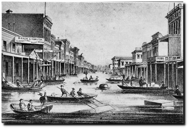
And that is why Sacramento has a level below the current street level, that used to be the main streets. They backfilled the downtown area, and used the old walls as foundations for new construction. Some of it has been excavated and provides for fascinating below-ground tours.
It will go on for a while, too. In April of the next year, Confederate Army scouts were quite sure that they had sighted the Pacific – when they were actually still well east of the Colorado. The lower Gila River has a very large floodplain.
Fortunately, the Salt River system of dams is only at 62% overall capacity right now (that watershed is the biggest inflow source for the downstream Gila). About 750,000 cf can still be accommodated.
Keeping an eye on it, though – last time we had a cycle like this, Phoenix had one bridge left standing…
During the early 1830s, the entire lower Sacramento River valley reaching north past the Sutter Buttes was under water. The Buttes themselves were essentially an island connected to dry by a narrow neck to the northeast. The entire animal and human populations of the lower valley had moved out to live with their relatives. There’s a very thorough account in the diaries of John Work of the Hudson’s Bay Company. While that period is not listed as an “historic” flood, it was likely greater than or equal to the “historic” floods 20 years later. Work’s trip coincided with an epidemic that wiped out about 80% of the indian population. Work describes villages with 1,000 people in them when he passed south and only corpses when he travelled back north. Work’s own party lost half its personnel to the disease.
Data like this does not give due respect to “inevitable” Carbon desertification. (wink)
This is the wettest permanent drought I can remember…..
Latitude wins the thread!
Agreed!
Worse than we thought.
I am SOoo glad there is a drought – can you imagine the damage if there were no drought!?
+1000
The lake has already risen 2000 feet in the last two months. No doubt the surface area near capacity is much grater than 2000 feet ago, but…they’re struggling to lower the level by fifty feet…with a broken spillway. Let’s hope it falls as snow and we have a slow melt. 🙁
“The lake has already risen 2000 feet ….”
Are you sure?
How high is the dam?
770 feet. Maybe he meant thousand acre feet of water before last weeks storm. The lake holds maximum 3,500,000 acre feet when full.
Sorry, yes: http://cdec.water.ca.gov/cdecapp/resapp/resDetailOrig.action?resid=ORO
Most intersting is to show all years. We are months below peak snow melt with 2x normal snow pack. Is there any reason to have allowed the dam to fill at this point?
“2000” feet
At a guess, there’s an extra zero there. 200 feet seems sort of plausible.
770 feet high
(Clarifying again) Oroville dam stored water increased from 1,500,000 in early December to over 3,500,000 acre-feet in just over two months. They managed to reduce it to 3,266,395 over the last few days, with no rain. (My brain has been turning those numbers into shorthand of thousand acre-feet. My apologies.)
http://cdec.water.ca.gov/cdecapp/resapp/resDetailOrig.action?resid=ORO
Ashby
February 15, 2017 at 2:04 pm
…
Most interesting is to show all years. We are months below peak snow melt with 2x normal snow pack. Is there any reason to have allowed the dam to fill at this point?
Yes, indeed. The Governor’s friends in Southern California are profoundly frustrated by the snail darter in the delta. They want assurances that we here in the north won’t waste any of “their” precious water protecting some who-cares farms and cities up here. So they always feel insecure about floods and fish. As regards the fish, king (Chinook) salmon are a much bigger issue than the snail darters, and better eating. Salmon are also economically important. Any time you see someone cranking about the snail darter and the problems it causes, you want to remember that this part of the state has the best water, the best fish, the best beef, the best grain, and thanks to Clarence Mulholland and his buddies, the best farmland. LA used to have some fine farming.
The new 20z qpf has 14.5″ u in that area.
http://i.imgur.com/i0iPTYB.jpg
Solar induced meridional / equatorward jetstream tracks are causing the wet Californian episode. Depending on the state of the sun California switches between wet and dry as the jets move north or south.El Nino also makes a contribution.
Note that the early 1800s were a time of quiet sun hence that megaflood in 1861/2. There was no El Nino at that time, nor significant human CO2 emissions so the sun it must be.
During a period such as the Maunder Minimum California would be flooded more often than not.
Actually I’ve been surprised at the lock of blocking behavior this winter. Weather systems have been moving straight across the US and we have stayed quite warm for the most part. This has allowed the zonal jet streams to bring “pineapple express” moisture into California. I’m wondering whether this is because the Eurasian continent got the benefit of the arctic air this winter and it may be out turn next year.
…lack of blocking behavior….
You get zonal sections between meridional loops.
Yes solar induced, and this is a cyclical process. That is how I pieced together that this year was the most probable year for such an event to occur back in early 2014, …https://disqus.com/home/discussion/cnbc/california_rice_farmer_039probably_sell039_due_to_drought/newest/#comment-1583227008
more clearly stated in Sept 2015, …https://disqus.com/home/discussion/cnbc/sierra_nevada_snowpack_lowest_in_500_years/#comment-2253607967
The second choice was the winter of 2017/18. If not by then, then my speculation was falsified. There is still some probability that next winter might exceed this winter in intensity. There is reason to believe so from studying the historical records, imo.
Since California seems to be a rain feast or famine state, it would have been in their interest to shore up and even build more reservoirs. Instead they released acre feet of water to save a bait fish that is clearly doomed to extinction, no matter what they do. The key to surviving in any climate is to understand it and to adapt to it.
gotta save money for that 200MPH hi-speed trip for Modesto to Bakersfield.
Bonus question: how many readers have actually been on the ground in CA central valley cities and seen the legacy train tracks?
Reply: Does staying at the Chowchilla Holiday Inn Express and being woken up by trains count? Cuz I’ve done that a lot. ~ctm
This Bakersfield?
Lived next to them (about a block away) the first 18 years of my life. Grew up jumping into water off of train trestles in summer… Tracks go right through the middle of my old home town.
Let’s all pray for enough rain to keep the water levels high enough to maintain the out flow velocity at least what it is now on the damaged primary spillway for the rest of the high level flow season. A reduction of that velocity could cause a further up stream damage/crumbling to what’s left of it. An increase may be an added safety factor. Too much fun reading the various comments from arm chair “experts” on another site. Think Physics 101. By the way, I’m one too (arm chair consultant) watching from the sidelines.
But per my comments on the previous WUWT article/post it’s time to drill the northern parking area in preparation for controlled explosive demolition. Not likely to be needed, but then MAYBE. Cheap insurance.
I need to note again in my comment above that the “velocity” matters.
You can’t drill until you’re ready to load the boreholes, otherwise given the current conditions you are likely to get water infiltration and collapse of the boreholes. And I doubt you could get a certified blaster to do a demo in this area anyway. “Liability” doesn’t even begin to describe all the badness that could come down on said individual
ifwhen something goes wrong. King Mine, anyone?WTF are you talking about? Get real on the current issue.
Hey, you’re the one who brought up explosives, sunshine.
Water carries shock waves very well.
All of the ground in that area is completely saturated.
One would have to be very, very careful blasting anywhere close to the emergency overflow.
Gosh, MarkW. What if a nice big earthquake struck N. Cal. just now? Blimey!
So … do you claim that it has never been done? Aughaaa ………
very, very, very, very careful. There fixe it for you.
eyesonu . I am asking a serious question. What is the reasoning behind blasting the parking lot? Would the chance of disturbing that ground next to the existing emergency spillway not add to the problem? As far as I can tell from the history of the dam the parking lot was added after the construction of the dam. I wonder if those builders and inspectors thought the emergency spillway would be enough in an emergency and never took into account that this would happen. I guess what I am trying to say is that the spillway should have been extended past it’s 1700 foot length and beyond the parking lot in the first place.
So again, why blast it?
The parking lot is part of the design of the Emergency Spillway.. The Regular (concrete) spillway already extends past the ‘parking lot’ but some hundreds of feet away from it and below current water level. The peak (start of the top) is set by NATURE as that is the top of the NATURAL rock ridge.
Blasting anything would be on the incredibly dim side of silly. This EMERGENCY spillway structure was designed as a last resort overflow to save the dam and it is much better to have it slowly erode the ROCK face it is built out of than to blast a hole in it, compromise the engineered structures, and start a massive more forceful erosion.
Please folks, study some photos of the area and at least get the basics of the parts names and locations before suggesting things be designed differently or blown up.
Note that the EMERGENCY spillway has two sections. The first is a 60 foot tall by 60 food wide at the base concrete 1/2 oval. It is designed to take spillage first. Uphill from it a ways is a 4 foot square or so concrete skirt on the edge of the parking lot. It is designed to take flow as the depth increases. It is my opinion that this may well have been designed as a slow erosion plug to lower lake level in the event of an EMERGENCY need (i.e. normal flow + regular spillway at 250,000+ CFS and the lake is still climbing by 20 feet…) and the notion they could use it as a modulation / controlled spillway is just them not understanding the original design goal: Save the dam by sacrificing the top 50 feet of the ridge and flood gradually low lying valley areas, but prevent uncontrolled release of 900 feet of water.
I’d ask the design engineer what they had in mind, but that was 50 years ago and I doubt he’ll answer.
asbot,
The concrete weir is about 900 ft long extending from the primary discharge spillway to the parking lot. From the parking lot to the face of the mountain where the land rises steeply is about 800 ft. The parking lot is at the same level as the top of the concrete weir and functions as part of the emergency spillway, but that area is much wider (from lake to drop off into river valley below).
If a historically heavy rain were to combine with melting snow pack and some catastrophic issue shutdown the primary spillway water could conceivably top the emergency spillway by tens of feet. There were some unforeseen issues at 1.5 ft. Who knows what 10 ft would do.
The idea of pre-drilling a grid to open an emergency and controlled breach/canal in the event of a nightmare scenario with extreme overflows would be good insurance. Cheap too. You don’t have to blow it open unless necessary. A controlled fracturing of the rock and water flow will remove the debris via fairly rapid erosion. There will most likely be another gated spillway placed there anyway, but it will not be finished anytime soon yet hopefully before it’s needed.
Sort of like having a spare tire or firearm for self defense, hope you never need it but don’t want to be caught without it if you do. Especially if time is of the essence.
@eyesonu
I’ve told you before, you can’t pre-drill the blast holes given the current conditions. The holes will collapse. If you try to pre-load the holes, the explosives, caps, or boosters are likely to water log and fail.
D. J. Hawkins,
There is no need for you to “tell me” anything. I do not listen to anyone that does not have enough sense to figure out how to drop a piece of plastic pipe in a 15 – 20 ft deep hole to line it. Please, there is no need for you to respond.
@eyesonu
You really thought that was going to stop me, I’m sure. Of the two of us, you’re not the one who carried the title “Explosives Development Engineer” after his name for six years so peddle your “armchair consulting” on this elsewhere. Really, just do yourself a favor and button it up.
@eyesonu:
Listen to D.J. Hawkins, he has clue about explosives. Yes, you could place waterproof explosives, but it would be incredibly dumb. The emergency spillway was engineered to work. Adding explosives will NOT improve it. The original design docs say it is expected to take damage if used. That tells me they expect it to have natural and moderate erosion. Blow that up you get no clue what happens.
My background? Well, Dad was a Combat Engineer in W.W. II and taught me about explosives. I’ve created several explosives from scratch (including one using a T shirt, battery acid, and fertilizer… just to prove it could be done) and I’ve blown things up a few times.
Not pro level, but enough to know something about it. (My favorite is one made from copper and welding gas… the explosion products are atomic metal and carbon… )
Generally speaking, blowing up engineered structures does NOT improve them. Having rock slowly erode is better than a fractured bed prone to rapid failure and washout.
I’m surprised the ground under the concrete spillway was not sprayed or coated with a bentonite and mag chloride or similar chloride stabilization. This is what is used in many cases to prevent water, toxic chemicals and other liquids from permeating ground soil. A lot of dirt roads are sprayed with this as well to keep down dust.
Unless the ground see constant wheeled traffic, a single coating is enough to make the top soil impervious to water penetration for extended periods of time. For example, run off ponds typically have a layer of this applied before the physical barrier is laid down. Seems like cheap insurance to me.
Bentonite is a volcanic clay is it not? I use it to clear wine. It expands terrifically when I add it to my musts. I can see its uses it Hydro stuff, sort of expanding foam. Yes? No? Shut up Rocky?
RS
It also ends up in some shaving soaps. However it has NO ability to dam the flow of blood from an ooopsy-daisy.
Bentonite is common cheapo kitty litter to me. I do notice its volume expands dramatically after absorbing a week’s worth of cat urine.
I don’t know about volcanic clay, but I do know it is a clay and around Denver there are pockets of it where you should not build a home because it has cracked foundations. You are correct about it’s ability to expand with very high pressure when exposed to a little water.
I use it as well for my wine making.
I can’t imagine though a thin layer, when mixed with Mag Chloride would expand that much.
Used bentonite to reseal my farm pond after we rebed the earth dam spillway pipe system in concrete due to agreesive seepage outside the pipe, 6 inch void by themtimemwe dug it up, just like what undermined the main Oroville spillway on a much bigger scale. My stockpond is 1 acre and holds maybe 4 acrefeet. My brother used it to seal his artifical up mountain swimming hole at his stream fed NC mountain retreat. An amazing clay. Shrinks dry, swells waterproof when wet.
Bentonite slurry is thixotropic. Used in civils as a temporary support fluid during diaphragm wall construction, pretty standard stuff for decades in appropriate situations. Here’s a natty little dam oriented animation which doesn’t mention RC cage placement, tremie pipes or the usual filtering, handling and disposal issues. Should give you the general idea anyway (think big mess). Not much use here, the good guys’ game is erosion abatement and quickly.
Used to line ponds before filling them. I don’t know how well it’d stand up with flowing water though but in static pond situation it is used regularly. Dust the empty pond with dry bentonite and slowly fill. It works quite well.
Officials at the Dam said that they need to lower the reservoir level to 50 below topping to avert collapse of the emergency spillway in the event of the impending rain storm.
Based on the rainfall coming, the time it takes for the watershed to transport the rain to the reservoir, and the amount the reservoir will drop, is it likely the engineering team will prevent a partial collapse?
Anthony, you were way ahead of this issue 2 weeks ago. I suspect that you can make an educated guess on the reservoir rise and the timeline.
Have you a forecast?
Auburn Dam would be a nice safety net for Sacramento, to bad the Greens killed the Dam.
Had they built the Auburn Dam, the Oroville Dam could have been used purely for flood control, as intended. Instead they had to try and use it for both drinking water and flood control. Two conflicting requirements.
Oroville dam was NOT intended just for flood control. The dam is part of an integrated state project to take water from Oroville, with pumps near Tracy and place the water into the State Water Project canal that runs to Wheeler Ridge, south of Bakersfield. There, huge electric pumps pick the water up and through tunnels, canals and lakes, and eventually to Los Angeles and Southern California where it represents their main water supply. The weak spot in this whole issue is the SF estuary (Delta). If enough diked islands break and water intrudes, salt water intrusion from the Bay will be pumped into the State Tracy pumping plant and that is “game over”.
Here in California they have told us that we are in a mega drought so we must save as much water as we can. I myself save rain water from my roof to be used later to water the garden. But I have run out of water stroage capacity, parts of my garden has become a bog, and we keep getting more rainstorms. I cannot keep open containers for very long for fear of mosquitos. They have been telling us that it will take years to refill the water table so we need to save all we can to inject this excess rain water into the ground.
What we are experiencing today are part of the current climate. If some how the powers that be can actually hault climate change then they will lock in the current cycle of floods and droughts.
Put screens on the rain barrels. I lived in a tent for ten years and this is how we stored water, the barrels were under the forest trees and we piped the rain water to it, the screens keeps out leaves, etc.
Anthony, Great post as usual! I like on eastside of Oroville and am not in immediate danger, but I’m trying to let everyone I know to be prepared. The DWR knew about the weir problem and still let the problem happen. They could have released more water down the spillway, which they did when it almost failed. Their judgment is not to be trusted. We could well be in the “eye of the hurricane” with the respect to the current emergency.
Don’t sleep in a canyon when a storm is approaching. Your situation is similar. GK
No worries. I live above the lake level. Nonetheless I have provisions and am ready to bug out should the worse happen. Thanks again.
Take care of yourself, Mr. Adams! Do report back in a week or so, okay??
Actually Do, report back every day for the next few days once the storms hit, And as far as bugging out ? Would that not mean going down into the valley to use roads ? You get seriously get caught up in a jammed highway with nowhere to go . If you are currently higher that the dam would you not be better off staying put with the supplies you have for a week or so? Or is there a “back ” way out in your case?
Actually Don, (sorry typing to fast)
After a four-year drought, California has been battering the CAGW air-waves with complaints about lack of rain for so long that Nature has tired and has staged a Super-soaker: Atmospheric River, aimed at Oroville, to demonstrate what it can really achieve when it is really pissed off. Californians should visit Australia to see evidence of real ten-year droughts followed by flooding rains.
Karma?
Remember a third of us are Trump Patriots. Unlike many califreekafornians, who bailed, we stand our ground. We ain’t scared of the socialist rats. Bring it on
Gaia just decided that all these CAGW apocolypsists were disturbing her vacation time, and decided to show them she could perfectly well take care of herself without any help.
For some reason, this website (weather.gov) predicts MUCH lower rainfall amounts (as of about 5 minutes ago) for the Oroville, CA area:
Wednesday, 2/15 — up to half an inch.
Thursday, 2/16 — up to three quarters of an inch.
Thurs. eve — less than one tenth of an inch.
Friday, 2/17 — no measurable amount given.
Sat. – Tuesday, 2/21 — “chance of showers” only
Adds up to approximately (using worst case scenario): ~ 1.4 inches
(cite: http://forecast.weather.gov/MapClick.php?lat=39.51377593300049&lon=-121.5563599089997#.WKTLLm8rKpo )
When I lived in CA for a couple of years recently, I often got a good laugh when looking up the weather online. The rain graphic is the same as that for Washington, my home state. Oooo, very, very, dark, threatening dark grey clouds, rain pouring down in buckets. I’d see those little pictures and my spirits would fall, “Oh, BUMMER. Rain! I came here to get away from rain!” Then…….. I would read the details below. OFTEN the amount of rain was “less than 1/10 inch” or “1/4 to 1/2 inch”!! I laughed. If it said, “showers,” that was almost always “no” rain.
So! My guess, based on the experience I have had with the reliability of that weather site (very good), Oroville will be just fine.
The threat of heavy rain is to the east of the reservoir in the mountains and foothills. The amount of rain in the town of Oroville makes almost no difference at all.
Thank you, Bill J, for the instruction about pinpointing a more relevant forecast.
FYI: The area covered by the forecast in my 1:56pm comment goes beyond the borders of the town and includes “the Oroville, CA area.”
This one, for the Feather Falls area, north and east of Oroville, CA says (about 10 minutes ago):
Wednesday, 2/15 — .75 to 1 inch.
Thursday, 2/16 — 1 to 2 inches.
Thurs. eve — less than one tenth of an inch.
Friday, 2/17 – “showers” no measurable amount given.
Sat. 2/18 — “chance of showers”
Sun., 2/19 — “rain likely”
Mon., 2/20 — rain turning to “showers”
Tues., 2/21 — “showers”
Adds up to approximately (using worst case scenario): ~ 3.5 inches
(In my experience, the weather.gov site errs on the side of caution (though not 100% correct, of course) and OFTEN the rain/showers when I was in CA never happened at all or were much less severe than predicted).
(Source: http://forecast.weather.gov/MapClick.php?lat=39.59321638400047&lon=-121.25634903099973#.WKTZd28rKpo )
A significant increase, but, still not nearly as much as the other website is touting.
So! 🙂 My guess remains: Oroville and the surrounding area will be just fine.
Janice click on the link you posted and then scroll down to “Forecast discussion”. You’ll find the following:
A more substantial system arrives late Sunday night/early Monday,
coupled with a fairly strong moisture plume. This looks like the
wettest storm of the forecast period, though compared to the
storms of last week this will be a much less impressive system.
Liquid equivalent amounts of 3 to 6 inches are possible over the
mountains, around 1 to 2 inches in the Valley. There is some model
disagreement as to where the main brunt of the storm will be
focused, north of I80 over the Feather River Basin (GFS) or south
of it (ECMWF) & (GEM).
And that’s just from the second system.
The California Nevada River Forecast Center has responsibility for forecast precipitation in the region as well as forecasting river flows and they expect 8 to 10″ of rain over the next 6 days in the mountains around Lake Oroville at elevations below the snow level. Above that they expect up to 10.5″ of precip.
http://www.cnrfc.noaa.gov/ then click on Forecast Precipitation (QPF)
You can also check out the QPF charts from the WPC such as this 7 day QPF:
http://www.wpc.ncep.noaa.gov/qpf/p168i.gif
Thanks for the instruction, Bill J. 🙂
Re: “liquid equivalents” that would likely be snow in the mountains and, since no sudden increase in temps. are likely, no big deal vis a vis the Oroville situation for the next 2 weeks or so.
(from the “Forecast Discussion” you so kindly directed me to):
Your conscientious attention to keeping me within the realm of accuracy is appreciated!
Janice, the same here in BC lots of snow warnings etc between us and the coast and then those snow events do not happen, so people get complacent. Last week many people decided to cross over to the coast anyway and a snowstorm hit with 1-2 feet of snow. Mayhem!! Stranded people everywhere and lots of accidents but what was so stupid many travellers were without any food, water or any survival gear at all in the dead of winter! Stunning and of course they blamed the government for not “protecting” them from winter hazards!
Hey Janice! Where did you get your Meteorology degree? Mine came from UC Davis. I’m fairly certain from your comments you are not from the area and don’t have much knowledge of past events or the watershed feeding the Feather River. Anthony isn’t the only forecaster predicting large amounts of precip over the next several days. There is over 2.8 million acre feet of water contained in the snow pack above us (the total capacity of the dam is 3.53 million acre feet and as of now there is about 200 k acre feet left to fill). All it takes is a warmer than usual storm like last week’s or in 1997 for that snow to suddenly melt and overwhelm the capacity of the Oroville Dam or the levees downstream on the Feather River to contain the flood. So even if the probability of a warm rain is low, say 10%, the impact is astronomical (In 1997, the river flowed in excess of 300k cubic feet / second and just last week it peaked just below 195K cubic feet / second). Not trying to determine the cost of a single human life, the potential cost to businesses, property and the environment is huge–by a dam site. Do you remember New Orleans in 2005? Do you know Sacramento is the next most at risk city of a catastrophic flood? Check you map to see where the Feather River flows.
Also every stream, creek and river ringing the valley is pouring water into the Sacramento. There is more to this than a potential disaster at Oroville.
Dear Mr. Adams,
I can see that it appears that I was criticizing our host. Good for you to jump to his defense against, yes, only a layperson, here. I was only reporting what I had read on the other site. I’m glad I did, for, it resulted in some good instruction. I thought my remarks were only potentially disparaging of the weather website cited in the above article. I didn’t realize that Anthony himself had analyzed the data and come up with his own forecast. If I had, I would likely have just not said anything. Anthony is our fine host and I am in his “living room,” here, so I try, believe it or not, to be polite. Heh.
Well. You are right. I have no local experience or historical knowledge. I am basing any guesses I make on my lifetime of living near the foothills of the Cascade Mountains, near the Skagit River, not too far from the Baker Dam and the Ross Dam (and Gorge Dam). Here, it would be HIGHLY unlikely that a sudden warming would occur within a few days after a February snowstorm such that it would cause what can happen in your neck of the United States woods:
Thank you for taking the time to let me know things are MUCH different in California.
Best wishes to you as you weather more rain and snow! Here’s to a lovely spring and all those wonderful blue skies you will soon be enjoying while I am under gray and rain until mid-July.
Your neighbor to the far north,
Janice
P.S. Yes, (smiling at how ignorant you obviously think I am, and that’s okay — I must just come off that way) I remember Hurricane Katrina and the Lake Pontchartrain engineering/political exacerbation of it. The best thing that came out of that terrible event (MUCH of the misery could have been prevented, too) was the heroic “to-the-rescue” effectiveness of private enterprise and the free market system. Home Depot, et al., got the job done while ol’ “deer in the headlights” “Brownie” stood there thinking about it and thinking and thinking (eye roll). One teenaged boy fired up a New Orleans school bus, loaded her up with poor people who couldn’t get out, and, with all of them pooling their money for fuel, drove it clear to Houston, Texas. No, I will never forget that summer.
If I have to bug out it will be for the hills to the east and south. I won’t be waiting for the official announcement either. When I received the emergency notification on my phone the first time, I was downtown and immediately began heading back up the hill to where I live. The road was congested within minutes and backed up about a 1/2 mile from my turnoff. I ended up taking a back route. When I passed the local gas mart, people were already lining up for gas. My tank will not be less than 3/4 full until this emergency is over. Thanks for your gracious reply Janice. I know Central Oregon well having driven more times than I care across the Santiam pass to Bend in the winter. Your worry should be that big volcano between you and Portlandia–it’s become a self-caricature! It’s been awhile since she blew, but the same could have been said about St. Helens in the early 80s. Bonne chance!
Dear Mr. Adams,
Thank you for responding, giving me the relief of “oh, good, everything is okay with Mr. Adams.” Your precautions reflect your wisdom (using your vast local knowledge effectively!).
Just to clarify, I wrote sloppily above (I’m Washington-centric!) and neglected to say that I was born and raised near the foothills of the Washington Cascade Mountains (near Mount Vernon). I’m flattered that you confused me with our lovely Pamela Gray (you pinpointed her location, I think).
Take care.
Your neighbor to the far, far, north 🙂 ,
Janice
Don Adams … your numbers are not accurate …
In the 92 hours since last Sunday afternoon when they upped the outflow rate to 100,000 cfs, officials have dropped the level from 901.65 to 866.75 – a drop of 35 feet. They have released 524,312 acre feet over 92 hours …
Total capacity 3,537,577 minus current level 3,039,414 equals 498,163 current available capacity. That number will increase as they continue outflows.
The avg outflow last 24 hours is appx 6100 ac ft/hour – at 100,000 cfs. Operators have enacted a planned reduction to 85,0000 cfs – due to levels reaching the top of the main spillway intake channel cut – so as not to cause erosion in the intake channel.
Flood control elevation 850
Capacity at 850 2,808,349
Maximum capacity at 900 3,537,577
Reserve at 850 729,228
Current Elevation 866.75
Current capacity 3,039,414
Current reserve 498,163
Estimate in/hr at 85,000 4.17 inch/hour
Est time to 850 at 85,000 48.16 hours
During the major rainfall event in early Jan 2017, I believe appx 15 inches fell in the area. During the appx 18 hour peak inflow period on 1/8 and 1/9 inflow rates averaged appx 135,000 cfs with a peak of appx 155,000 cfs.
Significantly increased inflows (60,000 cfs and higher) ran from the morning of 1/8 thru midday 1/11 … reservoir level was appx 793′ on 1/8 and appx 842 midday 1/11 … an increase of appx 49′ … or appx 676,740 acre feet.
There was no appreciable outflow during this entire 3 day period.
We currently have appx 500,000 acre feet of storage available – and should have more than 700,000 by Saturday.
There is currently enough storage to handle nearly 75% of the inflow from the current storm … and even IF it is as STRONG as the January one … in the next 48 hours there should be enough available storage capacity to handle 100% of the inflow from a 15″ January type super storm … without running the spillway at all.
If you are going to chastise others it helps if your own facts are accurate.
data:
http://cdec.water.ca.gov/cgi-progs/queryF?s=ORO&d=16-Feb-2017+13:39&span=92hours
@ Janice take a look at this. This is the highest concentration of moisture TCW, and is close to double the density of any storm this entire winter. It looks to me like it will come in by tomorrow into my area which is 100 miles ENE of Oroville. This should be a dump of water. Also take a look at the TPW measurement which is at 40 kg/m2. Again the heaviest atmospheric flow of this winter to make landfall. …https://earth.nullschool.net/#current/wind/surface/level/overlay=total_cloud_water/orthographic=-151.91,28.34,497/loc=-126.780,37.700
goldminor: Thanks. You may be right. Take care of yourself out there in the mountains! Janice
It has been 7 hours of non stop pouring rain around here. I got a little excited about that TCW concentration. It must have been the moisture getting compressed as the offshore flow came up against the coast last night. The highest reading was 5.0 kg/m2, and I thought the earlier 2.4 kg/m2 was high. The only other time where I saw that high a TCW reading was when looking at a cyclone coming into Australia. Mendocino Co to the south of me and on the coast must have received a deluge from that. I am cozy warm with the cats running around, or at least for as long as the power stays on. Here’s hoping, there have been a few blinks of the lights.
I’m sort of wondering if dam spillways are an afterthought in dam construction. The least glamorous, no glory part of the dam. However they decide to build the dam, the spillway design crew has to deal with it and finish the job just as the construction money is running out. Sort like how spent fuel storage, sometimes referred to as the ### end of the nuclear fuel cycle, is the least glamourous part of nuclear plant design. Nobody thinks much of each of those until a potential disaster occurs.
It all reminds me of the boat ramp at our local lake, the parking lot and facilities are all great but the poured concrete boat ramp entering the lake, arguably the most important part of the entire place, was just lousy, crooked and broken up. So the county finally got around to “fixing” it, they put a low budget crew of high school summer workers in the job who basically poured a few yards on top of the existing mess, no forms or anything just a blob of concrete. It’s now way worse than it was …. sometimes it’s best not to complain lol.
Where’s Joe Romm?
That reminds me. Guess who reared his ugly head on to discuss the travails of the dam on “The Ten O’Clock News” (Oakland) last night? Peter Gleick! And not a word about climate change, I kid you not.
Looking for Waldo I suspect!
They’ve got a long hard row to hoe when it comes to fixing the problems. Unless the situation has changed lately they can’t even use generation to pass water from the reservoir because of the water level in the retention pool at the dam’s base and the fact that they disconnected the powerhouse from the grid and the generators cannot be run without their output being distributed. There have been tons of debris from the erosion around the spillways deposited in that pool and they have to deal with that. They’ll have to drop the lake below the spillway intake, the approximately 50ft from full pool that they’re planning on, and even then they can’t be assured that the main spillway will be unused while the repairs are underway unless they have the emergency spillway in a completely stable condition. They’re juggling hand grenades with all the pins pulled. Good luck and God bless all the people downstream who’ve paid their salaries and depended on them.
Boil lake water with the generated power. It will help lower the level. This is a very silly but somehow attractive concept.
I think it’d take a leetle more energy than that to boil off even a small part of a 25 square mile lake. 🙂
Might do better with bucket brigades.
Remember in my youth the stage electrician using a bucket with lowering electrodes in it to dim the lights using 240volts mains. Surely the dam could be used to take the output of the generators so the so the exhaust water would contribute to lowering the dam level ?
With min temps following dew points, is it any wonder we’ve had such a warm winter, look at that water coming.
The remnants of Hurricane David dropped 1/4 to 1/3 the vol of Lake Erie on it’s trip from the gulf to Canada
The MetaBunk professional forum below has pretty well established that the emergency spillway will breach when used again. The current incoming storm’s outcome will depend on how effectively the main (but cratered) concrete spillway dewaters the reservoir. That is very much a factor of how fast and long the rainfall enters the spillway.
https://www.metabunk.org/oroville-dam-spillway-failure.t8381/
See that forum’s pages 12-16 discussing weathered bedrock.
And we still have a month of rain coming in. A warm rain will melt some to a lot of the @ 2.8 million acre feet of snowpack in the Oroville watershed pretty fast. This won’t be over until May.
Here in the NE upstate NY region, we generally get steady weather except with the el Nino/la Nina cycles. California, on the other hand, is mostly dry with ‘good years’ of nice rain and terrible droughts with immense, nearly unimaginable amounts of moisture that would make Noah cringe.
It has always been like that. During the very dry 1930s, all the movies were made there due to dry weather. Then it got wet again! They were stunned by this, never expected it. Well, that is how California always has been.
One can see how much the last storm brought to Oroville Dam and do simple math on the draw down in this link. If the storm is anything like the last one, you will have intense pressure on the system.
http://cdec.water.ca.gov/cgi-progs/products/orores.pdf
What concerns us even more is the inability to draw down Shasta as well, even with very heavy releases. The Northern California water system has two main dams which include Shasta (more west) and Oroville Dam (more east, for those that may not be familiar with the area.
http://cdec.water.ca.gov/cgi-progs/products/shares.pdf
It seems to our group that the whole system will be greatly stressed and that there is real risk of Sacramento City and the regional area flooding. Many levees are already showing stress water leaching today. This is the wettest season in recent recorded history and one should be expecting rare events to occur….
http://cdec.water.ca.gov/cgi-progs/products/PLOT_ESI.pdf
Jeremy, you are entirely correct. The Sacramento area levees have enough problems this year without any pulse coming down from Oroville.
They opened the Yolo bypass around 4 days ago for the first time in some years. The Sacramento must be flowing a lot of water by now.
The picture below shows the primary spillway after the initial erosion was reported 2/9/17. You can see water spraying out of the sidewalls at regular intervals into the primary spillway. That water is coming from drains installed to relieve any hydrostatic pressure that may occur behind the sidewalls or under the concrete slabs of the primary spillway bed. Given the volume of water spraying from each drain on both side walls above the main bed failure, there was/is a lot of water moving under and around the sides of the primary spillway structures.
The hole is now completely across.
Has WUWT been caught sleeping at the wheel? I would have expected this explosive news to be reported here as a scoop!
http://www.climatedepot.com/2017/02/14/supreme-court-justice-samuel-alito-carbon-dioxide-is-not-a-pollutant/
(Sorry, “Tips and Notes” page not working for me. Way too slow (too many comments) before showing “Error in page…”)
Wow, just wow, or rather WOOP YEAH, 3 cheers…..
+1. Well worth reading.
Yes, there is about a years or more of comments which need to load. Effectively out of service until Anthony clear out the dead wood.
I saw it, but it’s just not that interesting since it is an individual opinion, not a court decision.
Thanks for your response. My thinking was that it’s not every day that such an influential individual bats for the skeptics’ side. In fact, it may signal the early stages of alarmism going out of fashion!
Thanks Graham Great pick-up. That one was of course completely buried by the MSM I would think!
I forgot to add that moonbeam after lambasting Trump for weeks about sanctuary cities and States he went out Monday morning asking for Federal Aid in this emergency!
“Sorry, “Tips and Notes” page not working for me. Way too slow (too many comments) before showing “Error in page…”
It’s not too many comments, it is the page is trying to load too many scripts. Get a script blocker and the page loads just fine. I use “NoScript” on Firefox.
Thanks, Anthony. I’m working on it.
This WUWT article now linked on Drudge Report.
Foot of rain possible….
Peter Gleick also had an article in the Mercury News on the end of the drought. No mention of climate change and no scare mongering. The article reads like a common sense reminder of California’s historic struggle with water issues. Amazing what a guy can do when he’s not infested with politics.
Global Raining obviously, Let’s invest in a couple of trillion dollars in kitty litter and cover California with it.
They want to secede from the US. Let them stand alone. Trump has already declared them a disaster area. As a former resident the state, it’s always been a disaster.
Perhaps this should have been a higher priority than rapid rail?
OK, from my calcs:
Drainage area = 3,611 sqmi (from Table of Statistics). 11 inches of rain over the next ten days, equals an average inflow of 106.8k cuft/s. Since they have been releasing 100k cuft/s per day since Sunday, and will continue to do so, they should not overtop the emergency spillway.
Unless … the rain is a pineapple express, and melts a lot of snow. Pray for cold and drought, prepare for rain.
When this emergency is over and it is time to repair the spillway, I hope they don’t waste money by trying to rebuild the lower part of it. By the end of the season that will be down to bedrock and quite stable. All they really need to do is to stabilize the remaining upper section of the spillway against the possibility of undercutting. Filling that massive hole with dirt and sticking another concrete ramp over the top of it would be a pointless waste of money.
Ian + one, but you realize that would mean saving money on taxpayers dollars and the missed opportunity ( for bribes) to screw around with government contracts
They will build an entirely new concrete Spillway in whatever is left of the Emergency Spillway most likely down near the parking lot end. Then cement over the area under the 1/2 oval Concrete Emergency Spillway weir. Then repairs to the foot of the rump existing spillway becomes a tertiary emergency spillway…
I doubt it because then they have no ability to take the level down below 900′, the first priority when the rains are over would be to repair the bed of the main spillway
Phil:
I have that from the briefing from the DWR. You know, the guys in charge. They specifically said they expected to build a completely new spillway before next rain season, and the only place to do that is in the Emergency Spillway bed. Easiest part of that is the parking lot area.
They have already committed to cement “armor” of the area under the concrete weir part of the Emergency Spillway, so that isn’t a projection either, but just reporting.
The only unknown part is what will be done with the rump of the existing spillway. As repair of the entire ramp below the break is already off the table, per DWR, and “reinforcing the toe” of the broken spillway is also already stated as a goal, that too is “just reporting”. The only “guess” is that they would do more of it this summer while building the replacement spillway. That isn’t a very big guess…
So doubt all you want; but listen to the DWR briefings, as those are the guys making the actual decisions.
Also, in building the replacement spillway, they will bulldoze any depth trench they like into the parking lot area as they build it just like they did to create the present spillway. (Which I watched them build, BTW). So nothing prevents them from making any depth cut they like and any lowest level they like. Your notion that they can’t build a new spillway below 900 ft is a bit silly, as they only need use the same 1960s technology that built the first one… Bulldozers with chisels on them (giant metal teeth to rake out the soft rock), though they likely will not need the quad-dozers they used then as we make bigger ones now.
http://www.theconstructionindex.co.uk/the-digger-blog/view/rare-cat-dd9g-quad-nine-dozer-in-action
Glaciers measured in years is politics.
Glaciers measured in decades is weather.
Glaciers measured in centuries is data.
Glaciers measured in millennia is climate.
Apologies. Mobile phone posted to wrong thread.
Governor Moonbeam and his hard-headed, doomsday climate mindset led him to believe that drought would be part of California’s legacy for years to come. So those educated nitwits in “leadership” thought the emergency spillway at Oroway would never be used and let it fall into disrepair. Oops.
The emergency spillway has not ‘fallen into disrepair’, the main spillway has suffered damage during the current overflow.
@richard G.
If they need to dump power, why the hell aren’t they out there rigging temporary lines so they can use the turbines? It’s like watching the Fukushima slow motion disaster all over again.
My understanding is that even if the lines were connected they couldn’t run the turbines full power at the moment anyway. The water level at the base of the power station has been elevated by all the debris that has washed down into the river and the turbines won’t work efficiently if their outlets are not above water.
Yes, turbines extract energy. Without energy extraction, turbines would over speed. To regulate speed and match frequency, water flow must be reduced.
Ian I am not one hundred percent sure but as I understand the turbines can run and release about 12,500cfs. As I listened to the reports the problem was not only at the bottom of the dam with debris in the outflow from the broken spillway but there was also a lot of debris at the intakes at the top of the dam ( after all the intakes are at the “high” side of the dam to get max power out of the flow. There was a lot of debris on the surface of the lake along the dam because of the speed of all the releasing water at both spillways pulled debris along the whole uphill side of the dam, Normally there are booms and nets to stop this stuff from getting close to the intakes but there was too much so they had to stop the turbines from being damaged
I watched the DWR briefings. They stated the generation was shut down due to risk of power room flooding from water backing up from debris at the bottom of the damaged spillway. Furthermore, they had to take the power lines down as they crossed the spillway and it was at risk of washing out the power line tower.
Since those generators can not work without grid sinc, they can’t be run.
Since flooded power rooms are useless then can’t be run.
When they can’t be run, they can’t pass water.
It’s that simple.
From DWR.
E.M.Smith February 15, 2017 at 9:54 pm
“Furthermore, they had to take the power lines down”
No, they didn’t.
You did not pay close attention to what was said in that briefing.
They removed wooden POWER POLES and wires down by the Feather River (where the spillway joins) and PGE folks were adding reinforcement to the bases of power transmission towers FURTHER up the hill.
Video later on confirmed the transmission towers were still in place as well.
It would pay to note closely ALL that was being said during the briefings.
:
Sorry, I may have been sloppy. Power is off, but it may have been power taken down not actual lines. The briefing I watched is no longer available on youtube, so I can’t validate what they said. What is certain is that power was not being sent over the lines (no sync power available), that some power lines were removed by PG&E, and that they were worried the tower was at risk. I thought they were the lines on that tower as it was all presented together, but as noted, I can’t check it now.
Note my reference to Murphy’s law: anything that can go wrong will go wrong at the worst possible moment.
Pass the extra over to us in deplorable country, we can use it.
Best solution? Wash this obscene State of dangerous liberals out to sea. Do the USA a favor and wash away CA.
You been watching CNN too?
Trump denies climate change, orders end of California drought, and destroys dam!
As we know from history, California has, like many places on earth, suffered catastrophic flood/drought cycles forever. Thus the need to build storage areas to help even out the downward flow of moisture once it reaches the ground and to help alleviate water shortages for citizen’s use. A once constructive state (and federal) government engineered and built a system of dams many decades ago. But since these are obviously not high-priority projects at present, new construction and maintenance of existing structures has fallen off. Of course emergencies like this one at Lake Oroville, drive home the need to re-focus our pooled talent towards revitalization, and to hopefully curb future incidents. It will be interesting to see if the motivation remains strong enough in the coming months to keep this situation on the front burner. Immediate social needs tend to take our minds away from this less than glamorous work. Our politicians don’t get as much ‘action’ out of dam projects at election time. It takes real leadership to get this stuff done. Or real calamity.
The geology of the emergency spillway isn’t soil. And the concrete dam at the spillway is solidly fixed to this rock, keyed and pinned solidly.
Yes, there will be erosion. But it will not fail. Erosion and silt transport is the worry that started this mess. All over fish. What did the fish do before the dam controlled water?
The fish multiplied and swarmed in the rivers. The Feather River was world famous back in the 1920s/30s for the steelhead and salmon.
Why is a dam needed in the first place? Electric generation? Because all the tree-hugging Liberals want hydro-power instead of good old coal? Duh, here in the East we’ve been using scubbers on coal fired plants for 50 years, but of course the tree-huggers out in California think coal is dirty. Since yinz already know that droughts are followed by torrential rains, and no one bothered to add maintenance costs to the dam, well there’s your problem right there.
Saw a woman on TV news a few years back, she was being interviewed while watching her second home being swallowed up in a massive mud slide, she had lost the first home similarly, and rebuilt on the same piece of ground up in a canyon, and the same torrential rains caused mud slides, and the home went sliding down the mountain. And she told the interviewer, “Sure we have droughts, and mud slides, and forest fires, and earthquakes … but the weather’s nice. No thanks, I’ll take the four seasons that we have in the East.
It was needed to prevent seasonal flooding of my home town and much of the rest of the central valley.
My old home town, 12 miles from Orovile, is 32 foot ( less than 10 m ) elevation and 210 miles to sea level. With that pitch, your choices are seasonal floods or no farming as everyone is a hundred mile commute or more away. We chose build a dam and no more floods. BTW, I remember the seasonal floods… water about 2 foot deep for miles. Wading in the streets (lots were raised 2 feet from grade to keep houses dry.. on 2 foot more of sill foundations). It is better with the dam.
It wasn’t built for electricity, it was built to store water for LA. EVEN WORSE
Wuhh oh! This is the densest flow of the entire winter so far, and it is now right off shore and will move inland in the next day or two. Note the TCW 2.5 kg/m2 marked. That is twice the densest flow that has made landfall this winter. …https://earth.nullschool.net/#current/wind/surface/level/overlay=total_cloud_water/orthographic=-151.91,28.34,497/loc=-126.780,37.700
Update: …The wind has pushed the storm further north than I anticipated due to the winds offshore moving northward. The rain is starting to fall at a moderate rate here in Trinity Co, and rain has set in from here all the way to the Canadian border. It looks like Oregon and Washington will get soaked along with upper Northern California.
One other thing is that temperatures on the Feather River drainage are warm. Quincy, at 3500 ft elevation, sits on the Middle fork of the Feather and it is currently 54 degrees F. The average low is 27 degrees F meaning that Quincy is 27 degrees F above the average. The Middle fork is a big wing of the Feather River drainage. The forecast for the next 10 days is rain or snow for the entire 10 days. The forecast rain for the next 3 days equals 2.8 inches. While the next 7 days are estimated to be around 9 inches of mostly rain with some snow next week. …http://www.intellicast.com/Local/Weather.aspx?location=USCA0904
ps…it is starting to pour here in Trinity Co.
It is now 7 hours since It started to pour, and it has been a heavy rain for most of those 7 hours. The Intellicast forecast was for 0.24 in of rain for today, but the first hour of rain probably dropped more than that. The rain still is a steady drumbeat on the roof.
No one is talking about the fact that the structure behind the regular spillway is starting to show signs of damage from the high volume of water being released. If we can nolonger control the amount of water being released, the water coming back up as undercut will also not be controlled. This is my latest concern, internal failure of the original spillway.
Don Adams … your numbers are not accurate …
In the 92 hours since last Sunday afternoon when they upped the outflow rate to 100,000 cfs, officials have dropped the level from 901.65 to 866.75 – a drop of 35 feet. They have released 524,312 acre feet over 92 hours …
Total capacity 3,537,577 minus current level 3,039,414 equals 498,163 current available capacity. That number will increase as they continue outflows.
The avg outflow last 24 hours is appx 6100 ac ft/hour – at 100,000 cfs. Operators have enacted a planned reduction to 85,0000 cfs – due to levels reaching the top of the main spillway intake channel cut – so as not to cause erosion in the intake channel.
Flood control elevation 850
Capacity at 850 2,808,349
Maximum capacity at 900 3,537,577
Reserve at 850 729,228
Current Elevation 866.75
Current capacity 3,039,414
Current reserve 498,163
Estimate in/hr at 85,000 4.17 inch/hour
Est time to 850 at 85,000 48.16 hours
During the major rainfall event in early Jan 2017, I believe appx 15 inches fell in the area. During the appx 18 hour peak inflow period on 1/8 and 1/9 inflow rates averaged appx 135,000 cfs with a peak of appx 155,000 cfs.
Significantly increased inflows (60,000 cfs and higher) ran from the morning of 1/8 thru midday 1/11 … reservoir level was appx 793′ on 1/8 and appx 842 midday 1/11 … an increase of appx 49′ … or appx 676,740 acre feet.
There was no appreciable outflow during this entire 3 day period.
We currently have appx 500,000 acre feet of storage available – and should have more than 700,000 by Saturday.
There is currently enough storage to handle nearly 75% of the inflow from the current storm … and even IF it is as STRONG as the January one … in the next 48 hours there should be enough available storage capacity to handle 100% of the inflow from a 15″ January type super storm … without running the spillway at all.
If you are going to chastise others it helps if your own facts are accurate.
data:
http://cdec.water.ca.gov/cgi-progs/queryF?s=ORO&d=16-Feb-2017+13:39&span=92hours
I’ve been reading the posts on metabunk above. Now I have a better understanding. When they make the weir bench 50 years ago, they removed the overburden and ground down to bedrock, then emplaced the weir.
The bedrock has had 50 years of exposed chemical weathering. It was solid in 1964, no so much now. When the water came over the emergency spillway for the first time, the formerly solid bedrock crumbled away.
Invest in concrete futures. There’s gonna be a big buy this year.
Yep …. but the bedrock below the emergency spillway weir has not been exposed to elements and would not be fractured and weathering. Additionally they added as much as 10 feet of concrete when creating the foundation as well …
All that money wasted on global warming and here is a man made disaster created by the government and mother nature that could have been prevented. They never counted on a wet year because their computer model told them otherwise. Make the global warming scare mongers pay for it.
Thank you all so much for your enlightening comments. Love your sense of humor in this time of unknown and potential catastrophe!
I love raw data that is analyzed. It’s the difference between screaming about global warming or proudly being accused of being a denier.
Best data analysis on the web so far for the dam, the rain, the inflow and outflow.
Enjoy.
https://github.com/axibase/atsd-use-cases/blob/master/OrovilleDam/README.md
Moral of the story the raw data tells?
It’s gonna be close.
One last thought, Shasta Dam is going to fill up with this current storm. This is going to mean an outrageous water flow moving down the Sacramento River system. Redding and communities in Shasta Co better be on their toes tonight.
I can’t believe that the Russians are not involved in this? Surely this is the biggest leak yet.
Nice one. +10
Wow wow wow!!! I have never seen TCW this high before. There is a column of moisture moving right off shore around Mendocino Co that is registering 4.8 kg/m2. Can that be right?. …https://earth.nullschool.net/#current/wind/surface/level/overlay=total_cloud_water/orthographic=-120.40,37.15,1348/loc=-123.936,38.567
Plenty of useful information here:
To make sense of the fast-developing situation at California’s Oroville Dam, Chris spoke today with Scott Cahill, an expert with 40 years of experience on large construction and development projects on hundreds of dams, many of them earthen embankment ones like the dam at Oroville. Scott has authored numerous white papers on dam management, he’s a FEMA trainer for dam safety, and is the current owner of Watershed Services of Ohio which specializes in dam projects across the eastern US. Suffice it to say, he knows his “dam” stuff.
http://www.peakprosperity.com/podcast/107126/expert-what-need-know-about-oroville-dam-crisis
I listened to the whole thing. This guy comes across very credible. Be afraid, be very afraid. LA may not fall into the Pacific from an earthquake, but it may blow away as dust in the wind when the water stops flowing from the north…
I have zero credentials/knowledge/experience when it comes to dams, but I don’t think the dam will exist in March. I hope I’m wrong.
The dam will be fine. The worry is with the emergency spillway which has the capability to release a huge volume of water.
Cross posted on FB group: https://www.facebook.com/groups/192055687521024/1353310821395499/?comment_id=1353641261362455¬if_t=like¬if_id=1487210303116668 (you know you grew up in Oroville, CA). This group has 9k followers.
Attracting lots of attention and sharing. People need to hear more than they’re getting from DWR. Thanks Anthony for your public service. You may be saving lives this time. Keep the info flowing!
The only good dam builders are beavers, having only one dam, and not enough area for overflow and various locks down stream like beavers do, is the problem.
Weather war101 youtube channel…clearly shows how wv(water vapor) generators create storm systems…right now they are sitting off the CA coast just pummeling it….A bulls eye is on that dam.
How will all this rain and soil erosion effect California marijuana production within the Emerald Triangle? I’m concerned this year that my OG Kush will be OG Mush.
Prior to last weeks weather event the forecast for precipitation where I live was 1/2″ to 3/4″. We received 2.68 inches of rain. We are just south of the feather river watershed. If these forecasts are as accurate as last time it could be catastrophic!
California has had a comprehensive water management in place since the Sixties to cope with droughts followed by floods. But business interests (led by rancher-farmers) and Greens both oppose action… thus the status quo that makes the Golden State look like a helpless Third World nation. Libertarians hate government and prefer inaction as well.
Which is why the Us is becoming a Failed State.
They spent the money on ILLEGAL ALIENS
Down stream appears to be a huge worry now. Oroville and other dams are dumping water and cannot stop doing so because they gambled & gave away all of their flood control capacity.
So now, regardless of the flooding downstream they must let it flow or it’ll overflow.
With all of their banter about a permanent parching the last thing they thought they would doing is trying to dump water.
The state of California presumed climate change had progressed into a circumstance that could not produce such a hefty return to abundant water, and then some.
The abundance of 82/83 throughout the west appears to be a strong possibility now.
Lake Powell last filled May 1983, and it was beleived to be at risk of failing
https://en.wikipedia.org/wiki/Risks_to_the_Glen_Canyon_Dam
“The dam, anchored in unstable Navajo sandstone (sometimes said to be “solidified sand dunes”),[2] nearly failed in 1983 as the result of a flood on the upper Colorado River. Siltation, degradation of concrete and reinforcements, spillway operational problems, and unstable dam abutments are all key factors that affect the safe operation of the dam.[3] It is estimated that a breach of the dam would produce a floodwave that would overtop the Hoover Dam”
Lake Mead filled to capacity in July 1983.
https://www.nps.gov/lake/learn/nature/overview-of-lake-mead.htm
“Lake Mead has enough capacity to hold the entire average annual flow of the Colorado River for two years. The Lake Mead watershed includes parts of six states: Colorado, Wyoming, New Mexico, Utah, Nevada, and Arizona. Characteristics of the four main inflows to Lake Mead, the Colorado, Virgin, and Muddy Rivers and Las Vegas Wash, and their watersheds are described on the USGS National Water Information System web site (http://waterdata.usgs.gov/nwis).
The Colorado River watershed above Lake Mead has a total area of 149,316 square miles, but 3,959 square miles in the Great Divide basin in Wyoming and 697 square miles on the Colorado Plateau do not contribute runoff to Lake Mead. Non-contributing areas are found in many western watersheds and are typically closed basins with no streams connecting to downstream discharges. Most of the land in the Colorado River watershed is either rangeland or forest. The availability of water within the Colorado River system depends primarily upon the amount of annual snowmelt and rainfall received on the western slope of the Rocky Mountains in Colorado, which is the source of the Colorado River. A smaller percentage of water comes from tributaries and washes along the river.”
Oroville Dam Flow Requirements are NOT designed for the next ARkStorm (Atmospheric River 1 in 1000 year Storm) or even the last two heavier rains. See ARkStorm.com
Oroville Dam’s flood-control manual hasn’t been updated for half a century SacBee News
The winter of 1964/65 was the biggest West Coast flood since 1861/62. The winter of 1996/97 was also to the large side, but it did not extend to the Canadian border as in the 1960s.
In 1955 there was ten feet of water in Marysville/Yuba City. Only the roofs of houses were above the flood.
That was one of the 4 floods which were spaced 9 years apart, 1937/38, 1946/47, 1955/56, and 1964/65. I have always been interested in this possible cyclic pattern.
I started to involve myself in the AGW debate back in mid 2008. Around 6 months later I saw my first solar ssn graph. In viewing that it took about 5 seconds before the thought popped into my mind that the solar minima were tied in with the PNW flood pattern. That is how my mind works. I was hooked. That stirred my imagination and invigorated me to press forward, and remain in the conversation of AGW, and Earth sciences. I now think that I have fleshed out some important clues about this cyclic pattern. That is what gave me the ability to make my successful prediction in early 2014 that during the winter of 2016/17 it would be highly probable that California and the PNW would experience a flood winter. Bingo.
Now I would say that it is highly probable that the next flood on the West Coast will occur in the winter of 2025/26, as I think conditions have cycled back to where the 8 year spacing will reestablish itself. The exception to that line of thought is that next year has a possibility to be the main event.
I also think I understand part of the reason why the 8 year pattern disappears for a time. Note that there was no flood in 1973/74 which should have been the next iteration of the cycle. The mid 1970s was the shift point to another round of natural global warming, and the floods afterwards occurred closer to 11 years apart and were weaker with the exception of the winter of 1996/97.
Check the decadal ocean oscillations, I think one of the cycles was changing mid 70’s, and this year the AMO is heading negative, leading to this round of tropical water vapor driven weather.
Imo, it is a combination of solar cycle position along with ocean conditions. The ocean conditions are tied in with solar phenomena.
Tied, likely, determined by???
Looking at the emergency spillway, it looks like there is an erosion channel very close to undercutting the end of the spillway nearest the parking lot. Once undercut, the emergency spillway would fail from its unsupported weight and the pressure of water behind it. Given the speed at which this channel appeared, it appears that the emergency spillway was a matter of hours away from failing and cannot be safely used without repairs.
http://bloximages.chicago2.vip.townnews.com/pinalcentral.com/content/tncms/assets/v3/editorial/b/60/b6036e3e-73f0-5f44-8f60-da06890499a9/58a2352a6ad00.image.jpg
ferdberple February 16, 2017 at 6:57 am
Looking at the emergency spillway, it looks like there is an erosion channel very close to undercutting the end of the spillway nearest the parking lot. Once undercut, the emergency spillway would fail from its unsupported weight and the pressure of water behind it. Given the speed at which this channel appeared, it appears that the emergency spillway was a matter of hours away from failing and cannot be safely used without repairs.
The emergency spillway is on solid bedrock, even if that part failed the change in flow would be relatively small, it’s doing what it’s supposed to do. However, ideally it should not be used, as it hasn’t since the dam was built.
Based on a prior photograph, that is the shallow (5′) side of the spillway.
How does the state color a large area as abnormally dry…….
http://droughtmonitor.unl.edu/Home/StateDroughtMonitor.aspx?CA
……when the same area, Southern Sierra, is 202% of average …….
http://cdec.water.ca.gov/cdecapp/snowapp/sweq.action
……and all of the area lakes are full……
http://cdec.water.ca.gov/cgi-progs/products/rescond.pdf
…..and most rivers are flowing well beyond median flow…..
https://waterdata.usgs.gov/ca/nwis/current/?type=flow
…..and the soil is saturated…..
http://www.cpc.noaa.gov/products/analysis_monitoring/regional_monitoring/cmi.gif
Heavy snow+full lakes+full rivers+saturated soil+more rain+ more snow = abnormally dry?
Ok, fine.
another picture showing the problem:
Seeing the pics with the erosion so close to the emergency spillway overflow shows (with hindsight) that the evacuation order was correct. Plus the impression is confirmed that the dam was being flown by the seat of the pants by operators who did not really know which way was up.
What is the current situation with rainfall, inflow into the reservoir, and water level?
I don’t see how you can make that claim. Once the emergency spillway was used and the resulting erosion became evident, the operators ceased using it and made a full dive on the lake elevation reducing it over a few days to a full 51 feet below the emergency spillway. The subsequent storms and inflow to the lake were balanced with releases to maintain the lake at close the 850 foot level. Looks like very good management in the face of unknowns. The storm that came through on the 20th was cold and the inflows were handled as well as anyone could expect. Even in hindsight.
Phew – scary !
Well, it really depends how well the emergency spillway is footed. Stikes me that the “finger” was the river’s natural “emergency spillway” before the dam, and the river has reclaimed it from the fill. If EM is right and they got concrete down to sound rock, the finger will stop at the emergency spillway..
Not to minimize the danger. This is the real deal. Yet the greatest danger is not anything we can see; it is what we can’t see.
DemocRATS spent our tax dollars on illegal aliens instead of repairing the dam.
Your comment indicates you have no idea how this dam was financed, who pays for the maintenance and operations. Try googling State Water Project Contractors and let me know which of them or what percentage of them you believe are Democrats and why you think so. I think it is fair to say there are a lot of Minority President supporters in the list.
Califreekafornia
Breaking news:…The Redding Searchlight has a story this morning stating that FERC has ordered California to immediately draw up plans for a fix at Oroville dam. …http://www.redding.com/story/news/nation/california/2017/02/14/oroville-dam-spillway-repair-investigation/97897364/
Well, duh! Of course they would and of course that discussion is already underway. What I am most interested in finding out is who will pay for it? That is far from a simple answer.
Why does no one listen to historians when it comes to climate? Possibly they are so convinced that man made climate change exists that they cannot conceive of the idea that the normal pattern is complex and very much longer term than climate science seems to admit. historians have pointed out the patterns decades ago and unlike climate scientists have been pretty close to bulls eye.
I am certainly not a structural engineer nor expert; however, it seems to me filling a gaping hole the size of a football with gravel is not going to stop the dam from giving way after 10 days of rain plus whatever comes down from the mountains. Me? I would have kept my family on self evac until the storm fronts (3) pass.
Damn!
Assuming the emergency spillway underwent a civil engineering design process, it would be nice to see a cross section of the emergency spillway.
What, you think any part of this massive project wasn’t taken seriously.
You think nobody thought about what might happen if the turbines failed during a 100 year flood, and then the main spillway gates couldn’t/wouldn’t release full capacity.
You just saw the result.
Now it is just a matter of passing water by the dam, the only option is to let the water thru, by any means possible.
As long as the emergency spillway doesn’t get undermined, it’ll just be a flood downstream.
What with all the leakage thru the seep holes in the upper reaches of the main spillway, it is probably being undermined also.
Rebuild/engineer all the spillways.
It’s frustrating how difficult it is to find up to date, current pics or video of the work being done.
I’ve been really anxious to see the work and yet very little is available.
Premiere hope for ‘drying in California’:
The average annual rainfall of about 50 inches had already been overtaken with 68 inches in 2017 alone and another 6+ inches is possible over the next week-to-ten days. The latest computer model forecast of upper-level winds for the next ten days (Monday, 2/13 to Thursday, 2/23) does not hold out much hope for any significant drying in California.
_____________________________________________
As always it’s the mayor’s decision – where it’s save to build and where’s ever forbidden:
The tools exist-
https://msc.fema.gov/portal/search#searchresultsanchor
Anybody knows what a “keyline plan/design” is? Those who don’t are the symptom of the malaise: Loss of old knowledge and wisdom in the course of industrialisation or the getting-rich-quick folly..
With a system of ponds and swales for water-retention, no landowner needs to fear droughts and floods. The permaculture people and the organic agriculture folks mostly understand that – and are doing well in this respect.
The latest soaker that hosed the Seattle area ended around 0530 2/16/17. On the way to easily the wettest February on record up here. The two CWOP stations near me (10 miles east of SEA) both reported about 1.3 inches in four hours early this morning. For the entire storm (~32 hours), one CWOP location is approximately 2.95″ and the other one is at 2.8.” (Yes, minor compared to Texas, etc, but a lot for us.) I hope the prediction of more snow than rain this week holds up for the Oroville Dam catchment area.
It did. It was cold and mostly snow above 5,500 feet. Not much to get all wet over, as they say. The lake elevation only came up a couple of feet from the 850 target elevation by running the spillway at 60,000 cfs. Is this a validation of the Democrat dam operators after all?
Per:
https://watershed.ucdavis.edu/shed/lund/dams/Oroville/OrovilleDam.html#Cross-Section
Spillway
Type . . . . . . . . . . . . . . . gated flood control outlet and an emergency weir
Crest length . . . . . . . . . 1700 ft
Discharge Capacity . . . . 250,000 cfs
Interesting discussion on this topic here in the comments section:
Zeke: “Getting rid of 250K CFS would be well and wonderful and the gated spillway could handle the entire amount if not damaged. Unfortunately, the Thermalitto Diversion Dam just downstream has a maximum capacity of 157K CFS without massive flooding. So, you won’t see anyone running 250K CFS out of Lake Oroville for very long.”
http://www.mercurynews.com/2017/02/09/oroville-emergency-spillway-may-be-used-for-first-time-in-dams-history/
The LIMITATION would seem to be the facilities just downstream …
Earthquake the flood will solve the california seceding problem
Those atmospheric rivers can sure make a monkey out of you-
http://www.heraldsun.com.au/blogs/andrew-bolt/flannery-washed-out-in-perth/news-story/dce43bec13c5610492502d78c226c50e
particularly if you’re a glassy-eyed professional alarmist by all accounts.
Jeremy Zwinger’s point is beoming more and more apropos. California’s flood control system from Merced County north is almost at capacity. A warm rain over a significant portion of the central and northern Sierra Nevada could start popping a lot of levees just from early snow melt.
The Shasta Reservoir is almost at capacity, and it’s been using a lot less of its spillway capacity than it normally would to ease the burden downstream. It only recently increased its flow to 79,000 cubic feet per second. But a warm rain on the snow pack in its watershed area (which might be this Sunday) could easily raise the reservoir’s level so fast that the operators would open it to full honk to avert overtopping. And that means 200,000+ cubic feet per second. That alone would be big trouble downstream.
The flood control system operators have done an amazing job of juggling competing demands so far. We many be on the verge of them deciding what parts of the system fail, and in what order, to save the rest.
If I were a damn engineer, I’d be keeping my mouth shut right about now, and trying to learn things.
Come on, Rain! It’s going to be a fantastic summer for panning gold.
I have had a good look at some photos. To my geologist’s eye the emergency spill structure was certainly abutted against base-rock. But, the degree of channel erosion shows that is highly weathered and weak. Given the short life of the dam in geological terms it is apparent that this natural-surfaced spillway was never functional, even from day one. The designers screwed up (IMO). According to what I have researched, it had never been tested or used before this latest event. Big mistake.
And the ideas are embedded already in western societies :
https://www.google.at/search?q=unsafe+at+any+speed&oq=unsafe+at+any+speed&aqs=chrome.
I had to leave a comment after reading all of the absolutely ignorant comments on here. Most of you know absolutely nothing about the Oroville Dam and most of you have obviously not observed it for decades. If you don’t know what you are talking about just shut the hell up. I am also sick of hearing the same repeated line about the emergency spillway never being used before. The fact of the matter is that water did go over the emergency spillway a couple of decades ago. It took out part of the road and driftwood was on top of the berm and in the field below it for a long time afterwards.
Assume this is a teaching moment, and cut back on the snark.
We’ll all be the better for it.
But, that’s not what you are here for, is it ?
Much is said about Oroville. Not much mentioned about Shasta and Folsom.. both are releasing water as well. What is the projected impact of Folsom, Shasta and Oroville all releasing water on the downstream infrastructure?
Simulation Shows Oroville Dam Spillway Failure
See Ward’s model of Partial Failure – “3D” – of the Oroville Emergency Spillway