Tropical Storm Hermine officially reached hurricane status on Thursday, Sept. 1, 2016, at 1:55 p.m. EDT. NOAA’s GOES-East satellite captured a visible image of the hurricane at 3:15 p.m. EDT (1915 UTC).

The image shows a much more organized Hermine with bands of thunderstorms wrapping around its low-level center and blanketing the entire state of Florida. The image was created at NASA/NOAA’s GOES Project office, NASA’s Goddard Space Flight Center in Greenbelt, Maryland.
A hurricane warning is in effect from Suwannee River to Mexico Beach, Florida. A hurricane watch is in effect from Anclote River to Suwannee River, and west of Mexico Beach to the Walton/Bay County line.
A tropical storm warning is in effect from Englewood to Suwannee River, from west of Mexico Beach to the Walton/Bay County line, and the Flagler/Volusia County line to Surf City. A tropical storm watch is in effect from north of Surf City to Oregon Inlet, including Pamlico Sound.
At 1:55 p.m. EDT (1755 UTC), the center of Hurricane Hermine was located near 28.1 degrees north latitude and 85.1 degrees west longitude. Hermine is moving toward the north-northeast near 14 mph (22 kph), and this motion with a slight increase in forward speed is expected during the next day or so. On the forecast track, the center of Hermine will be near the Florida coast in the hurricane warning area tonight or early Friday, Sept. 2.
Maximum sustained winds are near 75 mph (120 kph) with higher gusts. Tropical-storm-force winds extend outward up to 185 miles (295 km), mainly to the northeast and southeast of the center.
For updated forecasts, visit NHC’s website at: http://www.nhc.noaa.gov.
###
Interesting that just a few hours ago the models were still predicting that Hermine would stay a tropical storm.
At least with these models you find out within a few hours whether your predictions were right.
Those scientists who work on these models do yeoman’s work trying to make their models as good as possible.
Over my lifetime I’ve seen dramatic improvements in the projections.
My father was one of the original post WW2 hurricane hunters. Except he was based on Guam hunting Pacific typhoons. They were trying to understand steering currents and intensification. The steering stuff has become amazingly precise (look how narrow the cones of uncertaintynhave become in the last decade). The intensification stuff, not so much. Water temp, humidity, wind sheer, outflow, eyewall collapse, band spacing, just a lotnof stuff going on.
http://image4.flhurricane.com/images/2016/clarki9/plot20160824-0101.png
Oops, link.
http://flhurricane.com/clarkintensityanimator.php?year=2016&storm=9
The problem with weather models is that they solve an “initial value problem”. Climate models solve a “boundary value problem”, and therefore are much more accurate. Why don’t climate researchers apply their superior modeling technique to hurricanes? /sarc
I suspect that one boundary is a desired state in year 2100. They just don’t dare to specify a boundary state for September 2, 2016, 00:00Z.
Now a hurricane.
From The Onion:
++++ lol
Hansen will be sooo peeved with God
Venus is HIS all his and whatevers wrong its CO2 that dunnit ok!
Is that the one where the animals came two buy two?
Hermine’s been sitting in one spot for a couple of days now. I’m a little bit surprised that there is still enough energy left in the water for it to have intensified this much.
Gulf is very warm 30C. And she has not been stationary, just slow moving. And she is pretty big. TS winds out to 125 miles from the eye in each direction. The old ice skater trick. Pull your arms in to spin faster because angular momentum is conserved. All she had to do to get to hurricane 1 was ‘tighten up’ a bit, and she has although still asymetrical to the east. Been watching this for days. Predicted several days ago that if TD9 got into the gulf, she would first organize and then strengthen. Sure enough on both counts.
The steering stuff has been in place for days. Going to be a bad Labor Day beach vacation for lots of folks.
Here is the forecast for the 2:00 eastern values
Hurricane HERMINE (AL092016)
Advisory #18
12 hr Forecast
Valid at: 1:00 AM CDT Fri September 02, 2016
Location: 30.2 N, 83.9 W
Maximum Wind: 70 knots (80 mph)
Wind Gusts: 85 knots (100 mph)
The data from the closest buoy
NDBC
Location: 28.500N 84.517W
Date: Thu, 1 Sep 2016 22:50:00 UTC
Winds: SSW (210°) at 46.6 kt gusting to 58.3 kt
Significant Wave Height: 21.7 ft
Dominant Wave Period: 11 sec
Average Wave Period: 8.2 sec
Mean Wave Direction: S (190°)
Atmospheric Pressure: 29.28 in and falling rapidly
Air Temperature: 80.8 F
Dew Point: 78.3 F
Water Temperature: 83.3 F
Here is the website:
http://www.ndbc.noaa.gov/
…and then Navigate to the National Data Buoy Center.
SST in her wake are almost 4K lower.
That adds up to an impressive amount of energy being released. I wonder how efficient hurricanes are as heat engines in terms of converting that to kinetic (wind) energy. Anyone know?
Reduced SST could be due to mixing of surface layer with deeper water rather than energy transferred to wind.
Storm Surge Cam: Cedar Key, FL
That is impressive sounding. I just noticed a vehicle pull up and wisely stop instead of proceeding further down the stream into the open road ahead.
Hurricanetrack.com
Mark Sudduth has the low down on all things cyclonic.
Good lord. Better than me.
It’s possible, I suppose, for a video be less edifying, but I doubt it. Transmissions from Tranquility Base, The Moon, circa 1969 were far superior.
I’m battening own the hatches ‘gainst the fierce wailing of the MSM about this latest global warming disaster which is all my fault. And yours.
pimf *down
The MSM is widely reporting that this is the first hurricane to make landfall in Florida in 11 years. link They will then have trouble claiming that hurricanes have become more frequent and stronger.
Do you expect THAT to stop them? I’m just surprised the hurricane survived cold waters from the Floridian trench.
Sure as heck more frequent than last year! Probably way longer than that for a hurricane that made landfall in the exact spot where this on will ‘land’. Shows the futility of that way of ‘measuring’ frequency.
This is the WORST hurricane to strike Florida in many many years!
Hurricanes stronger than they were 11 years ago. CO2 to blame.
-…..I survived hurricane Dana back in 1983/84 in Ormond, Florida.. (Daytona Beach)..literally living 100 feet from the shore (Atlantic Ave)….With our glass wall facing the ocean, it got pretty scary for a teenager used to snowstorms….The power that a hurricane can bring against trees and buildings has to be witnessed to be believed…I watched huge, beautiful Palm trees simply bend until they snapped, then shoot across the A1A and destroy any parked car in it’s path !…Amazingly….Our glass wall never failed !
Do you mean Diana?
https://en.wikipedia.org/wiki/Hurricane_Diana_(1984)
Probably fortunate that there were no palm trees between the beach and that glass wall.
Lawn chairs either.
They have been chomping at the bit for 2 days trying to hype this up, as usual. It didn’t even have circulation and they named it a tropical storm. Much ado about not much! Rainfall in Florida~ now that’s NEWS!
I’m on the NE side in the cone.
Im on the SE side of the track, and I wont hesitate to admit its getting pretty dicey!
So is this then the end of Pielke’s hurricane drought?
Hans Erren September 1, 2016 at 3:45 pm
At this point the hurricane is still weak. It will do some damage break some hearts, but this is an area of the world where hurricanes form and move through. It is to be expected, nothing new. What happens after Hermine crosses back into the Atlantic is something else. Providing that it does.
We will see.
michael
Hans, You mean this?
“The main point of the piece is that we shouldn’t let the past 9 years of abnormally low hurricane activity lull us into a sense of complacency. It is only a matter of time before the long streak with no US Cat 3+ and Florida hurricanes is broken.”
Then, no.
That must be an old quote. The last major hurricane (Cat 3+) was in Wilma, October 2005, nearly 11 years ago.
Hans, the 3950+ day drought applies to Cat 3+ US landfalls.
Stephen the last hurricane of any size to hit Florida was Wilma Oct 24 2005.
Hardly. The “drought” is for Safir-Simpson level 3 hurricane landfalls. This one is barely a 1 and maybe not even that at the surface.
The NHC advisory claim for wind speeds of 75mph is an estimate from aircraft and radar. Several NOAA surface buoys that measure wind speeds at the surface show maximum sustained winds at 45 knots. That’s well below hurricane threshold. http://www.ndbc.noaa.gov/station_page.php?station=sgof1
For years the NHC has been doing the same thing. They have advisory claims of surface winds based on estimates from aircraft that are at least 10 knots higher than surface stations that are recording actual winds. A hurricane is defined by sustained wind speeds measured at the surface.
Yes, the last few years I have also noticed many, many lows/depressions that went 1 mph over the definition (to 40 mph) to fall into the category of tropical storm and many, many TS that went to 74 mph to become a hurricane. Some then intensified into clear TS or Hurricanes but so many stayed at the lowest wind speed to just barely be called hurricane, or TS, etc. Now, maybe those just catch my eye but a couple of years ago seems like I saw about ten in a row.
Bill, but you know that States like Florida won’t get any “relief” unless there is a hurricane. I don’t think it is all the “warmistas” that are bending the wind vanes.
Yeah anything that reaches the wind level is now named. Circulation be damn. While this store sure had a lot of rain I say it wasn’t even a tropical storm until a few hours before landfall that is when it finally had the type of circulation needed to call it a tropical storm, it i eventually become a real hurricane, but but BillW-1984 is correct they are naming anything that they can get away with they don’t care about the definitions.
A good example was Sandy. Not a single land wind monitor recorded hurricane speed winds. Yet they ignored that and claimed that a hurricane “super storm” had ravished NY.
“Maximum sustained winds are near 75 mph (120 kph) with higher gusts. ”
These words, apparently a direct quote from NOAA/NHC, suggest that Hermine had not quite achieved “hurricane-force intensity” (i.e. >= 75mph at 10m above surface) at the time she was declared a hurricane. But “near enough” for government work, I guess. :-]
Also, the CIMSS folks at UWisc are currently showing intensity estimates well below 75mph (=65kts):
http://tropic.ssec.wisc.edu/real-time/storm.php?&basin=atlantic&sname=09L&invest=NO&zoom=4&img=1&vars=11111000000000000000000&loop=0
[Click on ‘Intensity’ box to show CIMSS intensity estimates]
I believe these current observations/forecasts might suggest some wishful thinking: a desire on the part of NOAA to break the drought of hurricane landfalls in Florida.
Depends on whose ox gets gored. The media in support of the climate freaks are desperately slathering over the chance of making a scoop they can run with. And remember, the media are never wrong – by definition!
Well if you make it all up out of whole cloth, how could it possibly be wrong ??
g
As of midnight Max wind gusts 85 kts. Radius of max wind 25 nm.
Sustained win 70 kts.
Hurricane Hazel in 1954 was just like Sandy but Hazel started out as a major cat. 3 vs Sandy as a cat. 1 for a short while.
Hazel phased with an upper level low in the Northeast and got pulled inland. Sandy did the same but stalled longer than Hazel……..and so the heavy rains and wind lasted longer, especially in the very high population centers in the Eastern USA.
1954, for those paying attention or that care, was during modest global cooling. It also featured 2 other major hurricanes, for a total of 3 major hurricanes effecting this area in 3 months. It had a record number of storms and damage, including one in December 1954, that lasted into January 1955.
1954 would stand as unprecedented and evidence of climate change………if the same weather occurred 50 years later. Of course we knew then that this was just weather.
With one storm in 2012, Sandy, however, we gave it the name Super storm, incorrectly referred to it as unprecedented and blamed it on (human caused) climate change.
https://en.wikipedia.org/wiki/1954_Atlantic_hurricane_season
https://en.wikipedia.org/wiki/Hurricane_Hazel
My first reply was to Jeff in Calgary, who commented on Sandy. Also, Hazel peaked as a cat. 4 not a cat. 3 as I stated.
I have yet to see data from a single buoy which substantiates that this is a hurricane. And according to the NHC’s own definition:
“Maximum Sustained Surface Wind:
The standard measure of a tropical cyclone’s intensity. When the term is applied to a particular weather system, it refers to the highest one-minute average wind (at an elevation of 10 meters with an unobstructed exposure) associated with that weather system at a particular point in time.”
Here is the current buoy data:
http://www.ndbc.noaa.gov/radial_search.php?storm=at4
The highest sustained speed shown by a buoy in the area is 53 knots which is just under 61 mph. NOT A HURRICANE?
Here’s hoping it makes its way, albeit in a weakened state as far north as SE New Hampshire, currently in a severe drought, with somewhat lesser stages of drought to the north and west.
well, I’m just North of that and the grass needs to be cut AGAIN …
It is interesting to note what a significant change this hurricane has on surface wind headings. For quite a few months now the surface wind flow westward across the Atlantic has streamed into the Gulf and then north through the center of the US. Now that wind has been completely deflected and is making its way back northeastward across the Atlantic. I would imagine that the UK is about to get drenched/flooded as a result of that change coinciding with the mid Atlantic hurricane…https://earth.nullschool.net/#current/wind/isobaric/850hPa/orthographic=-72.87,51.95,497/loc=-83.968,29.246
The UK better start dredging rivers and creeks, but I guess that still isn’t a priority even after all the flooding a few years ago. The Dutch NEVER stop!
Hurricane or not One or two mph in additional wind speed estimates turns a tropical storm into a HURRICANE. Run and hide; your life is at stake! Let’s get real actual wind speed measurements during the storm and compare those with NHC estimates to check the accuracy of NHC’s staff who sign the Discussion section of NHC’s public reports. After the storm, NHC should publish a comparison wrap up of actual and estimated wind speeds. Right now, they NEVER do this comparative analysis which is available to the public.
No-one ever does a comparative, in any of the weather forecasts. If you watch any forecast/bulletin they repeat what it is going to be numerous times, but what it actually is right now id mentioned only once, and what it was yesterday, never (unless it was a record). If you ask anyone what they remember, it is the forecast not the actual vale, which is why there is such an over-reporting of “feels-like’ numbers now with humidex estimates and wind-chill factors added into the temperatures, just so they report a more extreme numbr.
This is weather forecasting as entertainment (and propaganda).
And the propaganda part really works well. I’m located in the western panhandle, we aren’t even hurricane warned nor are any of the really heavy rain bands coming our way, but school was still canceled for tomorrow. Maybe the school administrators just wanted a four day weekend.
It’s called CYA. These days no administrator wants his/her judgement questioned or possible legal action to ensue if something happens. Thus school is canceled or delayed for weather conditions far milder than we went to school in.
Perhaps that isn’t such a bad thing in the case of hurricane warnings. You want people to notice and take them seriously after all. That means you need a lot of news coverage to get the message out, which is hard to manage without at least a little bit of hype. Otherwise you’d quickly run out of things to say.
I don’t know how they manage to talk so much about so little. I couldn’t do it.
I was in Ottawa recently during a heat wave. The radio kept saying “with humidity it’s 42°C “. I’m saying “no, its 34°C, and humid”. RealFeel, and Humidex are not real temperatures. They need to stop using the term ‘degrees’ in association with those indexes.
according to the map, i’m just about at dead center ground zero at the moment.
it’s not windy. there’s been some drizzling rain.
so what’s next? typhoon achoo?
Actually, yes.
My primary cat has a definite sniffle these past few days.
Are we to believe this is some random coincidence?
BTW, this cat is named Dewey, which is the same as the first name as my college meteorology and climatology professor!
Coincidence?
What kind of fools do they take us for?
I live in the FL panhandle for 5 yrs in 91-96. We laughed and had hurricane parties for Cats1-2. We ran for 3’s. Building construction codes means above 110 mph sustained, your boarded-up house would still get damaged. Hurricane Erin raked my house in Aug 95. Tree damage and a couple of loose shingles. Easy fixes.
Hurrican Opal in Oct 95, was Cat 3. We ran and spent the night on the I-10 100 mile long parking lot. Lost most of the roof, and $15,000 of damage.
I’ll Never live on the Gulf Coast again.
It depends. A cat 1 hit our home in Long Island New York a giant oak tree fell on our garage. Had it fallen on our house or if we were in the garage it would have been bad. Otherwise not much damage was done. SO can a Cat 1 be bad, yes if you are at the wrong place at the wrong time, but then again anything can kill you if you are at the wrong place at the wrong time.
The problem with Building Code Revisions is that they only effect new construction. Insurance Companies are only required to replace damage with like materials. As a retired PE who also spent 20 years building homes I believe the entire process needs revision. Catastrophic replacement should require current BAT. For example your shingles being replaced with roofing tiles or slate and the roof rebuilt with larger rafters to accommodate the increased load with hurricane clips and tie-downs. I don’t expect this reasonable approach to ever get legs—unfortunate but true. As long as trailers, manufactured homes and stick built homes are allowed in hurricane prone locations, the Einstein theory of stupidity will prevail.
So…it’s another big rain storm. Unless and until it crosses the 75mph barrier it’s not a hurricane. pfffft!
Hermine’s eye wall passed over an NDBC buoy (#42036) just before midnight GMT, and recorded a brief gust of 75mph, but sustained winds of only 50 mph or so.
http://i64.tinypic.com/21o0o5s.png
This was in the wide open waters of the Gulf of Mexico. Intensities at landfall should be considerably less.
http://i64.tinypic.com/xx0d4.png
To be classified as a hurricane, a tropical cyclone must have maximum sustained winds of at least 74 mph (33 m/s; 64 kn; 119 km/h) measured over a period of at least one minute, 10m above the surface.
So it seems more likely that Hermine is a tropical storm, massive in extent, but with intensity less than a hurricane.
I agree. This storm does not meet the NHC own standards for being classified as a hurricane. Yet they classified it as such hours ago.
… Here is the link to the BUOY42036 data:
http://www.ndbc.noaa.gov/station_page.php?station=42036
What’s that saying?……”zero to bitch in 2.7 seconds” ??
Don’t tempt Her.
Barely a hurricane. Pffffft.
If you guys had not effed up your bayous, this would be no worse than a thunder storm. And it will be blamed on globull warning in? Gorebull spouts out higher winds every time he speaks.
Hermine is currently making landfall near Apalachicola in the Florida panhandle. On WunderMap the highest wind seems to be 50mph, with most WU stations in the area showing considerably less.
http://i63.tinypic.com/mjxrvd.png
But Hermine is dumping boatloads of rain on the region. In the Suwanee region (green circle) I see one station reporting over 11 inches and others reporting 3-5 inches, as forecast by NWS.
http://i64.tinypic.com/orkrix.png
But looking at the CIMSS IR/VW difference plot, I was surprised to see a lot of convection heat escaping over the Suwanee region, but none over the eye of the cyclone.
http://i63.tinypic.com/m8cimp.png
That means the water vapor (VW) ‘cloud tops’ are warmer by a few degrees than the IR cloud tops. VW is more opaque to IR so that usually means the VW top layer has been warmed by upward convection, something you would normally see in the eye of hurricane. IR/VW diff is used to find the eye when it is obscured by clouds (CDO).
@ Johanus, On the nullschool earth map at 29:09N, 83:66W it showed 98 kms at surface, @ 1000hPa it showed 109 kms. this was 20:00 pm (local) . But now at 02:00 am (local) down to 67 kms@ 1000hPa, she seems dead on arrival. ( I am not sure about those time intervals they seem to be looking into the future, how accurate is this program in your opinion?)
> … water vapor (VW) …
My fingers are dyslectic. Should be Weh Vau, not Vau Weh, of course. :-]
After this is over, there needs to be some inquiry as to what led to Hermine being classed as a hurricane. None of the NOAA buoys along its path have shown sustained winds anywhere near hurricane strength
Just like Sandy…
I agree. I made major last minute changes in plans which cost me much $$$$, all based on a suprise NWS report issued at about 3pm Thursday which greatly increased the expected wind speeds at my location. Actual conditions were in no way close to those predicted. Max winds predicted: S45G60. Actual max winds SW28G41.
Timing and track was accurate, everything seemed quite accurate till about 3pm thursday when everything started getting hyped. I see no evidence Hermine ever reached Hurricane strength. If this was some kind of effort to make political points at the expense of those whose interests lie in the storm track, screw that.
Also, I should have noted above, that the actual conditions where entirely consistent with the conditions that were being predicted prior to that crazy 3pm thursday report.
Very well said. I attended Army Reserve Drill in the middle of a CAT one storm in ST. Pete. I drove from Central Florida to Atlanta in a CAT 3.
This hurricane hit land fall in the 100 square miles of Florida pine forest farms. The bottom was sheared off.
The best thing is the rain. We need a good harvest this year and for the next 20 years due to drought from the solar minimum. California crops will probably be in the dump after this year.
Things are going to get rough and tough. We could use about 3 of these each year for the next 20 years.
Sincerely,
Paul Pierett
Watching coverage live on Youtube. Lots of mentions of tornado areas. I haven’t seen anywhere reporting the storm surge along the FL coast. High and low tide is not much, – 1-2 feet.
I guess tomorrow we will see if storm surge made any significant impact…on Google earth I see that many many houses are on the beach facing the gulf.
I think you’ll find the porch at Libby’s Landing in Cedar Key floated away.
Looks like a Gulf monsoon season drifting East. First in Texas. Then in Louisiana. Now Florida. Hey, maybe this means its over for this season. Next would have to be the Bahamas.
No matter if Hemine was a hurricane or not we should be thankful that the storm recurved to the NE when it did. More time in the elevated SSTs of the Gulf could have allowed this storm to become a real monster before it made landfall.
@rah
> “… elevated SSTs …”
Currently not elevated, Gulf SST anomalies are uniformly at zero levels:
http://www.ospo.noaa.gov/data/sst/anomaly/anomwnc.gif
OHC (ocean heat content=temp integrated over depth profile) for the Gulf near Florida are also relatively low:
http://tropic.ssec.wisc.edu/real-time/storm.php?&basin=atlantic&sname=09L&invest=NO&zoom=4&img=1&vars=11111000000000000000000&loop=0
[Click on “OHC” button]
Not what I’m seeing: https://marine.rutgers.edu/cool/sat_data/?bm=8&bd=30&by=2016&sort=date&em=9&ed=2&ey=2016®ion=gulfmexico&product=sst¬humbs=0&okb.x=53&okb.y=17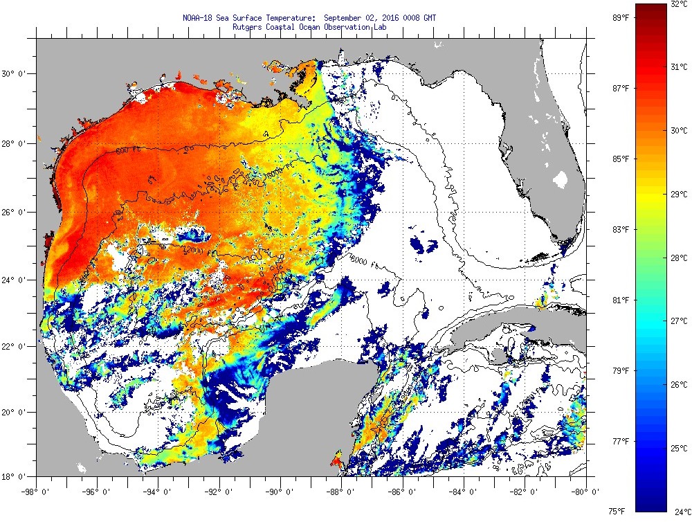
More time in the Gulf would have meant tracking west of course where the warmer SSTs are.
A lot of this data doesn’t matter. Most universities track storms in terms of Geography. Most people get lost on this data.
What is important is the sink hole numbers will drop. The St. John’s River, Peace River and Kissimmee River Basins are healthy again. The Fresh Rain and river input from the John’s and Kissimmee Rivers will have some impact on the Lake Okeechobee and it’s mass of green algae. This also impacts the coral reefs in the long run.
Hurricanes and tropical storms are vital to Florida’s ecology. News casters worry about surge, a power outage and such. They are who they are.
Sincerely,
Paul Pierett
Hermine has been quickly downgraded to a tropical storm. I am sure the likes of Hansen, Mann and McKibben are a bit disappointed.
Latest 8 AM update shows a hook North off NJ with a slowing of Velocity.
Make sense?
http://www.nhc.noaa.gov/refresh/graphics_at4+shtml/213134.shtml?5-daynl#contents
Cyclones in the northern hemisphere have a tendency to veer towards the northeast after passing 30N latitude. For Hermine this tendency is reinforced by a blocking high (anticyclone) heading down from eastern Canada, forcing her away from the coast until Monday, as you can see in this GOES water vapor loop:
http://www.ssd.noaa.gov/goes/east/natl/h5-loop-wv.html
Forecasts beyond that are not as reliable. WU tracking models generally show a northeast heading for the remainder of Hermine:
https://www.wunderground.com/hurricane/atlantic/2016/Tropical-Storm-Hermine?map=ensmodel
and cnn put out the call for anybody anywhere to please send them pics of wreckage and personal devastation – but nothing is coming in.
no pics- didn’t happen.
pure hype.
The map linked in the post has NOAA labeling it a tropical storm, not a hurricane, which would be a filled circle.
It was briefly a hurricane, but the wind speed has now dropped (because it is over land), and is once again a tropical storm.
As this map shows, there was a small area that experienced hurricane force winds
http://www.nhc.noaa.gov/refresh/graphics_at4+shtml/153527.shtml?swath#contents
http://www.nhc.noaa.gov/storm_graphics/AT09/refresh/AL0916S+gif/153527P_sm.gif
>“there was a small area that experienced hurricane force winds”
The map is annotated “From advisories 1 through 21”, so I believe that the red area represents the areas forecasted to have hurricane-force winds, not actually observed or experienced.
AFAIK, there are no surface observations validating these forecasts. The off-shore buoy data would be the most likely candidates, but as pointed out previously in this post, they all show surface winds maxed out around 50mph. Buoy #42036 observed a gust of 75mph when it passed through the eye, but not recorded as a sustained wind speed, necessary to be classified as a hurricane.
At landfall, I saw one WunderMap station reporting 50mph winds. The rest were much lower.
The bottom paragraph, under the graphic.
“This graphic shows how the size of the storm has changed, and the areas potentially affected so far by sustained winds of tropical storm force (in orange) and hurricane force (in red). The display is based on the wind radii contained in the set of Forecast/Advisories indicated at the top of the figure. Users are reminded that the Forecast/Advisory wind radii represent the maximum possible extent of a given wind speed within particular quadrants around the tropical cyclone. As a result, not all locations falling within the orange or red swaths will have experienced sustained tropical storm or hurricane force winds, respectively.”
The NHC graphic is a computer generated guess. They use various inputs to the real time models, aircraft radar, ground radar, etc. But the aircraft are not measuring ground conditions, they extrapolate upper winds down to the surface. Then the NHC puts the inputs into the computer and prints the graphic, with the extrapolated surface conditions. However, the NHC seems to be ignoring the actual surface winds by their own NOAA/NDBC buoys that are in the direct path of the storm. The result is that the NHC is confusing a computer generated model of winds with actual measurements of winds using surface placed anemometers. The actual buoys recorded real winds, and those reorts show one fact. This strom NEVER reached hurricane threshold, either at offshore buoys, or at land stations. The wunderground reports GUSTS, but gusts are not hurricanes. Only sustained winds measured at a certain height above the ground. The NHC should eventually issue a final report on this storm with a real assessment, but the damage is already done. Everyone now thinks the storm made landfall as a hurricane. The real bottom line is that was measured as a 53 knot tropical storm, at a couple buoys and at one land station nearest the point of landfall.
The NHC is responsible for confusing reality with forecasts, and history needs to be reminded that this reliance on computers is becoming more common, and the discrepancy of the models from reality is becoming larger over the years. The clueless media and weather channel don’t care about reality, they just read the “official” NHC advisory and repeat what is says.
Looks like NY may get some of the wrath. And as a result, I predict this will end up being called “Super Storm HERMINE”.
A real borderline case. Measurement / gauge R&R theory would deem this a TC only, not a hurricane.
It’s the first hurricane to hit FL in more than a decade. The US hurricane drought continues, despite the anti-scientific screechings of climastrologist preachers.
If it in fact were a hurricane at landfall.
I was curious about that.
It likely was but I never saw in any of the reports I saw just what category it was or for how long it was an “official” hurricane.
Don’t get me wrong. I almost died in tropical storm Ilya(?) back in the ’70’s. They are bad.
But in the context of CAGW hype and the reliance on computer models, just how bad have things been?
Those who hype CAGW, such as “The Storm Channel”, have been starved for disasters “projected” to happen.
Another thought. TSC has been hyping the weather disturbance for a week or more saying it would become a hurricane.
Someone made a comment on another post that Joe Bastardi said it looked like it would become a hurricane.
The difference?
Joe B said it looked like it would.
TSC hoped it would.
Here is weather underground on this strong rainstorm. Simply having tropical storm winds doesn’t make a tropical storm. In this review of the storm I don’t see any justification for the claim that it ever was a hurricane. Aren’t the winds supposed to be surface winds?
https://www.wunderground.com/news/hurricane-hermine-landfall-florida-georgia-carolinas
That report shows GUSTS, not sustained surface winds. Gusts do not make a hurricane.
People need to learn and understand what a hurricane means, with scientific, methodical definitions so that history can record what actually is happening. Real sustained surface winds NEVER reached hurricane threshold. It’s sad really. The detachment of the media freak show from reality. The tropical cyclone Hermine that made landfall in Florida in 2016 was NOT a hurricane, but almost every fool in the world now seems to believe that it was a hurricane.
Early photos of the actual damage are consistent with tropical storm damage. People have been doing damage assessments from past storms for many years. Insurance companies, engineers and others know what wind damage means and how to minimize costs. It’s a methodical science that looks at and compares damage sustained from photos and examination of known structures, roof shingles, broken windows, downed poles, tree damage, etc etc. to actual winds at various directions and forces. Look at the photos and videos and judge for yourself, yes there is certainly some damage to be expected from tropical storms, and that is what we see in this case.
Fox News is saying Hermine could “regain” [heh] to hurricane strength.
http://www.foxnews.com/us/2016/09/03/forecasters-predict-hermine-will-regain-hurricane-strength-once-it-hits-east-coast.html
Not likely. She is entering waters close to (or below) 26C, which is the “keep alive” threshold for these storms:
http://i65.tinypic.com/219unx1.png
Interesting, how does one update this for latest information
Looks to me that actual data from buoys and land readings, that there were no sustained winds over 74 mph. Gusts were over that, but that’s not the definition of a hurricane. It was a hurricane on computer models, but not with actual data. Looks to me that it was a strong tropical storm which hit Florida. They are now predicting hurricane strength again Sunday out over the Atlantic…
NHC Poor Writing Skills The obviously below average writing skills of professional staff at NHC is deplorable and inexcusable. The 11:00 am Discussion on Sept. 4th is typical. An 8th grade English drop-out could do as well. This is a very negative reflection on NHC’s public image. Pathetic.
I saw a bit of TSC’s coverage this morning.
Stephanie Abrams seemed to be almost apologizing for their forecast. I say “almost” because she seemed to keep reminding the viewers that most of them had a degree in meteorology.
Mr. Layman here.
That makes me wonder if degrees in meteorology have been for some time been given based on the ability to read a computer screen, not an understanding of “weather”.
Computers and their models are TOOLS and tools only.
Valuable tools. But only a tool for one who knows how to use it AND reach an accurate and reliable forecast.
Electricity still out for about 25K in Tallahassee. Within 3.3 miles of state Capitol were out for about 36 hours, and lacked telecomm for about 72 hours. Lots if trees were down, a few on cars, homes. But the line-men and tree crews made a relatively quick job of clearing up much of it. Slept through much of it, then hiked around the neighborhood clearing small debris.