by Hans Erren

With a small majority of 94 over 78, the people of Shishmaref on the barrier island Sarichef in Alaska, voted on August 16th to leave the island. It is yet another voting in long row that all never came into force. The issue that becomes more evident, however, is the ever dwindling majority: on August 11 1973 it was a vote of “everybody”, in July 2002 it was 161-20 and now 94-78 on a population slightly below 600.
The facts
The recent news prompted me to gather some objective US government data to map the erosion of the Alaskan barrier islands between 1950 an 2012. I found a detailed topographic map of 1950, and recent digital elevation data of 2012. The data confirmed again what I had found out already six years ago (in dutch): Sarichef Island is migrating north east, wheras Shishmaref town is eroding on the west side. The island is not disappearing into the sea, the channel on the east side is moving eastwards a well. The easternmost tip of Sarichef Island has now even reached the location of the westernmost tip of the neighbouring island in 1950.

Comparison of the Shishmaref coast in 1950 and 2012


Shaded relief of Sarichef Island Elevation map of Sarichef Island
Moving?
Is it a wise decision to leave the island for the mainland? Two islands in The Netherlands were faced with a similar situation in the past: The town of West-Vlieland in 1734 and the island of Schokland (now a UNESCO world heritage site) in 1859.
Schokland was a peat island in the Zuyderzee that was prone to severe coastal erosion. In the end, the 650 inhabitants were manoevering on narrow wooden boardwalks across the remnant of the island. They were forced to evacuate to the mainland in 1859, were they lived in poverty outside the gates of the rich town of Kampen.
West-Vlieland in many aspects is similar to Shishmaref. This town also was located on a barrier island and it also eroded on the western side. Even the town plan of 1720 of West-Vlieland shows some similarities with current Shishmaref. However, in contrast with the people of Schokland, the West-Vlieland people stayed on their island, they just relocated eastwards to the town of Oost-Vlieland. On the eastern side of Sarichef there is still (even more!) room to relocate, and a growing part is willing to stay, because they know that on the mainland only poverty awaits, just like the people of Schokland in 1859. Island erosion is clearly a phenomenon of all times, and cannot specifically be blamed on humans.


West-Vlieland in 1720 Shishmaref in 2016
The future
Sarichef is the most famous island of Alaska, it has an airstrip, but no hotel. One would imagine, that after the island became “hot” in 2009, that the islanders would have seized this golden opportunity to welcome interested and concerned eco-tourists, there is also plenty if wildlife to spot in these pristine wetlands. The Dutch counterpart Vlieland is a very popular destination for tourists who look for a quiet nature experience with seals and bird life.
In short: there definitely is a golden future ahead for Shishmaref. Which enterpreneur will fund the construction of an eco-hotel on the island? Then the paying guests can arrive! A status as UNESCO world heritage site would boost the status of the island even more, that same status brings people back to Schokland in The Netherlands.
References:
* Dermot Cole, Shishmaref’s split vote on whether to go or stay erodes its position, Alaska Dispatch News,26-8-2016
* Michael Bastasch, Beyond The Spin: Alaska Village’s Demise Is More Complicated Than Yelling ‘Global Warming’, Daily Caller, 21/8/2016
Data:
Topo maps 1950 https://www.topoquest.com
* Shishmaref B-3, download geotif
* Shishmaref A-3, download geotif
Elevation data 2012 http://ifsar.gina.alaska.edu
John Davies add via email:
John Davies
During a recent conversation about global warming (when I stated that actual sea level rise was a tiny % of that claimed by politicians & the MSM ), someone came up with the slightly sarcastic comment –
“Anything to bolster a belief that the Inupiat villagers of Shishmaref in Alaska will be able to move back onto their land-bridge homestead ”.
Well, we’ve all seen dramatic headlines like –
“Climate Change Takes A Village”
http://www.huffingtonpost.com/2014/12/14/shishmaref-alaska-climate-change-relocation_n_6296516.html
“Alaskan village threatened by rising sea levels”
– complete with spectacular photos of buildings falling into the sea…. to prove it’s all true !

http://img.huffingtonpost.com/asset/crop_0_80_2750_1609/57b4f36e170000ae02c73e10.jpeg
And if you Google Shishmaref you get – About 513,000 results (0.57 seconds) – a lot are of a similar nature – & no I haven’t checked them all.
So, I had a quick look at Shishmaref village & the island of Sarichef.
Where is it
66°15’20”N 166°04’20”W – http://tinyurl.com/hegfhcg near the Bering Strait, Alaska.
It’s a 7.2 km2 barrier island protecting the Shishmaref lagoon situated on the North West side of the Seward Peninsular; 124 miles north of Nome, & five miles from the mainland. It faces the Chukchi Sea.
Historical Background
It was excavated by archaeologists around 1821. This showed Eskimo habitation for several centuries, probably as a summer camp for the semi-nomadic Inupiat population.
Around 1900, Shishmaref’s excellent harbor had become a supply center for gold mining activities to the south.
The village was named after the inlet, and a post office was established there in 1901.
“Early in the 20th century the U.S. government pursued a deliberate policy of ending all nomadic lifestyles among Native Americans. The people of Shishmaref weren’t forcibly collectivized in the way that Natives were elsewhere in the country in the 19th century, but the government’s opening of a school in Shishmaref, coupled with the onset of compulsory education, had the same effect.
For the traditionally mobile Inupiat who settled there, Shishmaref made a certain amount of sense. It’s ideally located for winter hunting on sea ice and close enough to the mainland to access traditional subsistence grounds in summer. It was, however, always tenuous ground to build on.”
From ‘Fierce Climate Sacred Ground’ – By Elizabeth Marino 2015.
In 1969, the city government was incorporated.
The 2015 population ~560.
In 2002 & again on 16/8/2016, the village voted to move the town to the mainland.
The geology of Sarichef Island (http://alaska.guide/Small-Island/1409092/Sarichef-Island )
The island consists mainly of gravel banks & sand dunes.
Tidal flows & prevailing winds produce ‘Longshore drift’.
It’s part of a dynamic, 100km-long barrier island chain that’s constantly moving.
(similar to the UKs – Spurn point, Orford Ness, Chesel bank, Blakeney point, Fairbourne , Dungeness, our own Newborough warren & numerous other sites around the world)
Some useful pics & diagrams of the area here –
http://climategate.nl/2009/02/08/the-last-days-of-shishmaref-not-likely/
I found this book interesting: ‘Pitfalls of Shoreline Stabilization’ Cooper & Pilkey. http://tinyurl.com/zqjm9b2 (scroll down for text)
– Particularly the part that mentions Shishmaref.
• 5.3.1 Storm History. Including ‘total inundation in 1893’;
• Table 5.1 ‘in 1996 badly designed Barriers actually contributing to erosion’;
• 5.6 The Uses & Abuses of Anecdotal Accounts. (an example off how to sell a story)
• 5.6 Studies by ACE (Army Corps of Engineering) & CU (Colorado University) of erosion rates from 1937 to 2003 using Maps, Aerial photos & on the ground measurements, show erosion was highest in the 1940s declining until the 70s when it spiked again.
Shore front Erosion losses = In total 77m lost over 76years (long term average = ~1m/yr) but there are spikes (at approx 30yrs )-1940s ~26m; 1970s ~13m; 2000s ~8m, showing a diminishing trend.
“Shishmaref island exhibits an erosion rate nearly twice that of non-developed shorelines.” (Manley et al 2007).
[ Preliminary calculations are that erosion rates average 1m per year, contrary to the anecdotal accounts of >10m per year reported by news agencies since 1997 (Lempinen 2006). The average rate is twice the rate on undeveloped adjacent islands. Erosion has accelerated around the margins of the revetments, expanded from cement blocks and gabions in the 1980s to boulders placed since 2001. ]
• 5.7 “Despite the warmer limited sea ice of the past several years, Shishmaref has NOT reported heightened erosion, even during the ‘Great storm of 2011’.
Sea level rise
Arctic Circle Region
http://tidesandcurrents.noaa.gov/sltrends/arctictrends.htm
Sea level rise Shishmaref <0.3mm/yr.
“These new data points supplement the curve produced from the Shishmaref barrier island, lagoonal and deltaic marsh peats which indicate the cumulative averaged rate of sea level rise in the Chukchi Sea was very slow, 0.27 mm year”
See pg 20 – Minimal late Holocene sea level rise in the Chukchi Sea. Pdf http://tinyurl.com/hetobwc
Conclusions
1. Longshore drift & prevailing winds are the main cause of the erosion & re- formation. (Attrition & Accretion)
2. Annual erosion levels have been falling since 1940s.
3. Erosion rate appears to accelerate then subside every ~30 years.
4. Erosion was increased by human interference of a natural process.
5. Over a century of constant habitation, has proved that putting ‘permanent structures’ in a fragile & moving landscape is prone to fail (like building on floodplains, or on the side of an active volcano).
The original nomads got it right – Use it as a summer camp & move away in winter.
6. Nature will eventually completely remove the island & rebuild elsewhere….Again & Again….in its own timescale. It won’t take account of mans hopes or desires (however important we think we are); because that’s how nature works!
Our ancestors learned that….but it’s a lesson we seem to have forgotten.
7. Sea level rise at less than 0.3mm/yr is not a major issue.
8. A dynamic barrier island, gravel banks, sand dunes, storm surges, permanent structures collapsing;
(there may be some clues somewhere in those words ! )
But for those of a religious disposition, see Matthew 7:24-27
9. It is a man made disaster (for man), but involving mainly Geology…not Climate.
The answer to the opening comment is –
The villagers will have to move from their historically government enforced settlement & maybe return to the ancestral nomadic existence, albeit with 4x4s, smart phones & satnav.
The world has a long history of settlements (built in the wrong place) being lost to the elements, I could list 100s (& if you’re not careful…. I will).
The inhabitants of Shishmaref are victims of a modern bureaucracy, not global warming…. IMHO.
Refs & further reading –
• http://alaska.guide/Small-Island/1409092/Sarichef-Island
• ‘Fierce Climate Sacred Ground’ – By Elizabeth Marino 2015
http://www.adn.com/books/article/more-global-warming-afflicts-endangered-shishmaref/2016/03/27/
• ‘Developments in sedimentology’ John Allen 1984
• Minimal late Holocene sea level rise in the Chukchi Sea:
Arctic insensitivity to global change? Mason & Jordan 2002 PDF – http://tinyurl.com/hetobwc
• http://tidesandcurrents.noaa.gov/sltrends/arctictrends.htm
• ‘Pitfalls of Shoreline Stabilization’ Cooper & Pilkey. http://tinyurl.com/zqjm9b2
[- it’s available from Amazon https://www.amazon.co.uk/s/ref=nb_sb_noss?url=search-alias%3Daps&field-keywords=Pitfalls+of+Shoreline+Stabilization
for – £90 to £321. Ebook £43….How much !!! ]
• http://climategate.nl/2009/02/08/the-last-days-of-shishmaref-not-likely/
• Longshore drift explanation – http://www.alevelgeography.com/transportation/
http://www.geography-site.co.uk/pages/physical/coastal/longshore.html
• & wikipedia; Sorry !! – https://en.wikipedia.org/wiki/Shishmaref,_Alaska
The outer banks and barrier islands of North Carolina have been migrating, appearing and disappearing for centuries. Many a beach house has gone into the sea in my lifetime. It happens.
A little history of North Carolina’s barrier islands. Bodie Island lighthouse was built next to the ocean and on its own island. It was separated from what is now Nags Head. This inlet was what Walter Raleigh used to find Roanoke Island and start the first British colony. Now it is 3/4 mile from the oceanfront and connected to the barrier island north of it.
Just to the south is Oregon Inlet. So named because a strong hurricane ripped apart the island and the first ship to discover it was named Oregon. There is a Coast Guard station on the back side of the inlet that, when I was a kid, was adjacent to the water. Now it is about 600 feet from the water, and getting further away.
Crossing over Oregon Inlet is Bonner Bridge. This is one of the worst bridges in America. The state has been wanting to replace it for over a decade with a bridge designed around the understanding of how the barrier islands work. But the eco-idiots kept suing the state to prevent this, wasting both time and money. Finally, a “settlement” allowed the state to proceed with the original plan.
Oregon Inlet is, naturally, filling in. But the state keeps dredging it because if they didn’t, boats would have to travel hundreds of miles out of the way to access the ocean. Even still, the area is too dangerous for large shipping boats.
If you keep going south, you finally get to Cape Hatteras. This is where the Gulf Stream current makes it turn toward Britain. Hatteras light is a historic lighthouse that was in danger of falling into the ocean, so the National Park Service moved the entire lighthouse in an amazing engineering feat. When I was a kid, I remember how close the lighthouse was to the ocean. Where the light once stood is now part of the ocean, albeit barely.
Going much further south there is Cape Lookout. Once when I was young, my dad took our family in his boat to Cape Lookout. At the time, it was owned by the Coast Guard. We spent the night in the shadow of Cape Lookout. Several years later, we returned and I was amazed at how much had moved. Being young, I didn’t know about the shifting sands. Cape Lookout is on the back side of a barrier island and even there, the sands are constantly shifting.
Blackbeard the pirate loved the area because he knew the shoals best. Crooks would tie lanterns around an old nag’s (donkey) neck and march them down the beach at night. Ships would think it was a distant lighthouse and run aground where the locals would plunder the ship. Ergo, the town name Nag’s Head. People have called these barrier islands the ‘Graveyard of the Atlantic’ because the islands shift so much. Change is a fact of life on these islands. Anybody who thinks climate change is responsible for sinking barrier islands is either ignorant or an alarmist.
Excellent summary, thank you. The people of Happisburgh (“Hazebro”) on our East Coast saved their lighthouse from decommissioning by Triniy House. WUWT dealt with a FoE scare story about erosion there in December 2014. The traditional riposte to nonsense like this was “Tenterden steeple was the cause of Goodwin Sands”. Brewer’s Dictionary has more about the silting up of Sandwich and the Goodwin Sands.
http://www.bartleby.com/81/16343.html
The Romans used to go from Sandwich to Reculver in their galleys through the Wantsum Channel between the mainland and the Isle of Thanet, saving themselves a rough sea journey. The Vikings used it to raid Canterbury. It’s all dry land now of course.
Apologies to the ‘Holy and Undivided Trinity’ for the typo. My excuse for recommenting is this chart of 1548 from British Museum (south at top).
http://www.bl.uk/onlinegallery/onlineex/unvbrit/a/001cotaugi00001u00054000.html
That means, it is a natural phenomenon that change the shape of islands over a period of time and this has nothing to do with global warming as often claimed by the group of warmists. Coastal erosion and island erosion are common. The impact will be more felt with human destruction activities.
Dr. S. Jeevananda Reddy
Never mind we will fix it with one of these
http://i.dailymail.co.uk/i/pix/2016/08/28/18/37A82F6100000578-0-image-m-8_1472403656005.jpg
http://www.dailymail.co.uk/news/article-3762477/Massive-wind-turbine-catches-fire-burns-hours-German-fire-fighters-don-t-ladders-long-tackle-100m-high-blaze.html
Barrier islands are not called “ephemeral” for no reason.
When the same story was in the media more than 10 years ago I soon found a study about this from US Army engineer corps from around the 1950-60s they concluded that the area is naturally eroding and that the real problem is Marxism pushing their agenda.
Barrier Islands move. They always have. And they always will.
They wouldn’t if you really cared.
Can’t stop nature…
I hope that was sarcasm.
Ahead, sarc factor 6, Mr. Chekov.
Droll! 😉
Aren’t there (uninhabited) islands in Chesapeake Bay that move to the point of vanishing?
Grog Island at the point of Indian Creek and Dymer Creek has disappeared near Windmill Point. Isabel was the start of it all with salt water over-washing it first killing the root systems of the pine trees, then the nor’easter’s finished it off over the next few years.
Absolutely nothing left now but a sand bar and great memories of anchoring out with a groups of boats over the years. There was deep water on the SW side where you could snug up to shore and enjoy the breezes coming off the Bay in the summer without the swells. You could swim in the luminescent waters in the late summer after the nettles were gone (with or without attire).
Yes indeed. Inhabited ones too like Sharp’s Island (now a shoal) or Smith Island (still inhabited by about 450 people who one hopes are good swimmers) and several others. Tangier Island (population about 700) is becoming smaller by the year and if left to itself will disappear in a century or two. However a move is afoot to build seawalls at great public expense to try to delay the inevitable. The inevitable being subsidence affecting pretty much the whole bay and isostatic rebound from the last ice age – which ended due to global warming. Ground water depletion causing further subsidence has also been a factor on some islands. Naturally all of this and the accompanying “loss of a way of life” is blamed on ‘climate change’ ignoring the facts that these effects have been going on since long before Virginia was founded.
Additionally, consider all the shifting islands, bars, and channels in the Mississippi river system. The river wandered as it pleased until the end of the 19th century when channelization began. Still, many states hold territory on the other side of the river due to course changes. Every time a river wants to change it’s somehow considered wrong and efforts are made to put it back into place.
I remember Tangier Island, was there for four (4) days in the winter of 1975 (I think it was) when on a Chesapeake Bay “duck hunting” trip. No ducks to shoot at but sure enjoyed those Chesapeake Bay oysters, both fried and raw (on the half-shell).
My favorite example remains Hog Island off New York : https://en.wikipedia.org/wiki/Hog_Island_(New_York) .
Didn’t Willis already go over this Alaska barrier island village in an article several years ago? I think this is old news.
Breaking News! Seventh First Climate Refugees Discovered
Well, my heart fell when I saw the recent BBC article which proudly proclaimed that the people of Kivalina were slated to become “America’s first climate change refugees” …
https://wattsupwiththat.com/2013/08/09/breaking-news-seventh-first-climate-refugees-discovered/
The Sixth First Climate Refugees
https://wattsupwiththat.com/2013/07/02/the-sixth-first-climate-refugees/
Indeed it is old news, but the inhabitants of Shishmaref voted on 16 august again to leave. And the detailed elevation data is now availabke for Alaska, that’s why I wrote this post.
Great post Hans. Thanks for mentioning the vote in ’73 where “everybody” voted to leave. Maybe the “news” should have been, “Shismaref losing interest in moving”. I look forward to the next vote.
I didn’t mean to criticize your article. Sorry if it came off that way. It is important to update this information with new data, especially when headlines are again blaming “climate change”. Thanks for doing that, and providing some real data which the other news organizations don’t point out or even get into. I was just looking for the Willis article and couldn’t find it…JPP
Uh…no. Why read obvious dishonest propaganda articles in those rags?
I’d rather watch paint dry. Even most Americans are now vividly seeing for themselves the final destruction of any last semblence of honest jounalism at the NYT, CNN,and CBS.
When it takes an organization like Judicial Watch to use FOIA and the courts to uncover the Clinton Crime Syndicate graft machinations and other Obama Admin dishonesty, and the FBI director cowers in the face of Clintonian intimidation, where it used to be mainstream investigative journalism like 60 Minutes and the WaPo, you know our Republic is in deep trouble from the Socialists’ assault on liberty.
Yep, don’t want to give huffypo any credit my my click there.
Hallo Hans
er is geen mens gemaakte verwarming
dat wist ik al\
er is geen ruimte voor dat in mijn vergelijking?
alles is natuurlijk en je in de natuur moet je gewoon kiezen, wat het BESTE is…
Quick translation:
Clear evidence that barrier islands do what barrier islands do: move. I’ve had many an argument with fools who also believe that due to sea level rise places like southern Louisiana and Miami Beach are being inundated, and ignore clear evidence of subsidence from groundwater withdrawal and human-induced interruption of the natural rebuilding processes of annual flooding. Man is highly arrogant, and climate alarmists are even more so. Nevertheless, nature is going to do what nature has and always will do, and we need to remember that we cannot control it.
Wise Indian said “Put teepee next to water, brave get wet”.
“Happy granting ground”
At some point Government will get involved, for the children, of course.
Sounds like they were already involved – and yes, they used the children’s education as a whip to control the native population’s culture.
Global Warming is to blame because, as everyone knows, barrier islands had been static since the earth cooled — and right up until evil man lit his first smoke.

…then all hell broke loose!
Geez America.. Settle down!
Would it hurt to do some cleanup burns before summer, or does that happen every year? I’ll bet Obummer’s holding back the fire trucks again.
Note that ‘merica’s the only country on fire. selfish prigs. Rest of the world doesn’t exist according to your education system.. 😉
Shortly WE won’t exist (historically) in our own education system
http://freebeacon.com/culture/top-ranked-colleges-dont-require-history-majors-study-u-s-history/
Ancient city of Heracleion was lost to the sea 1,200 years ago.
“Several natural phenomenon caused these cities to sink by a maximum of (32 feet) below the sea,” Masson-Berghoff says, noting that a naturally rising sea level, subsidence and earthquakes (which ultimately triggered tidal waves) all played a hand.”
http://wtvr.com/2016/05/07/the-secrets-of-a-lost-egyptian-city-were-underwater/
Dwarka, India, as well. Well-studied underwater archaeology.
The obvious cause of barrier island disappearance aside, as I understand it, there are two theories for the existence of water on the face of the planet.
Extraterrestrial, in the form of comets and asteroids..and water forming deep within the planet rising to the top (I suppose).
Sea level continues to rise at an insignificant rate.
Are the two mechanisms noted suddenly not in play anymore for some reason?
Just askin’.
OT but I’ve been following the Northabout Polar Ocean Arctic expedition and they’ve been giving water and air temps on the journey. They are currently just off Barrow and report ocean temp at .3C which is 32.54F yet SST anomalies from Unisys, NOAA, nullshcool, etc…. are showing the water well above normal. If it was a few degrees cooler it would be ice! Something is not looking right.
Gonzo
It depends at what depth the temperature readings were taken as there is often a temperature gradient just below the surface which can make a considerable difference depending at what depth you sample it at.
The global SST records to 1850 for example had buckets thrown over the side to varying depths and no consistency in their subsequent reading( except on scientific expeditions like Challenger) global records became more consistent and accurate around the 1950’s or so.
It may be that the Readings taken by the ship and such as NOAA are not on a like for like basis
Tonyb
I believe they’re satellite data which you would think are surface data. I would also think the Northabout readings are surface as well. Also here Southern California they show ocean temps above normal but about 2weeks ago there was an upwelling and water temps dropped several degrees to 65-67F which is below normal.
climate,
I strongly agree.
Sea Surface Temperatures – which is what the number obtained was entered in to when completing the 6 hourly Met. observation – were, until certainly the 1980s, in my personal knowledge, read from a thermometer stuck into a ‘sea temperature bucket’ [about4-5 inches diameter, 16 inches [say 40 cm] deep] that had been thrown into the water, left for two minutes, then recovered – and the thermometer put in, left for about 30 seconds [IIRC], and read to the nearest 0.1 C. Ish.
Probably read to about 0.1-2 C, realistically
Least bad method available, I suppose.
Auto, remembering back in the day . . . . .
Auto
I wrote an article on that very subject some five years ago
https://judithcurry.com/2011/06/27/unknown-and-uncertain-sea-surface-temperatures/
I subsequently carried out some of my own experiments. Depending on where the water was sampled, it’s depth, the original location of the thermometer ( cool cabin or hanging on a hook on deck etc) how long the water was left in the bucket etc etc, made a difference of many degrees.
As ristvan mentions under, it seems very doubtful that the ships reading and that of NOAA are compatible
Tonyb
If Northabout is anything like my former 36 foot sloop ( and I had the same brand marine electronics she has, for a good reason) then her water temp sensor is colocated with the water speed sensor forward on the keel aft of the entry, I would guess maybe less than half a meter below the surface.
http://www.kroooz-cams.com/serenity/serenity3.php
For some reason this reminds me of building on permafrost.
Has anyone considered building on pontoons? When your side of the island erodes, just drag your house around to the other side. Even if the island is inundated, you stand a fighting chance. When I was a kid, people built pontoon boats using recycled barrels. They were pretty cheap. A quick google didn’t find anyone who had tried this as a solution to island erosion.
Fine Homebuilding Magazine has, over the years, devoted issues to analyzing the results of natural disasters … hurricanes, wildfires, earthquakes. The lesson is that it is possible to build for any set of conditions and it doesn’t cost that much more to do so.
That’s an interesting idea because what a lot of those communities have is empty fuel barrels. It’s not economically feasible to send the empties back to be refilled. Or at least it didn’t use to be.
That’s viable in inland waters where the lack of large waves means houseboats can easily cope, but near open ocean.. ouch.
Similar cases of beach erosion can be found all over the world. So what makes this the poster child for Sea level hype? Perhaps because it is in the Arctic. Some sort of weird Arctic=threatened vibe is in action I suspect.
The most important feature of such islands is left out by both sides of the “issue”. Like river deltas and coral islands, sea level rise is of no consequence. These features have a built in mechanism to deal with sea level rise. When sea level rises, deltas and coral islands both grow upwards. Any flooding of a delta moves the “quiet” water farther upstream which the the river responds to by dropping its sediment “earlier”, thus filling in the flooding (both effects are simultaneous). Coral accomplishes the task by simply growing upwards into the rising waters. Even 120m rise in sea level in 12,000 years has been a piece of cake for these two mechanisms. Similarly, barrier islands are built of sand and gravel brought down by rivers and shaped by longshore currents. All three features can change shape, shrink in a storm and be rebuilt in quieter weather, maybe just not in exactly the same outlines. Sea level rise that we have so far experienced has had no effect.
Several earlier generations knew this. It is amazing to me that “earth scientists” of the last generation or two don’t appear to know it. Before the Great Dumbing Down of education by the left, the simple mechanisms described above were readily understood with a little thought by non earth scientists.
Interesting the two writers give broadly similar causes, (natural but no increased climate signature) but both suggest totally different outcomes –
Hans Erren is optimistic & sees a business opportunity:
John Davies is pessimistic & forecasts abandonment:
I suspect both scenarios will cost $$$millions.
Realistically if it’s politically expedient, lots will be promised, little will materialise.
If you live on the most famous island of Alaska and there are lots of tourists willing to voluntarily spend a lot of money on the island, yet there is no hotel?
I do not understand the basis for your calling this “the most famous island of Alaska.” I do not recall ever hearing about it until I saw your article. It may be “famous” in some quarters, but surely other islands are more “famous” for various reasons. As a simple test, I plugged Shishmaref into Google and got about half a million hits. Then I plugged Attu into Google and got a bit over 2 million hits, four times as many. St. Lawrence Island returned four million hits. Just saying…
Basil
Well perhaps not the most famous island of Alaska,mbut the island is the most prominent in the news, I admit I could be a bit biased because of my climate interests and because a dutch movie maker made “The last days of Shishmaref” in 2008.
But oh….it fits the narrative so well!
To add a little more about what someone else said about OBX.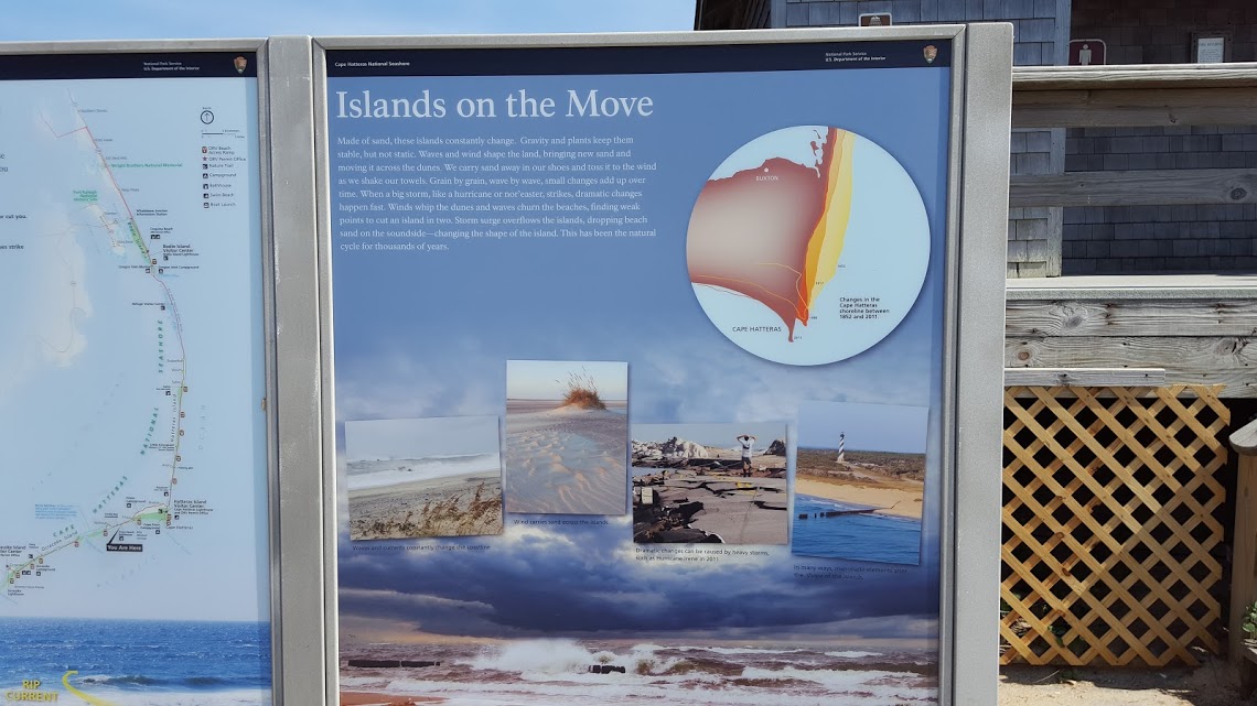
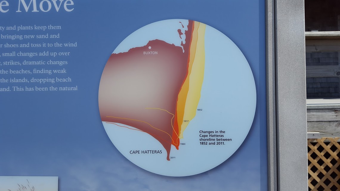

I took these pictures this summer on our vacation there:
“This has been the NATURAL cycle for thousands of years.”
Can we get that tattooed on ALGORE’s forehead?
+1
I’ll believe there is a real problem with sea levels when the Al Gores, David Suzukis and Leo di Caprios sell their ocean-front property.
Area of Hungary, the country I live in, is decreasing annually by a tennis court or two, because Africa is relentlessly pushing Italy towards us. In a hundred million years the entire country will have gone, wedged under Transylvania completely.
I do blame * change for this sad state of affairs and demand, first of all, ample reparations.