Guest Post By Willis Eschenbach
Often I start off by looking at one thing, and I wind up getting side-tractored merrily down some indistinct overgrown jungle path. I was thinking about the difference in the strength of the sunshine between the apogee aphelion, which is when the Earth is furthest from the sun in July, and the perigee perihelion in January, when the Earth and the sun are nearest. On a global 24/7 average value, there is a peak-to-peak aphelion to perihelion swing of about twenty-two watts per square metre (22 W/m2). I note in passing that this is the same change in downwelling radiation that we’d theoretically get if starting in July the CO2 concentration went from its current level of 400 ppmv up to the dizzying heights of 24,700 ppmv by January, and then went back down again to 400 ppmv by the following July … but I digress.
Now, because the Earth and sun are nearest in January when the southern hemisphere is tilted towards the sun, there is a larger swing in the solar strength in the southern hemisphere than in the northern.
While I was investigating this, I got to looking at the corresponding swings of the ocean surface temperature. I split them up by hemisphere, and I noticed a most curious thing. Here’s the graph of the annual cycle of solar input and sea surface temperature for the two hemispheres:

Figure 1. Scatterplot, top-of-atmosphere (TOA) solar input anomaly versus ocean surface temperature. Northern hemisphere shown in violet, southern hemisphere shown in blue. Monthly data has been splined with a cubic spline. Data from the CERES satellite dataset.
So … what is the oddity? The oddity is that although the swings in incoming solar energy are significantly larger in the southern hemisphere, the swings in ocean temperature are larger in the northern hemisphere. Why should that be?
The difference is impressive. As a raw measure, the northern hemisphere ocean surface temperature changes about seven degrees C from peak to peak, and the TOA solar varies by 216 W/m2 peak to peak. This gives a change of 0.032°C per W/m2 change in solar input.
In the southern hemisphere, on the other hand, the ocean surface temperature only swings 4.7°C, while the solar input varies by 287 W/m2 peak to peak. This gives a change of .0162°C per W/m2, about half the change of the northern hemisphere.
So that’s today’s puzzle—why should the ocean in the northern hemisphere warm twice as much as the southern hemisphere ocean for a given change in solar forcing?
Part of the answer may lie in the depth of the ocean’s mixed layer. This is the layer at the top of the ocean that is mixed regularly by a combination of wind, waves, currents, tides, and nocturnal overturning. As a result, in any given location the mixed layer all has about the same annual average temperature. (However, monthly changes are still largest and the surface and decrease with increasing depth.) This mixed layer worldwide averages about 60 metres in depth. But the mixed layer is deeper in the southern hemisphere, averaging about 68 metres in the southern hemisphere versus about 47 metres in the northern.
However, two things argue against that conclusion. One is that the mixed layer in the southern hemisphere is about 45% deeper than in the northern … but the northern hemisphere sensitivity of temperature to incoming solar is double, not 40% larger.
The other thing that argues against the mixed layer difference is that the thermal lags in the two hemispheres are very similar, with peak temperatures in each hemisphere occurring almost exactly two months after peak solar. In a previous post entitled “Lags and Leads” I discussed how we can use the difference in time between the peaks of solar power and temperature shown in the scatterplot in Figure 1 to calculate the time constant “tau” of the system. This two month lag is equivalent to a time constant tau in both hemispheres of 3.3 months.
Then, using that time constant tau we can calculate the equivalent depth of seawater needed to create a thermal lag of that duration. A time constant tau of 3.3 months works out to be equivalent to 25 metres of seawater with all parts equally and fully involved in the monthly temperature changes (or a deeper mixed layer with monthly temperature swings decreasing with depth).
But since the time constant “tau” is the same for both hemispheres, this means that the equivalent depth of water that is actually involved in the annual cycle is the same in both hemispheres.
Or in other words, the more of the ocean that is involved in monthly temperature swings, the greater the lag there will be between solar and temperature peaks. But in this case, the thermal lags are the same in both hemispheres, meaning the equivalent depth of ocean involved is the same.
Then, I thought “Well, maybe it’s because one pole is underwater and the other pole is on land”. So I repeated the calculation of the temperature and solar swings using just the range from 60° North to 60° South, in order to eliminate the effect of the poles and the ice … no difference. The northern hemisphere non-polar ocean warms twice as much for a given change in solar energy as does the southern non-polar ocean. The difference is not at the poles.
So my question remains … why is the northern hemisphere ocean surface temperature twice as sensitive to a change in solar input as is the southern hemisphere ocean temperature?
My best to all. Here, we have had a rare June rain, most welcome in this dry land, so for all of you today, I wish you the weather of your choosing in the fields of your dreams …
w.
My Usual Request: Misunderstandings can be minimized by specificity. If you disagree with me or anyone, please quote the exact words you disagree with, so we can all understand the exact nature of your objections. I can defend my own words. I cannot defend someone else’s interpretation of some unidentified words of mine.
My Other Request: If you believe that e.g. I’m using the wrong method or the wrong dataset, please educate me and others by demonstrating the proper use of the right method or the right dataset. Simply claiming I’m wrong about methods or data doesn’t advance the discussion unless you can point us to the right way to do it.
UPDATE: Here are two maps of the same data, which is the change in ocean temperature per 0ne watt/metre squared (W/m2) change in top of atmosphere (TOA) solar radiation …


The gray contour lines show the global average value of 0.02 °C per W/m2.
There are five more days included in the vernal equinox to the autumnal equinox time span as compared to the autumnal equinox – vernal equinox time span. Maybe this accounts for something.
Good point! Would it make a difference if it were 50 days?
Also, if the increased intensity of the sun in the Southern Hemisphere causes earlier thunderstorms than the lessened solar intensity in the Northern Hemisphere (something that was noted by Willis several months ago) then the added five days of sunlight coupled with the lessened cooling effect of thunderstorms could possibly have a noticeable accumulative effect.
Maybe; Just throwing this out as something to look at.
If the amount of time and the amount of intensity that went into heating up a body of water made no difference then the body of water would heat up to same temperature no matter what the time or the intensity as long as the total energy that went into the body of water remained the same.
But when the intensity causes such energy releasing phenomena such as thunderstorms to occur then the degree of intensity and the time of this intensity would make a difference.
Lessened solar intensity and lengthened time should decrease the energy lost due to thunderstorms in the Northern Hemisphere as compared to the decreased amount of time and increased solar intensity in the Southern Hemisphere.
Marv said:
Right you are, Marv, …… but the fact is, …… the question involves two (2) different bodies of water, to wit:
Willis Eschenbach said:
Well now, the logical answer to the above question is:
It requires less thermal energy, or Solar energy in this case, to warm-up the water in a small pot (NH) than it does to warm-up the water in a larger pot (SH).
Or, to be more specific to the questioned asked:
If the same intensity of Solar energy is applied for the same amount of time ……. to both a small pot (NH) and a larger pot (SH) of water, …… the water in the smaller pot (NH) will attain a higher temperature than the water in the larger pot (SH).
And the following graphic defines the relative sizes of the two (2) pots (hemispheres) in question:
http://theworldsoceans.com/oceans.jpg
Okay, I’m going to give it another try to get my point across:
If thunderstorms are formed as a result of the intensity of sunlight hitting the ocean’s surface and these thunderstorms act to transfer heat from the ocean’s surface to several miles upward AND if the clouds from these thunderstorms act to block sunlight from hitting the ocean’s surface then it follows that the more thunderstorms that are formed over the ocean the less will be the resultant heating up of the ocean’s waters.
If the intensity of the sunlight increases then the number of thunderstorms, the intensity of the thunderstorms AND (and possibly the most importantly) the timing of the thunderstorms will be altered, meaning the thunderstorms will begin to form early in the day. Plus the increased intensity will cause the ‘swath’ – the width – of the thunderstorm band to be increased over the ocean’s surface. Add to this the diminished amount of sunlight days in the Southern Hemisphere as compared to the Northern Hemisphere and you will end up with a significant edge in Northern Hemisphere ocean warming as compared to Southern Hemisphere warming.
My guess is that the relative percentages of land in the NH vs SH might be important.
With more land in NH, there is less water (?) for the sun hitting the water to warm (or to let cool). However, all that extra land still gets heated, and as rain falls on the land it gets heated (or not in winter). As the rain gets drained into the oceans, the extra heat affects the ocean max & min temperatures.
Part of the extra delay in the NH may be due to the snow which doesn’t flow down to the sea until it melts first.
Samuel C Cogar,


That would be true iff the same amount of energy were involved. Unfortunately it isn’t. He was writing about a number of watts per square meter being the same, which is fine except it is integrated over the surface area, meaning that the northern hemisphere receives less energy than the south, but heats far more.
The reasoning for the above goes something like this:
Which (if the latex shows up) leads to a surface area term in the numerator and denominator making total energy unimportant.
The better analogy on your pots is two pots of the same heights but differing surface area each sitting on a burner that puts out the same amount of energy per unit area. The two pots will heat at exactly the same rate. Of course that is part of the conundrum here, since the data says they obviously do not heat at the same rate. This begs the question of is there more cloudiness in the southern hemisphere? It would not take much difference in cloud surface area to throw the equivalences off.
In short I don’t have the answer either, but I don’t think it has to do with the surface area. Perhaps it has to do with the effects of the northern hemisphere currents pumping the same volume of water pole-ward where it is mixed with a much smaller volume of northern hemisphere surface water? We can’t let ourselves fall into the same trap as the climate crowd and blame everything on radiation and forget about convection and conduction. The ocean is a pretty complex environment.
@ Owen in GA
Now that was a fine response ……… so maybe you can answer another question for me.
Let’s say that you were really, really hungry …. and needed something to eat pretty quickly ….. and decided to fix yourself a single-serving of noodles, ……. would you put a five (5) gallon container of water on your stove burner to bring to a “boil” (212 F) before you put the noodles in for cooking …… or ……. would you put a one (1) quart container of water on your stove burner to bring to a “boil” (212 F) before you put the noodles in for cooking?
Owen in GA, which one (1) of those two (2) pots of “noodle-cooking-water” will begin to “boil” (212 F) in the least amount of time?
And please explain your answer to edumacate me on this subject.
And ps, Owen in GA, iffen you have ever been in the North country (New York/Minnesota) in the Springtime you would surely notice that a small lake receives the …… “same number of watts of Solar irradiance per square meter of surface area” …… as does a large lake ……. but, due to the H2O temperature difference, one can go “skinnydipping” in the small lake a couple of weeks earlier than they can in the larger lake.
Small swimming pools, farm ponds and lakes “warm-up” the quickest come Springtime.
And the inflow of river water, the THC and the Gulf Stream helps the Atlantic Ocean “warm-up” come Springtime.
[Note that “shallow water” vs. “deep water” is more important than “large lake” or “small” lake. .mod]
Samuel C Cogar,

 ) SA is surface area, d is depth,
  is density and Q is heat energy.
 gets wonky.
Lived for a big part of my growing in those northern parts (though somewhat south of your examples – in Illinois). The farm pond was usually about 6 or 7 feet deep while the lake down the way was nearly impossible to find the bottom when diving. (I was 8 or 9 when I tried to find the bottom so it was probably only 20 or 30 feet deep. One of the ponds was spring fed so it tended to stay unfrozen except for the worst part of January or February. I would not have liked to swim in it from October on to May – never got the fascination with those “polar bear clubs”.) The lake is a much larger mass of water to heat up in the water column. In my experience, melting on most of the ponds was more a function of air temperature and rainfall than sunlight. In the example of the two pots we have a fat pot that is very deep versus a small pot that is very shallow.
As to the pot configuration for some quick noodles – provided the burners were able to provide heat across the bottom of each, I would put 3 or 4 inches of water in the bottom of the 5 gallon pot rather than fill up the quart pot. They would each have a quart or two of water, but because of the much larger surface area contacting the burner, the larger pot would boil much more rapidly. I would be eating noodles while the quart pot was coming to a boil. Thermal physics is a really fun course when noodles are at the end…
The fun thing in thermal physics is that the rate at which something heats up is proportional to the amount of heat and inversely proportional to the mass of stuff being heated. This also applies to the rate at which it gives up heat (i.e. cools).
F is flux (
A simplification about mixing the heat assuming that all the water stays at the same temperature in the water column is implied in the above. Also I have made a simplifying assumption that the flux is constant when clearly it is not constant in the case of a pond/lake/ocean but is for the pots on the stove.
Another fun thing in thermal physics is the “constant” of proportionality isn’t constant but is explicitly dependent on the current temperature of the media in sometimes unexpected ways, but is a property of the stuff in question. (It is possible to figure it out from first principles using the atomic and crystalline geometries and bond strengths, but the math gets insane, and knowledge of all the bond phase changes has to be known for inflection point boundary conditions.)
The equations aren’t useful when 40F water falls onto the surface of the frozen pond because it messes the flux number up. Also, state changes are one of the places where the “constant” of proportionality
@ Owen in GA
The “burners ”, ….. what burners ya talking about?
There is only one (1) Stove burner for separately heating the 2 metallic pots of water …. Just like there is only one (1) Solar burner for separately heating the 2 hemispheric pots of water.
Here are the “figures” as stated by Willis E., .. which you either have to find fault with ….. or use as-is in your calculations, to wit:
Pot #1 – northern hemisphere ocean water:
1. ocean surface temperature changes about 7°C from peak to peak,
2. TOA solar varies by 216 W/m2 peak to peak.
3. 0.032°C per W/m2 change in solar input.
Pot #2 – southern hemisphere ocean water:
1. ocean surface temperature changes about 4.7°C from peak to peak
2. TOA solar varies by 287 W/m2 peak to peak.
3. 0.0162°C per W/m2 change in solar input
And to wit summation:
A. TOA solar varies by 216 W/m2 …. verses …. 287 W/m2
B. Surface solar input varies by 0.032°C per W/m2 …. verses ….0.0162°C per W/m2
So, looks to me like, given the above A./B. figures, there is less steady Solar irradiance at the TOA of the Southern Hemisphere ….. which would explain why there is less variation in its solar input at the surface.
Right, ….. or am I wrong on that?
Remember, the warming of the ocean water is not determined by “peak periods” of solar irradiance ….. but by the cumulative solar irradiance for a given time period.
Hi Sam
perhaps I should give you some of my results to consider (past 40 years)
maxima went up by 0.036 K/annum globally
0.028K/annum NH
0.043K/annum SH
minima went up by 0.006 K/annum globally
0.025K/annum NH
-0.013K/annum SH
obviously these are my results, which is a summary of 27 stations SH and 27 stations NH.
It more than accounts for temp swings. When we start getting summer at perihelion, the extra week or so of warming becomes a week or so of cooling, and ice ages start. Very hot, but very short summers.
And it is more than 5 days. It is nearly 2 weeks.Count the days from spring equinox to vernal.
Summer is getting longer, spring is getting shorter. Total warming season length (summer/spring) is 186.4 days, vs 178.8 cooling days, or nearly 12 days.
And it should be:
It more than accounts for temp swings. When we start getting summer at perihelion, the extra week or so of warming becomes a week or so of cooling, and ice ages start. Very hot, but very short summers.
And it is more than 5 days. It is nearly 2 weeks.Count the days from spring equinox to autumnal.
Summer is getting longer, spring is getting shorter. Total warming season length (summer/spring) is 186.4 days, vs 178.8 cooling days, or nearly 12 days.
Next years warming season length is 186.2 days.
(2017-09-22 16:21) – (2017-03-20 11:29) = 186.2 days
And my math is suffering today. Difference is about 7 days, not 12….sigh….
Cool.
I would think the land masses in the NH cause ocean current interplay differently than in the SH.
Agree. And the difference would be in resulting air temperatures over NH land masses, which reflect rather than absorb IR (unlike SH ocean). The result is convective energy transfer in the NH between warmed land and ocean.
IR does not penetrate oceans, but UV can to several meters. The differences in ocean behaviour might be rooted in the ozone depletion physics via the differences in NH vs SH polar vortexes. SH is oftem more conatined and the Summer/ winter cycle is much stronger. Hence larger ocean response to UV. Check out nullschoolearth and macc.aeronomie.be sites for atmopheric data.
I’ll do exactly that, and thank you for the enhanced hypothesis.
As an example of this, check out the equatorial current in the Atlantic, both above and below the Equator.. It reaches the part of South America which is angled to the NorthWest, including the entire flow of the Amazon, and the current continues northwest into the Caribbean.
At the mouth of the Amazon, rain which fell in the Southern Hemisphere exits into Atlantic right at the Equator, and joins the Current to the Northwest.
These two features shuffle energy from Southern Hemisphere insolation into the Northern Hemisphere.
Animation a t earth.null school
https://earth.nullschool.net/#current/ocean/surface/currents/orthographic=-40.41,13.36,864
Land areas are distributed predominantly in the Northern Hemisphere (68%) relative to the Southern Hemisphere (32%) as divided by the equator. Land is less affected (stays constant temperature about 5 feet down) than ocean, which means in north there is less ocean to absorb the radiation (that is bouncing around in that area).
So that leaves half the amount of sea surface area in the NH compared to the SH exposed to any warming influence. Half a kettle boils quicker than a full one.
Do ocean scientists compare the composition of seawater from northern and southern hemispheres?
Maybe there is another variation, more salts or “additives” in the water.
More cars in the NH driving around wearing their tyres out which unavoidably then gets washed into the sea.
Your half a kettle has the same heated area as it does full. As a result your point does not apply. Snow covered land areas in Northern winters get much colder than ocean surface air. In Summer, Northern land masses get warmer than air over the open ocean. Ocean air may have high enthalpy due to humidity.
I suspect this is at the root of Willis’ observations. I believe the differences between Northern an Southern hemispheres link strongly to long term ocean and atmospheric circulation patterns which we barely understand at this point.
John H said:
“Your half a kettle has the same heated area as it does full.”
Its the volume of water that really matters, ….. not the surface area.
Maybe someone can make another graph using the Land/Ocean hemispheres instead. To see if the four sensitivities rank, in descending order: LH, NH, SH, WH
But land(continents) are more easily heated and cooled than water, so perhaps there’s some atmospheric-to-ocean heat transfer that is stronger in the North than it is in the South? Precipitation perhaps. Prevailing thought is that Ocean circulation is what makes the N. Hemi. the warmer, and wetter one.
Willis’s observations are regarding ocean water temps. In Winter the air blowing from land to water is cold and dry, causing the ocean to give up more heat. In Summer that air is warm and less dry and only picks up humidity as the ocean warms.
Another try! Snow covered land (more in the North), cools the NH in Winter. The same land (still more in the North), has lower albedo and warms the NH in Summer. The SH, being mostly water, is more stable in temperature. I would expect air temperatures show a similar dichotomy ( couldn’t think of a better word, lol). Obviously, although the SH oceans show less Summer warming, they are putting a tremendous amount of moisture into the air. In the NH the Summer heat input shows up more as higher air temps.
Could there be a difference in cloud cover/albedo caused by greater amounts of evaporation in the hot ocean summer in the south vs the warm land mass summer in the north?
Less ocean surface area in the North.
NOAA says the Atlantic and Pacific Oceans are very evenly divided between the hemispheres, but the Indian Ocean looks to me to be about 90% in the SH. That works out to be roughly 60% of the total in the SH but only 40% in the NH, which would mean 50% more water in the SH than in the NH. So if we considered the entire ocean temperature to be involved in the response to solar radiation there would be a greater response in the NH. I realize you are only talking about the ocean surface temperature, but over very long periods of time one would expect a smaller body of water to show a stronger response to solar radiation. Too bad we can’t get a very good idea of average temperature for the entire ocean.
https://www.ngdc.noaa.gov/mgg/global/etopo1_ocean_volumes.html
Lance,
That NOAA link says that the VOLUMES are equal. However, the surface areas are not and the surface is where heating and cooling takes place. With more land area in the NH, there will be a greater range of heating and cooling over the land (because water has a greater thermal mass), influencing ocean surface temperatures when the winds blow over the ocean. That is, cold air in the Winter will cool the surface of the oceans, and hot air will warm the surface of the oceans in the Summer.
My thoughts also, but you said it more clearly.
Perhaps a different color spectrum due to different plankton distributions, or cloud patterns over the SH may be quite different in response to seasons as in the land-heavy NH. Sediment distribution differences may also affect the color spectrum.
Got to ponder this. The data is persuasive. Agree delta mixed layer is not an answer. Tau arguement is a clincher. So, we have another mystery like Peter Webster’s symmetry between hemispheric albedos. Here, asymmetry between SST and seasonal insolation. And Websters observation rules out delta hemispheric albedo as an alternative explanation.
Maybe to do with more rain falling on land in the northern hemisphere and being warmed before it flows back into the sea?????
…less land, more water
more land, less water
surface
Sensitivity as a function of latitude?
May be that is the right explanation: the NH starts with relative more ocean near the equator, reducing polewards, in the SH it is opposite.
Insolation has its highest influence near the equator, thus for the NH has relative more influence of insolation changes than the SH.
Some work to do for Willis by partitioning the relative insolation over several latitude bands?
Ferd:
I think you nailed, plus unless I am mistaken there is a larger amount of warm water circulation that heads north from the equator to be radiated out in the land free North Pole region then occurs southward because of the land locked nature of the South Pole.
Ferd:
I think you nailed, plus unless I am mistaken there is a larger amount of warm water circulation that heads north from the equator to be radiated out in the land free North Pole region then occurs southward because of the land locked nature of the South Pole. Vv
Bob Boder,
That is the case in the Atlantic: the THC – Gulf stream brings warm water from below the equator to the NE Atlantic sink places, thus may be warming faster with increased insolation over the mid-latitudes…
Not sure how that performs in the Pacific…
One can often figure out things of this nature by thinking of extreme examples. In this case, there is more water in the south, and there is also more solar difference in the south. However the north shows more variability.
So let us use an analogy. We have a 10 kilogram lead ball and a 1 kilogram lead ball. We have two water baths for the 10 kilogram lead ball at temperatures of 10 C and 90 C.
For the 1 kilogram ball, we also have two water baths, but at 20 C and 80 C.
Now we place each ball in their cold water bath for 2 minutes and then place them into their warm bath for 2 minutes and repeat. Which lead ball would have the greater difference in temperature?
I would say the 1 kilogram ball with baths of 20 C and 80 C would have a greater difference than the 10 kilogram ball with baths of 10 C and 90 C.
Lance Wallace June 18, 2016 at 1:31 pm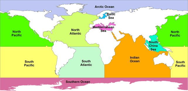
… but the Indian Ocean looks to me to be about 90% in the SH. That works out to be roughly 60% of the total in the SH but only 40% in the NH, which would mean 50% more water in the SH than in the NH. So if we considered the entire ocean temperature to be involved in the response to solar radiation there would be a greater response in the NH…
———————————————-
Just thinking to my self, I need a map.
Boom there it was in the link you posted, hey thank you..
“”So my question remains … why is the northern hemisphere ocean surface temperature twice as sensitive to a change in solar input as is the southern hemisphere ocean temperature?”””
Water and ice. Mass in the southern hemisphere is greater, we know this because of the wobble in Earth’s rotation.
Slower rotation more wobble, in the N. Hemisphere, creating different mixing regimes between the two hemispheres.
Faster rotation, well quicker wobble? lol but would affect mixing regimes.
More herky, jerky mixing patterns in the northern hemisphere.
I think that it is already expressed in tectonic boundaries, undersea volcanic ridges etc., for the N. hemisphere, too..
I suspect there is more upwelling of cold bottom water getting into SH currents.
@ Richard M, 5:10 pm June 18th, I was thinking the same thing. To me the continuous circulation of the Southern Ocean circulating around Antarctica ( the Westerlies) must have an effect year round. ( from the article: ” the southern hemisphere, on the other hand, the ocean surface temperature only swings 4.7°C, while the solar input varies by 287 W/m2 peak to peak. This gives a change of .0162°C per W/m2, about half the change of the northern hemisphere.”
If opening of the Drake passage and newly formed the ACC did cause global cooling (not just Antarctica) you would have to put your money on ocean currents being the difference. But it can’t be simply mixing with colder water, the cooling needs to be loss of energy to space (so what mechanism is in the models for how ocean currents affect the cooling of the Earth?)
Not long enough data to see correlation with max/min ice extent in the Antarctic for eg?
I had the same thought as Richard M. My understanding of the THC is that whereas NH surface movement is pretty much one-way (S-N) with the surface water sinking in the N latitudes and returning S via the deep ocean, SH surface movement is two-way with some THC cold water upwelling in the S ocean then moving N (Humboldt Current, eg.). Not sure exactly what or how much difference it would make, but maybe all N warming stays in the N, whereas some S warming leaves the S and adds to the N?
Yup, that helps. If we imagine the line of the equator oscillating back and forth seasonally from Tropic to Tropic, with the colour scheme moving in concert, we get a great image of the earth as a pumping heat engine. All that heat input at the tropics creating wind, ocean currents and clouds; and losing heat to space faster and faster as the heat carriers move toward the poles. More heat in, and I don’t think CO2 related warming is anything but a very weak theory, you just get a little faster heat engine.
AGW theory would have some value if it’s adherents actually took an interest in understanding earth’s weather and climate. Instead they just stumble endlessly over the same ground, determined to see what isn’t there.
“Just thinking to my self, I need a map.
Boom there it was in the link you posted, hey thank you..”
But it’s a highly distorted map ( only approx accurate at equator !!! ), to get a better understanding of the actual areas of land, water & ice look at a globe.
Try this interactive one https://earth.nullschool.net/#current/ocean/primary/waves/overlay=significant_wave_height/orthographic=74.33,2.59,277
• Use mouse button to rotate
• Click on ‘earth’ to change parameters
More info https://earth.nullschool.net/about.html …..lots to explore.
1saveenergy June 19, 2016 at 1:37 am
—————————————————-
Thanks, for the link, haven’t visited the wind map since the breakup of the N. hemisphere vortex this earlier this spring. Had to check the S. Polar vortex while there and found speeds up 213 mph. wow.
My bad, I said southern hemisphere mass. When meant water and ice greater.
Like Willis said, “”Often I start off by looking at one thing, and I wind up getting side-tractored merrily down some indistinct overgrown jungle path. “”
For me that’s an understatement and more like a way of life. sorta
From Earth’s wobble, back to the EEJ (equatorial electro jet), and its asymmetries between Northern and Southern hemisphere and the effect of variations in F10.7 flux.
First results from the Swarm Dedicated Ionospheric Field Inversion chain
A. Chulliat, P. Vigneron, G. Hulot
13 June 2016
Abstract
…”’They also reveal a peculiar seasonal variability of the Sq field in the Southern hemisphere and a longitudinal variability reminiscent of the EEJ wave-4 structure in the same hemisphere. These observations suggest that the Sq and EEJ currents might be electrically coupled, but only for some seasons and longitudes and more so in the Southern hemisphere than in the Northern hemisphere….”’
http://link.springer.com/article/10.1186/s40623-016-0481-6#Sec7
Not to mention that the Earth’s magnetic equator is mostly above the physical equator.
So,
“Better run through the jungle
Whoa, don’t look back”
https://youtu.be/EbI0cMyyw_M
How do you define your ocean surface temperature anomaly? Did you weigh local temperature anomalies by area? Did you exclude areas near equator?
Bear in mind the two polar oceans: the Arctic at 14 M km2 vs. Southern Ocean around Antarctica is 22M km2.
The middle/high latitudes in the southern hemisphere is mostly ocean. Cloudiness and weather patterns change little over the year there (the climate is hypermaritime, with little difference between winter and summer).
In the north these latitudes are mostly land. Land areas cool and heat up much faster than ocean which means that weather patterns and cioudiness varies much more in the north, and the cloudiness in particular strongly affects heat absorption by the oceans.
Yes, my thought was cloudiness too. That is the obvious missing variable in Willis’ article.
The solar radiation figures are TOA. The temperatures are surface. There is one big thing missing from that picture : the atmosphere.
Willis says:
How almost exactly? As you have pointed out in ‘lags and leads’ article the response never gets more than 90deg out of phase. Once the phase lags is around 2 months increasing heat capacity will make progressively less difference to the lag. A near infinite heat sink would only produce another month of lag so how much difference would 40% more make in terms of time lag and how accurate is notion that they are about the same?
Obviously it’s not either/or. It could be a combination of mixed layer depth and differences in cloud response to the annual cycle.
PS.
Here in the south of France, the greyest May and June I can recall in the 20y I’ve been living here. Apart from a very mild start to the year, it does not look like the summer is going to be breaking any records. ( Until it gets corrected and homogenised, of course. ).
Ok, I remembered something, did two quick checks, and present here a testable hypothesis for the hemispheric difference. It is well known that the Gulf Stream varies significantly seasonally, with a ~3 month lag (hello, tau). It is much stronger summer fall than winter spring ( the lag). It is a major heat transport mechanism variably warming the North Atlantic. But the Atlantic is a lot smaller than the Pacific, so by itself could not explain Fig. 1.
Googled northern hemisphere pacific currents, Sure enough, there is one: NECC. Bigger, more diffuse than Gulf Stream. But does the same thing, the same way, in the same direction. Aha!
So, is it significantly seasonal?
Well, according to Wang et. al., J. Phys. Oceanography 32: 3474-3489 (2002) YES.
So my quickie explanation hypothesis is that in the northern hemisphere, both the Atlantic and the Pacific have surface seawater heat transporting currents that have a strong seasonal component. The southern hemisphere does not, simply owing to the present position of the continents.
And those plate tectonic induced seasonally varying NH currents explain Fig. 1. Seasonal Water insolation response in the mixed layer is similar. But the seasonal heat distribution is not.
Interesting. ristvan , let me colour this in a bit.
If it is ‘seasonal’ as in 12mo seasons, which I presume is what are referring to, it means that it is driven by extra-tropical regions. The lag you report seems to roughly coincide with the SST temperature cycle.
This suggests that the mechanism may be evaporation. Due to the major ocean gyres, most of the water exiting the tropics is on western side of the basin. Increased evaporation at highter latitudes will lead to an increase in the gulf stream.
Wasn’t the panic about the gulf stream slowing down and stopping due to the first measurements done in the 70’s when things were cooling?
Do you have a good link for gulf stream flow data?
This is testable. All Willis has to do is to use a finer grid than hemispheres. Knowing him a little, that’s probably what he is doing now.
ristvan,
My first thoughts were the gulf stream and the NH current in the western Pacific, both flowing north. The second thought was the proportion of cyclones and hurricanes in the NH (compared to the SH) oceans that remove a tremendous amount of heat from the waters. One other thought is just how much solar energy is being reflected off the waters due to low solar angles at different times of day and season (I’m still pondering that one).
Anyway, Willis has a way of getting us to think!.
Yes. My first thought was that aside from the amount of land in the NH, another major difference is the considerably different pattern of major ocean currents in the two hemispheres. Unfortunately the differences seem too complex for simple analysis.
Ristvan and others, thanks for your comments about the Gulf Stream. The best info that I can find on the monthly variations of the Gulf Stream is here, see Figure 8. It hightlights a couple of problems with your theory.
The first is the shape of the monthly changes. For nine months or so, there is no significant change in the gulf stream. Then for two or three months or so during the summer, it speeds up. This is unlike the change in the hemispheric ocean temperature.
A larger problem, however, is that the amount of heat transferred by the Gulf Stream only varies about ± 15% from the mean. This is far too small to explain the two-to-one difference in the sensitivity of ocean temperature to TOA insolation.
So we have bad timing (summer only, no change otherwise) and bad amplitude (not enough change) arguing against the idea that the Gulf Stream variations are the answer to the question.
I have some stuff to do today, but at some point I plan to take a look at the sensitivity on a gridcell-by-gridcell basis …
Thanks to all who are contributing,
w.
“So my question remains … why is the northern hemisphere ocean surface temperature twice as sensitive to a change in solar input as is the southern hemisphere ocean temperature?”
And another interesting question would be: “What effect does this have on global weather patterns under different conditions e.g an El Nino or La Nina year; more cloud/ less cloud; explosive volcanic eruptions?”
Ken S
Good question to ask (and admit you don’t know the answer).
my guess: a lot of the southern heat gets transported to the northern hemisphere? in the atlantic the gulf stream originates from the south… so that might explain it for the atlantic. The pacific is another story as there there are two distinct gyres that “should” distribute the heat north and south…
but then how does El nino and la nina play on these north south transfers?
but my guess is the huge thermohaline conveyor belt. The “hot part of it” run south-north to cool and sink in the arctic and flow back south again. so is it maybe in that direction that must be looked?
however imvho i don’t think it explains it all, but it could alredy be a part of the mechanics behind this odd paradox, this paired with a hotter air mass due to the land surface that heats air faster then a water surface. that for sure will also do something to parameters like cloud cover etc
Don’t bet on the “huge thermohaline conveyor belt!” To the extent that it can covey water masses without materially changing their temperature, it is a phenomenon many oders of magnitude slower than the wind-driven circulation. In fact, it’s so slow that what\s known about THC is almost entirely the product of theoretical computation, rather than empirical observation.
I think you will find that the THC is a lot faster at the surface than it is at depth – and it is surface flow that matters in this case (Gulf Stream, Humboldt Current, etc).
by my knowledge the gulf stream is pretty “fast” and so are all the currents that run “over the deeper laying conveyor belt. generally the top of the conveyor belt runs at 2.5 to 5 knots so it crosses every 4 day span an average distance of 400 knots (or nautical miles) so at peak it goes at 9 km/h and at slowest it goes around 4 km/h so at fast stretches it crosses a distance of 900 km every 4 days or 400 km every 4 days for the slow stretches. so the fast surface part of the conveyor belt averages out of crossing 6000 km every roughly 40 days. Seen the twists and turns the slow downs, it would make the southern water to run north in a timespan of roughly 3-4 months
note that this is for the fast flowing first 70-100 meters of that belt, the deeper you go the slower the conveyor belt goes. However the range of the fast part of the conveyor belt is in the same range as the mixed layer. so that makes that the summer heated water for the southern hemisphere reaches the northern hemisphere in late spring- early summer in the northern hemisphere for the atlantic. For the pacific this lag will be more important as there the distances are bigger to cross.
but like i said this is an “educated guess, following the logic of ocean current speeds and directions” as just one of the perhaps many mechanisms that drive this paradox.
Mike Jonas:
By definition, THC is produced by thermohaline density differences. Thus it is essentially a vertical, gravity driven motion. By contrast, the great surface currents, such as the Gulf Stream, Humboldt etc., are WIND-driven currents. The dynamical confusion perpetrated in climate science through its “conveyor belt” notion, which fails to recognize THC as a snail-paced, minor adjunct to the wind-driven circulation, constitutes one ot many dismal failures. of its paradigms.
Frederik Michiels:
Where did the fantastic notion that ” generally the top of the conveyor belt runs at 2.5 to 5 knots” originate? Certainly not in the work of oceanographers or in the observations of sailors. Such high current speeds may be observed with tidal flows in estuaries, but are wholly unknown in the open seas., where 2.5 knots is very fast even for the major surface currents during their peak season.
1sky1 – I have always understood that although the THC is driven primarily by density (‘Thermo’, ‘Haline’), the term “THC” covers the whole cycle (‘Circulation’), ie. including the surface currents. If I have got that bit wrong, just call the surface currents something else and my comments still apply.
Mike Jonas:
It’s only dynamically confused “climate scientists” who imagine that the wind-driven surface currents subduct virtually en masse in certain areas to produce a “conveyor belt” circulation. That’s why they foster empty fears that massive introduction of fresh water off Iceland will slow or shut down the Gulf Stream. Oceanographers recognize that no such thing can take place. THC is generated by rather diffuse sinking of high-density masses of water, which displacement produces compensatory flows to conserve mass (think continuity equation). In fact, Carl Wunsch, perhaps the leading expert on oceanic circulation, calls the notion of a coherent conveyor belt “a fairy tale for adults.” For a masterful layman’s explanation of THC, see: http://ocean.mit.edu/~cwunsch/papersonline/thermohaline.pdf:
Also just a guess but it seems reasonable that there is a net transfer of heat from SH to NH by currents.
Air temperature can’t do much as the cooled air would hug the sea surface and the warmed water would stay there. The water can heat the air but the reverse is working against convection.
The idea of warmed (or cooled) fresh water impacting the ocean temps makes sense but how different is the quantity and the heat content of the fresh water?
Possibility: Circumpolar Current is in the Southern Hemisphere which serves to keep colder water IN that current versus the mixing cause by the in and out Arctic currents.
+1
Hmm.. South Pole is colder than the North Pole. South P. Is at elevation whereas North P. is at sea level so lapse rate maybe comes into play. Otherwise, one would expect the greater temp gradient from equator to Antarctic should drive more rapid heat transfer until the temp difference resolves itself. Instead, the circumpolar current somewhat interferes with expected heat transfer? Circumpolar current can exist and remain stable because there is open ocean around Antarctica? So, if what I laid out here is agreeable, where does equatorial heat go in the Southern Hemisphere?
Could it be that the lay of the land in the Indonesian Archipelago sweeps La Nina piled water more to the North than the South? It appears that when the trade wind driven equatorial current reaches the Philippian islands, the current splits with the greater part heading North.
“The Pacific North Equatorial Current is given a westward impetus by the Northeast Trade Winds (latitude 10°–25° N). Upon reaching the Philippines, the current divides, with the lesser part turning south and then east to start the Pacific Equatorial Countercurrent, and the greater part flowing north. This flow, known as the Kuro Current, moves north as far as Japan, then east as the North Pacific Current (West Wind Drift), part of which then turns south as the California Current, which joins the equatorial countercurrent to form the Pacific North Equatorial Current.”
http://www.britannica.com/science/equatorial-current
I have pondered the thoughts posted so far. I still think this is a fairly simple answer having to do with the physical properties of the Earth’s land forms and the currents that swirl around them, the Coriolis effect, and fluid thermodynamics: the asymmetric ocean currents (due to land barriers and Earth tilt interacting with the Coriolis effect) and their corresponding asymmetric atmospheric correlates causing a greater temperature swing in the NH versus the SH because of cold Arctic outgoing currents mixing in the basins, and the asymmetric split of the warm Pacific North Equatorial Current favoring the NH seasonal swing.
One more thought: My suggested mechanisms have seasonal swings. The trade winds that drive or calm the equatorial currents have long been known to have seasonal swings, and clearly Arctic melt is seasonal.
Since the specific heat of seawater is the same in both hemispheres, with one calorie required to raise one gram by one degree Celsius, the notion of “hemispheric sensitivity” is a slippery one, at best. What we have is differential annual warming of very differently distributed water surfaces, subject to very different wind, wave and cloud regimes. There is no simple, direct relationship between TOA TSI and surface insolation, let alone thermalization of the oceanic surface. Nor do oceanographic data show in “any given location the mixed layer all has about the same annual average temperature.” While the annual cycle is far smaller than on land, the annual average varies enormously with latitude, Quite apparently, the effect of highly different oceanic coverage and wind speeds in the high latitudes of the two hemispheres overwhelms the relatively minor difference that TOA TSI might be expected to make on hemispheric SST averages. .
The ‘average’ land (or ocean) in the Northern hemisphere is not at the same latitude as the ‘average’ land (or ocean) in the Southern hemisphere?
Instead of dividing the hemispheres at the equator, at what latitude would the division be, in order to equalise the two sectors? I really don’t know what this might imply. It’s just an idea looking for alternate clues.
Use the 10.6 cm Flux as a proxy for Solar energy actually reaching the Earth.
In addition, as per Pamela -> Possibility: Circumpolar Current is in the Southern Hemisphere which serves to keep colder water IN that current versus the mixing cause by the in and out Arctic currents
Somewhat related article, involving changes in earth’s wobble.
Though they never mention that Earth’s rotation speed has been increasing since the mid 90’s and more so in the time period used for this study. hmm still could be solar related…
NASA Study Solves Two Mysteries About Wobbling Earth
APRIL 8, 2016
http://www.jpl.nasa.gov/news/news.php?feature=6332
…A Sharp Turn to the East
Around the year 2000, Earth’s spin axis took an abrupt turn toward the east and is now drifting almost twice as fast as before, at a rate of almost 7 inches (17 centimeters) a year. “It’s no longer moving toward Hudson Bay, but instead toward the British Isles,” said Adhikari. “That’s a massive swing.” Adhikari and Ivins set out to explain this unexpected change.
…The researchers found the answer in Eurasia. “The bulk of the answer is a deficit of water in Eurasia: the Indian subcontinent and the Caspian Sea area,” Adhikari said.
The finding was a surprise. This region has lost water mass due to depletion of aquifers and drought, but the loss is nowhere near as great as the change in the ice sheets.
…So why did the smaller loss have such a strong effect? The researchers say it’s because the spin axis is very sensitive to changes occurring around 45 degrees latitude, both north and south. “This is well explained in the theory of rotating objects,” Adhikari explained. “That’s why changes in the Indian subcontinent, for example, are so important.”
New Insight on an Old Wobble
In the process of solving this recent mystery, the researchers unexpectedly came up with a promising new solution to a very old problem, as well. One particular wobble in Earth’s rotation has perplexed scientists since observations began in 1899. Every six to 14 years, the spin axis wobbles about 20 to 60 inches (0.5 to 1.5 meters) either east or west of its general direction of drift.
…When the researchers input the GRACE observations on changes in land water mass from April 2002 to March 2015 into classic physics equations that predict pole positions, they found that the results matched the observed east-west wobble very closely. “This is much more than a simple correlation,” coauthor Ivins said. “We have isolated the cause.”
The discovery raises the possibility that the 115-year record of east-west wobbles in Earth’s spin axis may, in fact, be a remarkably good record of changes in land water storage. “That could tell us something about past climate — whether the intensity of drought or wetness has amplified over time, and in which locations,” said Adhikari….
Carla, very interesting! Any thoughts on how this would affect sea level and its measurement?
Barclay E MacDonald June 18, 2016 at 9:00 pm
—————————————————————–
First off Mr. MacDonald, I found the article to be, well, misleading.
Blaming it on glowball warming/climate change.
Do I think that polar motion, gravity anomalys, melting ice, growing ice, land water usage, drought etc could and does affect sea level rise, yes.
But……….in the technical doc, there is a disclaimer of sorts that actually states that they did not use Length of Day (LOD), changes in Earth’s rotation rate.
How can a study on polar motion and the Earth’s various wobbles over a period from 2003-2015 and include rising and falling of sea levels at different locations around the planet and not include rotation rate ie LOD?
Now the different locations of the rising and falling of sea levels may be quite interesting for us, but one of the main mechanisms is missing.
Can’t always through the baby out with the bath water, Carla. Yea, sometimes the water is pretty dirty though.
The technical article:
Climate-driven polar motion: 2003–2015
http://advances.sciencemag.org/content/2/4/e1501693.full
Surendra Adhikari* and Erik R. Ivins
Just a little polar motion to excite our day..
http://aiuws.unibe.ch/code/erp_new.jpg
http://www.aiub.unibe.ch/research/code___analysis_center/gps_derived_earth_rotation_parameters/index_eng.html
Willis asks: “why is the northern hemisphere ocean surface temperature twice as sensitive to a change in solar input as is the southern hemisphere ocean temperature?
1) Solar input is normally expressed in terms of what units?
2) Temperature is expressed in what units?
3) What do you need to know to convert the units in the answer to question 1) to the units for questions 2)?
Your post answered part of the question: Peak temperature occurs two months after peak insolation.
Hope you don’t mind the questions. I’ve “lectured” on some aspects of this problem before. Perhaps the Socratic method will work.
Willis, what time span does your sea surface temperature cover?
I like ristvan’s current idea but cloud cover could also be an answer. Is there anyway to check cloud cover? If so, it could be good support for your cloud-thermostat hypothesis.
Thomas, the data covers March 2000 to February 2015.
w.
There is a typo in this sentence-
“On a global 24/7 average value, there is a peak-to-peak apogee to perigee swing of about twenty-two watts per square metre (22 W/m2).”
Should be about 250 W/m^2 p-p?
Thanks, Chris. The aphelion-perigelion change is indeed 22 W/m2. The rest of the change is from the changing tilt of the earth with respect to the sun.
w.
Willis-
OK. I missed the important ‘global 24/7’ in your sentence.
Thanks.
Is the Mediterranean Sea included in NH oceans?
A minor but important point. The “gee” in apogee and perigee refer to earth orbiting objects. The correct terms are aphelion and perihelion for a sun orbiting object.
Thanks, Bill, fixed.
w.
As usual, a thought-provoking marshaling of data. I have no idea what the explanation is. But a somewhat tangential comment follows.
As Mr. Eschenbach’s “Leads and Lags” post did, this one relies on a lumped-parameter, “one-box” model as an approximation. (Otherwise the “tau” parameter’s meaning is problematic.) But the period invariance Mr. Eschenbach mentioned in that previous post tends to militate against relying on such an approximation.
Period invariance is instead characteristic of what one might call an “infinite-number-of-boxes” model, or, more typically, a distributed-parameter, diffusion model. As one might conclude from comments to the post I wrote about that some years ago, there is reason to suspect that a hybrid of lumped- and distributed-parameter models may be superior to both.
Again, this is somewhat tangential, but Mr. Eschenbach’s reference above to inferring “tau” from lag suggested it might be worth reminding readers that the theoretical basis for that inference is questionable.
Thanks, Joe, always good to hear from you. My point was simple. If the lag in both hemispheres is the same, which it demonstrably and measurably is, then it is unlikely that the amount of ocean mass involved is radically different.
As to using the simplest model that fits the data, I plead guilty … as I showed in the previous post, such a model emulates the observed ocean temperature to a very high degree of fidelity (see Figure 5).. Given that accuracy, what would be the justification for unnecessarily multiplying entities in violation of Occam’s Razor?
w.
I apologize for going off on a tangent. I wasn’t attempting to dispute the overall point that the mass being heated is unlikely to provide the entire explanation for the gain difference. My comment was meant only as an aside, directed to those of a more-mathematical bent, who would recognize that the relationship between phase and time constant prevails only for one-box models and that for a one-box model the gain difference upon which you remarked admits of only one explanation. , where
  is equilibrium gain,
  is
is  ,
,  is the time constant, and
  is heat capacity, while phase is
  . That is, there are only two parameters: heat capacity and equilibrium gain, sometimes called the “Planck sensitvity” at this site. So, if the yearly-variation gain really does differ between hemispheres that exhibit the same phase, the equilibrium gain does, too: the Southern Hemisphere’s radiation-emission change for a given change in temperature exceeds that of the Northern Hemisphere.
Specifically, the yearly-variation gain for a one-box model is
As I say, for those of a more-mathematical bent, that would be the only possible conclusion if one were to stick with a one-box model and truly believe the observed gain difference. Again, though, this is only tangential to the questions your observation raised.
Joe: One doesn’t need a very sophisticated model to understand why seasonal warming is twice as great in NH than SH oceans. 80% of the SH is ocean, 60% of the NH is ocean. The mixed layer in the NH is 47 m deep in the NH and 68 m deep in the SH. That means the heat capacity of the SH is roughly double that in the HN.
The concept of climate sensitivity (K/(W/m2)) makes skeptics think that every forcing can be converted into a temperature change without considering: 1) heat capacity 2) the time required for temperature to change, 3) how Planck feedback (or more accurately the climate feedback parameter) gradually negates the radiative imbalance associated with a forcing. 4) how quickly heat penetrates below the mixed layer (which is defined by seasonal change). Every time I comment on some aspect of this (real) physics, I get no response, Do you understand this phenomena?
It is trivial to calculate that a +1 W/m2 radiative imbalance is capable of warming the planet at an INITIAL RATE of 0.2 K/yr (assuming that all the change occurs within a 50 m deep mixed layer). This is a good place to start thinking about Pinatubo. A +100 W/m2 imbalance can warm at an initial rate of 1.7 K/month. Or, if we use the numbers above, 1.07 K/month in the SH and 2.0 K/month in the NH.) This would a reasonable place to start thinking about seasonal warming – if surface temperature were in equilibrium with incoming radiation. Starting with climate sensitivity is hopeless.
Total heat capacity of the Northern hemisphere is less than the Soithern; more land in the North. So other things being equal, the North should have greater seasonality than the South, and it does. The influence of land temps on water temps is tempered, of course, but greater seasonality in the ocean in the north is a reasonable consequence of lower total heat capacit in the north.
At the end of the day it must be about the earth’s preferred energy configuration.
As per the observation that the two hemispheres have the same albedo, and in line with to the second law of thermodynamics, the earth strives to be as thermally homogeneous as it can be within the constraints the earth imposes. (ie spherical, rotating, with ocean currents and land masses as well as composition and density of its atmosphere to name a few) The earth’s climate system at a large scale over long time periods achieves that and one of the mechanisms that can change is cloud cover.
So…with less surface area, the Northern hemisphere oceans need to be warmer to get the “right” amount of cloud to make all that happen. Having said that, it could also be about the right amount of cloud cover to get to the preferred configuration if we’re out of whack currently…
Willis, if you can, you should map the interrelationships.
Cheers.
“So that’s today’s puzzle—why should the ocean in the northern hemisphere warm twice as much as the southern hemisphere ocean for a given change in solar forcing?”
WR: suggestion for tomorrow’s puzzle: why should the ocean in the northern hemisphere cool twice as much as the southern hemisphere ocean for a given change in solar forcing?
My idea: energy flows from warm to cold. The average temperature of the sea is higher than the average temperature of the land. So sea warms the land. The NH has relatively more land and less sea than the SH. So on the NH less sea has to warm more land. Therefore NH oceans will cool faster than the oceans on the SH.
Except in NH Summer the land is a higher temperature than the sea.
If so, in summer time NH land masses will warm the sea. And in NH winter time very cold land masses will cool the sea strongly. Resulting in a large NH sea temperature swing.
Doesn’t worK.
The reason land temps have a larger swing is because they have a lower specific heat capacity. So to the same degree as they warm more, they have less capacity to warm anything else. They are not creating energy. There is no means for land to add more heat than would be falling on the same area if it were ocean.
Plus land can only affect sea via the air and the degree to which the atmosphere can heat the ocean is limited. There is some horizontal heat transfer which is how oceans stabilise land temp swings. To the extent that land summer temps warm the air above, most of that heat is going to go up not down.
Greg, it is about averages. It will be interesting to see the yearly facts. Land temperatures in the NH in wintertime are far down: land can absorb a lot of energy from the sea.
There is a [huge] horizontal and vertical energy transport. Compare for example the high surface winter temperatures in Western Europe (with a lot of oceanic westerlies) with the winter temperatures in East Asia at the same latitude to see the effect of the horizontal energy transport. Vertically, the energy in the air brought upwards by low pressure systems at sea lowers down in high pressure areas at land.
Land masses are losing a lot of energy in wintertime. Where does the energy come from? Without the sun, Earth would only have a temperature around 3K or so. What keeps the high latitudes in Siberia in wintertime at temperatures of around 240K? The high latitude land area’s lack sun energy and there is nearly no energy available in the subsurface: it radiates quickly outward. Only the sea is containing enough energy to keep Siberia relatively (!) ‘warm’ in wintertime. In doing so, the oceans at the NH cool down strongly.
So the story is about ‘losing heat’. And about the total heat content of the subsurface of the NH and the SH in which the sea plays an overwhelming role.
I think that specific heat content is a worthless concept things do not contain heat , if enough energy was put into the ocean it would boil away but the solid part of the earth would still be there absorbing that energy. I think that the solid part of the earth heats up faster than the oceans because all energy is absorbed at surface level and there is no deep penetration as there is in the oceans
There is very little contract between land and sea. The interaction sea -> air ; air -> land. The amount of air in contact with the surface does not contain much sensible heat.
If you want a link between winter temps on land and sea I would suggest it is to do with cloud cover.
Also remember when talking about “land temperatures” we are usually measuring land, near surface air temperature not the temperature of the land. So a lot of this will be warmer marine air blowing over land, not transferring heat to the land.
The warm ocean air radiates the heat to space more easily when the atmosphere is cold and dry above Greg
Sarah Kang in he linked paper below agrees with you Wim Rost
Surely the answer lies in the largely landlocked ocean basins of the N pacific and indian oceans. The southern parts of these two are regularly flushed out by the vigorous circumpolar westerlies and the southern ocean west to east current. Northern ocean basins do not have this and are largely recycling water in trapped gyres with little direct access to colder polar water.
Willis, I’m true to my little rhyme:
Climate changes with the sun,
The ways oceans run
And clouds, so complexly begun.
That’s my story and I’m stickin’ tuit.
Sarah Kang and Richard Seager had an interesting paper that revisits a paper from James Croll done in 1870. Croll is the founder of astronomical theory of ice ages. They hypothesize that ocean transport of heat from the SH across the equator to the NH is responsible for the temp difference between the hemispheres already noted in 1870 before added CO2 could be the cause.
“”Croll!s arguments for how currents accomplish this transport was stated as follows:
Since there is a constant flow of water from the southern hemisphere to the
northern in the form of surface currents, it must be compensated by undercurrents
of equal magnitude from the northern hemisphere to the southern. The
currents, however, which cross the equator are far higher in temperature than
their compensating undercurrents; consequently there is constant transference of
heat from the southern hemisphere to the northern.
“”
http://ocp.ldeo.columbia.edu/res/div/ocp/pub/seager/Kang_Seager_subm.pdf
Ocean heat transport could be moderating the SH temperature delta T and exacerbating the NH delta T.
In my opinion this is part of the explanation, if not the most significant part of the explanation. I made a point similar to this in Willis’ old article Radiating the Oceans. Ocean heat transport is a key component of understanding climate on this water world of ours.
Ozone?
Production/destruction processes are constant in the atmosphere and their rates are effected in a big way by both angle of incidence and intensity of UV rays from the sun. So in January, the SH is turned more directly toward the sun AND it is getting a higher dosage due to being at perihelion. From there, it gets real complicated fast as you’ve got a lot of different processes going on, including ozone being a GHG, mopping up other GHG’s like methane through chemical reactions, and as the Dobson units increase, direct absorption of incoming UV at altitude instead of lower down in the atmosphere or even at surface.
My expectation is that the real explanation will be the sum of several different process. But I thought I would through this one out there for cosideration.
agreed. it is the amount of UV allowed through the atmosphere that heats the oceans the most. But it is not only ozone being formed TOA; there are peroxides and nitrogenous oxides as well being formed by the most energetic particles released from the sun. They do the same thing: restrict more UV coming through. (e.g. compare spectra of H2O2 with ozone).
[perhaps off topic: there never was a ozone hole in the SH. Peroxide is formed preferentially to ozone if more OH radicals are available.]
HenryP, you might find this article of interest regarding solar spectrum ocean heating.
http://journals.ametsoc.org/doi/pdf/10.1175/1520-0485(1994)024%3C1652:HRWTUO%3E2.0.CO%3B2
Turning the question round the other way then why does the southern hemisphere ocean respond less to solar radiation than the northern hemisphere ocean. My answer to this question would be that the southern hemisphere has a lot more sea ice than the northern hemisphere at a higher latitude which makes the water colder when it melts.
sea ice as thermal ballast damping excursions makes sense to me
Willis wrote: “”Why is the northern hemisphere ocean surface temperature twice as sensitive to a change in solar input as is the southern hemisphere ocean temperature?
Answer (to a first approximation): The heat capacity of the SH is twice as big as the heat capacity of the NH, so the same seasonal change in insolation produces half as much warming in the SH as in the NH.
60% of the NH is covered by ocean with a mixed layer averaging 47 m deep. 80% of the SH is covered by ocean with a mixed layer 68 m deep. Ignoring the heat capacity of land and atmosphere, the ratio is 1.93:1.
Due to the eccentricity (3.5%) of the earth’s orbit, the SH receives 17 W/m2 (7%) more during its summer than the NH. The rest of the 22 W/m2 is due seasonal snow cover in the NH which increases the earth’s surface albedo during winter in the NH. These two factors oppose each other, so the difference is 12 W/m2. The seasonal change in radiation is about 250 W/m2. So the seasonal change in insolation is about 5% bigger in the SH.
To a second approximation, the ratio of warming should be about 1.84:1, which is still within reasonable agreement with observation. This ratio will drop a little if we account for the heat capacity of the land and atmosphere. We may also need to accounted for any different in seasonal changes in cloud cover between the NH and the SH.
The difference between climate sensitivity and ordinary heat transfer causes massive confusion. When discussing climate change, we convert a forcing usually measured in terms of W/m2 into a temperature change usually measured in degK. If you do dimensional analysis of these units, you will find that these units are incompatible: In ordinary heat transfer, Watts is energy/time, W/m2 is energy/time/area, temperature proportional to energy/VOLUME (or energy/mass). Heat capacity is the factor used to convert energy to temperature. The depth of the mixed layer connects the area of the material being heated (the ocean) with the volume of the material being heated by a change in insolation. The warming of the NH and SH are problems of ordinary heat transfer.
Equilibrium climate sensitivity is not an ordinary heat transfer problem. As the planet warms, it radiates more heat to space and any radiative imbalance at the TOA gradually drops to zero – assuming a constant forcing. For an instantaneous doubling of CO2, we have an immediate radiative imbalance of 4 W/m2 that gradually drops to zero, mostly in the first decade. That energy (power * time = energy) goes into warming the ocean – but the depth of ocean (heat capacity) being warmed is far greater than the seasonal mixed layer. ECS allows us to convert a forcing (W/m2) into warming only after a long period of time (decades to centuries) and the depth of the mixed layer is irrelevant to this process. TCR allow us to convert a gradually increasing forcing to warming over one or more decades -which only gets us part way to equilibrium, which is why TCR is about 2/3 of ECS.
The concepts of climate sensitivity (ECS and TCR) can NEVER be applied to seasonal change. Seasonal temperature change has nothing to do with reaching or approaching equilibrium! By the time peak warming is reached in August in the NH, peak insolation is long past. NH SST is 1 K warmer in September at the equinox than in June at maximum insolation! Due to the high heat capacity of the ocean, the temperature of the ocean lags far behind changes in insolation.
The importance of heat capacity can also be seen by looking at local temperature. Away from the coastal areas, land temperature in the NH usual peaks in July. In the Arctic, minimum sea ice occurs in mid-September (a week or two before the equinox), because heat need to melt 1 meter of ice is equivalent to that needed to raise the temperature of a 40 m mixed layer by 1 K. .
The cooling observed after volcanic eruptions is somewhat less than expected from climate sensitivity for similar reasons – the planet hasn’t had time to reach or approach a new equilibrium temperature before the radiative forcing from volcanic aerosols begins to diminish.
Frank, you are full of assertions with nothing to back it up.
After Mt. Pinatubo, radiative forcing peaked in less than six months, yet the cooling continued for 3 or 4 years.
Sensitivity to volcanoes is much less than “expected” since climate is less sensitive than those expectations. It’ s the expactations which are wrong, nothing else.
https://judithcurry.com/2015/02/06/on-determination-of-tropical-feedbacks/
The time constant I derived from ERBE data was about 8mo.
I also showed that the volcanic forcing was constiderably stronger than more recent values used by modellers, thus the climate sensitivity is much less. My value was very similar to calculations done by the same climatologists in 1990 before they went off the rails distorting everything to back up AGW.
Of course, if CS is less for volcanic forcing it is very likely to be less to GHG. Distorint both values is why they are running hot since 2000, a period with no major volcanoes to counter their exaggerated AGW.
Greg: I wrote a long discussion about the 2X larger seasonal warming in the NH. Then I commented that the same principles apply to volcanos. Maximum cooling occurred 1.5 years after Pinatubo (not 3-4 years). Warming over years 1.5 to 3.5 restored pre-eruption temperature. The data is noisy. IMO, the best analysis of Pinatubo was done by Paul_K at Lucia’s.
http://rankexploits.com/musings/2012/pinatubo-climate-sensitivity-and-two-dogs-that-didnt-bark-in-the-night/
Perhaps your comments apply to seasonal temperature change as. Well as Pinatubo. If you understand the factor-method for doing scientific calculations, we can have an intelligent conversation about how to calculate the temperature change produced by a radiative imbalance. If you believe that a radiative imbalance can be simply converted to a temperature using climate sensitivity, ask yourself how long a forcing must be applied before the resulting temperature change is complete? One day? One week? One month? One year? One decade? One century? Justify your choice. Climate sensitivity controls the amount of temperature change after equilibrium is reached. Heat capacity controls the RATE at which equilibrium is approached. Equilibrium requires no radiative imbalance. Read Paul_K.
Well done and thought provoking as usual. Just to prove that I actually read it, in the eighth paragraph “(However, monthly changes are still largest and the surface and decrease with increasing depth.) “, I’m pretty sure the first “and” should be “at”
No difference when you exclude 60 N/S – 90 N/S? That’s a bit of a surprise. Would it be worth taking a shot at excluding 40 N/S – 90 N/S to eliminate the Southern Circumpolar flow? Or more generally, in what 10 or 15 degree latitude bands does the difference show up?
Look at the globe . There is a circulation in the southern ocean that cant be repeated in the Northern.
This gives a better distribution of ocean heat.
Roaring 40s and screaming 50s.
That is my guess.
The graph is extremely smoots for a scatterplot, of course it must be some sort of hemispheric smoothed average. Do you have a real scatterplot of all temperature vs insolation?
It is clearly each point being the average of each month across the years of the data.
The spatial distribution of ocean regions and continents is unevenly arranged across the Earth’s surface. In the Northern Hemisphere, the ratio of land to ocean is about 1 to 1.5. The ratio of land to ocean in the Southern Hemisphere is 1 to 4. This greater abundance of ocean surface has some fascinating effects on the environment of the southern half of our planet. For example, climate of Southern Hemisphere locations is often more moderate when compared to similar places in the Northern Hemisphere. This fact is primarily due to the presence of large amounts of heat energy stored in the oceans.
It seems to me that the differences between total volumes of water in the two hemispheres would have a major impact on the amount of solar heating measured, as might the temp of the winds blowing from the landmasses in the northern hemisphere. I know that water has quite a (relatively) high specific heat (1), and if the total volume of water in the southern hemisphere is significantly higher than the northern hemisphere – assuming other factors such as mixing, overall depth, currents etc being roughly equal – then that greater volume of water in the southern hemisphere would take that solar heat and “divide” it into a much greater volume of water, which would mean overall lower temps.
Yes, the direct solar heating of the seawater per unit of surface area would vary by the total watts/m2 available from the sun, but the (possible) additional heat blown by the trade winds coming from the land might be am uncalculated but important factor?
There are no inductive inferences.
Karl Popper.
“However, two things argue against that conclusion. One is that the mixed layer in the southern hemisphere is about 45% deeper than in the northern … but the northern hemisphere sensitivity of temperature to incoming solar is double, not 40% larger.”
Would the relationship be linear? I doubt it.
“The other thing that argues against the mixed layer difference is that the thermal lags in the two hemispheres are very similar, with peak temperatures in each hemisphere occurring almost exactly two months after peak solar.”
That’s dominated by the timing of seasonal northerly and southerly displacement of atmospheric circulation.
Fig. 12
Evolution with UT and season of the maximum absolute value of the primary current function Ψ1 in the Northern ( ΨN ) and Southern ( ΨS ) hemispheres. ΨN and ΨS represent the total currents (in kA) flowing in the dayside vortex for each hemisphere. F10.7=100 SFU
Willis, Congratulations; if I am right you have found something very important. These plots are servo diagrams of the feedback systems of the North and South hemispheres. Notice the southern hemisphere plot is very controlled and is tight indicating high feedback and the northern plot is loose indicating a lower feedback ratio. This is probably due to the higher percentage of the south being in contact with the Ocean.
Willis, I am sorry that my comment was so short; I was in a hurry. I believe that you have found the master thermostat for the Earth’s climate. Many researchers have hunted for this over the years. The comments on your post do not recognize that both the high and low temperatures are being controlled.
I will look primarily at the Southern Hemisphere curve and compare it to the Northern Hemisphere. The curve is an extended ellipse with the temperature being controlled about the major axis. Both high and low temperatures are controlled with respect to the axis. An ellipse has two centers of rotation, where a thermostat or reference should be only one point. However, in this case, the center could be moving with the input causing the effect of an ellipse. The question would be what would serve as a reference. Bob Tisdale has been commenting and showing on his graphs that the Earth’s temperature does not change smoothly; but rather moves in jumps primarily in concert with El Nino warming and remnants. This would indicate that the Earth’s temperatures follow the Ocean surface temperatures. Since the Oceans’ surface temperature changes with seasons the reference would change and the ellipse form would be expected.
How would the Ocean surface temperature control the Earth’s temperature? The Hadley cells, The Ferrel, and the Polar cells move heat from the Equator to the polar regions. The horse latitudes form a mixing of the high side winds from both the Hadley cells and the Ferrel cells; somewhat like the summing junction of an operational amplifier. The mixed winds, which could also be considered an error signal, flows back to the Equator on the low side of the Hadley cells and is in contact with the Ocean’s surface. The surface temperatures add or subtract energy and prepare them to enter the uplifting at the Equator. The energy and moisture they carry affects the thunderstorms and uplifting at the ITZ. More energy increases the wind flow and serves as a negative feedback cooling the Earth.
I hope this is complete enough for you to use.
Thanks, John
I am intrigued by your comment
Samuel C Cogar
June 19, 2016 at 9:00 am
Thanks, Samuel. Several other people have made the same point. You are correct when you say:
However, what you and others seem to be missing is that because the SH has a larger ocean area (43% NH, 57% SH), it receives proportionately more solar than does the northern hemisphere ocean. Remember, the incoming sunlight is measured in watts per square metre … so the ocean with more square metres gets more sunlight.
This leaves only the depth to vary between the two hemispheres … but as I pointed out, there’s not much difference in the mixed layer depth. In addition, the two hemispheres have the same lag (peak insolation to peak temperature) and thus appear to have no difference in the equivalent mass of water involved.
Best regards,
w.
Willis: “the two hemispheres have the same lag (peak insolation to peak temperature) and thus appear to have no difference in the equivalent mass of water involved.”
What is the exact lag for each hemisphere ? Are you saying it’s 2mo+/-0.5 mo ?
Could you say how are you evaluating the lag and to what accuracy?
What would the implied difference in mixed layer be if SH was 2.5mo ?
It seems that you are saying the lag is about equal ( with no indication of just how different the could be on available information ) . It is now “the same lag …. and thus appear to have no difference in the equivalent mass of water involved.”
Totally tossing out this option seems a bit radical on the evidence. It is not a binary choice. It seems unlikely that this is not a factor. Quite likely not the only one.
could you comment on the accuracy of lag in each hemisphere, and how much 2.5mo would mean for the depth calculation?
Best regards, Greg.
Greg, as mentioned in the caption I splined the monthly values to give what is shown in Figure 1. It’s splined to the nearest degree, and I used it to calculate the lag. The two hemispheres have the same lag to the nearest degree.
Best regards,
w.
The smaller pot is not only smaller, but forces polewards currents moving some heat North, where West Wind Drift does not do that on the SH. Also asymmetry may arise from places of upwelling and sinking being not symmetrically positioned.
I would think that a difference of 45% would not be negligible.
Werner Brozek June 19, 2016 at 3:32 pm
Thanks, Werner. I’d said.
The issue is not that the difference is “negligible”, that’s your word, not mine. There are two issues. First, the difference in the mixed layers is not large enough to explain the difference.
Second, and more important, if there were a difference due to different masses of water involved in the cycle in the two hemispheres, then the lag in one hemisphere would be larger than in the other … but the lags are the same.
w.
Thank you!
Perhaps different numbers need to be compared. Instead of comparing 0.032 to 0.016 since these numbers talk about areas and not volumes, the number 216 should be compared to 287. 287 is 33% more than 216. Perhaps this explains 33% of the 45% and we just need to explain the other 12%.
Willis Eschenbach — you state that “but as I pointed out, there’s not much difference in the mixed layer depth”. A comment above presented a significant difference between NH and SH mixed layer depth with NH is smaller than SH.
Dr. S. Jeevananda Reddy
The S Hem would not lose heat to the land as much as the N Hem does.
Willis Eschenbach June 19, 2016 at 11:02 am
However, what you and others seem to be missing is that because the SH has a larger ocean area (43% NH, 57% SH), it receives proportionately more solar than does the northern hemisphere ocean. Remember, the incoming sunlight is measured in watts per square metre … so the ocean with more square metres gets more sunlight
———————————————————–
You know, Willis, that does make sense.
But in reality there are other processes affecting how much and where.
The SWARM satellites are doing more than just measuring magnetic fields on Earth.
First results from the Swarm Dedicated Ionospheric Field Inversion chain
http://link.springer.com/article/10.1186/s40623-016-0481-6#Sec7
Fig. 12
Evolution with UT and season of the maximum absolute value of the primary current function Ψ1 in the Northern ( ΨN ) and Southern ( ΨS ) hemispheres. ΨN and ΨS represent the total currents (in kA) flowing in the dayside vortex for each hemisphere. F10.7=100 SFU
Thanks Carla, I was not aware of this work.
I have always wondered why the line of cloud indicating the ITCZ drifted upwards between S.Am and Africa. The following plot seems to show the reason.
Willis,
Very cool. I have two suggestions to make re the hemispheric difference.
First, the southern hemisphere has more clouds than the northern hemisphere. The difference is sufficient to give both hemispheres virtually identical albedo, even though surface albedo is higher in the NH (more land, more desserts, more snow and ice). So a smaller fraction of sunlight makes it to the surface in the SH, reducing the magnitude of the seasonal swing in insolation and therefore the temperature change.
Second, the NH has more land than SH and land heats up more readily than water. The effect is large enough that the global average temperature is highest during NH summer, when the earth is farthest from the sun. That effect is mainly over land, but heat does not stay in one place. So some of the effect should be transferred to the ocean, producing a larger temperature swing in the NH.
I could dig up references to support the above, if needed.
Thanks Mike. That makes a lot of sense. It seemed that the albedo being the same went counter to my initial intuition that the difference was due to cloud. What you say shows they are not contradictory.
The cycle here is 4 time units, let’s call them seasons. So the lag you are referring to here is the range between 4 and 5 time units on the graph. 2/3 of a season ( 2mo) seems to match a tau of about 3 or 4 on that scale ( estimating 4.67 by eye ).
2.5/3 ( 2.5 mo ) looks like it could be tau of 8 or 9. That is what I mean about it moving quickly in that region, so even a week or two of difference is the lag between N and S could correspond to a significant change in tau , and hence depth calculation.
That is why I think you need to be a bit clearer how much “the same” they are before dismissing the impact of differences in mixed layer depth.
I would start by asking ‘why are the mixing layers of different depth?’ Ocean currents can circumnavigate the globe in the Southern Ocean and we know that cold water at depth migrates north. Just some questions
So my question remains … why is the northern hemisphere ocean surface temperature twice as sensitive to a change in solar input as is the southern hemisphere ocean temperature?
Willis, I think this is a quantitative question. You have to use a climate model to answer this question. I have used a simple gridded EBM model (solar insolation and reflection and other radiative parameters from CERES, horizontal and vertical convective as adjustable parameters). I found for the monthly hemispheric ocean temperatures in °C
Month ;tomNH ;tosNH ;Diff ;tomSH ;tosSH ;Diff
Jan ; 15,1; 15,9; -0,8; 17,7; 18,8; -1,1
Feb ; 14,9; 14,6; 0,3; 17,8; 20,3; -2,5
Mar ; 15,5; 14,3; 1,2; 17,6; 20,9; -3,3
Apr ; 16,9; 14,9; 2,1; 16,8; 20,3; -3,5
May ; 19,0; 16,2; 2,8; 15,7; 18,7; -3,1
Jun ; 20,7; 17,8; 2,9; 14,6; 16,6; -1,9
Jul ; 21,9; 19,4; 2,5; 13,7; 14,4; -0,7
Aug ; 22,4; 20,7; 1,7; 13,4; 12,8; 0,5
Sep ; 21,7; 21,4; 0,3; 13,6; 12,3; 1,3
Oct ; 19,8; 21,1; -1,2; 14,4; 13,0; 1,4
Nov ; 17,8; 19,8; -2,0; 15,6; 14,6; 1,0
Dec ; 16,0; 17,8; -1,8; 16,8; 16,7; 0,2
Jan-Dec; 18,5; 17,8; 0,7; 15,6; 16,6; -1,0
tomNH are the measured Ocean temperatures (HADCRUT 4) and tosNH the simulated temperatures, and so on. The largest swing is between the temperatures of Feb and Aug. It is 6.1°C for NH (measured 7.5°C) and 7.5°C for SH (measured 4.5 °C). So the difference still exists. My proposal: It is caused by the different circulation patterns of the atmosphere and the oceans in both hemispheres. This is not described very well by my simple model.
One cannot begin to answer that question until one looks not only at oceanic volume, but also currents. Since currents operate in 3 dimensions, one needs to know at what rate near surface volume is sequestered to depth, and at what rate oceanic currents distribute a given volume of ‘warm’ water in a poleward direction. Of course, it is much more complicated than that since ‘warm’ water pools in various areas such as the Gulf of Mexico, off the West coast of Africa etc.
As I mentioned to years ago when discussing Radiating the Oceans, one cannot look at the radiative budget of the oceans to determine whether the oceans freeze. The oceans will not freeze (even absent DWLWIR) because there is sufficient solar irradiance being inputted in to the equatorial/tropical oceans to keep that area ice free, and thereafter, ‘warm’ waters from that area are distributed globally via ocean currents.
As mentioned to you, if you look at the radiative budget of oceans at the same latitude, eg. in and around the coast of Iceland and say equivalent latitude in the Baltic, one ocean freezes in Winter, the other does not. the reason is ocean currents which operate differently in these two different areas.
Just a thought: Given the much larger land area of the NH, it follows that the ocean areas above the continental shelves will also be much larger, proportionately, than in the SH. So, the total volume of seawater in the Southern Hemisphere is much larger than the ocean area itself suggests. The rest of this discussion is well above my pay grade- but interesting, nevertheless…
Rivers. There are twice as many rivers emptying warm water into the NH Oceans as there are into the SH oceans.
@Pamela
the connection of this problem to bio growth looks remote to me.
I am sitting with a similar conundrum
my results indicate that the SH never warmed in the past 40 years, even though maxima were rising sharply, even more sharply then in the NH.
It looks like all global warming happened in the NH (during the past 40 years)
yet there never was any warming in the SH. For example, here in southern Africa.
minima have been falling rather than rising (as AGW would suggest if GW were a global problem)
It looks to me that as other writers have suggested, the (extra) heat produced in the SH during the past 40 years was shipped to the NH by the weather, .e.g. by thunderstorms…..
I am sure Willis knows all about that?
I don’t follow you. Bio growth was not a listed factor in my posts, and the central issue of Willis’ post is the hemispheric asymmetrical nature of seasonal changes in SST as a function of the orbital influence on Solar heating.
@John the retired engineer
I know what controls maxima
I am still puzzled as to what controls minima?
Henry, as far as I can tell, it is the same mechanism. The lower water temperature will be the reference that the system corrects to, and the actual resultant temperature will be determined by the feedback ratio. The system corrects based on the ratio of the open and closed loop gains and there will be some uncorrected error in the cold direction.
The widely divergent, often self-contradictory, speculation here about the annual hemispheric SST inequality is symptomatic of the inadequacy of climate-science paradigms in explaining geophysical realities. Concentrated upon over-simplified equilbrium responses to radiation, the complex effects of modulation of surface insolation and of thermal energy storage–particularly by the ever-evaporating, ever-flowing oceans–are often greatly overlooked.
Sailors have known for centuries that there is nothing in the NH to compare with the roaring forties and whistling fifties for persistence and scale of high winds and strong currents. Physics tells us that evaporation increases with windspeed.. Oceanographers have long recognized not only the unmatched scale of the mass transport by the Circumpolar Current, but also the upwelling all along the edge of the Antarctic ice-shelves. Contrary to the mere horizontal redistribution of hemispheric heat by surface currents, or the limited downward mixing of surface heat, it is the perpetual upwelling of near-freezing water in those and higher southern latitudes that is largely responsible for the persistent hemispheric inequality of SST.
Thank you for this very accurate point of view. From these few lines I learned much more than from the whole rest!
Does that mean (yes: oversimplified) that this hemispheric inequality would be by far lower if the Antarctic was not a continent?
Since the presence of a coast is essentail for truly deep upwelling (in contrast to the shallow circulation of Langmuir vortices in equatorial upwelling) , the absence of the continent Antarctica would certainly reduce the inequality in the forties and fifties. The question remains, however, whether the additional mass of near-surface water thus made available at higher latitudes for mixing by the ferocious winds would fully compensate the hemispheric average for that zonal reduction. .
thinking about the weather…
is it not that the amount of weather is determined by the rate of change in the delta T between the poles and the equator?
perhaps I should refer to
https://wattsupwiththat.com/2016/06/18/hemispheric-ocean-temperature-sensitivity/#comment-2241766
to illustrate
….
to illustrate that I have the same problem as Willis about the transfer of heat from SH to NH
As promised above, a more detailed look at the issues …


I’ve added a grey line at the global average sensitivity, which is 0.02 °C per W/m2.
I’ve also added the graphics to the head post.
Comments welcome,
w.
Then it appears that greater NH mixing from chilled Arctic water versus less mixing in the SH from chilled Antarctic water could be plausible. It also looks like the asymmetrical split of the equatorial current favoring the NH is also plausible. These issues would show up using season as the independent variable.
Willis,
You have shown the incoming TSI in your opening diagrams. Unless the outgoing TSI is constant, this gives only part of the picture. Roughly the SS temperature is set, with a lag, by the difference between incoming and outgoing.
Just as incoming TSI peaks in January in the SH , on the dark side of the globe the outgoing TSI has a feature that sits in the dark for months, namely the South Pole plateau and its surrounding sea ice. Six months later the Arctic ice mass does likewise, but it is smaller and warmer. Because of their size differences, the ice masses leave less ocean area to give SSTs in the dark SH winter and the waters are further from the Pole and thus warmer than the NH summer case. The warmer they are, the more outgoing radiation they give to cause overall cooling.
So, the outgoing TSI is different, NH versus SH, in their respective winters.
There is a further asymmetry because of the elevation of the Antarctic plateau causing it to be cooler than the air above it. This means that its outgoing flux to space starts in the air as opposed to the ground everywhere else. This causes a different heat loss scheme in the SH dark side, compared to NH dark side six months later. One consequence is that different regimes exist to set the SSTs in those two places.
One can speculate about the directions of these effects but a better scenario becomes possible if diagrams of incoming TSI are complemented with similar ones for heat loss from outgoing radiation.
Willis has described simple event diagrams. It is not hard to imagine many other effects to explain them, as others have done above, but hard to know of their interdependence and relative weights.
Geoff, don’t put too much trust in TSI. The instruments measuring it might be less reliable than you think.\ not only that:
The incoming solar energy has a chi-square distribution but the top is not constant. Depending on the amount of the polar solar magnetic field strengths, it shifts. Currently, they are at its lowest field strengths, releasing more of the most energetic particles, causing more ozone, peroxides and N-O oxides being formed TOA. In turn, that affects all UV incoming. Peroxides are being formed preferentially to ozone, if OH radicals are available.
IMHO that affects the total difference T between the poles and that might explain the problem that both Willis and myself have picked up – trying to explain what we are seeing is happening.
As others (Frank, Steve Fitzpatrick) have correctly pointed out already, one cannot divorce ocean temperatures from its effective “heat capacity.” That is plainly affected in situ by the winds, which determine the depth of mixing and the strength of evaporation and upwelling This is not a direct TSI “forcing” problem and one should not expect any simple functional relationship between the those two variables. Furthermore, because winds drive ocean currents, which advect heated seawater, it should be apparent from the Stokes derivative that local insolation alone is far from adequate in determining temperature changes at any fixed location. In short, global maps of the “ocean sensitivity” to TSI fail to address the physical essence of the problem and show mostly the advective/convective effects of ocean circulation.
Geoff Sherrington June 22, 2016 at 11:24 am
Indeed, that was one of my points—forcing is only part of the story.
w.
Dear Willis
in conclusion
I should perhaps just point that your first graph is marked incorrectly, on the X-axis. Surely it should indicate delta K rather than absolute temperature (in degrees C)?
delta K= delta C= T anomaly (difference in T, rather than absolute T)
Alternatively,
Figure 1. Scatterplot, top-of-atmosphere (TOA) solar input anomaly versus ocean surface temperature. Northern hemisphere shown in violet, southern hemisphere shown in blue…..
Should read
Figure 1. Scatterplot, top-of-atmosphere (TOA) solar input anomaly versus ocean surface temperature anomaly. Northern hemisphere shown in violet, southern hemisphere shown in blue…
Willis I think the problem is related to the fact that you have taken the intensity of the solar insolation variation due to the elliptical orbit into account but have not allowed for the fact that the earth is exposed to the elevated insolation for a shorter time. Kepler’s law says that as the earth is closer to the sun it orbits faster and so spends less time close to the sun than it does far from the sun.
I was thinking about the difference in the strength of the sunshine between the apogee aphelion, which is when the Earth is furthest from the sun in July, and the perigee perihelion in January, when the Earth and the sun are nearest. On a global 24/7 average value, there is a peak-to-peak aphelion to perihelion swing of about twenty-two watts per square metre (22 W/m2).
See for example: http://hyperphysics.phy-astr.gsu.edu/hbase/kepler.html
Thanks, Phil. In fact I’ve allowed for both the intensity and the time of the insolation. As you point out, the earth spends less time near the sun when the intensity is higher.
As a result, the total insolation over the year is identical in the northern and southern hemisphere.
w.
Still, though, local effects matter. Where I live, peak high (daytime highs and nighttime lows) temperatures are seen 15 to 45 days after the solstice. July is my hottest month, not August. Winter, being much more variable where I am relative to summer, the peak low (daytime highs and nighttime lows) temperatures cover more days, yet January isn’t my coldest month. It wobbles between January and February.