This summer there will be lots of fun and rejoicing on California lakes and reservoirs, many of which are now nearly full thanks to a strong El Niño in the winter of 2015/2016 that produced copious amounts of rain and snow in March. Many in California have started thinking that the drought is over, no more worries. They couldn’t be more wrong.
The drought that produced images like this one are the result of La Niña conditions in the tropical Pacific.What a difference a year makes.

Now, based on observations and forecasts, it looks like January 13th 2017 will look a lot like January 13th, 2014.
First, the observations.
Bob Tisdale pointed out the observed changes in a recent WUWT post: For Those Watching the Sea Surface Temperature Anomalies of the Equatorial Pacific and the Decay of the El Niño
The latest sea surface temperature anomaly map from the CMC Environment Canada (Figure 1) shows cooler than normal sea surface temperature anomalies along the equatorial Pacific east of about 125W, indicating the tropical Pacific is heading toward La Niña conditions. (Note the odd base years for anomalies used by CMC Environment Canada, 1995 to 2009.)
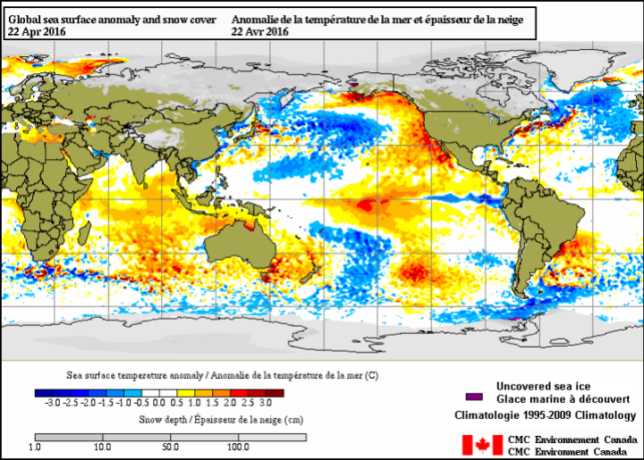
Figure 1 Source is here.
He adds:
The sea surface temperature anomalies for the easternmost NINO1+2 region have dropped well below zero (-0.6 deg C). Those in the NINO3 region have dropped to weak El Niño conditions and the NINO3.4 region continues to follow.

Joe Bastardi of Weatherbell notes:
Some sharp temp drops showing up in temps now as el nino rapidly backs off. Well forecasted spike, cooling starting

Now the forecasts.


Joe Bastardi of Weatherbell noted this about Figure 4 on Twitter:
Aug-Oct CFSV2 implications.High impact Hurricane season with atlantic warmth/la nina. Arctic coldest in many years
Arctic sea ice decline, if in fact driven by surface temperature, might not be as disastrous as is being predicted when the September melt peak comes around. But more worrisome will be the late Atlantic Hurricane season and water supplies for the west coast.
The Klotzbach/Gray hurricane forecast for 2016 states:
We anticipate that the 2016 Atlantic basin hurricane season will have approximately average activity. The current weakening El Niño is likely to transition to either neutral or La Niña conditions by the peak of the Atlantic hurricane season. While the tropical Atlantic is relatively warm, the far North Atlantic is quite cold, potentially indicative of a negative phase of the Atlantic Multi-Decadal Oscillation. We anticipate a near-average probability for major hurricanes making landfall along the United States coastline and in the Caribbean. As is the case with all hurricane seasons, coastal residents are reminded that it only takes one hurricane making landfall to make it an active season for them. They should prepare the same for every season, regardless of how much activity is predicted
La Niña conditions in the tropical Pacific mean a drier water year for the U.S. West Coast due to a blocking high pressure ridge:
![ENSO_pic[1]](https://wattsupwiththat.files.wordpress.com/2014/06/enso_pic1.jpg?resize=720%2C576)
California still hasn’t learned anything from the last water crisis, and still isn’t building any new water storage infrastructure. It may take a mega-drought before they finally decide survival of the state is more important than the greenies’ wailing objections to new reservoirs. It’s not a matter of if, but when.

Anthony I note Arctic sea ice blog has cryosphere data up for arctic and global sea ice extent day 118 and North and south hemisphere ice extents which look very dodgy but real. your site does not appear to be updating the way his is. Does he have access to an alternate source and why are you not being given this data?
Also the 3/4 El Nino estimate is stuck on 1.25 in your El Nino graphs and not updating but you and Bob seem to have the current data to discuss here. Why is BOM so slow to update?
This is a new “feature” of wordpress they foisted on me and millions of users. They cache images. Try CTRL + the refresh button on your browser.
What Anthony said plus …
There’s no indication of when the problem will be rectified.
Thanks for covering Joe Bastardi/Weatherbell. His Saturday summary from 4/30 was one of his best, where Joe emphasized the cyclical nature of the weather.
My family came to California during the Gold Rush. It was rather wet there back then so they settled in the LA basin to raise cattle. My granddad used to sit on the porch of his Victorian house in LA back in the 1950’s and he would complain about all the people there and say, ‘Go back east!’
Arizona was named Arizona and other relatives of mine settled in Tucson way back in 1880 and it has had several very dry spells and very wet spells since then some of which I remember very well, having grown up there and all that.
I remember when the U of A professors discovered the 200 year drought. When I was little, we used to pick up pottery all over the Tucson valley and around Kitt Peak and everywhere there were signs of abandoned farms from before 1300 when the Valley was much greener and wetter.
Then climate experts figured out there was this terrible long drought lasting 200 years and this caused the collapse and the poor farmers fled into the hills and built those magnificent ruins we see today.
All the plants and animals of the Southwest evolved rapidly during the present Interglacial. No longer do mastadons walk about Los Angeles to fall into the la Brea tar pits, for example. All the desert plants are recent evolutionary creations thanks to this 12,000 year drought. Ditto in spades for the Sahara Desert which was green during each Ice Age, too.
“Ditto in spades for the Sahara Desert which was green during each Ice Age, too”
Sorry but, no. The Sahara is dry during ice-ages and moist during interglacials. The current interglacial is rather weak and the wet interval in Sahara only lasted about 7000 years, returning to arid conditions with the “4.2 KA Event” about 4,200 years ago.
During the previous interglacial Sahara disappeared almost completely.
“Then climate experts figured out there was this terrible long drought lasting 200 years and this caused the collapse and the poor farmers fled into the hills and built those magnificent ruins we see today.”
Sorry, but no again. Mesa Verde and the other hill ruins were also abandoned during the Great Drought, about at the same time as e. g. Chaco Canyon and the hohokam ruins. The Hopi and the New Mexico pueblos were the only ones that survived.
““Ditto in spades for the Sahara Desert which was green during each Ice Age, too””
It is very interesting how often this claim is presented. However it appears Sahara is not really as stable as some warmists want to think, nor the heat of Sahara correlates positively with global temperature.
It appears to me totally plausible, that AGW increases precipitation in Sahara, making it greener, not drier.
“The Sahara is dry during ice-ages and moist during interglacials.”
Sorry, but no. The African humid periods are linked to precesional high northern insolation and therefore cycle every 23,000 years modified by eccentricity, as sapropels demonstrate. This one is even in Wikipedia:
https://en.wikipedia.org/wiki/North_African_climate_cycles
The Sahara will be green again in about 5000 years. If you want to get a head start go buy the land now that it is cheap.
“Sorry, but no. The African humid periods are linked to precesional high northern insolation and therefore cycle every 23,000 years modified by eccentricity, as sapropels demonstrate”
Sorry, but it isn’t quite that simple. You mustn’t believe everything you read in Wikipedia. It is true that the monsoon is modulated by precession, but the effect is vitiated during cold and dry glacial periods. If the 23 000 year cycle always applied there should have been at least three, and probably four, wet periods/sapropels between the current interglacial (sapropel S1) and the previous interglacial, but there is only one (S2) which occurred when precession happened to synchronize with the mild MIS 3 interstadial, and even that one is weak. The next older sapropel (S3) is from MIS 5e, c. 120,000 years ago. That time the precessional cycle coincided with the very warm Eeemian interglacial and resulted in a very strong sapropel, and mediterranean and at the same time african and mediterranean animals are found together in mixed faunas in Central Sahara, showing that no real desert barrier existed.
Incidentally those two moist intervals seem to coincide with Homo sapiens expanding from Africa. The first expansion during MIS 5e apparently ultimately failed and Homo sapiens was supplanted by Homo neanderthalensis in the Near East. The second one during MIS 3 succeeded.
tty:
You mustn’t believe everything you read in Wikipedia.
The eastern Mediterranean climate at times of sapropel formation: a review
Rohling, E. J., & Hilgen, F. J. (1991). Geologie en Mijnbouw, 70, 253-264.
“Sapropel formation in the eastern Mediterranean coincided closely with minima in the precession index. Such minima occur approximately every 21 000 years.”
From the conclusions:
“Orbital forcing of the climate seems to control the formation of sapropels in the eastern Mediterranean. More specifically, the cycle of precession appears to be dominant. Furthermore sapropels have been deposited both during interglacials and during glacials. Combined this suggests that increased seasonal and land-sea temperature contrasts are more important, for the climatic changes initiating sapropel formation, than average warm (interglacial) or cool (glacial) conditions.”
This was Rossignol-Strick 1985 monsoon hypothesis, that has been confirmed numerous times.
As precession is modulated by eccentricity, during low eccentricity periods like currently, sapropel formation is greatly diminished. That is the reason of the irregular dating of the most recent sapropels.
http://www.nature.com/ncomms/2015/151110/ncomms9751/images_article/ncomms9751-f2.jpg
Skonieczny, Charlotte, et al. “African humid periods triggered the reactivation of a large river system in Western Sahara.” Nature communications 6 (2015).
You are not only wrong, but insisting.
https://en.wikipedia.org/wiki/Sahara_pump_theory
You are correct about that theory…An example of the Saharan pump has occurred after the Last Glacial Maximum (LGM). During the Last Glacial Maximum the Sahara desert was more extensive than it is now with the extent of the tropical forests being greatly reduced.[8] During this period, the lower temperatures reduced the strength of the Hadley Cell whereby rising tropical air of the Inter-Tropical Convergence Zone (ITCZ) brings rain to the tropics, while dry descending air, at about 20 degrees north, flows back to the equator and brings desert conditions to this region. This phase is associated with high rates of wind-blown mineral dust, found in marine cores that come from the north tropical Atlantic.
Around 12,500 BC, the amount of dust in the cores in the Bølling/Allerød phase suddenly plummets and shows a period of much wetter conditions in the Sahara, indicating a Dansgaard-Oeschger (DO) event (a sudden warming followed by a slower cooling of the climate). The moister Saharan conditions had begun about 12,500 BC, with the extension of the ITCZ northward in the northern hemisphere summer, bringing moist wet conditions and a savanna climate to the Sahara, which (apart from a short dry spell associated with the Younger Dryas) peaked during the Holocene thermal maximum climatic phase at 4000 BC when mid-latitude temperatures seem to have been between 2 and 3 degrees warmer than in the recent past. Analysis of Nile River deposited sediments in the delta also shows this period had a higher proportion of sediments coming from the Blue Nile, suggesting higher rainfall also in the Ethiopian Highlands. This was caused principally by a stronger monsoonal circulation throughout the sub-tropical regions, affecting India, Arabia and the Sahara.[citation needed] Lake Victoria only recently became the source of the White Nile and dried out almost completely around 15 kya.[9]
The sudden subsequent movement of the ITCZ southwards with a Heinrich event (a sudden cooling followed by a slower warming), linked to changes with the El Niño-Southern Oscillation cycle, led to a rapid drying out of the Saharan and Arabian regions, which quickly became desert. This is linked to a marked decline in the scale of the Nile floods between 2700 and 2100 BC.[10]
And to finish: way, way back in 1950, smart people who lived for 100 years in California were warning about too many humans living in that state due to the lack of water especially the Los Angeles basin!
Arizona is even worse off but thanks to the Hoover Dam, they can get water from the Colorado river. Even so, the population in that state is too high for the water table, I remember clearly swimming in rivers in Scotsdale and Phoenix and Tucson that ran year round but now are totally dry today!
We even had a boat we kids took out to the rivers to go fishing way back in 1960. All gone now.
El Niño, Spanish for “the boy” refers to the Christ child.
Happy Easter to all those who may be celebrating it today.
Yes, and it was named by the Spaniards in Peru, because it usually happened around Christmas. They did not have a special word for “La Nina”, since it was considered the normal state, or rather did not differ greatly in effect from normal/neutral ENSO conditions.
El Nino on the other hand caused torrential and destructive rains in what is normally an extreme desert and ruined fishing, so it was definitely noticed.
It was the fishing that went bad. Tuna, etc. go elsewhere during el Nino years which causes great economic distress in Peru, etc. And then there is the huge change in rainfall, of course.
Sorry, but no again. There are no records of the use of “El Niño” to refer to the climatological and fishing conditions in Peru prior to the second half of the 19th century, and Peruvians cannot be referred as Spaniards since 1824.
Actually they were mostly known as “criollos” before 1824, but by Spaniard I meant “spanish-speaking”.
By the way the term was first mentioned by scientists in the late nineteenth century, peruvian fisherman quite likely didn’t invent the word just before that.
tty:
“Actually they were mostly known as “criollos” before 1824, but by Spaniard I meant “spanish-speaking”.
Still incorrect. “Criollo” was the term for people born and raised in the colonies from pure European descent. They were a minority of the population. Fishermen were most likely all “mestizos” (mixed-race) or “indios”.
Spaniards are people born in Spain, or from a Spanish parent elsewhere, or that have acquired Spanish nationality. Language has nothing to do and there has always been people in Spain that can barely speak Spanish, as it is only one of the languages of Spain.
As no use of “El Niño” referred to climatic or fishing conditions can be traced to before 1850, it cannot be assumed to be any older. Of course you are free to think that it dates from the introduction of Christianity in Peru. As keen observers of the environmental conditions on which their livelihood depended, I am sure a lot of people in he Pacific coast of the Americas were very aware of the repeatability of the ENSO phenomenon since humans have been living there.
California will have problems as long as the greens rule. Much of the water storage is going to the delta smelt, and other green causes, not agriculture. Of course, looking at the graph of paleo-climate droughts, the state is a bad bet in the long run.
It appears the NCEP forecast is for very warm water around Antarctica. The time period is in the middle of SH winter. Wouldn’t that area be covered in ice? How could it have warm SSTs?
That NCEP forecast looks dodgy to me, also.
On the NCEP CFSv2 forecasts for the fall 2016, the Southern Ocean’s depicted warm anomaly (deep reds around Antarctica) seems to me to be pure model fantasy.
Right now the Southern Ocean observations have mostly a cool anomaly values, and it’s headed to winter down there, with current sea ice values (probably but no data right now) at or slightly below historical. That implies big time heat loss as the ice vigorously forms in the cold nights air. That implies the Southern Ocean will be rapidly dumping to space the ElNino heat they receive, if any.
El Nino only produced average to above average rainfall in central and northern California. The south saw well below average rain again this winter. Snowfall was only average in the north and central but the snow pack has dropped precipitously since the peak, sitting at 64%, 69%, and 47% of the daily average on friday. I think it’s going to be another dry summer with La Nina coming on.
I would bet that No California is going to experience a cooler than normal summer this year. So far there has been decent rate through out this spring with 3 days of rain forecast for the middle of this week. I would bet that there will be an increase of summer rain events this year over last year. Last year each month of the summer had some rain, whereas there was zero rainfall in the previous 3 summers. This next winter should top off lake levels in No California.
With systems claiming water from all over the entire west, it would be wise to spilt California into 2 states so North California could price its water to South California. You’d probably see a great migration of people burning large amounts of cheap oil to go North to golf and wash their car.
I would love to see that happen, as long as Sacramento stays in the southern portion.
If it hadn’t been for Japan bombing Pearl Harbor, CA might have split up years ago.
The winter of 2010-2011 was a La Niña winter and I had 171% of the 10 year average rainfall here in the Sierra Nevada foothills of northern California. This year is almost complete and I have recorded 141% of the 10 year average rainfall.
El Niño conditions consistently give us above average rainfall but La Niñas are more of a mixed bag. We’ll just have to see what happens.
These reservoirs are also needed for hydropower buffering wind and solar…
I’m wondering what kind of weather pattern it would take to cause a 200-year-long drought in California. A 200-year-long persistent high pressure system over California?
Perhaps something along the lines of Jupiter’s “Great Red Spot” circulation pattern? Could Earth have had something similar in the past?
There is a some (not perfect) correlation between the Little Ice Age and that 200 year drought in CA.
Perhaps cooler weather moves the position of that blocking high?
http://www.cpc.ncep.noaa.gov/products/intraseasonal/tlon_heat.gif
http://www.cpc.ncep.noaa.gov/products/analysis_monitoring/enso_update/heat-last-year.gif
Click on the image to see the latest version.
California hasn’t had a mega-drought in the Southern half for half a millennium. These mega-droughts can last for several hundred years and this is why cacti of the SW desert evolved so rapidly in just 10,000 years.
There are way too many humans in California now. The population there was very small when the Spanish came in around 1600, decimated by the previous mega-drought. Even though humans had lived there since 20,000 years ago and they hunted mastodons there, too, there was no great civilizations there unlike say, central Mexico, Central America, Peru, etc. Very few people could eke a living out there in California, not even able to build small cities like in eastern Arizona, New Mexico, or the Mississippi valley.
I’m wondering why NCEP uses a projection which greatly exaggerates polar regions’ size. Is there any real scientific reason to use the linear latitude as the vertical axis?
As I’m living here as North as Greenland, I’m already used to at least four options
* My place is cut away as uninteresting (like in a German weather map)
* My place is presented in a distorted corner of the map
* My place is huge because latitudes are made as long as the equator
* The area is right, but shape not (this is often the best choice)
Hugs,
You *do* understand it is impossible to show the entire Earth without distortion…being an oblate spheroid and all. With you so far north, the best projection for you would be a Polar Stereographic projection (https://en.wikipedia.org/wiki/Stereographic_projection) where you are looking down at the pole.
The best projection from 0-30 lat is what you see above – CED (Cylindrical Equitorial Display) or Lat/Lon where the latitude/longitude are nice equal squares but greater distortion away from the equator & toward the poles . The best for 30-60 lat is the Lambert Conic Conformal with compressed distortion above 60 lat & stretched distortion below 30 lat. The best from 60-90 lat is the Polar Stereographic with greater stretching distortion below 60 lat.
There is no one-size-fits-all without sacrifice…sorry.
I know, but if you emphasize the size of the polar regions, you create completely bogus overall picture on the temperature around the world.
So projections with equal area are IMO best here.
Drought resistant plants didn’t evolve for nothing in California.
It is easy to say that California needs more dams. However it is a lot harder to figure where to put them. California currently has 1400 dams and has diverted all of the water from 2 of the states larges natural lakes (Owens lake) and lake Tular). Ownes lake is now dry and lake Tulare doesn’t appear on any map. I have not found any state with anything close to this number of dames .
To build a dam you need a location with suitable geology and enough water flow and storage capacity to make it practical. Geologist and engineer have searched all over California and have identified 5 sites. If all 5 were built they would provide only 1% of California’s average use. That is not enough storage to make a big difference or justify the expenditure of an enormousness amount of money needed to build them. The greens are not stopping new dam building. Economics is stopping the construction. The simple fact is that after 80 years of dam building there are no good building sites left.
The only place where you could build a dam large enough to store enough water is Carquinez strait near San Francisco. however building it would flood the cities of Redding, Sacramento, Fresno, and Bakersfield. About 6.5 million people and most of Californians farms are located there. The lake would be 450 miles long, and about 60 miles wide and about 100 feet deep. The lake would likely loose more water to evaporation then it would capture from rain fall.
i’m good with the idea of flooding Sacramento…
just make sure the Legislature, Moonbeam, Kamala Harris and all the other idiots are in town when you do.
bonus points if you can catch Fineswine, Boxershorts & Pelousy too. 😉
There could be some severe stress placed on the coastal fault systems, under that scenario. The northern end of the Hayward Fault, which runs close to and to the west of the Carquinez Straits, would be very susceptible to the change in pressure.
Redding is 564′ above sea level, so it would not be flooded. Shasta Dam could be raised. Your Carquinez Strait dam is strictly a fairy tale and a straw man in the fight against dams.
That’s way off topic but still good to know for all those single guys out there.
Australian BOM still have a strong El Nino on the SOI
http://www.bom.gov.au/climate/enso/#tabs=SOI
Sounds to me like there will be opportunities for construction of new reservoir dams while the dry spell is on again. Think of the opportunities for hydro power, not to mention flood control…
So unfortunate that our money gets spent paying spin doctors to tell us it’s “getting worse” instead.
If cal covered the full mountain range with about 100,000 wind mill generators and built a heap of desalt plants, at the cost of about a trillion dollars you can have water for nothing.
Money for nothing and the chicks for free
As a long time California resident and weather watcher I am predicting above average precipitation for central and northern Cali. Small low-pressure systems build in the 20’s and spin up into the 30’s and drop their moisture in the coastal mountains and the Sierras. That’s “average”. I expect a return to “average” except colder than normal and lots of rain.
the “strong El Nino” of this past winter never made it to Lost Angels… we got maybe 9″ rain in my part of The Valley, like totally.
it was El Nopeo here.
The trend l pointed out earlier in the year of areas of high extending north/south has now really taken hold and looks like it will extend into May. This will increase the amount of Omega type blocking over the month. The Atlantic is looking like a prime area where this type of blocking will turn up. So am expecting NW europe to be rather cool and unsettled over May. Over in the North Pacific is a other prime
area for this sort of blocking. So still am expecting the high pressure ridging into NW North America will remain a common weather pattern through out May. Which will try to push cold air down across NE America. On May 8th/9th its looking like the NE tip of the USA risks been hit with late season snow. But with a increase likely of high pressure building over the USA l don’t think the cold will extend as far south as in April. But a increase in low pressure is likely over SW USA which should bring some cooler temps and some welcome rain to that area. With this trend of high pressure ridging northwards still in place. Am expecting the cooling in the NH to last through out May.
HadCET goes negative anomaly
https://sunshinehours.net/2016/05/01/hadcet-apr-2016-mean-temperature-tied-for-217th-warmest-out-of-358/
Our Tornado Alley storm season seems to be a little weak so far this year. The first good opportunity we got this year was last week, but all that storm front could generate were weak F1 tornadoes, and very few of them. The jet stream was not lined up properly to enhance the strength of the storms last week.
Perhaps we are having a continuation of the low number of tornadoes we have been experiencing over the last decade or so, even in this El Nino year.
The weather trends/jet streams already seem to be working their way north which should allow high pressure to build in the central part of the U.S.
May’s weather will be interesting. Will the severe weather pick up, or will it be milder like April?
None of this precludes a very hot summer, which is possible just about any summer, depending only on how long the high pressure system hangs around.
Glad to hear that some parts of CA received above normal rainfall. I live in San Luis Obispo, CA and we received below average rainfall. Even though we would have to move (and it would kill me to leave all of my fruit trees) if the drought continues I do not want to see more reservoirs built. More reservoirs means more people and the destruction of more wildlife habitat.
One of the great impediments to modern life is the plethora of Greenies sitting on their butts, howling about and railing against people building dams and nuclear power stations. If they could be released from their groundless delusions, they could return to the advance of civilisation.
large negative AO for last month. Does this mean any freezing recently in North East USA?
If the reservoirs are full, by definition the drought is over. Anticipating a future drought does not mean we have a drought now.
Historically, strong El Ninos are followed by colder than normal La Ninas, so we should have a cold and dry winter this year, at least for the US West Coast…
I feel sorry for my California friends that will likely suffer through below normal precipitation levels this winter because of the coming cold La Nina.
California must spend massive amounts of money to build more reservoirs and should also build desalinization plants in Los Angles and San Diago to meet the water needs of a growing population..
California must also immediately stop wasting billions of gallons of water by needless dumping water into rivers to “Save the River Smelt!”, and hold the water in reserve to “Save the Farmers” and “Save Californians”…. but alas…. California is run by Leftist lunatics that are incapable of logical thought.
Of course Californian Leftists loons will blame the coming California drought on CAGW, rather than correctly attributing it to the coming colder than normal La Nina…
BTW, the new weekly Nino3.4 SST Index came out today: fell 0.21C in one week (from 1.02C to 0.81S) … Oh, my…:
http://www.bom.gov.au/climate/enso/monitoring/nino3_4.png
BTW, you have to click on the above graph to get current NINO3.4 numbers….
I don’t know why….
We also need to stop wasting water growing alfalfa and the like. Irrigation should be reserved for high nutrition crops that can be eaten by Americans.
ahem.
alfalfa feeds cows, which results in tri-tip roasts, which are an essential part of the #Failifornia diet.
what we need to do is stop wasting water on kale, arugula, and other foodie garbage so beloved of the delusional tourists who moved here from back east and ruined Paradise.
Tri tip from range fed steers is the only way to go.
This is looking really bad. It is going to be our harsh reality until PDO flips warm (and by that I don’t mean the sort of “fake out” minor flip we saw a couple years ago, I mean flips and stays warm for ten or more years).