
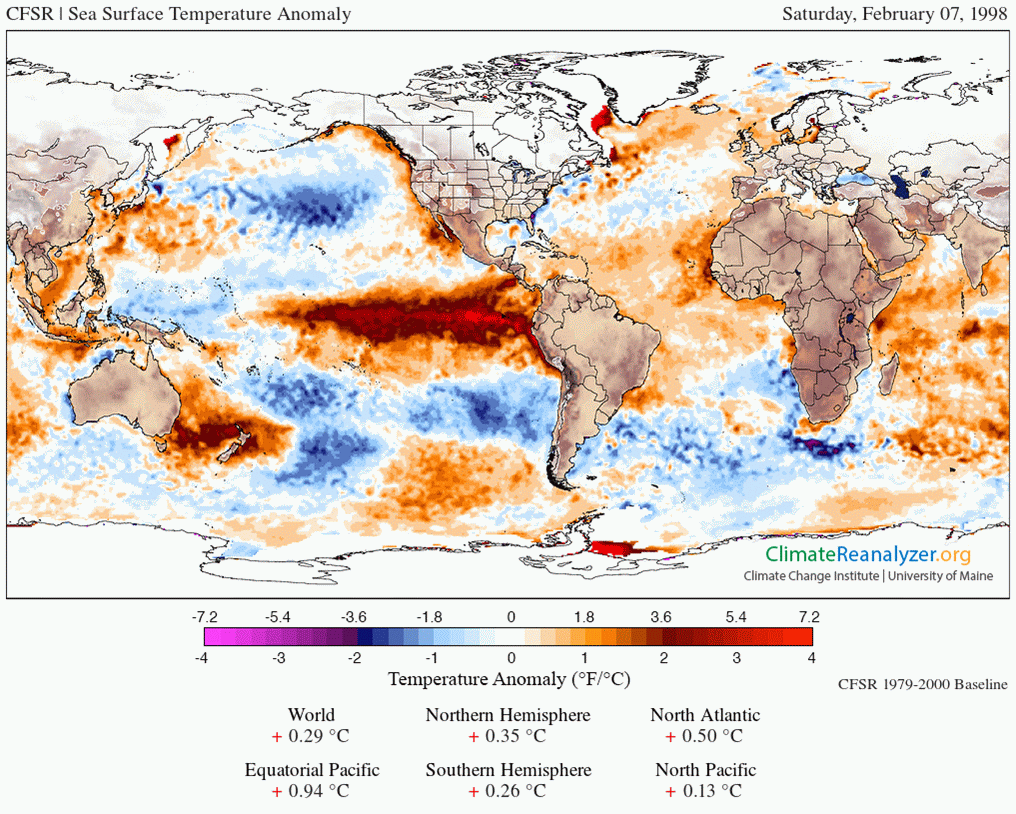
Change in sea surface temperature anomalies in the last month; courtesy NOAA
This naturally occurring oceanic cycle that produces warmer-than-normal sea surface temperatures (SSTs) in the equatorial region of the Pacific Ocean began in earnest early in 2015 and strengthened throughout the year to comparable intensity levels of the strong El Nino episodes of 1982-1983 and 1997-1998 although the warmest region relative-to-normal set up in somewhat different locations. El Nino has had widespread consequences around the world and will continue to do so in the near future. By later this year, colder-than-normal sea surface temperatures are quite likely to appear in the tropical Pacific Ocean as predicted by multiple computer forecast models and this flip to La Nina will also have extensive consequences around the world.
Rapidly changing SST anomalies
The latest sea surface temperature anomalies show noticeable changes from just one month ago across the tropical Pacific Ocean (above). Specifically, while the sea surface temperatures in that region are still above-normal, they are noticeably less so than just four weeks ago. This trend should continue over the next few months as sea surface temperatures drop off rapidly in the equatorial region of the Pacific Ocean.
– See more at: http://www.thegwpf.com/the-collapse-of-el-nino-is-underway/#sthash.ms5DlDgW.dpuf

The collapse of El Nino in the tropical Pacific Ocean has begun and it will be rather dramatic. The current strong El Nino event reached its peak intensity level in December 2015 and all indications suggest it will completely flip to La Nina conditions by later this year. One of the important consequences of the current strong El Nino event in the equatorial Pacific Ocean was a spike in global temperatures. However, if recent history is any guide, expect global temperatures to drop sharply after La Nina conditions become well-established in the tropical Pacific Ocean – likely during 2017 and perhaps beyond. –Paul Dorian, Vencore Weather, 5 February 2016
source: TheGWPF
UPDATED to include missing content that didn’t get sent in the first posting, due to a weak Internet connection during my flight,
I was enjoying the rain and mild winter weather.
Recall that 2010-2011 was a La Niña winter, and the Sierra Nevada got an extremely heavy snow pack, much of it arriving late in a “March Miracle” plus April as well. Squaw Valley USA recorded over 800 inches of total snowfall that season. On 1 May 2011, the western snow pack was incredible:
http://wattsupwiththat.com/2011/05/18/western-snow-pack-is-well-above-normal-squaw-valley-sets-new-all-time-snow-record/#more-40175
FWIW here’s the current “Snow Water Equivalent % Normal” map today, showing most of the west above normal to date:
http://www.wcc.nrcs.usda.gov/ftpref/data/water/wcs/gis/maps/west_swepctnormal_update.pdf
And caused heavy flooding along the Missouri river.
Still a model prediction.
Lets see what happens.
modelling is dead, mitigate or perish.
http://www.abc.net.au/news/2016-02-11/csiro-boss-larry-marshall-defends-controversial-shake-up/7157650
Not just models. Historically, a strong El Nino event is followed by La Nina. In fact, they are usually 2-3 year events.
I would not expect the fall to be any sharper than the recent rise which was building since 2011. This is not a sharp peak like 1998.
The idea that this El Nino was on a similar scale is rediculous, it was a small gradual peak on a warmer baseline. It happened around SSN peak. 1997/1998 was near the trough.
Perigee full moon is still quite close to the equinox this year. Maximum tidal forces still focussed on the equatorial region.
This is a point that people often overlook; how have temperatures risen above the current prevailing base line (not the 30 year base which is usually plotted)? The super El Nino of 1997/8 came from a far lower base line than this current El Nino. But of course, that may not be the only distinction.
According to the satellite data sets, there was a step change in temperature of around 0.27degC coincident with the 1997/8 Super El Nino. if there is no similar step change coincident with the current 2015/16 strong El Nino, the current strong El Nino when history comes to be written will be a damp squid, and it is likely that all we will see is a short lived peak, such as was seen with the 2010 El Nino, and the La Nina that follows in late 2016/17 will bring temperatures right back down again. And IF they then stabilise at around the 2001 to 2003 anomaly level, the ‘pause’ will lengthen and run to over 21 years when AR6 is being written/published in late 2018/early 2019.
It is quite conceivable that things could be very difficult for AR6, but of course, we will have to wait and see what the coming few years deliver.
A single square wave becomes an upward step change when the trailing decline (cooling) is truncated. That interpretation sees the 97-98 step change then not so much as a strength of the uptick (El Nino releasing warmth), but as a failure of the following LaNina to reset temps back to the prior baseline. The 99-01 LaNina coincided with SC23 maximum.
The coming 2017 LaNina will coincide with an SC24 closeout with TSI and F10.7 values approaching intercycle minimums.
A downward step change anyone?
It’s “damp squib”, but you’re not alone: http://www.telegraph.co.uk/news/uknews/4799157/Damp-Squid-The-top-10-misquoted-phrases-in-Britain.html
A statistical removal of ENSO and volcanic effects shows the step up actually occurred in 1993.
http://www.nature.com/ngeo/journal/v7/n3/images/ngeo2098-f1.jpg
Could it be the noise from these activities just made us think the change occurred in 2001? 1993 is also when the stratospheric cooling occurred as a result of the Pinatubo eruption. It seems more likely the warming is a reaction to that cooling and since nothing like that is happening now there is little chance of a step up (or down). Just continued slow cooling.
Richard M,
The leading edge of the step-up may have been earlier than the 97-98 EN. My conjecture returns untouched though. The relaxation of a system to its baseline is determined by the forcing present at the trailing edge of a square wave function, i.e. The coincidence of the SC23 max stll may have truncated a fuller LN cooling event at the turn of the century.
Keep in mind the prevailing tropical Pacific weather patterns associated with each event. LN events present cooler waters and suppressed convection, allowing SW radiation to more effectively warm the upwelling E Pac waters. These convection and SW-albedo interactions/feedbacks are better addressed by Willis E. With the work and developed ideas he has presented here on his WUWT posts.
I would imagine that most squids would prefer to be damp. At the very least. 🙂
Richard M. May I ask, what is the source of your graphs?
Interestingly, the source of the graph is a paper by Santer et al. It was a paper attempting to create an excuse for the pause.
http://www.nature.com/ngeo/journal/v7/n3/full/ngeo2098.html
Joel says, “A downward step change anyone?”
====================================================
I admit it is wishful thinking on my part, yet there may be good reasons to think it possible or even likely. The cause of the step up is certainly worthy of consideration. During and preceeding the “step up” had strong solar, the El Nino, and an strong nearing peak AMO. The AMO is turning down, solar is now going weak, and if we also have a strong La Nina ad the blob dissipates, then a step down may be more then wishful thinking.
correction, ” and if the blob dissipates”
(Which by the way appears to be happening, although the last two weeks we have had a high pressure ridge settle off the North West pacific, again cutting off Calif from Pacific storms. Living here I hope that goes away soon)
The difference between this El-Nino and the 98 El-Nino is that the waters North of the standard Nino boxes was considerably warmer than normal for the past 2 years and probably had as much to do with warmer global temperatures than the El-Nino itself. The warm blob in the Northern Pacific has already collapsed and both the Northern Pacific and Northern Atlantic are already showing noticeably cooler surface temperatures. It would appear that globally the oceans are finished belching heat for a while and I would expect a sharp decline in global temps by the end of this year.
http://www.ospo.noaa.gov/data/sst/anomaly/2016/anomnight.2.8.2016.gif
But, that effect could be because the ’98 El Nino was still being supported by the positive phase of the ~60 year oscillation, whereas this one is fighting against the negative phase. I would not be surprised at all to see it fall off an abrupt cliff.
And we start to have comprehension of what caused the SW Megadroughts last millennium. Beyond PDO there must be even lower frequency oscillations which can stamp out any positive impacts of ENSO for decades to centuries.
indeed ,so many people just do not look at the big picture though. been way too much focus on magic gas.
indeed, just a pity there has been so much focus on magic gas instead of the big picture.
Strong El Niños usually peak in December, but don’t fizzle out completely until mid summer. Note the similarity of the current El Niño to ’65-’66, ’72-’73, ’82-’83, and ’97-’98:
http://ggweather.com/enso/oni.jpg
Based on that history, my very-non-expert guess is that the last few months of 2016 and all of 2017 will be spent in La Niña territory.
Reblogged this on Public Secrets and commented:
I had a feeling the current El Nino was turning out to be an “El Wimpo.” Still, we received some pretty good snowfalls in the Sierras, which is what California really needs, so here’s hoping this is the start of a growing trend.
Kiss the pause good bye, here comes global cooling.
Doesn’t that just lengthen the Pause?
It depends by how much cooling is seen.
Initially, cooling will result in lengthening the ‘pause’ (working in both directions). but once the step change in temperatures that is seen coincident with the 1997/8 Super El Nino has been cancelled out, one will begin to see a cooling trend not just over the last say 20 years, but rather over the entire period of the satellite data set. However, there has to be quite a drop in temperature before that will be seen.
But heck, who knows, other than it is foreseeable that there will be pressure in some quarters to make the required homogenisation/adjustments etc to deal with that inconvenient ‘fact’.
that all will depend on the AMO, which is actually just over it’s peak and starts it’s drop. If the PDO will switch back to positive in time it will for short cancel out the AMO but that means that 20-30 years later a new PDO- will fall on the peak of the negative AMO….
paired with a weak sunspot cycle this can for sure mean global cooling of a few tenths of a degree C
But don’t we have CO2 well above the end is near level ?
Not likely, there will be further adjustments to eliminate any drop in temperature
I wish there was some way to adjust my tomatoes so they’d ripen even as the temps decline. /sarc
And therefore an even greater gap between surface temps and the satellite lower troposphere temps.
Agreed, it’ll be hottest in those parts of the globe that nobody lives in.
It will be even hotter in those parts of the globe without ground based sensors.
Calling it by a more accurate term, “STOP” makes it easier to talk about. The stop in warming will very likely continue.
(and, likely will become a cooling trend — still, “stop” in warming covers it 🙂 )
I’m with you Janice, STOP is the correct term
I often use plateau.
“The stop in warming will very likely continue.”
What would happen if the stop stopped?
Nick Stokes,
Then the stop in global warming would be stopped; it would either resume its natural recovery from the LIA, or global T would begin to fall.
I suspect the first would thrill you, sending a tingle down your leg, and the second would cause you to emit endless contrived explanations…
We don’t know, do we? So where policy? We don’t know, do we?
=================
At the cessation of a gently sloping plateau we come to an escarpment and with no positive feedbacks in sight.
How unconvenient that is. The 1998 el nino spike, was followed immediately by a clunk that about restored the local average, and then tended to decrease more or less since.
Maybe M of B needs to sharpen his pencil to get the pause back on track to expandification.
G
The 97/98 spike was a spike, this time more gradual and much less amplitude.
@Mike,
the 2006 was gradual as well, and returned to “normal” afterwards.
Anthony’s plot on the ENSO page (see: http://www.bom.gov.au/climate/enso/monitoring/nino3_4.png) shows that this El-Nino started out in 2014 (where the ramp crosses SST axis 0).
The plot of Nino 3-4 since about 1950 puts this one in perspective. (http://www1.ncdc.noaa.gov/pub/data/cmb/teleconnections/eln-f-pg.gif)
It’s pretty much the same as all the other big spikes on the graph… maybe a scosh taller.
A little early to call.
Time will tell.
I’d say, integration of the area would be more informative than maxima, minima.
Yes, and at a time when the AMO is falling.
Oh blow! I was quite enjoying the mild winter, although it has been a trifle damp and overcast. You now the English Summer will be somewhat cool. I though global warming was meant to cause more extreme variability in climate not less!
It’s extreme how little variation there is. Panic!
/sarc
No real data in this post to support “collapse underway”. And the cited Vencore really only has models predicting June and beyond for 2016.
Oh yes there is.
Publication of trade wind data coupled with this information would be interesting.
Here’s some data from a northern California perspective provided by the Cal Water Resources Dept :
http://cdec.water.ca.gov/cgi-progs/products/PLOT_ESI.pdf
Updated daily. With useful comparisons to prior large impacting El Ninos
Really? What about the figure at the head of the post? You may have to make use of the Mark I eyeball to “integrate” the information, but it seems sufficient to convey the result as presented.
“Really? What about the figure at the head of the post?”
You could drag your insightful eyeball to the bottom of that post, and read the update. When I wrote my comment, the post started at the heading
“Rapidly changing SST anomalies”.
Fine then. Would you care to restate or withdraw your objection now that new information is available?
Here’s how the NOAA Multivariate ENSO Index compares with the 1997-98 El Niño: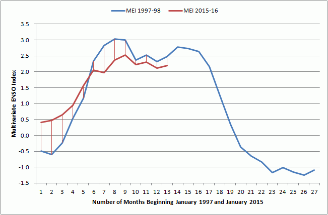
More here if interested:
https://oz4caster.wordpress.com/2016/02/07/el-nino-comparison-1997-98-versus-2015-16/
I have not done an SST anomaly comparison since Feb 7:
But here is today’s SST anomaly map from the same UM CCI source for comparison to above:
http://pamola.um.maine.edu/fcst_frames/GFS-025deg/DailySummary/GFS-025deg_WORLD-CED2_SST_anom.jpg
similarity between 96 and 16 are striking.
Ouch. That can’t be good for Climatist’s job security. Maybe they can spin it as “more heat is hiding in the ocean depths”.
lol… or…
“At the higher latitudes…” or “In the stratosphere…..” or “In my brother’s cherry pie….” or whateverrrrrrrrrrrr. lolololol
In one of Bob Tisdale’s articles here I asked if the seemingly constrained volume of this warm water as it appeared late last year, could be used to estimate how much warming could persist. It seemed to me that there wasn’t enough ‘hot water’ to heat the globe for too long. Does anybody attempt this evidently simple calculation at least for a maximum to be expected in terms of months.
gravitational waves found
http://www.bbc.co.uk/news/science-environment-35533241
‘found’? vukcevic
Announcement on the project not until later in the week-
Or have you already ‘heard’? A positive announcement is sure going to be interesting.
I’m thinking with the desperation of science these days to make significant discoveries and a decided decline in ethics and even honesty, I’m going to remain sceptical of a discovery of gravity waves until the report is fully audited.
The Higgs boson was one such ‘sort of, yes but may be not discoveries. It seemed to be hurried out there because Higgs himself was close to the end of his life. Nice gesture perhaps, of a Rotary Club type, but a no no for serious science which we haven’t seen much of this century and for sometime before.
Climate science’s undisguised dishonesty and worse, the silence of most other scientists on this issue, bespeaks of the prudence of distrusting all such claims as a default position. Used car salesmen have a major job ahead to reestablish their reputations as they’ve slipped below scientists in the dishonesty ratings. I don’t believe they have discovered gravity waves.
Have we concluded the source of El Niño’s? Any guesses… Is it Volcanic activity on the ocean floor?
Mark,
I would suggest you do this:
1. Type “Bob Tisdale” into the WUWT search box (upper right margin of this page) and read his numerous posts about ENSO. OR
2. Buy his e books (available at Amazon and via bobtisdale.wordpress.com ).
Sample from e book by Tisdale, “Climate Models Fail”
Your friendly librarian,
Janice
So when El Ninos are caused by Bob Tisdale 🙂 who causes interglacials to end?
(I have no idea how you can measure the amount of radioactive material inside the Earth. Of course there are ways to estimate it, but I’m kind of suspicious how precise they can be. And of course, a model which is based on unchanging or uniform energy flow through the sea bed might not be that good.)
(Oh yeah, by uttering this I can be canned as a den ialist)
Heh, I find no fault with Bob’s style.
====
Based on the decline in solar heating of the tropics, I had predicted that this El Nino would not as powerful as 1998 due to a smaller volume of heated water. The drop in solar insolation would also predict a drop in the trade winds. Thus I would now predict that with weaker trade winds, we should expect a weaker La NIna will follow.
Assuming solar insolation remains low, I would also predict a decrease in the east-west Pacific temperature gradient, a drop in the global average temperature and a lack of warming in the upper 700 meters of the oceans. Lower irradiance during the Little Ice Age was associated with a reduced east west Pacifc temperature gradient and I would expect the same.
I agree, Jim. The question is: What are we going to do with all our extra time and money when this ‘global warming’ paradigm is finally laid to rest?
Leonard Nimoy knows:
“The Coming Ice Age”
(youtube)
Brought to you by………
Enviroprofiteers, Inc. — Bilking the public, one sc@m at a time.
“Stop using HFC’s, now!
It couldScientists say it will cause another ice age!!! Buy our banana leaf hand-powered air conditioning unit (for bigger jobs, try our bicycle-powered, Hefty Hansen!).”And WUWT will continue the perennial battle for science realism.
Shovel snow. Then, the rest of the year, save money for next Winter, to hire some kid to shovel snow.
Here is a transcript I prepared from the video.
LEONARD NIMOY: In 1977 the worst winter in a century struck the United States.
Arctic cold ripped the Midwest for weeks on end.
Lake (late?) blizzards paralyzed cities of the Northeast.
One desperate night in Buffalo eight people froze to death in marooned cars.
Pat Bushnell was on the road that night.
PAT BUSHNELL: Traffic just absolutely stopped.
I was afraid of being stuck in the car all night long with the cold and the wind, running out of gas.
And then what?
I think if we had to go through a real bad winter, just like we just went through, I think we’d have to think about moving someplace else.
LEONARD NIMOY: Move where?
The brutal Buffalo winter might become common all over the United States.
Climate experts believe the next Ice Age is on its way.
According to recent evidence, it could come sooner than anyone expected.
At weather stations in the far North temperatures have been dropping for 30 years.
Sea coasts long free of summer ice are now blocked year round.
According to some climatologists within a lifetime we might be living in the next Ice Age.
Wow, it seems like they’re using the same script and have simply switched the references of cold with references of heat.
Here is how it would read now:
BILL NYE: In 1998 the worst summer in a century struck the United States.
Massive heat waves ripped the Midwest and Great Plains for weeks on end.
Triple digit temperatures paralyzed cities in the Southwest and California.
One desperate night in Tupelo [MS] eight people sweat to death in over-heated cars.
Cooter Bushwacker was on the road that night.
COOTER BUSHWACKER: Traffic just absolutely stopped. Gallons of antifreeze flowed down the storm drains because of all the busted radiator hoses.
I was afraid of being stuck in the car all night long with the humidity and the mosquitos, running out of beer.
And then what?
I think if we had to go through a real bad summer, just like we just went through, I think we’d have to think about moving someplace else.
BILL NYE: Move where?
The brutal Tupelo summer might become common all over the United States.
Climate experts believe that a Climate Catastrophe is on its way.
According to recent evidence, it could come sooner than anyone expected.
At weather stations in the far North temperatures have been rising for 30 years.
Sea coasts once blocked with winter ice are now open year round.
According to some climatologists within a lifetime we might destroy the entire world.
Oh, Freedom Monger — (((APPLAUSE!))) — THAT WAS EXCELLENT! LOLOL “Cooter Bushwhacker” – lol. (reminded me of that document purloiner, Scooter Libby – is that his REAL name?? Pitiful.)
Thanks for making me laugh 🙂 .
Janice
er, perhaps you mean Sandy Berger, AKA Sandy Burglar. He’s now deceased so we may never know, but he probably purloined damning handwritten notes in the margins of high level Clinton Administration paper about Bin Laden.
The innocent Scooter Libby was railroaded by an out of control prosecutor, Patrick Fitzgerald, and a complicit media enjoying the show. The one juror at his trial who understood what was going on was removed and the lead juror was a WaPo reporter, or columnist, fergit now which.
The FBI on morning
Lost its notes suborning;
Eckenrode,
Where is that toad?
He’s wanted at a harrowing.
==============
Dang, that’s supposed to be ‘The FBI one morning’. Look it up. They lost Agent Eckenrode’s notes in order to pin perjury on Libby, by suborning perjury from the reporter Tim Russert.
===============
Jim Clarke: We’ll likely chop alotta wood, until coal mining can recover from the only War this admin fights.
We might also get a double whammy considering that the cosmic radiation is increasing, most likely due to decrease in solar activity
http://news.spaceweather.com/cosmic-rays-are-intensifying/
Jim, suspect you are right but defer ENSO judgement to Resident expert Bob Tisdale. There are a number of other indicators beyond the disputed solar cycle. Cyclic Arctic ice recovery underway. Stadium wave. The last global ‘cooling’ ran from about ~1950 to ~1975, so if there is a natural oscillation we are about half way through its down phase. And so on.
It is collapsing almost as fast as Obama’s illegal Clean Energy Act.
EPA Clean Power Plan unconstitutional regulations. OBummer tried but failed to get carbon taxes through a Congress his side then controlled. No hope of getting a Clean Energy Act through a Congress he no longer does. Hence his attempted (via EPA) constitutional end run.
The Supreme court just shot it down.
Hybris, nemesis, old story.
=============
http://video.foxnews.com/v/4748755236001/napolitano-supreme-court-epa-ruling-a-first-in-us-history/?intcmp=hpvid1#sp=show-clips
Starting last fall I evaluated various El Nino regions with a cyclic analysis technique. My starting point in the evaluation was the Optimal Fourier Transform developed by Dr. Evans It is in his spreadsheet which you can find here,
http://sciencespeak.com/climate-nd-solar.html
Getting the output from the OFT I use it as inputs to a canned program I have that goes through a Marquardt procedure to minimize the sum of the squares error (SSE).
I have evaluated regions 1.2, 3.0 and 3.4 using this procedure and I have found a very good fit to the measured data. In each of these cases I have extended the analysis out a short period of time to see what might be forthcoming.
I have a separate function definition sheet where I input the presumed fitting equations. The sheet looks like this.
pk=length(‘b0)
kp=pk-1
kk=kp/3
e=1
for j=1 to kk
e=’H[j]
for i=1 to n
‘aaa[j][i]=b[e]*sin(2*pi()*b[e+1]*x[i]+b[e+2])
next i
next j
for i = 1 to n
T = 0
for j = 1 to kk
T = T + ‘aaa[j][i]
next j
y[i]=T+b[pk]
next i
I am fitting the data with sine waves as you can see. At the bottom I add a DC offset to the sine waves.
I used 90 sine waves to model the event so the total number of initial guesses I make are 3 x 90 +1 for the DC offset. I have pretty good initial guesses from the OFT.
My evaluation of El Nino region 3.4 can be found here.
https://onedrive.live.com/redir?resid=A14244340288E543!12713&authkey=!AH5OJG2X-u0IR1Q&ithint=folder%2c
I consider the fit to be excellent. You will note that I computed a separate correlation coefficient for dates later than the one indicated. That shows up in the table. I did this because the early data was quite noisy. You will also note that I transitioned to daily data sometime last year. One of the figures is a projection and to me it looks like a camel hump is in our future.
I go to Joe Bastardi’s weekly forecast every Saturday and I know that in one of them he said we are headed toward a La Nina. However, one of the figures he used in the presentation (Region 1.2) looked like a camel hump was a possibility.
Some of the evaluations in all the charts are suggestive of the possibility of a camel hump.
https://onedrive.live.com/redir?resid=A14244340288E543!12714&authkey=!AJcFhmrzYILDRPE&ithint=folder%2c
We shall see. I hope I did the right.
This is horrible news. Although mitigated, the drought is not broken. Once we are ENSO negative we’ll be back to drawing down stored water and aquifers in short order.
The heaviest rains in the PNW are mainly during negative ENSO conditions. I expect to see a flood event on the PNW at the end of this year, or if not in 2016/17 then the winter of 2017/18 should bring a flood event.
Whether El Nino collapse or gradual dissipation with a few spikes along the way, the weakening of the GAGW hypothesis continues on steadily.
John
The Nino 3.4 Index is still relatively high at +2.6C because all of the warm water at the equator is in the Nino 3.4 area while sea surface temperatures have fallen off in the other regions. Weekly Nino region values.
http://www.cpc.ncep.noaa.gov/data/indices/wksst8110.for
A few animations below to show what is coming up next year. First the equatorial cross-section (Pacific is in the middle). A huge amount of cold water is at depth in the Western Pacific. This cold water is now in the Equatorial under-current and will make its way to the Galapagos Island in about 6 months.
Think of the equatorial pacific as a giant loop. At the surface, the ocean is being dragged along by the Trade Winds to the West. When it reaches Indonesia, it has to go somewhere and very much of it is simply forced down at the continental shelf. It is forced down to 150 metres depth. And then at 150 metres depth, it starts to flow in the opposite direction now toward the East. One giant loop. Surface West, Equatorial Under-Current East. This cold water here is really the La Nina of 2013. Its still there. It is just now 150 metres down.
The cold water should eventually migrate east and cause a La Nina.
http://www.cpc.ncep.noaa.gov/products/GODAS/pent_gif/xz/movie.temp.0n.gif
But you need to look around a little further when it comes to the Giant loop. The next animation is looking top down to see how much cold or warm water there is in the top 300 metres of the oceans. There is still a ton of warm water sticking around in the Eastern Pacific around the equator. All the cold water circulating underneath in the equatorial under-current will have to push its way through this warm water hanging around at 10N and 10S in the East.
Which will win out is the question. In 2014, the developing El Nino petered out because of all the cold water left over from the previous La Nina’s in these exact same regions I imagine something similar will happen this year. The developing La Nina of 2016 will get moderated and not much will happen. This is the “missing” piece in ENSO forecasting.
http://www.cpc.ncep.noaa.gov/products/GODAS/pent_gif/xy/movie.h300.gif
So let’s see if the “scientist/modellers” cite 2016 as “the highest global temperature EVA!!” by the end of February
Hey I’m a mathematician who follows weather data for a hobby, specifically SST anomalies, and there is something in noaa’s sst data that I cannot understand that hopefully some of you more knowledgeable in this field can help me with.
Compare Noaa’s sst anomaly Full Global images from 1/28/2015 to the 2/1/2015, 3 days apart.
I don’t understand how dense pockets of above/below average anomalies especially at the poles could just smooth out that quick without any signatures of mixing.
Also the above/below regions in the 1/28 image seem to vary too continuously (like they are modeled) when you compare it to the same regions in the 2/1 image.
for example if you look at the full global 1/28 image, the cool region in the bottom left hand side (the boxed (40,80)x(-60,-40) regions) varies quite smoothly within itself.
But then in the 2/1 image, the same region is more pixelated and chaotic which is to be expected with real life data.
Any explanation would be appreciated(including someone informing me that it is not that strange).
“anomalies especially at the poles could just smooth out that quick without any signatures of mixing”
There is a steep vertical temperature gradient near the surface, so an increase in vertical mixing, from a storm say, could do that.
There is also fairly rapid surface advection with currents, and that looks a lot more near the poles. There are daily spherical plots of daily SST data here. They are direct AVHRR data. There are animated versions here. You can see some of the current motions there.
Nick @ his best. C’mon, you can do it!
============
This is mighty fine barrel racing and I hoot and holler.
==============
i like that nick,you are a man of many talents !
wind,rain,hail and snow
CFS shows no sign of a La Nina later this year. We could even go into another El Nino..
http://www.cpc.ncep.noaa.gov/products/CFSv2/imagesInd3/nino34Mon.gif
Indeed, earlier I posted a comment where my cyclic evaluation of region 3.4 is indicating a camel hump. BTW take a look at the NOAA chart for region 1.2.
Well we already, with the current El Nino, have a Dromedary Camel. I supposed you are suggesting the possibilitie of a Bactrian two hump Camel.
As Inspector Clouseau might say, “I knew that.” Since I started analyzing the NINO regions I have seen the hump in all of them. Joe Bastardi used this in one of his weekly forecasts. Thanks for reminding me on the camel distinctions.
https://onedrive.live.com/redir?resid=A14244340288E543!12710&authkey=!AF9Dl-pMET35Hu4&v=3&ithint=photo%2cJPG
When the world gets extra warm, we will measure everything in camel humps!
I was going to post this comment on another article but since you raised a point I was trying to make in the earlier post I will place it here. I may still put it on the other article. Here you might see some connections. I am sorry that I must introduce graphs through links.
I noticed Figure 7 in the article and thought I would take a stab at trying to fit it with sinusoids. I have been evaluating the monthly data every time a new data point comes out. I have also been doing the same for all the El Nino regions and RSS measurements. I don’t do GISS because it has been too tampered with. Agenda science, ugh.
I learned how to use Dr. Evans Optimal Fourier Transform which can be found at the transform tab on his spreadsheet.
You can find his spreadsheet here.
http://sciencespeak.com/climate-nd-solar.html
After struggling with it I have determined that it is very useful. I take the outputs from the OFT and use it in a nonlinear curve fit program I have used for years. It performs a Marquardt procedure on the data to try and fit it to the functions you have input. In my inputs are the numerous sine waves, a DC offset and guesses for the ECS starting point and the ECS. I also have built in the CO2 PPM data. In the case where I am evaluating RSS data I use my very precise estimation of the CO2 levels from Mauna Loa. The function subsheet looks like this.
pk=length(‘b0)
kp=pk-3
kk=kp/3
e=1
for j=1 to kk
e=’H[j]
for i=1 to n
‘aaa[j][i]=b[e]*sin(2*pi()*b[e+1]*x[i]+b[e+2])
next i
next j
For i=1 to n
co21=A*sin(2*pi()*B*’x[1]+C)+D*’x[1]^2+E*’x[1]+FF
co2=A*sin(2*pi()*B*’x[i]+C)+D*’x[i]^2+E*’x[i]+FF
T20=b[pk]+b[pk-1]*ln(co2/co21)/ln(2)
‘Tco2[i]=T20
‘aaa[kk+1][i]=T20
next i
for i = 1 to n
T = 0
for j = 1 to kk+1
T = T + ‘aaa[j][i]
next j
y[i]=T+b[pk-2]
next i
The number of guesses I have to use in the evaluation are 3 times the number of sine waves, the DE offset, and the two ECS values mentioned above.
I am presenting the results of two evaluations. The first is the annual H4 data presented in the article. The resulting fit that this procedure gave me with the data resulted in a correlation value of 0.995. BTW, my fit to the Mauna Loa CO2 data was even better. I think the results are self-explanatory.
https://onedrive.live.com/redir?resid=A14244340288E543!12724&authkey=!AP-_pJlLOSaJH3Q&ithint=folder%2c
The next evaluation is for the RSS tropics data. I picked this one instead of the global due to the fact that the fit curve is picking up the El Nino. I think next month’s global RSS data will enable it to be curve fitted. The RSS data are the monthly data. I do make a projection with the RSS data but with data only going back to 1979 it does make it more problematic to project. In this case I think the timing is right but the amplitudes will be tempered as more data are evaluated. You will see in the near future we might expect a camel hump. I am getting the same from my El Nino evaluations. I feel comfortable with what is shown here. The first hump of the camel has peaked in El Nino and you will notice the first hump here lags that by about 6 months as might be expected.
https://onedrive.live.com/redir?resid=A14244340288E543!12725&authkey=!AH1Dt7xkIzJ_Nag&ithint=folder%2c
The camel hump in region 3.4 looks like this.
https://onedrive.live.com/redir?resid=A14244340288E543!12709&authkey=!ABCGlVi3jo97sTo&v=3&ithint=photo%2cJPG
We shall see where the camel ends up. The nose knows.
============
spaatch,
The CFSv2 model does not predict a LA Nina thru October. But the broader array of models in the IRI/CPC plume of models as of mid-January shows a 58% probability of a La Nina in the Sept-Nov quarter.
http://iri.columbia.edu/our-expertise/climate/forecasts/enso/current/
http://iri.columbia.edu/wp-content/uploads/2016/01/figure4.gif
If you compare their forecast to actual conditions, you will see that CFSv2 has little to no skill in ENSO forecasting. For fun, save the weekly model predictions for 6 months and compare to observed values and confirm it for yourself.
Are we sure El Niño is on its way out? I thought “homogenization” techniques had advanced to being able to just erase those facts which are inconvenient to the cause.
The NOAA El Nino CO2 Temperature Stock Market Collapse on the way!
Ha ha 🙂
This El Nino did nothing for Southern California except for the three storms we got and high surf/wind. Meanwhile, in Northern California they got all the storms and average to higher then normal snow pack. Which is a good thing for California’s drought problem but it still may not be enough as 2016 goes. I just wish there was a little bit more of an El Nino like the 97/98 one and all the “hype” from our favorite media was for naught.
It matters a lot where the warm water is distributed in the Pacific. This determines where the Pacific Highs and Lows form in the winter and where the jet streams that transport the water form. Some El Niño’s have a lot of warm water next to South America and some more out in the middle of the Pacific. They are all a little different.
http://cdec.water.ca.gov/cgi-progs/products/PLOT_ESI.pdf
Another big difference between the 97/98 Super El Niño event and the large 2015/16 El Niño is that the PDO already entered its 30-year cool cycle in 2008, conversely, the 97/98 Super El Niño occurred just after the PDO 30-year warm cycle peaked.
The 2nd and 3rd strongest back-to-back solar cycles (1976~1996) in thousands of years ended just prior to the 97/98 El Niño event, which may have also contributed its strength. Since we’re currently in the tail end of the weakest solar cycle since 1906, this also may contribute further cooling during the coming La Niña event.
Moreover, The AMO 30-yr warm cycle is also approaching its end, and will switch to a 30-yr cool cycle from around 2020…
Historically, strong El Niño events are followed by abnormally cold and long La Niña events, which will very likely occur during the coming La Niña.
I really would not like to be an alarmist over the next 5 years…. It should be very entertaining to see what excuses they come up with to account for the massive failure of CAGW projections.
The alarmists are already in Contempt of Congress for not turning over KARL(2015) internal e-mails, so they can’t risk trying to pull off further “adjustments” to raw temp data….
We’re quickly approaching the end of the biggest and most expensive scientific scam in human history… It can’t end soon enough…
The concatenation of cooling phases of the oceanic oscillations, and the Cheshire Cat sunspots.
========
Kim– it’s well known that PDO 30–year warm/cool cycles follow global warming/cooling trends almost perfectly:
http://www.woodfortrees.org/plot/hadcrut4gl/from:1850/to:1880/plot/hadcrut4gl/from:1850/to:1880/trend/plot/hadcrut4gl/from:1880/to:1921/plot/hadcrut4gl/from:1880/to:1921/trend/plot/hadcrut4gl/from:1921/to:1943/plot/hadcrut4gl/from:1921/to:1943/trend/plot/hadcrut4gl/from:1943/to:1977/plot/hadcrut4gl/from:1943/to:1977/trend/plot/hadcrut4gl/from:1977/to:2005/plot/hadcrut4gl/from:1977/to:2005/trend/plot/hadcrut4gl/from:2005/plot/hadcrut4gl/from:2005/trend
It’s also hypothesized by many astrophysicist and climatologists that solar cycles influence climate.
We’ll soon be able to test these solar cycle hypotheses during the coming weak solar solar cycles, which may eventually culminate in another Grand Solar Minimum starting from around 2030…
It’s also curious that the strongest 63-string of solar cycles in 11,400 years occurred from 1933~1996 and when these strong solar cycles ended, so did the global warming trend…
Yes, one must avoid post hoc ergo propter hoc logical fallacies, but a correlation does exist.
as samurai says ,about all we do really know is warming is a predictor of cooling and vice versa. what goes up always eventually comes down.
As the real world evidence of warming evaporates, the warmists will actually reach for ever more fantastic and ridiculous pseudo-evidence to prop up their dead friend, AGW. Mark my words, it will get crazier before it gets better.
If this proves to be the collapse in this El Nino then it will be a second triumph for NOAA and its models. They correctly predicted that this would be one of the three strongest — not an extraordinary record-breaker. And in November their models predicted a collapse now.
Details: http://fabiusmaximus.com/2015/12/09/godzilla-el-nino-update-91794/
NOAA is well below the Mendoza line in their batting average.
David,
Your evidence, please.
Natural “Global Cooling” and a ferocious U.S Hurricane Season for Fall 2016.
So drought appears to be returning to the US already. Texas is behind on rain. Houston had a fire hazard warning due to dry conditions this week.
SOI also growing.
https://www.longpaddock.qld.gov.au/seasonalclimateoutlook/southernoscillationindex/30daysoivalues/
“Computer model forecasts suggest a dramatic flip to La Nina
Two independently-made computer forecast models depict a dramatic change in sea surface temperature anomalies in the tropical Pacific Ocean between now and late 2016. The first forecast map shown above comes from the Japan Meteorological Agency and it predicts big changes in SST anomalies between the March/April/May and September/October/November time periods. The warmer-than-normal SSTs in the tropical Pacific Ocean (red region) reverse to colder-than-normal (blue region) conditions by this fall. A second model generated by the Scripps Institute of Oceanography provides support to this flip as it also shows a dramatic change from El Nino conditions (yellow, orange) in the spring to La Nina (blue, green) conditions by the upcoming fall and winter seasons (below).”
http://static1.squarespace.com/static/56530521e4b0c307d59bbe97/t/56b4d56845bf2170a04392ca/1454691695587/?format=750w
http://www.vencoreweather.com/blog/2016/2/5/1200-pm-the-collapse-of-el-nino-is-underway