From NASA Goddard:
The sea ice cover of the Southern Ocean reached its yearly maximum extent on Oct. 6. At 7.27 million square miles (18.83 million square kilometers), the new maximum extent falls roughly in the middle of the record of Antarctic maximum extents compiled during the 37 years of satellite measurements – this year’s maximum extent is both the 22nd lowest and the 16th highest. More remarkably, this year’s maximum is quite a bit smaller than the previous three years, which correspond to the three highest maximum extents in the satellite era, and is also the lowest since 2008.
The growth of Antarctic sea ice was erratic this year: sea ice was at much higher than normal levels throughout much of the first half of 2015 until, in mid-July, it flattened out and even went below normal levels in mid-August. The sea ice cover recovered partially in September, but still this year’s maximum extent is [513,000] square miles (1.33 million square kilometers) below the record maximum extent, which was set in 2014. Scientists believe this year’s strong El Niño event, a natural phenomenon that warms the surface waters of the eastern equatorial Pacific Ocean, had an impact on the behavior of the sea ice cover around Antarctica. El Niño causes higher sea level pressure, warmer air temperature and warmer sea surface temperature in the Amundsen, Bellingshausen and Weddell seas in west Antarctica that affect the sea ice distribution.
“After three record high extent years, this year marks a return toward normalcy for Antarctic sea ice,” said Walt Meier, a sea ice scientist at NASA’s Goddard Space Flight Center in Greenbelt, Maryland. “There may be more high years in the future because of the large year-to-year variation in Antarctic extent, but such extremes are not near as substantial as in the Arctic, where the declining trend towards a new normal is continuing.”
This year’s maximum extent occurred fairly late: the mean date of the Antarctic maximum is Sept. 23 for 1981-2010.
More at the WUWT Sea Ice Page
PDO big https://mobile.twitter.com/NJSnowFan/status/655040245663158272
All the cold is up this way…in the sub tropics and even further North. Great chunks keep breaking off and moving out over southern Australia! Two days ago it was below freezing in Tasmania and we’re normally well into Spring by now.
You must be talking bout a very different Tassie.
After the reported coldest winter in 60 years, Tassie is having an unusually warm October.
Tassie is currently tracking at 4.8c degrees above average for October and 2 days ago topped 31.3c – when we all went to the beach!
That’s weather for you old mate.
Weather AINT climate.
We have had a few unusually warm days in October that’s true and will certainly have pushed the averages up but I cant remember a time when we had snow on Mt Wellington consistently for 7 weeks over Winter. I’m hoping we get a nice warm Summer this year. Its been a few years since we had a good one. Last Summer was rubbish!
The children will not know what “a warm summer” means.
Does the moderator wish to correct the 513,00 (five hundred, thirteen hundred) square miles in the article. Just asking? ; )
[513,000 sq miles = 1.328 million sq kilometers. Are you disputing the area used by Mieir?
This site prefers to use metric units, but the article is quoting a CAGW spokesman who is apparently trying to a typical US audience. .mod]
Mod — He meant that the figure in the article needed another zero.
[Done. Thank you. .mod]
I didn’t know they had Spring in Tassie. (Mind you, I live in Queensland, so I think the Antarctic Circle runs through Tweed Heads.)
Perhaps in Tasmania, but not elsewhere in Australia: http://www.adelaidenow.com.au/news/south-australia/cfs-battle-blaze-near-port-lincoln-as-adelaide-matches-record-for-hottest-ever-day-for-first-week-of-october/story-fni6uo1m-1227557573513?sv=5a1785271cbbddc5190bff22827eef14
“According to the weather bureau, the temperature in Adelaide reached 35.6C at 3.09pm on Monday.
It matches the record of 35.6C on October 7, 1938.”
And this is evidence of the impending global warming armegedon that will engulf us by the end of the century?
So the reasons for the equally warm day in 1938 are……..?
Why is it if a temperature “record” is surpassed by point 0.001 or 0.002 of a degree that was set 60, 70 or 100 years ago, is confirmation of global warming.
Yet a far substantial reduction in a daily record is reported as just “weather”?
“According to the weather bureau, the temperature in Adelaide reached 35.6C at 3.09pm on Monday.
It matches the record of 35.6C on October 7, 1938.”
Whereabouts was that measured? At Kent Town east of the air-conditioned CBD after the silly bozos moved one of the longest temp recording stations in the world from the west park-lands in the 70s and now they’re trying to get a handle on it again-
http://www.adelaidenow.com.au/messenger/east-hills/bureau-of-meteorology-moving-weather-station-from-kent-town-to-adelaide-city-because-of-concerns-about-observation-quality/story-fni9lkyu-1227316673629?sv=c808e677b534d8140d9eaf6235b62b46
Another disappeared weather station the BOM fiddled the figures for no doubt and now they’ll run concurrent figures for 2 years for the shift back and fiddle the old record again to suit the narrative.
@chris, How do we know how much of this “record” was thanks to homogenization of either current or past temps? The BOM has a rather dubious record of itself on such matters.
It’s as if there is a some kind of polar occillation, when Antarctic sea ice is above normal levels the Arctic sea ice will be below normal levels. Interesting maybe we should coin a new name for it, how about “El Buelo”
“but such extremes are not near as substantial as in the Arctic”… Really? If I remember correctly the plus in the antarctic was almost exactly equal to the minus in the Arctic.
Watch the attention and propaganda switch seamlessly to the Antarctic as the Arctic ice continues to grow while Antarctic ice starts to decline (the well-known polar see-saw).
Mike Jonas.
” Arctic ice continues to grow”
Could have fooled me, have you looked at the trend?
Any references for the “well-known see-saw” ?
twinotter,
This is called a ‘trend’:
I love the way trolls actually think a one year deviation is a trend.
Pathetic, then again, look at what they have to defend.
Markw
Nope, the trend in the Arctic is over a good many years now. The Antarctic is all over the place although slightly up over the last few years.
Simon, the other twin otter…
Odd how the increase in Arctic ice is ignored, by the pathetic alarmers. Every year they hope for a miraculous warm storm that erases sea ice.
No dice.
The Arctic ice graph shows the classic bottom bounce and is again on the upswing.
Then when it comes to the Antarctic, there are few creatures more blind than the warmistas. Somehow the alarmists see slightly more ice when the charts are illustrating record levels of Antarctic ice.
ATheoK
A word of advice. Best not call anyone pathetic unless you have the evidence to back your assertions up. You just make a monkey of yourself. On the other hand, I am more than prepared to apologise to you if you can lead me to a reputable site that says what is going on in the Arctic is the “classic bottom bounce.” I will await your response, keyboard at the ready. If on the other hand if you cannot justify your rather “out there” comment, I will expect the same from you.
HT: There are comments on the see-saw downthread, starting at
http://wattsupwiththat.com/2015/10/16/2015-antarctic-maximum-sea-ice-extent-breaks-streak-of-record-highs/#comment-2050562
rogerknights
Seesaw is not a bottom bounce. I don’t think anyone seriously thinks the Arctic is going to recover from this point…. not for a while anyway.
Harry Twinsimon,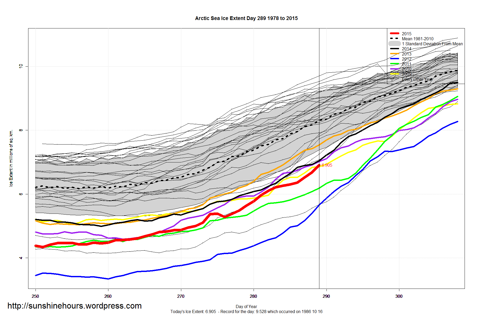
Have you ever been right?
Arctic sea ice dipped between 2006 – 2012, during one of its normal and natural fluctuations. For the last several years it has been recovering:
Global ice is at its long term average because Antarctic ice (what this article is about) has been steadily rising.
I always laugh at the chumps who make a big deal out of “ice”. They’re from the same contingent that endlessly predicted that Arctic ice would disappear by 2013 or 2014.
How’d those pathetic predictions work out?
simple Simon says:
Simon? Advice?!
Coupled with a quite aggressive response too? A less than subtle threat?
Innocuous innocent pleadings followed by more aggressive full of one’s self importance comments?
Kenny Rice? ATTP? Or is it Bad Billy Connelly? Perhaps its Joel?
Whatever, you are an overused dingy sock puppet, likely smelly too. (See, a proper use of ‘likely’; unlike those false climactivist abuse of the English language.) You can’t even frighten people well anymore.
All of your response towards me is that threatening stuff; couldn’t you rebut even a small piece of my comment? Or are threatening stances and poses all you’ve got?
Perhaps you are dimly aware of the world where people bet their own money on following charts and recognizing when the charts have registered a change?
It’s called the stock market.
The chart data long recognized as signaling a bottom is here. One version is called a head and shoulders bottom; another version is called the double bottom, yet another version is called the triple bottom.
Ignoring one chart signal is common. Ignoring two solid chart signals is not. Most brokers would be setting up their buys and many pulling the trigger. A third chart bottom signal setting up would unsettle even the most hardened trader.
These folks put their money behind this information whereas climactivists prefer to play with other people’s money.
ATheoK
So… let me get this right… you are saying that because the stock market can bottom bounce, that is clearly what is happening in the Arctic? Really? That is the best you have? And you call me pathetic. Ha ha that’s very good.
I like to actually look at the Arctic when I talk about what is happening the Arctic. I think you would be well served to do the same and leave your stock market phrases to the.. well… stock market.
Simon
OK. Now, what exactly causes you to “fear” any current or future addition loss of Arctic sea ice?
Increased loss from today’s sea ice extents only means a net yearly loss of heat energy from the planet seven months of the year. A minor gain April-August, but one which is more than made up by the increased reflectivity from the 30 years of increasing Antarctic sea ice.
Simon:
So you’ll happily accept bad model results, upside down data in oddball statistics, fudged temperatures, frequent ever more noxious alarms of catastrophic weather,…
But, you turn your nose up at solid financial logic that experts use to track virtually every product, commodity, currency, stocks, bonds and even real estate?
I believe you are correct in one aspect, pathetic isn’t depressed or piteous enough for you. You are in your own mal-adjusted world.
Simon says one year is a trend.
No, Simon, this is a trend:
DB
When did I say one year was a trend?
Sorry, Simon, that was your twinotter. My misteak.
I would agree that the strong EL NINO has had an influence on Antarctic Sea Ice to some extent but nevertheless the Southern Ocean is much colder then normal as will be seen by the next post I send.
http://www.ospo.noaa.gov/data/sst/anomaly/2015/anomnight.10.15.2015.gif
Thanks Sal. Does this make you think ” Scientists believe this year’s strong El Niño event, a natural phenomenon that warms the surface waters of the eastern equatorial Pacific Ocean, had an impact on the behavior of the sea ice cover around Antarctica.” need to learn how to read a map?
DD More,
No it means the gullible press need to learn to ask questions and understand when they are being considered stupid. A brief glance at a map like Salvadore’s and similar will show the cold oceans around the Antarctic and the cold Humboldt current with South Easterlies pushing it North to Peru. The ‘scientists’ should have been met with raucous laughter and told to try to pulll the other one.
With no comments made by you, some people might not know the correlation with earth quakes in sea nor do most people understand how the seven most essential Ocean currents change due to seasons….
Is that pool of cold water growing south of Greenland?
Yes, it is in fact growing.
You can here the sigh (at las) from here. They seem desperate to report the average sea ice.
The 22nd lowest maximum sea ice extent! OMG, the AGW crowd is right and this proves it. It’s only a matter of a few years until New York city and Florida will be under water.
As long as wherever the beach ends up it’s still open.
The pattern of several several years up and then1 or 2 down is somewhat normal.
http://wp.me/a1ASzZ-2al
Now where have I seen that Sawtooth pattern before?
3 years increasing is just natural variation but one year decreasing is a trend and a return to normalcy. Are they completely brain dead or can they not see the sheer idiocy of what they have just written
Called Groupthink and where ever it continues in a field there will be no break through science.
Group members try to minimize conflict and reach a consensus decision without critical evaluation of alternative viewpoints, by actively suppressing dissenting viewpoints, and by isolating themselves from outside influences. Loyalty to the group requires individuals to avoid raising controversial issues or alternative solutions, and there is loss of individual creativity, uniqueness and independent thinking.
This is full on in climate non-science and why the quality of science is almost nonexistent.
The aside about Arctic ice is wrong. It appears to be recovering both in extent and volume (multiyear ice). This year was the earliest low and the fastest refreeze since 2000.
Volume in the Northwest Passage is growing quickly, I’m waiting to see what happens next August when 1000 lucky victims, er … passengers, who have already laid down 22,000 each to cruise the NWP, find that a luxury liner is not the best option for travel north of the 80th parallel.
Over on the Russian side Bolshevik Island is already socked in, about 2-3 weeks ahead of schedule. Guess anyone planning any more freight transit in that area can ante up an additional 350,000 Euros to have a Russian ice breaker hang around, and then another 250,000 Euros if the ice breaker actually has to do anything.
Mark from the Midwest October 16, 2015 at 9:16 am
Volume in the Northwest Passage is growing quickly, I’m waiting to see what happens next August when 1000 lucky victims, er … passengers, who have already laid down 22,000 each to cruise the NWP, find that a luxury liner is not the best option for travel north of the
870th parallel.At least three cruise ships made the passage successfully this year, why do you think next year will be different?
Phil:
If your talking about trips on the Endeavor, it’s not a 1000 passenger luxury liner, it’s a 150 passenger boat, built specifically to operate in hostile environments, there’s a big difference. A lot of smaller specialized craft can work their way through the Northwest Passage in any year, but a cruise ship is absurd, even if the ice volume and extent goes down to 2012 levels
Really, This one and her sister ship managed it easily this year:
http://cdn.travelpulse.com/images/99999999-9999-9999-9999-999999999999/cbaa4c87-c23d-e411-95bd-0050568e420d/630×355.jpg
http://d32np4uylixs8c.cloudfront.net/~/media/images/ships/le%20boreal/leboreal_header.jpg?revisionid=07_55_2011
Should read “north of the 70th parallel,” I saw the error at the moment I hit the post button … hey but there’s a lot of ice in Hudson Bay, which is also 2-3 weeks ahead of schedule
Mark from the Midwest
Hudson Bay is right at 1.2 Mkm^2, and is a very good circle centered at latitude 60 north. All of it covered by “Arctic” sea ice at Arctic maximum (mid-to-late March every year) and all of it melted out by mid-to-late July each year. It re-freezes a bit later than the Arctic minimum point of mid-September because of that lower latitude. (The Baltic Sea, Bering Sea, and Okhotsk Sea are also right on that 60 degree latitude range.
It’s a good question about analyzing these separately from the “classic” Arctic sea ice definition and measurements, but nobody else does. And everybody but “arctic sea ice nerds” would get lost if you began a separate sea ice energy budget for 1/4 of the Arctic than the remaining parts.
Frankly, I have not found ANYBODY else worldwide (other than yourself!) who has even noticed Hudson Bay is at a significantly lower latitude than the “rest” of the Arctic Sea Ice. But, well before the arctic sea ice minimum in September, everything but tiny traces south of latitude 70-71 has melted out.
Typical Meier quote. Deviating from what he’s reporting on to include his agenda …
Hey, a guy’s gotta keep his job safe until he’s eligible for his pension, I know where he’s coming from.
Seven months of the year, the southern edge of the Arctic sea ice has virtually no sunlight shining upon its surface. When sea ice area is below its normal area for the date during those seven months, the losses from the uncovered open Arctic waters LOSE HEAT to space and the planet has a net COOLING EFFECT due increased evaporation, convection, long wave radiation and reduced conduction losses.
Thus, under today’s conditions, from September 1 – including that dreaded sea ice “minimum” so feared by the government-paid Arctic sea ice community – until the end of March, “Less Arctic Sea Ice = More Cooling.”
Now, April-August, the Arctic Ocean DOES gain some heat energy from the increased solar exposure of darker ocean water. But these Arctic leads and melt ponds begin re-freezing 12 August, when the heat losses over each 24 hour day = the small amount gained from the sun.
But, the Antarctic has been setting RECORD-HIGH sea ice extents the past three years (2012, 2013, 2014) and has been increasing since 1992 during all phases of the Antarctic year ((spring maximum, summer melt period, early fall minimum, and winter freezing.) Note that the “excess Antarctic sea ice area” just last June was just a bit larger than Greenland. (That record high Antarctic sea was set during the few dark weeks of the year on the sea ice edge, but the Antarctic sea ice anomaly has been more than 2 std deviations above the established “average” for almost all of the past three years.)
And, unlike the very high latitudes of the very little bit of Arctic sea ice in September (latitude 80-81 degrees), ALL of this inconvenient “excess” Antarctic sea ice IS at latitudes where the increased sea ice reflects more energy back into space 10-1/2 months of the year. (The northern edge of Antarctic sea ice is in the dark only some 30-40 days a year.)
Making it worse (for the CAGW community’s fears and justifications) this ever-increasing Antarctic sea ice is 1.65 to 1.7 TIMES as effective in reflecting solar energy than the Arctic sea ice is. So, each “extra” million square kilometers of Antarctic sea ice needs to be offset (over a year’s time) by 1.7 million square kilometers of Arctic sea ice.
Losing all Arctic sea ice? (Even at the stupidly simplified – “Well that would be during the September minimum extents.”?
Well, losing that Arctic sea ice in September will only serve to cool the planet more.
Is the extra Antarctic sea and the missing Arctic sea ice the past 20 years the cause for the “pause” ? Well, all that extra reflected heat down South, and all that “assumed” absorbed heat up north (which has been lost to the Arctic Ocean at ever-increasing rates) is no longer on earth.
On top of the reflective nature of the Antarctic Sea Ice is also the cooling affect it has on the local Seas as the low pressure systems circulate warm air from the sea and cool it over the ice and thus also cooling the sea’s surface.
The sea around Antarctica is very cold and that cold extends up to the southern tip of Africa, New Zealand and Tasmania.
I download the raw data for Antarctic sea ice extent from NSIDC today (SH_seaice_extent_nrt.csv) and according to that the maximum extent was on the 2 October (18.874) and not on the 6 October (18.83). There are I notice however a couple of spurious values in that file though, one on 14th Oct (19.825) and an even larger value of 20.723 on September 23rd. They are obviously having a QC problem with this data.
What’s QC?
Qualified Cook
Quality Control
Quality Control.
They had a similar problem with the Arctic data file a few weeks ago which I reported to them and they confirmed. I have been using their data for some time and never come across any spikes in the graphs till then. It could easily be fixed in software.
Questionable Content.
Quarrelsome Commentator
Would this be related to this – ? (I have no more knowledge about whether it was spurious or not, or how it was caussed or if it is an artifact.
With Paris close at hand I’m skeptical of any headlines about climate. The bigger the headline, the more likely the finding is political rather then scientific. This is what Climate Science has become in the 21st century. PT Barnum write large. Hucksterism masquerading as science.
It’s not down to ocean temperatures with recently having one of the coldest months since 1979.
http://i772.photobucket.com/albums/yy8/SciMattG/UAH_AntarcticOceanTemps_zpsyk6tsbmm.png
Forgot to mention that was why the maximum extent was later this year.
If I had to wager a guess, I’d say it’s probably wind patterns caused by El Nino. Wind trumps temperature every time where sea ice is concerned.
I agree that the maximum ice extent this year was affected by El Nino.
The years that the Antarctic sea ice has laughed in the face of AGW protagonists as it denied all exaggerations of its death as premature, made me laugh when the warmista’s revolutionary guard just like Sadam Hussein’s Comical Ali, distorted reality and claimed the record se ice was an [artifact] of runaway global warming. So now the iced has reduced by a significant amount this SH winter, then according to the AGW theory that the sea ice grows when the planet is warmer, then based on that logic, it can only follow the earth is cooling.
I’m not sure that Comical Ali took himself all that seriously. I suspect that he knew that he was making ludicrous claims.
However, before I arrived within the sanctuary of WUWT I did encounter internet threads in which people very seriously and confidently explained that the Antarctic was like a big ice cream desert, which as it warmed, was spreading out…no wait…it’s the increased winds, which are more extreme than any winds for 10,000years according to examination of a tree in Chile.
Actually, that is not an entirely accurate recollection of what they said. But I stopped paying attention as soon as I realized that there are people out there who are willing to create a post hoc explanation for why almost any observed event or trend is caused by increasing AGW. Including stuff getting colder!!
“But, the Antarctic has been setting RECORD-HIGH sea ice extents the past three years (2012, 2013, 2014) and has been increasing since 1992 during all phases of the Antarctic year ((spring maximum, summer melt period, early fall minimum, and winter freezing.) ”
Antarctic ocean temperatures have been declining since 1992, so it has been no surprise that sea ice extents have been increasing since 1992. If there were any unlikely doubt’s about satellite’s temperature observations compared to surface around Antarctica then this proves otherwise. There is so much evidence like this that show alarmists at their worst and will do anything to support the political agenda, including not using far superior observations data sets.
I wouldn’t go so far as to say the Antarctic is demonstrating “normalcy”. The satellite era does not, by itself, define normalcy. When looking at the regular periods of global steps to deep cold, the rise to warmth is sudden and shortlived, according to the reconstructions from proxies. What the Antarctic sea ice looks like during these downward steps has been unobserved by anything other than what lives in the cold circumpolar current. What we don’t know about “normalcy” is a lot.
“There may be more high years in the future because of the large year-to-year variation in Antarctic extent, but such extremes are not near as substantial as in the Arctic, where the declining trend towards a new normal is continuing.”
Nobody knows what normal is and ocean cycles are largely responsible for the variable trends in Arctic ice.
June 1977 Arctic ice extent was hardly any different to June 2000 after a period of 23 years.
http://i772.photobucket.com/albums/yy8/SciMattG/SeaIceExtentJune2000vJune1977_zpsitcm5d58.png
Arctic temperatures have only warmed very little since 2001, so the change in Arctic ice extent since then had hardly nothing to do with this, but the AMOC, AMO and PDO.
http://i772.photobucket.com/albums/yy8/SciMattG/UAH_ArcticTemps2001_zps4ffhcszg.png
http://ocean.dmi.dk/satellite/plots/satsst.arc.d-00.png
http://ocean.dmi.dk/satellite/index.uk.php
Any comments on the purported thinning of Antarctic sea ice? You hear a lot about that from Warmists. Wider but thinner?….anyone?
“Since it is not possible to estimate the long-term (interannual or decadal) variability
for the sea ice thickness field from the ASPeCt data set, we
have focused on providing seasonal, and where possible,
regional estimates of statistics.”
http://onlinelibrary.wiley.com/doi/10.1029/2007JC004254/pdf
Thanks!
You could remind them that the ‘Ship of Fools’ got stuck in this thin ice. The first ice-breaker that tried to reach it got stuck in this thin ice.
That “Ship of Fools” incident, as entertaining as it was, only had to do with sea ice. The concern about ice thinning is, as I understand it, more associated with land ice. The paper for which Matt G sent me the link deals with this, though it is almost ten years old..
As usual…the bottom line seems to be lack of representative sampling and a limit of only a few decades of history. Makes it hard to measure the Earth’s processes, doesn’t it?
I also read at one point that there is a paper out discussing geothermal heat causing melting in Antarctica. If anyone has anything substantive on this I would love to see it.
The question was about sea ice
Ooops…my bad. Sorry
The question I keep thinking about: “Is the earth bi-polar?”
Posts here and elsewhere have suggested that there are multi-decadal or longer swings that show the Antarctic cooling while the Arctic warms; then some 100 or so years later the opposite happens – and some have suggested shorter time frames for this see-saw action; or some sort of lead/lag effect. Perhaps I have been reading things incorrectly. I think I read that Mars has a similar see-saw between the poles outside of the annual variation. Thermohaline circulaton, albedo, convection, orbital mechanics, or???
Just curious if my impression is real, or just poor comprehension of what I have read.
Tilt and wobble of the Earth changes the poles position relative to the sun .
There is a bi-polar seesaw pattern, but not all areas of Antarctica behave this same way.
“Ice-core records of climate from Greenland and Antarctica show asynchronous temperature variations on millennial timescales during the last glacial period1. The warming during the transition from glacial to interglacial conditions was markedly different between the hemispheres, a pattern attributed to the thermal bipolar see-saw2.”
http://www.nature.com/ngeo/journal/v4/n1/abs/ngeo1026.html
“In this paper we show that the 20th century de-trended Arctic and Antarctic temperatures vary in anti-phase seesaw pattern – when the Arctic warms the Antarctica cools and visa versa. This is the first time that a bi-polar seesaw pattern has been identified in the 20th century Arctic and Antarctic temperature records. The Arctic (Antarctic) de-trended temperatures are highly correlated (anti-correlated) with the Atlantic Multi-decadal Oscillation (AMO) index suggesting the Atlantic Ocean as a possible link between the climate variability of the Arctic and Antarctic regions.”
http://onlinelibrary.wiley.com/doi/10.1029/2010GL042793/full
The bipolar see-saw theory is quite well established. It appears to be based on the Atlantic being the only ocean that transfers heat northward across the equator. This is based on the temperature gradient from the Southern ocean at about 30°S to the North Atlantic that are connected by the Atlantic Meridional Overturning Circulation, also known as the conveyor belt. When the gradient is high the AMOC transports heat from the Southern Ocean, thus cooling Antarctica and warming the Arctic. When the gradient is low AMOC weakens, Antarctica warms and the Arctic cools. Some people call this Northern Hemisphere heat piracy.
Gaia forgot to take her lithium.
Wayne
On that note, does the same thing happen during the Ice Ages? One hemisphere in ice, the other not. If thats the case, how would that effect or change the ice core data, if the assumptions about the data conclude that all is equal in both poles at the same time period in a sample…Assuming that both hemispheres were in ice ages at the same time from samples taken from both N and S ?
Anybody get that…Having some trouble getting things out today. This has probably been thoroughly worked out, but I haven’t seen it discussed anywhere. And even ice core data from interglacials?
Greenland has had glacier ice for around 3 million years and Antarctica for around 30 million years. ?w=2480
During ice ages both poles had huge amounts of ice around them or nearby, the bipolar warming and cooling changes made no difference to the glaciers there because it was far too cold.
http://paos.colorado.edu/~fasullo/1060/gifs/iceage.gif
The bipolar changes also had reduced difference in the NH with huge amounts of energy failing to move further North than between lower Canada and lower Spain. With only a little or none affect from the AMOC, bipolar changes would had been reduced in the Northern Hemisphere, but the circulation between Mid-Atlantic ocean and South Atlantic continued.
The Big Island in Hawaii has hosted glaciers on the highest volcanoes. Still freezes ever every winter.
One of the last quotes in the article referred to a “new normal,” which according to the usual definition of the term is not possible. Once something is found or determined to be normal, it doesn’t change. You don’t find a “new normal” human body temperature; it’s still 98.6 F. You won’t find a new normal standard for visual acuity; it’s still 20/20. I dislike the use of “normal” to mean “usual” (which “normal eyesight” is not) or “average.” The amount and temperature of Antarctic ice and ice coverage will vary from year to year, even from day to day; that variation is, indeed, normal, expected, validated by past records, observations, and experience. A particular value, however, can be arrived at only as an average or as a discrete instance; it is not, and can never be, normal. There is no norm for weather or climate numbers. Right now, here in south central Virginia, the temperature (at 1:15 p.m.) is 54 degrees, well below average. Is this day therefore abnormal? No; it’s just a cool, cloudy day with occasional spits of rain, after passage of a cold front; not abnormal, just a bit below average. Again: In this respect, there is no norm.
Very valid point. As soon as someone starts talking about “normal” values of something in climate it is a veiled reference to ‘abnormal’ conditions. When they use the expression “now normal” they are trying to say that things will never been the same again , OMG , etc.
ie it’s PR spin not science. This downward trend in science is becoming the new normal !!
Thanks, Anthony.
No wonder why global sea level rise does not accelerate; Antarctic ice is refusing to fall in the ocean, it is too cold!
http://www.dynamicpaleoclimate.org/uploads/2/3/5/4/23543390/417.full.pdf
Excellent study on how the climate at one pole may be connected to the climate at the other pole.
This just sounds like the ‘polar see-saw’. One end goes up while the other goes down.
It is uncanny that after a decade of scare stories and DEATH SPIRALS in the Arctic, they’ve all suddenly lost interest and are going “OMG, look over here! The ANTarctic is melting so fast that in 9000 years much of it may have melted”.
We’re probably going to be talking about the catastrophic decline in Antarctica for another 20y or so until the it swings the other way again.
http://climategrog.files.wordpress.com/2014/06/ant_arctic_melting_season_lag.png
The length of the melting seasons is roughly complementary at each pole, with the S. Pole lagging by about 3 years.
https://climategrog.wordpress.com/?attachment_id=965
On the basis of that relationship, and with the Arctic showing strong recovery in the last 3 years, one would expect the Antarctic to turn towards decline starting this year.
I have a model that predicts intense interesting in SH sea ice for at least the next three years. This will become the new normal for alarmists.
Wait…You mean something that increases can also…Decrease? It’s almost as though there’s some sort of…Variability or something. Who would have thought such a thing? Here I thought that once something increases, it’s supposed to continue increasing unabated like temperatu…Wait, maybe house price…No, stock marke…No. I’m so confused.
/Heavy sarcasm
The hockey stick will help your confusion.
Ater July 5 the daily numbers (bootstrap and nasateam) like like someone screwed up the shell script or revised a directory so the shell script reads the wrong file.
The Antarctic sea ice will soon be settling new historic records.
The recent high latitude warming was caused by solar wind bursts which in turn are caused by solar coronal holes. Very recently there has been an observational change in the coronal holes, the occurrence of patches which indicates the mechanism that is creating the coronal holes (something deep within the sun is changing).
The solar wind bursts create a space charge differential in the ionosphere which causes a current to flow from high latitude regions to the equator. The current flow causes cloud property changes at both high latitude regions and the equator that causes warming at both locations. The effect lasts for 3 to 5 days so a string in time of solar wind bursts are required to cause warming.
Coronal holes persist for months and occur at all times during the solar cycle. Coronal holes can if the occur late in the solar cycle make is paper that high GCR (galactic cosmic rays, silly term for mostly high speed cosmic protons that are modulated by the solar heliosphere. The solar heliosphere is the name for the tenuous gas and piecemof magnetic flux that is pushed by the solar wind to well past the orbit of Pluto. The solar heliosphere is blocks GCR. The solar heliosphere extent and strength is greatest when the solar cycle is at its peak and during strong solar cycles.) The solar wind bursts are the reason for the current El Niño conditions.
The solar wind bursts cause a sudden change in the geomagnetic field which is measured by the parameter Ap. (See this link which provides a graph of Ap and also shows picture of the sun which shows the occurrence of patches in the coronal hole. There has also bee papers written concerning the changes to coronal holes and the appearance of coronal holes late in the solar cycle.)
http://www.solen.info/solar/
As I have stated a number of times, it appears the solar cycle has been interrupted which is different than a slowdown in the solar cycle.
The sun is more complicated than a simple fusion furnace.
The coronal holes are high speed protons streams that ejected from something deep within the sun. An observation to support that assertion is the fact that the rotational speed of the coronal holes is not reduced with increasing solar latitude indicates the high speed proton wind which we call coronal holes is created deep within the sun.
http://iopscience.iop.org/article/10.1088/0004-637X/763/2/137/pdf
Not sure what you’re saying here 😉
The solar wind bursts from coronal holes remove cloud forming ions in high latitude regions and cause warming in the tropics due to a change in cloud properties and cloud duration in the tropics by a mechanism that is called electroscavening. Less ions, less clouds colder planet.
Galactic cosmic rays (GCR, the name for mostly high speed cosmic protons) create cloud forming ions in the atmosphere which is called ion mediated nucleation. More ions more clouds colder planet.
The solar heliosphere blocks and deflects GCR, so when the solar cycle is strong there is less GCR.
Normally when the solar cycle is weak and at the end of the solar cycle when the cycle the higher GCR would cause more cloud cover and would cause cooling. What inhibits the cooling is solar wind bursts which remove ions.
http://www.utdallas.edu/physics/pdf/Atmos_060302.pdf
Observations of changes in cloud properties that correlate with the 11-year cycles in space particle fluxes are reviewed. The correlations can be understood in terms of one or both of two microphysical processes; ion mediated nucleation (IMN) and electroscavenging. IMN relies on the presence of ions to provide the condensation sites for sulfuric acid and water vapors to produce new aerosol particles, which, under certain conditions, might grow into sizes that can be activated as cloud condensation nuclei (CCN). Electroscavenging depends on the buildup of space charge at the tops and bottoms of clouds as the vertical current density (Jz) in the global electric circuit encounters the increased electrical resistivity of the clouds.
Space charge is electrostatic charge density due to a difference between the concentrations of positive and negative ions. Calculations indicate that this electrostatic charge on aerosol particles can enhance the rate at which they are scavenged by cloud droplets. The aerosol particles for which scavenging is important are those that act as insitu ice forming nuclei (IFN) and CCN. Both IMN and electroscavenging depend on the presence of atmospheric ions that are generated, in regions of the atmosphere relevant for effects on clouds, by galactic cosmic rays (GCR). The space charge depends, in addition, on the magnitude of Jz. The magnitude of Jz depends not only on the GCR flux, but also on the fluxes of MeV electrons from the radiation belts, and the ionospheric potentials generated by the solar wind, that can vary independently of the GCR flux. The roles of GCR and Jz in cloud processes are the speculative links in a series connecting solar activity, the solar wind, GCR, clouds and climate. This article reviews the correlated cloud variations and the two mechanisms proposed as possible explanations for these links.
http://sait.oat.ts.astro.it/MmSAI/76/PDF/969.pdf
http://www.cpc.ncep.noaa.gov/products/stratosphere/temperature/70mb6590.png
http://www.cpc.ncep.noaa.gov/products/stratosphere/temperature/70mb2565.png
theres been 2 massive blips over the last month .. my guess there fiddling the numbers ..
with Paris coming up ..it has to be seen as melting ..
Really cracks me up to see a govt “expert” applauding the lack of linearity in nature.
Who but the govt would insist nature does not ebb and flow?
DMSP F17 loosing data. Which could mean an @satellite transmission problem or an @groundstation data transmission problem.
Which means that the daily (am or pm or both) Antarctic sea ice area extent is bogus.
Subject: Product Outage/Anomaly, DMSP SSMI/S F17 data lost, Issued:
This is a multi-part message in MIME format.
–Boundary_(ID_NdLtm7FDnQ38SGV5Ma704A)
Content-type: text/plain; charset=windows-1252; format=flowed
Content-transfer-encoding: 7BIT
*Topic: *DMSP**SSMI/S (Special Sensor Microwave Image/Sounder) F-17
rev. 45478 was lost*. *
*
**Date/Time Issued**:*August 29, 2015 0145Z*
*
*Product(s) or Data Impacted:* F17 rev. 45478
*Date/Time of Initial Impact:* August 28, 2015 2119Z**
*Date/Time of Expected End:***August 29, 2015 0125Z
*Length of Event:*Approximately 4 hours
http://www.ssd.noaa.gov/PS/SATS/SPBULL/MSG2410144.01.txt
Ha ha
If the south warms the north cools I thought this was settled science?
Various observers have noticed that there is a curious ‘double system’ working at the present time. The South is still very cold indeed, but the allied meridional instability has been temporarily overcome by an early and strong vortex-strengthening. Circum-polar winds have been fierce, along with more northerly flows from sub-antarctic systems (reaching up into our southern home nations still).
The ‘Blob’, allied to El Nino, has lifted the equatorial tropopause for a while. The increased gradient, I suspect a somewhat odd one, is what has caused the above fierce winds. They chopped the top off the sea ice growth, but it is now above the multi-decadal average used, and nowhere near significantly low. In spite of warmist pathos, it is just interesting scientifically, not disastrous. Post the Blob, that will be interesting too. Possibly not happy for warmistas, nor for we who have trouble affording heating.
100%
Brett Keane
http://services.swpc.noaa.gov/images/solar-cycle-planetary-a-index.gif
From 2000 – 2007 the Antarctic sea ice was declining because Global Warming was melting the sea ice
2007 – 2014 the Antarctic sea reached record levels because Global Warming was melting land ice which was reducing the salinity of water around Antarctic.
2015 – ?? Antarctic sea ices are normal because Global warming is causing…….
@ William Astley
October 16, 2015 at 1:30 pm: Oops. Forgot to mention the vigourous space weather.
All this Antarctic ice is caused by Global Warming, of course.
For what it’s worth we are having a cold spring here in Chile. The resorts in Santiago just extended the ski season until November, which is highly ‘unusual’. So, yeah, weird weather down here. The locals all say it’s El Niño but there was also talk that the last earthquake was because Chile legalised abortion so go figure.
ANTARCTIC SEA EXTENT FALLS AT RECORD RATE AS CO2 INCREASES!!!!!!!!! MOST DRAMATIC DECLINE SINCE RECORDS KEPT!!!!!!!!!!!!
Something like the above will appear somewhere.
Eugene WR Gallun
Oh, yes, should have added something like — OCEANS IN DANGER!!!!!!
Eugene WR Gallun
And you also left out the obligatory, “WE’RE ALL GONNA DIE!!!!!” as well as the bottom line, “Unless you give us all of your money and do what we tell you to do. (And get rid of those @#&% cows!!!!)”
I’m sure you won’t make that misteak again, Eugene ;o)
Reblogged this on Norah4you's Weblog and commented:
It had been better for everyone had the alarmists been listning in on teachers trying to teach them Archimedes principle as well as Photosynthesis and Erosion
and of course basic knowledge of Natural Forces…..
Isn’t land ice disappearing quite rapidly and that is the most concerning factor? Sea ice may have held in area but it is land ice melting that will contribute to sea level rise.
Owen
A very little bit of land ice (compared to the total volume of continental ice + Greenland + Antarctica) is melting out each year, compared to what is added each winter. We are, after all, still warming up from the lowest point of the Little Ice Age in 1650, and still likely have one more 66 year short cycle to go before cooling down into the Modern Ice Age 500 years from now. The items and bodies now being uncovered by retreating mountain glaciers only proves that “the glaciers were as far retreated (back then) as they are now!
But the “incredibly high ice volumes” that the headlines scream out – like this one, emphasizing that “2015 was millions of square kilometers lower than previous record-setting years” is misleading. Deliberately misleading, in fact.
Here’s how they make Arctic ice decline seem scary when it isn’t:
https://rclutz.wordpress.com/2015/10/06/arctic-ice-made-simple-2/
Magnetic activity of the sun was high and the polar vortex was strong.
http://oi59.tinypic.com/23kdwl2.jpg
Therefore, the temperature in the stratosphere over the polar circle very low.
http://www.cpc.ncep.noaa.gov/products/stratosphere/temperature/70mb6590.png
The low temperature also in the lower latitudes.
http://www.cpc.ncep.noaa.gov/products/stratosphere/temperature/70mb2565.png
Antarctic ozone today: Ozone depletion is now extensive and the ozone hole covers Antarctica. The ozone hole grew rapidly from mid August onwards and is near its largest at some 25 million square kilometres. This is a larger hole than the average of those over the last decade.
http://theozonehole.com/images/sep272015ozone_hole_plot.jpg
http://theozonehole.com/2015.htm
http://iceagenow.info/2015/10/antarctic-sea-ice-again-surges-upward-video/#comments ? what do you make of this
http://arctic.atmos.uiuc.edu/cryosphere/NEWIMAGES/antarctic.seaice.color.004.png
Wait, so a little temp variance in the arctic means nothing but in the south it means everything?
I call shenanigans. Go home, skeptic eejit, you’re drunk.
Meanwhile, the Arctic ice recovery continues:
https://rclutz.wordpress.com/2015/10/18/arctic-ice-great-leap-upward-oct-17/
I propose a yet-to-be characterized oscillation between Arctic and Antarctic sea ice (or more properly, a large scale oscillation impacting multiple ocean basins).