Guest Post by Bob Tisdale
The post provides a look at the most recent weekly sea surface temperature anomalies for the equatorial Pacific. It also includes a Hovmoller diagram of the wind stress (not anomalies) along the equator…to confirm that there was another westerly wind burst at the beginning of last month.
NOAA’s weekly sea surface temperature anomalies for the NINO regions (based on Reynolds OI.v2 data) are furnished on Mondays. Today’s update for the week centered on July 29, 2015 shows the sea surface temperature anomalies of the NINO3.4 region (5S-5N, 170W-120W), which NOAA uses to define an El Niño and its strength, is at 1.7 deg C, just above the 1.5 deg C threshold of a strong El Niño…where it’s been hovering for a few weeks. But it’s still early in the development of an “average” El Niño, which typically peaks in December.
The weekly NINO region sea surface temperature anomaly data for Figures 1 and 2 are from the NOAA/CPC Monthly Atmospheric & SST Indices webpage, specifically the data here. The base years for anomalies for the NOAA/CPC data are referenced to 1981-2010.
Figure 1 includes the weekly sea surface temperature anomalies of the 4 most-often-used NINO regions of the equatorial Pacific. They start in January 1990. From west to east they include:
- NINO4 (5S-5N, 160E-150W)
- NINO3.4 (5S-5N, 170W-120W)
- NINO3 (5S-5N, 150W-90W)
- NINO1+2 (10S-0, 90W-80W)

Figure 1
And for Figure 2, the evolutions of the sea surface temperature anomalies in 2015 are compared to 1997 as a reference for a very strong El Niño and compared to 2014 as a reference for a very weak El Niño. Keep in mind that 2015 started the year at or near El Niño conditions, where that was not the case in 1997 and 2014.

Figure 2
ANOTHER WESTERLY WIND BURST
In the post ENSO Basics: Westerly Wind Bursts Initiate an El Niño, we discussed how westerly wind bursts prompt the downwelling Kelvin waves that appear early in the development of an El Niño. Later in the process of El Niño evolution, westerly winds bursts also help to push more warm surface water than normal eastward along the Pacific Equatorial Countercurrent. So they too help to strengthen an El Niño.
The most recent update at the NOAA GODAS website includes the 12-month Hovmoller of wind stress (not anomalies) along the equator through July 27th. See Figure 3. It shows yet another westerly wind burst in late June/early July. That westerly wind burst should be the response to the two tropical depressions that recently straddled the equator in the west-central tropical Pacific.
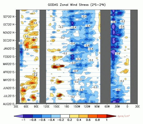
Figure 3
That’s all for now. I’ll try to provide the full update next week when the data for July are available. I’ll also try to provide an update on The Blob next week.
Since July grew only 3.4 Niño.
Others have fallen.
??
Are you thinking the El Niño is now weakening?
http://www.cpc.ncep.noaa.gov/products/analysis_monitoring/enso_update/ssta_c.gif
Something that’s always confused me…
During the last big ’97 El Nino the sea surface temperature shot up. Got that, I understand that (I think). It’s accumulated warm water moved by the winds.
And then it started to drop again. Got that, I understand that (I think). It’s the dissipation of that warm water.
But in ’97 it didn’t just cycle down. It started to drop and then shot back up again. Why?
Was it two El Nino’s superimposed?
Or was there some change in the wind or currents that restarted the El Nino process?
Predictions now for the end of the year, please.
MCourtney, in Figure 2, I don’t see a down cycle for 1997 in the NINO3.4 sea surface temperature anomalies.
What I mean is that the temp drops down and then spikes up again. There’s a definite V-shape at the top of that peak (with the latter side being less tall).
On the Nino 1+2 Sea Surface temp anomalies (Reynolds Ol. v2), I mean.
Why did it shoot up again?
Or am I just misunderstanding the graph? (Unusual, but sadly not unheard of).
MCourtney, that 1997/98 El Nino was studied upside and down. There may be a paper that explains it, but I don’t recall ever coming across one.
One possible explanation for the subtle dip and rebound in the NINO1+2 SST anomalies that year is the season-long gap in the westerly wind bursts in 1997.
And looking at Figure 1 above, there may be a seasonal component in the NINO1+2 SST anomalies.
Cheers
Thanks Bob Tisdale. That does explain the doublet. The El Nino is paused and then recharged when the winds slacken and strengthen seasonally.
As El Nino’s are associated with a specific time of year (hence the name) that’s shouldn’t be a surprise.
But I’ve not heard it discussed before either. And it does make a difference.
It means an early slackening of wind can discharge an El Nino with little long-term impact as it will continue to be discharged through the late Summer/Autumn slackening period. And that means the size of the accumulated warm water reservoir is not sufficient to describe the size (impact) of the resultant El Nino on its own.
This has been nagging at me for a while. I suspect it’s newly stated in the world.
Although it may have been considered too trivial for the experts to state.
Hi MC
In my view the Enso, in the long term, is relatively neutral. I tend to see the Central Pacific huge water mass as stable, while the slender layer of the SST may go up and down.
On the multi-decadal scale, global temperature changes originate further north, driven by currents flowing along East Asian and East American coast lines transporting some of the excess equatorial heat energy, which otherwise would be radiated back to the space. I would suggest that the prime responsibility is with the North American tectonic plate, with its boundaries in the Icelandic (down-welling) and Aleutian (up-welling) regions, where there is strong interaction of the warm and cold currents.
Thanks V.
That may be correct.
But it doesn’t explain the doublet peak in that ’97 El Nino. It just says the explanation will be found in the Northern Hemisphere.
vukcevic says, “In my view the Enso, in the long term, is relatively neutral…”
That opening sentence to your comment clearly indicates you do not understand ENSO.
Mr. Tisdale, I wouldn’t dare contradict you, just go by what I see elsewhere and sounds logical.
http://www1.ncdc.noaa.gov/pub/data/cmb/teleconnections/eln-f-pg.gif
MC at 11.38 am
“But it doesn’t explain the doublet peak in that ’97 El Nino. It just says the explanation will be found in the Northern Hemisphere.”
I’ll put my neck on the block again.
Was there a typhoon at the time?
Typhoons are driven by the ocean’s heat energy. As typhoon meanders further north it takes huge amount of energy, this could lower the SST up to 5C or more in the directly affected area. The ocean currents tend to equalise the SST over period of time, but the trace of the dip in the temperature may have been reflected in the data. ( ? )
V at 1:36 pm
Yes, a tornado seems to be a weather event that would do the business.
But it would need to be a very big tornado to affect the whole of the area. They are big but localised.
Angular weather might do it though, I agree.
MC
Tornado’s are miniscule in comparison to typhoons
Super typhoon Paka started at 5N at the Nino boundary
http://www.aoml.noaa.gov/hrd/project98/pakapix/fig1a.gif
Off Topic Question. Does anyone know what happened to the200 yr to 1000 year time lad between temperature increase and CO2 increase in the ICE CORE DATA? The NOAA web site has made it disappear? Did I miss something? Thatas one of the biggest arguments against the warmists and now NOAA has made it go away on their w page showing a graph of CO2 and Temp over time. Funny thing is the text on the page saysTemp follows CO2 increase, but the graph shows temp LEADING CO2 increase?
Any help with this would be greatly appreciated. It like getting rid of the little Ice Age and the Midieval Warm Period Like Mann did with the Hockey stik?
The current El Niño appears to be losing momentum lately. Still a large event but momentum means a lot when the usual peak period of an El Niño is still 3-6 months away.
Still looks like a strong El Nino shaping up by 3Q to me.
is that the NE Pacific Blob, or The Gore Blob?
Look at Hamlington et al. in JGR 2015
climatologist, I haven’t had the pleasure of reading Hamlington et al. (2015)…
http://onlinelibrary.wiley.com/doi/10.1002/2014JD022674/abstract
In some respects, it sounds as though they’re discussing one of the numerous positive feedbacks associated with ENSO. That is, many El Ninos are developing before the May-June-July timeframe they mention in the abstract.
Also, they open their Abstract with:
“Past studies have described large-scale sea level pressure (SLP) variations in the Southern Hemisphere that lead to El Nino–Southern Oscillation (ENSO) warm and cold events (WE and CE).”
That sounds like SOI-based studies. But we can create an ENSO index from the SLP in the tropical North Pacific and show that “large-scale sea level pressure (SLP) variations in the…” Northern Hemisphere “…lead to El Nino–Southern Oscillation (ENSO) warm and cold events.”
Cheers.
Northism vs Southism?
Thoughts:
1. El Nino on the heels of a long, deep recharging clear sky La Nina. Lots of new energy to release as heat that was waiting at depth clear across the equatorial basin, with barely time to get mixed in or ride the currents to elsewhere. That would be quite some spike.
2. El Nino on the heels of a fairly long period of weak La Nina, La Nada, and a more cloudy El Nado neutral. Not much new energy to release as heat as it was already mixed and/or rode the currents to elsewhere. The ocean, to put it in an understandable phrase, has lost its memory. The El Nino SST spike would be less.
3. Results of initial evaporated heat during El Nino, regardless of the 3 dimensional depth, length, and breadth of the energy that is waiting its turn, would be similar. There are temperature spikes over the ocean and on land that are historically connected to ENSO processes. The actual experience of that El Nino and that degree of heat on a regional basis would be affected by whatever oceanic/atmospheric processes are in place at different locations, some driven by the El Nino in process, and some driven by other conditions.
4. I predict this El Nino, though long, will not match the steep spike like that of 97/98. There just isn’t enough energy to continue the spike upwards or for a long period of time. And because La Nina’s tend to follow El Nino’s, I also predict that we will have a pretty deep La Nina some time in 2016, if not initiated before then.
5. This whole process since 98 is feeling like a long term oscillation over a multi-decadal period of time. Will the evaporation of heat continue to increase in this jagged style and provide Medieval Warm Period spikes (that get averaged out in reconstructions)? That I don’t know. Especially since I see no reason why this process duplicates itself exactly from one sine wave to another.
6. There is no reason to suspect the puny addition of anthropogenic CO2 longwave radiation energy to the ocean as the driver of hotter longer El Nino periods. Back of the envelope calculations tells me not enough W/m2 from that source.
Correct Pamela. Especially point 6.
“And because La Nina’s tend to follow El Nino’s, I also predict that we will have a pretty deep La Nina some time in 2016, if not initiated before then.”
________
It’s a good thing California is building all those new desalinization plants….
One odd thing … which insofar as I can recall, hasn’t been around for an El Nino event: the more northern Pacific anomalous warming. I mean, it is a significantly warm Eastern Pacific practically from Alaska down to the Equator. A lot of heat-energy is built up.
Back in the day when Richard Henry Dana wrote “Two years before the Mast” (1834-1836), for at least 100 years California had a climate pattern that included near-hurricane force storms during 2-3 months of the late winter, which resulted in essentially impassable sea conditions for the same span. This is prosaically documented in TYBTM, where they were marooned-by-convention, until weather changed.
When the author returns some 20 years later on the same voyage, I noted with some interest that by the recounting of the local Californians, the climate had precipitously changed, and the usual late-winter 2 month period of ferocious storms had waned. by 1850 the winters were more clement. Again: insofar as I have been able to correlate, the ‘new’ pattern has been prevalent since that time with a few, yet notable exceptions.
The Great Flood of 1862 … which way by all measure a truly biblical event, which came about at the very end of a long period of drought. Hard to say if the drought that preceded it was much different than the last decades now… but it was one of the features. Possibly lead to a build up of Pacific thermal energy storage.
And these super-events are reckoned to happen every 100=200 years, with 2015 being 153 years from 1862. Up next? Who knows! But it deserves remembering.
Pamela Gray (August 3, 2015 at 10:17 am):
4. I predict this El Nino, though long, will not match the steep spike like that of 97/98. There just isn’t enough energy to continue the spike upwards or for a long period of time. And because La Nina’s tend to follow El Nino’s, I also predict that we will have a pretty deep La Nina some time in 2016, if not initiated before then.
/////////////////////////////
Although the warmist will exploit the warm El Nino of 2015 for all its worth in the lead up to Paris and Paris jamboree,, as suggesting that the ‘pause’ is over and global warming is real, come late 2016/2017, the ‘pause’ will have re-appeared but by now (2017) it will be about 20 years in duration.
Unless 2015 turns out to be a Super El Nino like that of 1998 which resulted in a temperature shift of some 0.2/0.25 degC as a one off and isolated step change, the ‘pause’ will be back on in time for AR6. This will cause the IPCC considerable problems, coupled with the fact that (if 2015 does not turn out to be a super El Nino), it will almost certainly be the case that all the models in the ensemble will be outside there 95% confidence level and the IPCC will have to deal with that as well as with ever an ever decreasing figure for climate sensitivity.
AR6 is going to be really problematic and that is why Paris may truly be the last opportunity for the warmist agenda and hence the reason why we are seeing all guns blazing. We need China, India, Australia and hopefully Canada to stand firm and insist on a doing nothing yet policy.
I suspect Canada will “fall in line” as there is a Federal election this fall. We have no idea what the result will be except that the provinces are generally falling in line with the Obaminator as they know they can’t export to the US without complying with the US “policy”. Politicians follow, they never lead. Follow the money of whichever group is funding the politicos. The politicians need money to get re-elected and that, unfortunately, is their main goal, and then they have to repay the debt. Doesn’t matter what country you are in, they are going to go with what they think will get them elected and provide campaign financing. Science is irrelevant to a politician. It’s emotions all the way down.
Guess I am getting cynical in my old age. Time to pass the torch.
However, a nice La Nina in 2016 would make things very interesting. Only 12 months to wait. Much better than the 100 year projections of the IPCC. Most of us will actually get to see what happens next year.
Thanks, Bob.
I’m expecting the MEI for July will show this strengthening.
And no effect on global temperatures whatsoever July UAH 0.18, In fact temps have gone down! LOL
How does constantly increasing CO2 result in a chart like this?
Clearly the oceans are the heat “moderator” of the climate, and CO2 has nothing to do with it. The oceans absorb heat, and every once in awhile “burp” it out with an El Nino. How, if CO2 is the dominant factor could an El Nino result in immediate cooling afterwards? CO2 would simply trap the heat.El Ninos provide evidence that CO2, and even CO2 and H2O don’t change the heat balance that much. Simply put the atmosphere answers to the oceans, not vise verse.
These adjustments yield large increases (2.2–7.1 × 10^ 22J 35 yr−1) to current
global upper-ocean heat content change estimates, and have important implications for sea level, the planetary energy budget and climate sensitivity assessments.
For a “settled” science, they seem to leave a huge number of unanswered questions, and how can they be that far off and still be “settled.” they haven’t even begun to create the data sets to “settle” this science.
http://www.nature.com/articles/nclimate2389.epdf?referrer_access_token=fckQDi_D3ij_R9xR0uqGbtRgN0jAjWel9jnR3ZoTv0PK7okLPYs2gHeS1fvn4AuP1-uOsrzSjfMqyf-49HeFJHY0SOtoiQA0h0l_f2-Nvhgz86ilsyqsJuQDJKLJUFrn-nv6spHCCYbhVH50YAk_iauueGhX02P-FKaUP4S-TuKPGJ1UD0D48QmxbXJleiXZ&tracking_referrer=www.bbc.com
The energy needed to warm the top 700 dbar or about 700 meters of the ocean is ginormous.
The oceans are the flywheel of the climate system. As atmospheric concentrations of greenhouse gases increase, the Earth system is warming, and over 90 percent of that increase in heat goes into the ocean. Knowing how much heat the ocean absorbs is vital to understanding sea level rise (the oceans expand as they warm), and predicting how much, and how fast, the atmosphere will warm.
Most estimates of ocean warming have been limited to the upper 700 meters of water, owing to the limited availability of ocean-temperature data below that depth. Since about the turn of the millennium, the Argo array, an international system of robotic profiling floats, has massively increased ocean sampling to 2,000 meters, and allowed scientists to show conclusively that ocean warming extends below 700 meters.
How can 3.7W/M^2 warm the ttop 700 meters, let alone the entire ocean. There simply isn’t enough energy in the marginal 13µ to 18µ band due to CO2 increasing from 280 to 400 ppm.
But if you look at the satellite data, you will note a one off and isolated step change in and around the Super El Nino of 1998 of up to 0.25degC. Temps being flat as from launch in 1979 up to the onset of the 1998 El NIno, and flat once again post that El Nino to date.
I have never yet seen anyone put forward a convincing explanation as to why the energy/’heat’ released in that event into the atmosphere has not dissipated these past 16/17 years.
Do you have an explanation?
“I have never yet seen anyone put forward a convincing explanation as to why the energy/’heat’ released in that event into the atmosphere has not dissipated these past 16/17 years.
Do you have an explanation?”
The best observation I have noticed regarding this was down two events that may be even connected. The super El Nino in 1997/98 did cause a sudden rise and then later a drop with the La Nina 2001.
Why did temperatures after the La NIna not recover to previous levels before the strong El Nino?
The reason observed by satellites was down to global cloud cover. During the beginning of the La NIna 2001 event global low clouds levels suddenly dropped 2%. Resulting in more solar energy penetrating the planets surface. This caused global temperatures instead of dropping about 0.25 c to only cool slightly by 0.05 c.
Based on satellite readings can estimate the relationship between clouds and global temperatures.
http://climate4you.com/images/TotalCloudCoverVersusGlobalSurfaceAirTemperature.gif
When this linear fit is adjusted to global temperatures using changes in global low clouds, it results in this graph below. it is agreed that the change in global clouds matches the 0.2 c failed to drop after the strong El Nino.
The solar cycle meanwhile was slowing down and people were wondering why global temperatures weren’t cooling maybe more than some realized. During 2003 global low clouds decreased by a further one percent and again in 2007 dropped a further one percent. This was occurring just before the low max sun cycle, so further increases in solar energy penetrating the surface were canceling out any noticeable changes from the sun. This has kept global temperatures relatively stable until today. The above graph roughly estimates what global temperatures should have been if this change in global cloud had not happened.
“The energy needed to warm the top 700 dbar or about 700 meters of the ocean is ginormous.”
If one looks at the sea temp data (such as it is) there is quite large variations from year to year, or certainly over the course of 2 or 3 years. Obviously, CO2 is not causing these variations, and presumably these variations are largely caused by changes in cloudiness controlling the amount of solar irradiance received by the oceans (no doubt with some lag).
On another post, you started doing a calculation of the energy required to warm the oceans. Did you complete the calculation? If so, it might be useful to set it out.
Richard, it is also the case that previous El Nino water rode the currents (at and below sea level) around the Pacific and came back into the equatorial basin to be added to energy accumulating there. Look for periods of deep, extended clear-sky recharging events to explain a resulting longish period of El Nino’s and the heat steps clearly seen in the record. This deeply charged energy load circulates around and around but eventually evaporates out. And unless you have an equal recharging system (which there is no evidence of), you begin losing energy until you run out, likely leading to another run of recharging events.
It is the unbalanced interplay of oceanic/atmospheric teleconnections, likely on a global complex level, that remains unbalanced, leading to uneven periods of warmth and periods of cold. Unbalanced systems that overshoot and undershoot in a random walk way have a tremendous amount of energy, compared to tick-tock balanced ones. Indeed, that imbalance is likely the reason this wickedly complex system keeps going.
Try this experiment. Create a roller coaster ride simulation that includes the initial fall and only equally balanced ups and downs. Run it and both measure the energy and time when it slows to a stop. Now create a roller coaster ride with the same initial fall and various ups and downs, twists, turns, and loops. Run it and both measure the energy and time when it slows to a stop.
The contrast in these two simulations is, in a way, similar to our climate. But more so. Solar insolation combined with gravitational pull and the Coriolis affect provides a fairly steady amount of extrinsic and intrinsic energy, similar to the initial hill. But it is the random walk complex roller coaster ride that gives us the thrills of changing energy.
http://www.real-world-physics-problems.com/roller-coaster-physics.html
pin meet balloon
balloon
Some cold blue spots showed up near the Galapagos Islands in this morning’s NOAA ocean SST update. Appears to be filtering in from the Humboldt Current from the south. This is fairly important I think because it means that the El Nino warm water is not warm enough to off-set cold water coming in.
http://www.ospo.noaa.gov/data/sst/anomaly/2015/anomp.8.3.2015.gif
Any thoughts on why this El Nino is not producing the up movement in GAT that others in the past have? Yes, the AMO is cooling, so that could be it. Also why do the surface stations show a larger then ever increase with this El Nino? In the past the satellites always showed themselves to be more sensitive to El Nino.
Yes, the AMO is in decline.
http://woodfortrees.org/graph/hadsst3gl/mean:90/from:1960/plot/esrl-amo/from:1960/normalise/mean:90/offset:-0.025/plot/esrl-co2/normalise/offset:0.45/mean:90
Likely the higher spike is because of the recent adjustments made to surface station mean data. It would be interesting to see the differences between the land only data and the combined sea and land data. My understanding is that the combined global data has been recently adjusted due to sea surface adjustments, not the land only global data.
Well damn. I had a comment that completely disappeared when I hit send. Might it have gone down the rabbit hole?
Thanks