
Guest essay by Eric Worrall
h/t IceAgeNow – seismologist Chris Goldfinger has warned that a gigantic Earthquake, just off the coast of the Pacific Northwest, with the potential to kill over 10,000 American people, is many decades overdue.
According to The New Yorker;
San Andreas, which runs nearly the length of California and is perpetually rumored to be on the verge of unleashing “the big one.” That rumor is misleading, no matter what the San Andreas ever does. Every fault line has an upper limit to its potency, determined by its length and width, and by how far it can slip. For the San Andreas, one of the most extensively studied and best understood fault lines in the world, that upper limit is roughly an 8.2—a powerful earthquake, but, because the Richter scale is logarithmic, only six per cent as strong as the 2011 event in Japan.
Just north of the San Andreas, however, lies another fault line. Known as the Cascadia subduction zone, it runs for seven hundred miles off the coast of the Pacific Northwest, beginning near Cape Mendocino, California, continuing along Oregon and Washington, and terminating around Vancouver Island, Canada. The “Cascadia” part of its name comes from the Cascade Range, a chain of volcanic mountains that follow the same course a hundred or so miles inland. The “subduction zone” part refers to a region of the planet where one tectonic plate is sliding underneath (subducting) another. Tectonic plates are those slabs of mantle and crust that, in their epochs-long drift, rearrange the earth’s continents and oceans. Most of the time, their movement is slow, harmless, and all but undetectable. Occasionally, at the borders where they meet, it is not.
Read more: http://www.newyorker.com/magazine/2015/07/20/the-really-big-one
The Earthquake and tsunami are not the only problems which victims of the coming Earthquake will face. According to The New Yorker, Fifteen per cent of Seattle is built on liquefiable land, including seventeen day-care centers and the homes of some thirty-four thousand five hundred people. . Liquefiable land is exactly what it sounds like – during a strong Earthquake it temporarily turns to a liquid similar to quicksand. Anything solid simply sinks into the ground.
The odds of a major in the next 50 years are estimated as one in three, or a “full rupture”, which would generate a magnitude 9+ Earthquake just off the coast of the Western seaboard, as one in ten.
In the wake of the devastating 2011 Japan Earthquake, Japan has been busy deploying Earthquake early warning sensors throughout the country. Earthquakes create non destructive “P waves“, which can be detected ahead of the main quake, providing a few minutes warning.
The following Fox News interview claims there is no budget to deploy a Japanese style early warning system in the Seattle area, or any of the other regions at risk from the Cascadia fault – perhaps local government departments are too busy writing “global warming impact” studies, to give attention to Earthquake risks.
http://video.foxnews.com/v/video-embed.html?video_id=4356513070001According to the video, if a full rupture Earthquake strikes, everything West of Interstate 5 will be “toast”.
The last time the Cascadia fault produced a major Earthquake was in 1700, and there is evidence of 41 similar events occurring roughly every 240 years, stretching back over the last 10,000 years, so there is strong historical evidence that this is a real and present danger to the citizens of the American Northwest. The next Earthquake is at least 60 years overdue.
Has anyone noticed that insurance payout costs for seismic events are rising?
Surely proof of “extreme seismicity”.
As we all know, insurance costs are the new perfect barometer of all global trends.
At least, they are, if you are an idiot.
Yah. Increased population and more buildings in earthquake vulnerable cities, added to the cost of inflation can account for higher insurance payouts. Of course the insurance companies also collect more in premiums for the same reasons, so it’s a wash for them. Even so, you can probably expect these companies to use the disaster as an excuse to raise premiums. (What? Their actuaries didn’t figure it In?)
Soo, a major disaster like this one can also have financial reverberations for people not directly affected long after the seismic waves have ceased. I wonder if the cost of a tall Pike Place at Starbucks will rise after the Pike Place Starbucks has been leveled.
Which Pike Place Starbucks? There are two on Pike Place (one at the Market entrance at Pike Street and First, and the original Starbucks down by Virginia Ave.) Also, there are at least another seven up Pike and Pine Streets between the Market and I-5.
It will cost a lot to raise the razed, and that cost will be extracted from the consumer of fine, Fair Trade coffee blends the world over. You will be made to pay.
Greg; I was referring to the original Pike Place Starbucks by the market. It’s the one I am never able to get into when I’m visiting, because there is always a line nearly a block long. Seems to me that one would definitely get clobbered along with the Pike Place Market.
I think the market and downtown are on solid rock, unlike around Lake Union/Washington, the harbor-Duwamish area South of Pioneer Square or the Tacoma tide flats for that matter.
Pete J; might the market and all of those shops and buildings close to it be vulnerable to a Tsunami?
Interesting piece on disaster insurance payouts from re-insurer Swiss Re.
In 2014, there were more natural catastrophe events than in any single year on sigma records. Yet insured losses were below average, according to the latest sigma study “Natural catastrophes and man-made disasters in 2014: convective and winter storms generate most losses”.
http://www.swissre.com/rethinking/climate_and_natural_disaster_risk/
It is a very sobering thing. But the Ghost forest, numerous tsunami deposits, mud volcanoes in Richmond, BC….all point to some violent activity on Cascadia in 1700. You can say “Claim” about its overdue status, but the facts remain: it will release again, and with catastrophic result. Of that we can be certain.
Compare THAT to the unicorns of Climate Science.
Yes but…
This has been known since at least the Geology of Quakes class I had at UC in the ’70s. Timing could be tomorrow, or could be in 100 years.
In geologic time “now” is measured in centuries…
OTOH, The Cascadia quake of 1700 was just 7 years off of the 9ish Great Quake in Japan
https://chiefio.wordpress.com/2011/03/15/1707-hoei-49-days-fuji/
so there might be a teleconnection between the two sides and we just had a Japan Great Quake in Fukushima…
queue spooky sound effect…
Our lives are just too short to really grasp geologic scale timing…
I’d not move from Seattle if I lived there…though I’d get a good USGS Quake Damage Map if I was moving in and avoid the highest risk places.
I say this having been in a 7 quake and living visual distance to The San Andreas and Hayward faults (but where the USGS map said shake was low…and they were right. Lost one wine glass from the mantle and not much else.)
Not too long after the Seattle Space Needle was built, a cousin of mine was in the Space Needle when a minor earthquake occurred, but the inverted pendulum effect at the top of the tower caused quite a sway, and certainly frightened the occupants.
Yes, and when it does, if the North Shore of Vancouver (North Vancouver and West Vancouver) is in a wet cycle, the whole thing will slide into Burrard Inlet. Learned this in geology classes at UBC 50 years ago. Of course the “big one” could still be hundreds of years away, but Burrard inlet will fill up with mud.
(Interesting aside – I was project manager for a marina project there many years ago. The bottom of Burrard Inlet is full of colloidal clay. The navigation charts have an interesting note that goes something like this: Low tide depth 25 feet, navigable to 40 feet [ not exact as that was 40 years ago but close])
I used to do something like that in San Francisco Bay (though not as extreme). The depth average is about 10 feet. I had a “shoal draft keel” of 27 inches on my motor-sailer… so I could go where others could not. Now add in about a foot (or sometimes 2) of thin ‘silt’… I’d sail into places where you could see the mud under a thin layer of water, and back out again leaving a muddy water trail behind me….
Folks with 6 foot ‘fin keels’ would be waving madly at me trying to ‘warn me off’….
On one occasion, headed into Port Sonoma, the navigable channel is quite long. So long you can’t see the port when you see the outer channel marker (some miles out in the water). Saw a nice big yacht just outside the right channel mark. As I made a LOT of leeway with my stumpy keel, and tacking single handed was a pain, and this was where the depth was a good 4 or 5 feet outside the dredged channel, I decided to just ‘swing outside’ of him (thinking he could tack back toward the channel if I wasn’t in his way).
As I started to pass his stern some ways back, folks on board started to frantically wave. I waved back before I realized they were not saying “hello” but were “warning”. As I passed astern out to starboard, I saw a cloud of muddy water churning aft of them. They had a long fin keel, stuck in the mud, and were desperate to motor off of it. But were not moving and were quite stuck.
The waving and shouting died down and they just stood on deck looking at me blankly as I went about 50 yards past the channel markers and made a lazy tack back toward the channel. I needed to swing wide to assure my leeway would not put me too close to them, but with the small full length keel, that was no problem. I didn’t have to worry until I could SEE the bottom and that was a good 2 or 3 miles further toward shore 😉
How to get dirty looks and annoy people …
I had bought my boat based on the “conditions” where it would sail. A mud flat barely covered with water called a ‘bay’ but really a “river channel with wide flood plains”. Other people bought racing boat wanna-bees and had to worry about finding the dredged channels or stay in the small deep parts near Angel Island…
Yeah “light silt is your friend” department…
“Liquefiable land is exactly what it sounds like – during a strong Earthquake it temporarily turns to a liquid similar to quicksand. Anything solid simply sinks into the ground.”
As someone who has had the misfortune to see “liquifaction” first hand, the above is a pretty poor description, at least for the examples I saw.
In my case, the shaking, (and we had Ground Accelerations of over 3 G’s which is among the highest ever recorded let alone recorded under a city), caused the solids to sink and all the moisture was squeezed up to the surface and caused flooding. I saw things that were less dense than the silt/sand also squeezed up,including water sewers/pipes etc.although it could be that the utilities did not move and the silts and road moved down.. River banks liquified and slumped towards rivers. Saw a quite a few buildings that had foundation probs but none that actually sunk completely out of sight. Some of the sink holes in the roads were big enough to trap cars though.
Cheers
Roger
http://www.rogerfromnewzealand.wordpress.com
PS the boat in the pic looks more like a large pleasure yacht than a Japanese fishing boat.
I’ve never seen it firsthand, my “quicksand” reference came from the Fox News video.
Having said that there are cases on record of extreme liquefaction which causes large scale damage, so its possible that more extreme events might sometimes occur than what you witnessed. A 9.2 Earthquake would be around 1000 times stronger than the recent Christchurch Earthquakes. For example, the Wikipedia description of the 1692 Jamaica Earthquake which destroyed Port Royal, estimated to be a 7.5, suggests people were buried alive when huge fissures opened up then closed again, trapping them underground, and much of the town simply flowed into the sea.
https://en.wikipedia.org/wiki/1692_Jamaica_earthquake
A few years ago scientists from Cambridge University investigated whether Soddom and Gomorrah actually existed and if so what might have destroyed them.
The results are sobering as this BBC article shows
http://www.bbc.co.uk/history/ancient/cultures/sodom_gomorrah_01.shtml
Experiments were undertaken and it is thought these twin cities were destroyed by liquefaction..
I make no analogy between California and Soddom and Gomorrah….
tonyb
Being a petroleum geophysicist, I prefer the explanation that S&G went up in flames from a natural gas leak via fault rupture, ignited by open flame and fires.
I can’t explain the pillar of salt. But the fireball has an all too real source.
climatereason July 21, 2015 at 12:54 am
‘I make no analogy between California and Sodom and Gomorrah….”
That’s good, you certainly wouldn’t want to insult Sodom and Gomorrah.
There is also a theory that they were destroyed during an event that led to the Bronze Age Collapse. That event was a fragmented comet striking the earth’s atmosphere. Basically “fire from the sky” via multiple Tunguska like impact events (no craters).
@ climatereason
I followed the link and read the story. I was disappointed to note that they used models. Models all the way down.
For example, ” … Dr Madabhushi then subjected the model to a simulated earthquake – and his data provided the ultimate proof on whether whole towns could have been destroyed.” Data? What data? He has results of a model, not data.
The story was interesting and I enjoyed it, but the whole thing is little more than a wild assed guess. It was a SWAG … a scientific wild assed guess. (although a plausible one)
As a life-long Portlandian, I can tell you our local and state elected officials are FAR more concerned with allowing sex-change operations (without parental knowledge) for middle schoolers, licensing “vegan strip clubs”, persecuting Christian bakers and providing subsidized gold-plated light rail service for the 15 folks interested in using it, than in preparing for the the Big One. Soddom and Gomorrah is a perfectly apt comparison.
Sorry I meant to say that the ground acceleration in Christchurch was over 2 G’s. Actually this is incredibly high. See https://en.wikipedia.org/wiki/Peak_ground_acceleration
Although there have been larger events recorded such as Richter scale 9 etc. it does not mean that the city or populated area receives the full effect of it because of depth of the quake and the distance from the epicenter etc.
Comparing PGA gives a better evaluation of the earthquake as it is measuring the event where the damage is being done.
For instance the Kobe earthquake had PGA of 0.8 and the ’64 Alaska earthquake only 0.18.
The San Francisco earthquake in ’89 as I recall, does not even appear to make the Wikipedia list.
Well I hope this is of some interest.
Cheers
Roger
Liquifaction is what caused most damage in the Christchurch earthquakes a few years ago.
The Embarcadero in San Fran suffered significant liquefaction during the 1989 Loma Prieta Earthquake. One of the cooler features during severe earthquakes like this are ‘sand volcanoes’, best seen around New Madrid, Missouri.
One of the dangers not touched on in the generally excellent New Yorker article is the danger from lahars originating from Mount Rainier. Smithsonian magazine, about 1996, ran an extensive article on the large-scale rock modification beneath the glaciers of Mt. Rainier. It turns out that the bases of the glaciers have been melting, and the ground water is being heated and ejected onto the surface, and the cycle repeating. This changes the rock into a clay-like substance, which, in a seismic or volcanic event, will fail, causing the glaciers to head down the mountain. It is barely possible that a Cascadia earthquake would literally shake the glaciers off Rainier.
Tacoma is within reach if Mt. Rainier cooks off as a lahar can extend 12 to 14 times the altitude of the suddenly melted glacier. If it happens, so long Orting, WA your flowers will be missed.
Dan Kurt
Having sunk into a sand bar due to its liquefaction from the vibrations of hoof beats while riding a horse over it, I can certainly attest to the suddenness of the effect. The only warning was spurts of water suddenly shooting a few inches out of the pores of the sand all over the sand bar before it liquified and dropped my horse into the sand up to its belly … and the sand sort of solidified enough for the horse and I to roll to more solid land. I learned about this effect and did experiments to demonstrate pore pressures in soils class at university but seeing it first hand was much more impressive. (I wish I had only experienced it once – )
[No injuries to the horse, or rider? .mod]
If memory serves, in addition to several 500 year gaps in that record, the last 4 earthquakes average out at a little over 300 years. The article above leaves out one of the more significant factors mentioned in the original article – the sudden drop of 1-2 meters with respect to sea level that will accompany the quake. This is why in Japan the 10 meter tsunami overwhelmed a 10 meter sea wall. The sudden release of pressure meant that the coast of Japan dropped 1-1.5 meters with respect to sea level so as a result the top of the 10 meter sea wall was reduced to 8.5 meters above sea level. Despite this, where they were built those walls still deflected most of the energy of the tsunami. Sadly, here in the Pacific North West, such precautions do not exist.
Overdue?
Are earthquakes run on a periodic frequency, a clockwork seismology?
This is realistic. It is expected that it can happen.
But it’s not expected to happen at any particular time.
It depends on what you mean by “particular time”. A 1,000-year window is pretty darn “particular” on a geological time scale.
“Are earthquakes run on a periodic frequency, a clockwork seismology?”
Pretty much they are … we think. Current conceptual models for subduction (Cascadia) and slip-strike (San Andreas) fault systems amount to relaxation oscillators. The underlying plate motions are constant. Quakes occur when the stresses accumulated from plate motion overcome the friction that keeps the fault from slipping. Quakes reset the oscillator, but stresses start to build again immediately.
The period between oscillations isn’t completely fixed, but it’s not random. So unlike tropical cyclones where each event is independent of predecessors, the probability of many earthquake events — especially the very big ones — does increase with the time since the last event on the fault.
Quasiperiodic, then, like El Niño?
Brilliant explanation.
Seismic moment M = shear modulus x length x width x displacement
Displacement = plate velocity x time since last earthquake = 4 cm/year x 300 years = 12 meter
That translates to a quake between 7 and 9.3 depending on the rupture area.
Hans, over the weekend, the New Yorker article was a topic of conversation at a large annual gathering of my family relatives who are scattered around the Pacific Northwest. Some number of these relatives live on or near the coast.
One of these relatives is a retired geologist who lives and works in central Washington State. He noted that the predicted seismic displacement for the next Cascadia subduction zone earthquake is approximately 39 feet.
His basic observation was that if the Really Big One hits the Pacific Northwest within our lifetimes, those of us who live well inland must be prepared to host our west coast relatives for a period lasting possibly as long as five years.
Eustace Cranch and Don K, thank you.
Both insightful and knowledgeable.
I stand corrected.
Wikipedia has an interesting chart of the last 6 quakes on the Cascadia Fault Zone. Here is what they show.
1700AD >315 yrs
1310AD 390 yrs
810 AD 500 yrs
400 AD 410 yrs
170 BC 570 yrs
600 BC 430 yrs
Note the time period correlation between the two 500+ year intervals and the RWP and MWP. Would that suggest that this current Warm Period has the potential to last until 2200 AD?
The 1700 Cascadia quake was dated from Japanese records and travel time of the tsunami across the Pacific:
http://pnsn.org/outreach/native-american-stories/Dating_the_1700_Cascadia_Earthquake_Great-2Ludwin.pdf
“The exact date and approximate time of the most recent CSZ earthquake, 9 PM on 26 January 1700, were determined from Japanese historic records of a tsunami arriving with no reports of associated shaking (Satake et al., 1996). The year was confirmed through close study of tree-ring patterns of ghost cedar roots (Yamaguchi et al., 1997). The magnitude estimate of 9.0 implies rupture along the entire length of the CSZ (Satake et al., 2003).”
I’m glad someone noted this. I remember seeing a documentary aobut it a few years ago.
The 10,000 deaths you mention is the estimate for Oregon alone, based on the assumption that Cascadia happens in February when most people are in their homes. A “full rupture” Cascadia event affects everywhere from the Mendocino Triple Junction in northern California to Vancouver, BC. Thousands more will die elsewhere.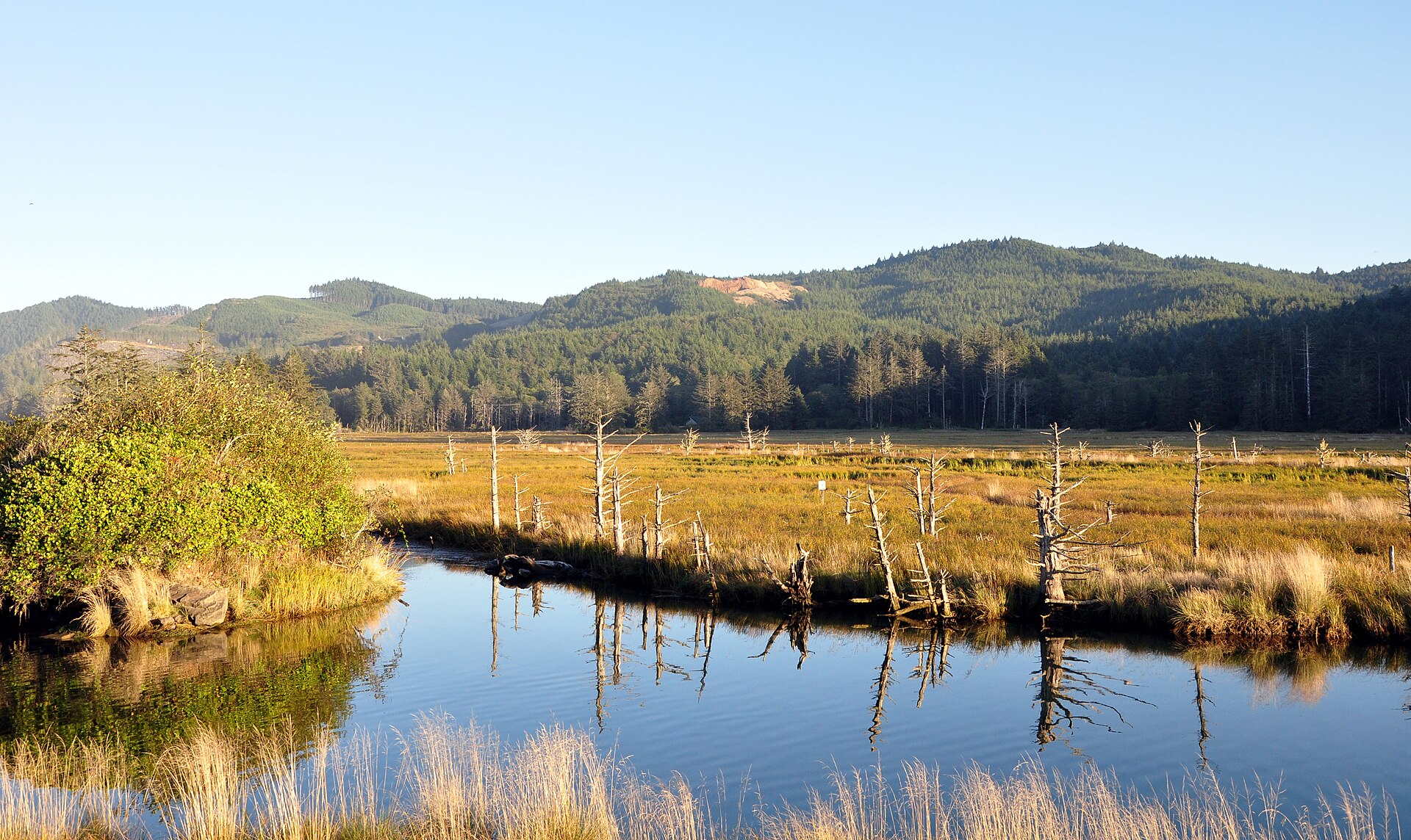
If Cascadia struck on a sunny summer weekend then 10,000 could die in Seaside, Oregon alone because of it’s unique geology. An early warning system will not be much good. Coastal residents will only have about 15 minutes or so from the time the earthquake hits and the tsunami arrives. The best coastal residents can do is to have a tsunami escape plan before the quake hits.
Fortunately, the State of Oregon has already done about all possible to help Oregonians prepare. It’s called the Oregon Resiliency Plan.
The Oregon Department of Mineral and Industries (DOGAMI), where Chris Goldfinger works and the DOGAMI team works, have created exceptionally detailed maps of the the entire Oregon coast tsunami danger zones.
From those detailed maps, the State of Oregon installed marked tsunami escape routes all along Oregon’s coast. The state also created an online tool that any coastal resident can enter their home address and it will build a customized escape route for them out of the danger zone.
Even 315 years later, the effects of the Great Cascadia Earthquake of 1700 are still apparent along Oregon/Washington coastal rivers and estuaries:
The dead snags seen in this picture are the remains of a coast forest that sank about 8 feet or so during that quake and got inundated by salt water, which both killed and preserved the trees. Called “ghost forests” these can be found all along the Oregon/Washington coasts.
I wrote an article about Cascadia a couple years ago. It’s titled “Cascadia: Day of Destiny”:
https://informthepundits.wordpress.com/2013/04/25/cascadia-day-of-destiny/
I think even a few minutes warning might save some lives.
The videos of the Japanese tsunami, taken by people who survived, were mostly created by people in strong, modern Earthquake resistant steel and concrete buildings. A lot of the people who died were driving their cars, or otherwise completely taken by surprise – some of the videos show people driving *towards* the tsunami, because they couldn’t see what was happening a few hundred yards ahead of them. The buildings the survivors were in – the tsunami and the debris mostly washed around them, leaving the people inside unharmed.
If I knew an Earthquake was about to hit, or had hit, and the tsunami was about to arrive, it would be nice to have a few minutes warning, so I could stop driving and find one of those Earthquake resistant buildings. It would also be nice if those Earthquake resistant buildings were easy to find – a bit sign out front saying “Earthquake safe house” or some such might help.
The early warning system is in place in Japan, and it works. You get the warning, then the shake. What happens is your cellphone rings with a unique tone, and you get a text message. I’ve heard it several times in the past few years, Thankfully we’ve had nothing as violent as the Tohoku earthquake in that time. That was scary.
After the Great Hanshin Earthquake, the building regulations were heavily revised. Many older multi story buildings were triangulated and braced. All newer public buildings are tied to the ground with pilings, and heavily steel reinforced. So, the city office, hospital, school or particularly school gym will be earthquake resistant up to about magnitude 8-9. Don’t know the exact figure. School gyms are important because they have plenty of space, toilets, showers, kitchens and tatami mats. They are dual purposed as evacuation centres.
Hector in Tohoku.
If this works, steel going into my local Junior High School gym
http://tinypic.com?ref=2ciic5k
[Link isn’t coming up. .mod]
Agreed, more warning time is better. The Pacific Northwest has a distinct disadvantage compared to Japan. It was built up believing there is very little earthquake threat there, let alone anything like Cascadia.
Scientists didn’t really start becoming aware of the Cascadia threat until the 1980s. By then most of the northwest’s infrastructure was already built, and none of it to earthquake standards. The State or Oregon was the first government to get serious about Cascadia and it’s plan didn’t come out until 2013!
I grew up in the Pacific Northwest. I was always told “The Big One” was gonna happen along California’s San Andreas fault and we had nothing to worry about. Little did the northwest know the real “Big One” is gonna hit them.
Good article azleader.
You’ve summarized and explained much better most of the points I was going to try and make.
A Cascadia earthquake is only the first strike of a very deadly two or three punch event. The following tsunamis and even aftershocks are the second and third punch stacking injury, death and physical destruction perhaps better phrased as utter devastation.
The tsunamis that washed over Sri Lanka were moderated by the flat terrain of Sri Lanka.
The tsunamis that will swamp the Oregon, Washington, British Columbia coasts will be multiplied by the shallow estuaries funneling up into heavily developed narrowing hilly river valleys.
Earthquake researchers digging up tsunamis deposits have documented tsunamis washing over the hills.
West Coast city plans for citizens to start walking towards high ground when the sirens sound; a tough escape plan if the ground is still undergoing aftershocks.
Now about those strato volcanoes all along the coast. Their lahars (global warmed melted glaciers, no doubt) would bring deadly danger from the allegedly ‘safe’ East.
God is trying to help in Seattle at least as the Tunnel project to permit US 99 to go underground the center of Seattle for circa 2 miles along the waterfront is (permanently?) stalled due to “technical difficulties” in a broken boring machine.
Dan Kurt
Very similar “ghost forests” can be found at high altitude lakes where they certainly did not sink 8 feet into salty brine. They are used extensively in tree ring drought studies. Sorry, the Cascadia subduction zone is a really, really wimpy subduction that has largely been translated to strike slip.

You can see slab descent in Benioff zones where the depths of hundreds of tiny earthquakes can be mapped as contour lines.
Here is the western Pacific:
Here is “Cascadia”:
We should certainly improve our earthquake/tsunami preparedness, but to equate the subduction earthquake potential in the Cascades with Japan, as is done in the New Yorker article, is just plain silly.
We should certainly improve our earthquake/tsunami preparedness, but to equate the subduction earthquake potential in the Cascades with Japan, as is done in the New Yorker article, is just plain silly.
Why? Your post didn’t really explain it. I live in Seattle and have read about and watched the documentary about the next big one. If this is overblown, I’d love to know about it. Please present your evidence.
To my mind I presented ample visual evidence. We can see subduction. We see it both in the Benioff zones I showed and from seismic tomography. Please look at the images carefully and compare Japan with Seattle.
Please don’t get me wrong. Seattle is at risk from tsunami. Everywhere coastal is. Crescent City California was devastated by a tsunami in 1964. That 9.2 earthquake was in ALASKA. Please look at the images again. For whatever reason Seattle pretty much got a pass.
My point is a response to somewhere in the beginning of the article where they say that the San Andreas is only capable of 8.something. Cascadia as well. There is virtually no subduction going on there. Furthermore, subduction thrust faults make way gnarlier tsunamis than San Andreas style lateral faults.
gym,
You are not current on this topic. Here is a place to start:
http://www.geodesy.cwu.edu/instruments/tilt/explanation_ETS.html
or here:
http://www.geodesy.cwu.edu/
Thank you. I’m aware of the array. I had not seen the vector data. I would say it is consistent with my contention that the subduction is transitioning to strike slip. What is really amazing is it suggests a rotation of the northern Great Basin and Columbia Plateau that is independent of the North American Craton.
We need a MUCH larger array.
Gym says “ There is virtually no subduction going on there.”
Mt. Baker, Mt. Rainier, Mt. St. Helens say otherwise.
The zone is locked and the crust above is bending like a diving board as the under sea crust sinks.
Stop writing and start reading.
Please learn to separate a tree from the forest. Your array is a microcosm. Put one in the west Pacific if you want to see a real subduction zone. You can’t just ignore the previous data that strongly suggest your microcosm is not representative.
There is some subduction going on. Possibly relict subduction. The slab appears broken off in tomography.
Please see http://www.unc.edu/~lswagner/publications/Wagner_Earth.Planet.Sci.Lett._2010.pdf
I have to agree with John F. Hultquist on this.
When a zone is moving it isn’t as much of a threat as when it is locked. That very very astoundingly naively short duration map of “subduction” can’t say much at all about what does, or does not, subduct on longer time scales (i.e. real geologic time).
Similar to the San Andreas. The parts that DO move are not where you get the really great quakes. The parts that are presently locked and have been for a few hundred years are where you wait to die.
The “evidence in the dirt” around Cascadia is darned clear. Great Quakes of about a size 9 happen, and with modest periodicity of the 300-500 year range. No ifs, ands, or buts. Get ready for it, or get dead from it.
That that plate is hung up right now, and has been for a 100 years+, is reason for grave concern.
That Japan has more steady creep in it’s side of the Pacific is why it hasn’t been destroyed (yet).
Whoa, why do I sense alarmism here. The Japanese +9.0 is proven. The Alaskan +9.0 threat is proven. The Cascadia +9.0 threat…not. Get used to it, the really big logarithmic scaled earthquakes happen in serious subduction zones. The tiny scrap of a plate being pushed by a relict ridge of Cascadia simply isn’t one of these.
Strain develops in all regimes. Strain is measured mightily along the San Andreas strike slip system. No pretense of understanding why, but the largest Richter scale earthquakes happen in real subduction zones.
Tsunamis are ocean sloshes. They are tides. Check out the videos of Japan. There was no Maverics style crashing wave. It was a tide that wouldn’t quit. If you want to slosh the ocean, subduction is way more efficient than strike slip.
In topography, closer lines represent steeper gradients.
Compared to Japan’s zone, Cascadia looks like a cliff; and Japan’s faults are not pussycats.
Nor would Mount McKinley and Mount Ranier and all their brethren be such monsters without a major subduction zone.
Ok, there is both “flat slab” and the more iconic 45 degree textbook subduction. There is tomographic evidence of both, but flat slab is far better supported by the evidence at hand. When you are jamming basaltic ocean floor under inherently more buoyant granite and serpentine continents at relatively high speed you get flat slab. That’s Japan. Just look at the plate vectors. The Pacific ocean floor west if the rise is currently moving obliquely away from North America and towards Eurasia.
Mt. McKinley is a completely different animal than Mt. Rainier.
It’s true there are ghost forests created in other ways. That is NOT the case of the ones on the Washington/Oregon coasts. In fact, their discovery by UW scientist Brian Atwood in the 1980s was the first hard evidence of the Cascadia threat. Atwater had noticed a similar phenomena happened in Alaska after the Prince Williams Sound 9.2 mega-quake of 1964, then looked similar occurrences in in the Pacific Northwest.
Chris Goldfinger and others found turbidite evidence in sea floor sediments documenting 41 total Cascadia mega-quakes over the last 10,000 years:
http://www.pbase.com/azleader/image/149810639.png
The New Yorker didn’t get all their facts right, especially about Seattle, but they did not exaggerate the threat. It’s very real. There is a 37% chance another Cascadia will happen in the next 50 years. When it strikes, it will indeed be the largest natural disaster to strike the continental United States.
Statistics is rolling dice. I’m inclined with good company that God does not play dice. At least with dice the outcome is constrained by moments as they leave the hand, angles of incidence with the impact surface, and the shapes of the die.
When you say there is a 37% chance in the next fifty years of another of the 41 historic quakes, what are the parameters? How, exactly do turbidite flows gauge earthquake severity as opposed to sediment instability?
“Statistics is rolling dice”
Not really. Statistics is doing science and collecting data. You take what you know and create “loaded dice”. Then you roll them to randomize the unknowns while quantifying the knowns.
In most of the country, to get a 8.0 earthquake, you have to roll two dice and get a total of 13.
Loading dice does not randomize the unknowns. It merely validates your preconception.
The Pacific coast of North America is a very dangerous place for earthquakes. A mid 8 is possible anywhere along the margin. It would wreak so much havoc nobody would even care if there was a tsunami. But please don’t ignore the New Madrid fault in the heartland. I think many would agree you could roll two dice and get a 13 there.
You only need to roll snake eyes to get an 8.0 on New Madrid, Charleston, or the west coast.
Portland has been my home for many years but the worst earthQ I ever rode out was 5.9 in Virginia of all places… That was really freaky… and the odds on that were probably rolling snake eyes twice in a row.
It’s ironic, gymnosperm, that you should chose Einstein’s famous “God does not play dice with the universe” statement as the basis for dissing the 37% probability. Einstein used it to discredit quantum theory, the other great physics theory of last century, which is inherently statistically based. He never accepted quantum theory because of that and he was wrong.
Your questions about the 37% and the turbidite evidence supporting it are found in this lengthy, detailed paper first authored by Chris Goldfinger:
http://pubs.usgs.gov/pp/pp1661f/pp1661f_text.pdf
That paper was summarized in the British journal Nature here:
http://www.nature.com/news/2010/100531/full/news.2010.270.html
Irony intended. Einstein did not reject quantum. He worked closely with Bohr on the quanta of electron states and fully agreed. They parted ways over the post quantum perversion of elevating statistics to the stature of a force of nature. You can say Einstein was wrong. I humbly agree with him. Statistics is whitewash for what we do not understand, earthquakes equally with quantum superposition etc.
Anyway, thanks for the links.We WILL be whacked by a big earthquake and it will be a holocaust whether it be in LA, SF, of Cascadia. My only point in all of this is that the Cascadia drama seems excessive.
“Statistics is whitewash for what we do not understand”
Statistics don’t improve science, but I would argue that statistics enable you to maximize the operational use of scientific knowledge.
We don’t know for certain if it will rain or not, but if you develop stats for sharpness and reliability, knowing whether the POPs are 2% or 88% makes a big difference in the operational value of meteorological knowledge.
Can you tell I work for a statistics operation ?
I can tell that you are a philosopher. If you work for a statistics operation, thank goodness. Statistics is in dire need of your philosophy. I completely agree with your argument above.
Still keeping the 37% chance of Cascadia cataclysm under advisement. Time is short and work is long. You are the statistician. What do you think?
I don’t know squat about forecasting earthquakes. But I’ve forecast just about anything else….one year here at work, most of our company profit came from forecasting American Idol eliminations. Not kidding.
What makes me furious about climate change is the lack of accountability of forecasts. They are so far in the future and have no statistical cross-check. Now that we have a quarter century of verification, the results aren’t pretty. Statistically, about 40% of the warming forecast seems justified, the rest is model bias. But there are so few forecast cases, stats really can’t tell the story. Weather models were originally terrible but after zillions of cases, the statistics identified the problems which were then addressed. Now the weather models still have numerous flaws that are statistically corrected. Climate models do not…and will not… have the robust verification database that could lead to model improvements. There just aren’t enough independent cases.
Interesting article. My response is too long to put here and requires a lot of explanation so I’ve posted it on my blog: Could global warming be delaying the “Big one” earthquake (re WUWT)
Summary: In short, increasing temperatures could be delaying “the big one”.
There is a paper currently undergoing peer review that analyses the correlation between the solar magnetic cycles, their relative strength and polarity, and earthquakes of M8 or greater in magnitude.
Assuming that the sun does in fact have some geo-effective influence on large earthquakes (which this paper strongly suggests) then there is perhaps some mechanism whereby a period of strong solar activity reduces the occurrence of large earthquakes in the Pacific North-West of the continental United States.
There are other papers that are currently being written which investigate the correlation between strong pressure systems and earthquake activity associated with them. These papers treat pressure systems as electromagnetic interactions (coined “earthspots”, as per their solar counterpart, sunspots), and view earthquakes through an electromagnetic lens.
If either (or both) of these hypotheses, which are in their infancy, prove to be true, then perhaps the warm temperatures experienced by the Pacific North-West correlate with reduced major earthquake activity. Though in either of these cases the warmth correlates with, rather than is the cause of, this phenomena.
“Correlation does not imply causation”. I remember an article in Science Digest in the 1970s that warned that the Grand Alignment of all the outer planets would cause extreme weather events which would cause The Big One on the San Andreas. Didn’t happen.
I agree entirely. But correlation is a good starting point for investigating whether or not causation is there as well, no?
I mean, correlation does not imply causation. But causation demands correlation – so the latter is the right place to start looking.
I don’t have a problem with correlation studies. Once you know that there’s a good chance that observable phenomena are linked, you have to supply a falsifiable hypothesis before you proceed to study causation. Exactly how do sunspots supply the extra strain energy necessary to start a rupture in a fault? I’m coming up blank on that question.
Och, aye. An’ Ah could hae haggis forrr brrreakfast. But Ah’m not.
Eric wrote: “The last time the Cascadia fault produced a major Earthquake was in 1700, and there is evidence of 41 similar events occurring roughly every 240 years, stretching back over the last 10,000 years, so there is strong historical evidence that this is a real and present danger to the citizens of the American Northwest. The next Earthquake is at least 60 years overdue.”
Many of the events involved only a partial rupture of the Cascade fault and weren’t as strong as the one in 1700. A weaker earthquake is “overdue”. Seismologists estimate a 15% chance of a full rupture within 50 years, producing an earthquake and tsunami similar to Tohoku in Japan in 2011.
You are right, a weaker event is expected next time, but a “weaker” Cascadia is 8.7 or 8.8 and would still be the largest earthquake to strike the continental United States. Of the 41 events, the Cascadia of 1700 was rated “medium”.
A partial Cascadia begins down at the Mendocino Triple Junction and rips northward some distance, but not all the way up to the Seattle/Vancouver BC areas. They would be less affected than by a full rupture Cascadia event. Liquifaction, of course, can occur great distances away, like happens in Mexico City, depending on geology.
Just what are people supposed to do with this information? Be scared?
Demand your government install a Japanese style early warning system might be a good start.
Eric,
Two thoughts. Use Google Earth or some such and look at the city of Ocean Shores, WA. When you have 15 minutes to evacuate this place the only way to go is up. Helium balloons being a good option.
Thought two: build a mound.
http://www.emergencymgmt.com/disaster/Washington-County-Plans-Vertical-Evacuation-Tsunami-Building.html
An early warning system would be of help, but nothing will stand in the way of Cascadia; just as nothing stood in the way for Japan in 2011 with all it’s massive earthquake preparedness.
The best the Pacific Northwest can do is start a long-term and very expensive project to require all new major structures west of the Cascade Mountains be EQ resistant to 9.0 and that existing buildings and critical infrastructure retrofitted to that same standard.
It would be a great economic boom to the construction business. 🙂
“but nothing will stand in the way of Cascadia; just as nothing stood in the way for Japan in 2011 with all it’s massive earthquake preparedness. ”
Japan was prepared and 16,000 people died. During the Boxing Day Tsunami of 2004, most people had no preparation and no warning. 230,000 people died.
Preparations make a huge difference.
Mary Brown…
You are absolutely correct, preparation makes all the difference in the world!
That’s why the State of Oregon is to be commended for accurately identifying all the tsunami zones in great detail along its coast and marking their escape routes. That, no doubt, will save many lives in that state. Other places should do the same thing. Every coastal resident should pay attention and be aware of their escape routes if they are in an affected area. That’s about as good as you can do for a tsunami. I don’t think there is any such thing as tsunami-proofing structures.
It will be harder to convince people away from the tsunami zones to expensively prepare for a hidden danger that hasn’t happened in hundreds of years and may not happen for hundreds more.
…live on the moon. No global warming, few earthquakes if any, no toxic CO2, no polar ice, no oceans rising, no catastrophic stuff, and no politicians…to date.
Have an earthquake kit outside the house, if possible.
…if a full rupture Earthquake strikes, everything West of Interstate 5 will be “toast”
This statement appears to be from an unnamed FEMA official. Anybody know who said it, and on what basis? It certainly wouldn’t be from the tsunami; there are whole mountain ranges between I-5 and the coast..
I read a good part of the USGS document that led to the “toast” conclusion. The conclusion arises out of the consequence of the earthquake, not the quake itself. If memory serves, the estimate was over 60% of bridges would be unusable. The USGS document stated that together with landslides, re-directed rivers and streams, power outage, shattered water and gas distribution, those living east of the I-5 would be on their own for between one and three months before services could be restored (priority would be given to the major population centers). The community groups that heard this presentation agreed that the ‘toast’ comment was an accurate summary of what it would mean if even a small town if they had to ‘live off the land’ for a month. The effect on a medium sized city are the stuff of horror flicks.
For the record, that’s west and not east of I-5. I was born and raised on the west side of I-5 and most of my relatives and friends still live there.
That snagged my eye, too. It looks to me like the closest the official in charge of the area has been to the NW is West Virginia. Whoever said that hasn’t clue one what the area actually looks like.
Probably someone talking about liquifaction near the Seattle waterfront was taken out of context. Yes, there will be a lot of damage, West of I-5, in Seattle, when a major quake hits.
Liquifaction caused the most damage during Alaska’s 9.2 Prince Williams Sound mega-quake. Anchorage is about 80 miles west of the epicenter of that quake and it did this: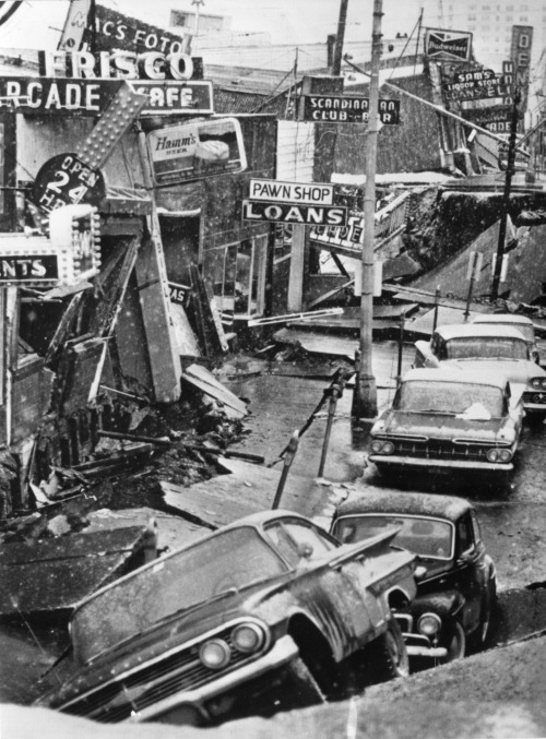
and
http://alabamaquake.com/Images/Earthquake%20Alaska%201964%20Damage%205.jpg
and this
http://guardianlv.com/wp-content/uploads/2014/03/buildings_falling_down-e-a-1964.jpg
My home town of Salem, Oregon is about 80 miles east of the Cascadia fault and is smack dab in the middle of one of the Willamette Valley’s many liquifaction zones.
Literary license?
~~~~~~
Go to Aberdeen, WA using Google Earth.
Zoom out. Look for —
Ocean Shores, Westport, Grayland, Raymond, Ocean Park, Long Beach
My friend in Bellingham sent me this – north of Seattle:
ger_ofr2004-15_tsunami_hazard_bellingham
Here’s a better link – they say that the frequency is approximately every 600 years:
http://wa-dnr.s3.amazonaws.com/Publications/ger_ofr2004-15_tsunami_hazard_bellingham.pdf
Here is a timeline graphic from the Oregon Resiliency Report:
http://www.pbase.com/azleader/image/149810639.png
That report was prepared by the State of Oregon as part of it’s preparedness plan for the next Cascadia event.
“…if a full rupture Earthquake strikes, everything West of Interstate 5 will be “toast”
That is an exaggeration by the New Yorker, as most of the land west of I-5 is well above sea level…
Depending on how you define “toast”, The New Yorker may or may not be right. They got much of their stats from the Oregon Resiliency Plan completed in 2013.
For west of the Cascade Range in Oregon alone, the report forecasts:
* Earthquake deaths: 650-5,000
* Tsunami deaths 600- 5,000
* 24,000 buildings completely destroyed
* 85,000 buildings with extensive damage requiring months to years of repair.
* Approximately $32 billion in economic losses.
* 27,600 displaced households.
* 1-3 years to restore drinking water and sewer to coastal communities
* 1 month to 1 year to restore water and sewer to the “safe” Willamette Valley (55 miles inland)
* 6-12 months to restore partial function to top-priority highways in the Willamette Valley (like I-5)
* 2-4 months to restore police and fire services in the Willamette Valley
* 18 month to restore healthcare facilities in the Willamette Valley
* 3 years or more to restore healthcare facilities on the coast
* 1-3 months to restore electricity in the Willamette Valley
* 3-6 months to restore electricity to the coast
* Almost 10 million tons of debris (1 million dump truck loads)
Some folks might call that “toast”. What do you think??
I think that “toast” implies much more extensive damage than perhaps 1% of buildings being destroyed.
Seems to me that what will happen will be bad enough that there is no need to exaggerate.
Toast or not, I have a great place tucked way into NE Oregon for my entire I-5 family (kids, adults, even the ex and whoever he brings, animals, and whatever else) to hide out safe and sound till it is safe to return to their homes. I’ll even go get them. And if I am dead and gone by then, they will still have this place if they are smart enough to keep it instead of selling it.
I’ve been in an earthquake that shook us right out of bed in Albany, Oregon. And it was a mild one! I have crawled around the Cascades and observed the awesome power of that Cascadia Zone. I do not doubt that a quake in that zone (which is not sliding, it is subducting) will be devastating.
Toast or not, an 8+ earthquake will be devastating. Part of the issue — never mentioned in these stories or documentaries — is that the areas west of the Cascades (with a population of 7+ million) are geographically much more isolated than people realize.
Here in Seattle, there are only a few major roads. I-5 and I-90 are almost certainly going to be blocked, and the two or three secondary, two-lane roads will be blocked. Getting supplies in here is going to be an undertaking of gargantuan proportions, especially considering how many people live here now.
Also in Seattle, and Portland, there are a LOT of buildings that don’t conform to earthquake codes, which themselves are recent. The relatively mild Nisqually earthquake of 2001, magnitude 6.8, did $13,000 worth of damage to my house, much of it barely visible. If they’re right about an 8+ quake here, this is going to be a bigger disaster than most people know. In particular, much of downtown Seattle is built on loose fill, and there are some other big areas of the city that will be in big trouble.
I think you are somewhat light in your timing figures.
In Christchurch NZ, several major things happened that were more disastrous that the earthquakes themselves.
1. The insurance companies became cash strapped and found excuses not to pay out.
2. Insurance companies refuse Building Insurance for more than two years after the final quake.
3 The government got involved and tried to “Help”.
4. The government decided to not to just clean up but instead decided to use this “Unprecedented Opportunity” to rebuild Christchurch as a brand new sustainable and carbon emission free city.
Result after almost 5 years:-
1. The government compulsorily bought up, (read ripped off), CBD and other properties at rock bottom “earthquake prices” in order to implement 3 above.
2. CBD is still being “rebuilt” and private owners and investors have largely moved out.
3.The local government has run out of cash and is politically unable so far to tap into the NZ$1 Billion assets it holds in order to be able to complete the infrastructure repairs.
4. Roads have been dug up as many as three times in order to attempt the above mentioned infrastructure repairs.
5. CBD Businesses that survived the government intervention, (andhave stayed in the area) have relocated out to the suburbs and seem unlikely to come back to the CBD.
6. Worst of all, after nearly 5 years, some citizens are still waiting for their insurance payouts which means they are either still living in the garage or are paying both a rent or mortgage.
7.Riverbanks have been cleared in order to comply with Agenda 21 (Water sustainability doctrine) although a few in those areas whose properties were NOT damaged significantly are holding out in spite of the threatened and progressive removal of utilities.
8. There is a group legal action being assembled at the moment to try and get a certain major insurer to actually pay out.
And so on.
There is some commentary on this in my blog http://www.thedemiseofchristchurch.com
Cheers
Roger
[CBD is Christchurch B ?? Downtown ?? .mod]
CBD =Central Business District.
Cheers
Roger
Pamela Grey…
I bet you are referring to the 5.6 1993 Scott’s Mills earthquake. I and my family in Salem were jolted out of upstairs bedrooms, too. I remember seeing the trees shaking after running into the back yard. It was later discovered that if the shaking had lasted 20 more seconds that the dome of the Oregon State Capital, a mile from my house, would have collapsed. That would have made headlines. As it was, it took five years to repair the damage and reopen the building.
Mike M…
According to the State of Oregon commissioned Oregon Resiliency Report, 109,000 structures will be destroyed (24,000) or extensively damaged, taking months to years for repairs. That’s just for Oregon. That doesn’t include northern California, Washington State or British Columbia.
That might not sound like much to you, but don’t tell that to affected Oregonians.
I-5 run right next to the Puget Sound on a hill side all the way from Tacoma through Seattle. Even the 6.8 quake we had years ago caused a lot of damage and liquification in that area, along with mudslides. A big quake would very much “toast” all the area west of I-5 along that corridor.
Okay, then how about everything west of I-5 will be jelly?
Not only that, I-5 bisects all the cities, including Portland, Tacoma, and Seattle, and is roughly 200 miles east of the fault. To suggest that Queen Anne will be ‘toast’ and Capitol Hill will be fine is ridiculous. The cities will be pretty uniformly impacted, and I-5 is completely irrelevant.
In an otherwise excellent and chilling article – the author HAD to insert this remark to establish her self-loathing bonafides: “It does not speak well of European-Americans that such stories counted as evidence for a proposition only after that proposition had been proved.” I’d love her to give ONE example of ANYTHING that “speaks well” of the people that explored and settled this great and prosperous land.
And folks! In my above comment I’m referencing the author of the New Yorker article linked to an this very informative post.
Find and read the article by Tom Wolfe about former editor of The New Yorker William Shawn TINY MUMMIES if you want to understand articles in the New Yorker.
Dan Kurt
Microsoft would be flooded, which will be an issue, especially as we have our oldest working there. Yet another reason to scout out that escape route to Canada through the mountains.
Don’t worry – they’ve preserved it in MInecraft
Would that end the GWX alert?
Do you have any idea where Redmond is?
I can’t seem to find it, but there is an island off the West coast of Africa, that if it splits, and it will do one day, will cause a tsunami that will destroy large sections of the east coast of America.
That would be the Canary Islands, or specifically a volcano on the island: La Palma. This appears to be the original paper: //w…geo.arizona.edu/~andyf/LaPalma/Rift%20Zone.pdf … There is also an article: “Tidal wave threat ‘over-hyped’ ” .. “The risk of a landslide in the Canary Islands causing a tidal wave (tsunami) able to devastate America’s east coast is vastly overstated. That is the view of marine geologists studying ancient landslides in the area. In typical Canary Island landslides, chunks of land break off in bits, not in one dramatic plunge, they argue.” //newsvote.bbc.co.uk/mpapps/pagetools/print/news.bbc.co.uk/2/hi/science/nature/3963563.stm
Patrick, you mean La Palma. If it ever did split, it would be game over for Eastern US, and many countries.
Interesting articles on Cumbre Vieja
http://www.theregister.co.uk/2015/02/17/bbc_trust_oks_hollywood_disaster_factuals/
“America”… Do you mean North America or only the U.S, the tsunami stopping right at the border with Canada? Self-centric USA is at it again.
ho hum
Aalto university helps Quileute nation relocate after whales warn of impending tsunami.
http://gradsage.com/2015/04/15/aalto-university-helps-quileute-nation-relocate-after-whales-warn-of-impending-tsunami/
Now that prediction I find more unnerving than any by Hansen, Gavin, gore,…
Though getting their new residences designed and built for them does reek of taking advantage of the gullible.
“Being a petroleum geophysicist, I prefer the explanation that S&G [Soddom and Gomorrah] went up in flames from a natural gas leak via fault rupture, ignited by open flame and fires. I can’t explain the pillar of salt. But the fireball has an all too real source.”
I can explain the pillar of salt: currency. Salt poured into small deep holes, dissolved into solution, compressed with heavy poles, let dry then lifted out of the ground as a crystalline “pillar” — was a densest and preferred method for transport. Salt pillars were ingots of desert currency.
I believe Lot sold his wife into slavery and the pillar was payment. Perhaps he did it because he had an incestuous relationship with his daughters, which was amply documented (and their progeny clumsily explained) in a later chapter. Perhaps the wife — whose actual name was scrubbed from the record by the same re-write committee — merely did not approve.
So, turned in for a pillar of salt, not into one?
Typed my email address wrong.
Earthquakes are notoriously bad at time keeping and we are notoriously bad at reality preparation. The wastage of monies on crap climate research would be better spent on increasing earthquake knowledge and mitigation.
The article states that …”because the Richter scale is logarithmic,” a Richter 8.2 quake is “six per cent as strong as the 2011 event in Japan,” which was 9.0. Well, 10^9 / 10^8.2 = 6.31, so the 8.2 quake would be 1 / 6.31 or ~15.8% the strength of a 9.0 quake.
PS: I suspect this was the error of the author of the piece, and not the author of the study, Chris Goldfinger.
Greg;
That isn’t following the Richter logarithmic scale properly.
Translated, a 9.0 earthquake is 31 times more powerful than a 8.0 earthquake; your multiplication factor of ten is not correct for estimating differences of earthquake energy.
Regarding the ‘pillar of salt’, consider these remarkable photos of calcified animals by Lake Natron in Tanzania.
http://www.huffingtonpost.com/2013/10/03/calcified-animals_n_4032659.html
I’m no geologist, but perhaps in the aftermath of an earthquake, something similar might have occurred at the edge of the Dead Sea, and Lot’s wife could have been one of those unfortunate enough to be caught up in it ?
Those photos are stunning. I have no trouble believing the account of Lot’s wife in the Bible, but it is interesting to hear your conjectural reconstruction of the cause.
See response resources on the Cascadia fault, especially the
Cascadia Region Earthquake Workgroup
http://www.crew.org/
I attended a civil defense special conference in Ashland, Oregon in 2000. We were told that because a magnitude 9 earthquake along the Cascadia subduction zone would affect two major metropolitan areas at once, small towns in western Oregon and Washington should plan to be without outside aid for as long as six months. I live on far more stable crust now.
small towns in western Oregon and Washington should plan to be without outside aid for as long as six months.
Um, what? You mean the rest of the country is just going to sit there and stare at them?
Roads and railways destroyed; ditto electrical lines, water, sewage pipes, etc. Triage would come into play. Evacuation would be the only option after a big tsunami..
“Without outside aid” is a pretty specific phrase. I read that as “no one is going to help you for as long as six months” which is simply not true in any realistic scenario.
Eustace Cranch
Last Sunday afternoon, a simple rain storm washed out a important bridge on I-10 near Desert Center, CA. Note the disruption it is causing interstate movement and the time frame for it’s repair. Now imagine every bridge and overpass damaged. Also due to steep hills and mountain sides, you will have landslides destroying roads.The list goes on. A lot will depend on the epicenter and focus of the event. Remember the tip of the Pacific plate extends all the way to (subterranean) the I-5 corridor in Oregon. Yeah, people will be cut off and on their own for quite sometime. There are only so many helicopters and so much fuel for them. It will be a bear getting any supplies in with so much of the infrastructure crippled. The big cites will more desperately need the first pulses of help that come available.
michael
I have no doubt of the 6 month timeline. At least in Oregon, it is peppered with tiny towns that will all but disappear amid a changed landscape who’s landmarks will have substantially changed, making it difficult to locate where the town USED to be. There are also single family houses built well within and hidden from view in a 100’s of acre landtrack that will be extremely hard to locate. Plus survivors will need to seek substantial shelter that may hide their heat trace to overflights. So yes, prepare for 6 months of no help from anybody.
I’m guessing you are too young to remember Katrina. They worked every angle possible to get the death toll for that to an even 1000, so it would seem worse than it was, and there are parts of the region that are still impacted. I spent a lot of time there helping family with the cleanup, and it was a couple of years before things got back to normal for much of the city and surrounding areas.
That was trivial compared to a 9.0 on the Cascadia, or the New Madrid fault, which is also overdue. And NOLA and Mississippi are very centrally located compared to the Pacific Northwest. Six months without any significant reconstruction or restoration of critical services is utterly within reason.
Think “Continuity of Government.” Certain agencies have 10,000’s of gallons of underground fuel, multiple megawatt generators, etc… They have agreements with fuel and energy resources to be first…period. Everyone else is last in that department. That includes food and water. Those on public water and public everything are slaves to that system. On the west coast of Oregon and Washington a simple snow storm or wind storm puts folks out of power for weeks with all the fallen trees, blown transformers, etc. Now imagine having to depend on someone else when your name is on the “Z” list. Put your droid and ipad away…it won’t work without power to the towers they depend on.
I’d plan on a year. The folks I talk with say the parts to repair our power grid simply are not available, that they are a year or two away. After 9/11 we purchased a “large” chunk of land…with all the comforts except the grid. It has a runway, no roads. I see others doing the same in remote areas. I suggest you make friends with Pamela Grey…or at least emulate her, she too has well conceived plan. (see her post)
It will stretch all possible help just to respond to the metro areas. The civil defense people were trying to impress upon everyone the reality of the situation. A magnitude 9.0 earthquake on a fault such as the Cascadia is not just a tsunami. It is the equivalent of the 1960 Chilean earthquake, but in a heavily populated region–the earthquake will impact everything a long way inland. It would be a trillion dollar event.
Yes, the rest of the country will just sit there staring at their TV screens. It’s what we do.
As per the notion that an army of helicopters will swoop in with everything needed:
Not going to happen. Just not enough transport available. Look at the massive quantity of goods going in to that region from ships, trains, and heavy trucks. Couldn’t get 1% of that onto choppers.
Now realize that all the distribution is taken out as well. Warehouses. Refrigeration. Fueling facilities. Electric power. Networking and communications.
Trying to recover that mess will take at least 6 months IFF you are very lucky.
Sometime after that TPTB might start to care about the 2000 person town next to a small creek with steep hillsides on each side, with no “H” pad anywhere near… For those folks, they are, and always have been, on their own.
Washington State has a population of 7 million. US Army is presently just under 1/2 million world wide. That’s 14 people per US Army staff. Now figure many are overseas and not available. We will not be emptying out the Pentagon and Fort Benning. Etc. etc. Now add in the population of Oregon. You will end up with about 100 to 200 people per “boot on the ground” IFF you are lucky. Most of them in big cities. The “bang for the buck” leverage will be those big cities (getting expedient ports working, putting in ersatz bridges, getting airports functional, etc.).
It’s simple rational triage. Start at the “ports of entry” and along “communications and transport” lines and build back out. That means big cities first. (Even inside that, you start with hospitals, command and control, infrastructure and support – like fuel depots, food distribution, … not with Aunt Mable 20 miles after Old Joe’s barn)
Now Cascadia will be a whole ‘nother animal. First off, it will be off coast and below the ocean. Tsunami will be astounding. A 10 footer took out Crescent City. This will be about 100 foot. It’s a long fault running consistently just off shore of a bunch of major population and infrastructure centers. Basically, it wipes out the best and most important bits. Most all of the major services run North / South along that line. Roads. Rail. Pipelines. Telco. That’s where the nice easy to build valleys run… and near the water ’cause folks love a water front property.
Essentially, Bend will become the new capitol of Oregon until Portland can be recovered. A mass exodus inland will need to happen also until that can be done. Look at this “heat map” of population density for Washington State:
https://data.wa.gov/Demographics/heat-map-population-density/exfi-4bxp
Now ask yourself: You are sitting in D.C. and dispatching “aid”, where do you send it? To that giant glowing blob near the water and where shaking was the worst? Or to Kennewick? How about the small spot that doesn’t even show up on that map due south of the Seattle Blob.
You won’t even know that small town exists for the next 3 months as every moment of your attention will be on the Big Blob and the news reports sending out broadcasts from it.
My credentials on this:
Loma Prieta quake – Manager In Charge when it happened. Ran shutdown and recovery for the Supercomputer Center at Apple Computer. All of Apple took 3 days off before even starting to think about it. (Other than a couple of brave souls – mostly single IIRC – who stayed behind as minders).
Drove 20 miles from Apple to get home post-quake and post-building clearance. It took HOURS, and that was with minimal damage and no bridges out along my route as we were away from the epicenter. It was a good week before things were back to anything near normal. NO traffic lights working and everyone driving at once brought things to a crawl even where intact. It was worse where there was real surface damage.
At no time was any “disaster relief” seen. (Not like I needed it, but you would think it was wall to wall Red Cross and it was mostly Red Cross begging money on the Satellite TV…)
UC classes in geology of quakes and natural hazards.
Produced Hurricane Disaster Recovery documents and did D.R. Exercises for Disney on contract. Yeah, I was one of the “D.R. Guys” for about 18 months.
Lifelong interest in “preparedness”, with full quake kits. Partial use in 7 scale event (‘partial’ as I’d used USGS maps in choosing where to buy a home… low shake zone). My interest started from several floods when I was growing up.
So it’s not like I don’t have some background in Disaster Recovery… In California, the general rule of thumb is that if you are not “50 miles inland” from the major faults, you need to be prepared to be entirely on your own for one week. Cascadia will be orders of magnitude worse, mostly from the tsunami.
E.M. Smith…
For the record, Salem – not Portland – is the capital of Oregon, as implied by your comment. It’s my home town so I should know. 😉
I doubt Bend would become the defacto capitol of Oregon, but it will be in a lot better shape than major population centers west of it. Even though Portland is 75 miles inland, there still will be sea freighter access to the metro area from the west and river/I-84 access from the east. There aren’t a lot of bridges on the Columbia west of Portland so clearing that channel of bridge collapses, like the Astoria-Megler Bridge should it collapse, will likely be a high priority.
E.M.Smith
July 22, 2015 at 3:23 pm
There are almost as many members of the National Guard as of the Active Army, plus over 200K in the Reserves.
It’s also possible to deploy Marines, sailors, airmen and Coast Guardsmen in emergencies, along with federal law enforcement personnel. OR and WA also have emergency preparedness fusion centers involving state and local police, plus selected individuals with useful skills and experience.
Chinook helicopters are not abundant, however. OR and WA NG each have eight, as do most states. Rarely are two operational at any one time. The Active Army also has some, of course. Most of the now 12 (I think) Combat Aviation Brigades have 12 each. Upgraded CH-47F-models are being delivered by Boeing now. Some of both Guard and Active Chinooks are still deployed overseas.
The army has Chinook helicopters. I imagine in the cities there would be troops and marshal law. Not pretty, but better than riots and anarchy.
Gosh. What if all those millions of tax and spend progressives now living in cities from San Francisco to Seattle try to relocate? They’ll turn everywhere else in the west into “Portlandia.” OMG!
They will expect the US to spend “other peoples’ money” on them. I sure hope there’s some left by the time this happens. Doubtful, that.
A rather less hysterical view of the New Yorker article was recently published in Slate:
http://www.slate.com/articles/health_and_science/science/2015/07/kathryn_schulz_s_new_yorker_story_on_pacific_northwest_earthquake_geologists.html
Early warning systems for tsunamis are a good idea. I suspect we’re jumping the gun a bit regarding such systems for earthquakes.
I idea that Seattle will be devastated by a tsunami is a bit far-fetched, given its location in Puget Sound.
Seattle is at sea level. How is being in Puget Sound at sea level and getting devastated far fetched?
Any sizable tsunami would roll through the sound and spread the devastation beyond imagination.
I think Bellingham may be at great risk from a local T.V. program I saw on the subject, but Seattle itself would have the effects filtered by the Puget Sound and the corner the tidal wave would have to turn at the end of the Strait of Juan De Fucca (sp???). As I recall the depth of the water level would be maybe +3? feet in Elliot Bay (don’t quate me on this).
The tsumani won’t reach Seattle, but the shaking will.
Diffraction, destructive interference and outright breaking surf across the several reefs and shoals inbound .,.. seriously doubt inner Sound areas would get the full brunt. But the surge events would be moderately damaging, look at the footage from some of the West Coast small harbors on the open coast from the 2011 Tsunami to get a feel.
The more likely problem will be a collapse of portions of Mt. Rainier and the resulting lahar, which should wipe out Tacoma.
“I (think the) idea that Seattle will be devastated by a tsunami is a bit far-fetched, given its location in Puget Sound.”
Lake Washington has had periods of being salt water, progressing to brackish, and then back to fresh water again for as far back as they can get core samples. On top of that, if you core drill the eastern shore of the lake, you will find layers of soil and sediment filled with things that only grow out on the Puget Sound’s saltwater shore.
Look at a terrain map, and then tell me that the odds of Seattle getting hit by a tsunami are far-fetched. Assuming that those core samples and so forth are not the products of error, something happened that allowed Lake Washington to develop those features. My money is on “tsunami”, along with a bunch of folks who know more than I do. I spoke with a hydrologist who worked for the Army Corps of Engineers, and he claimed to have modeled the effects of a major tsunami coming down the Sound from the faults up around the Straits of Juan de Fuca. Per that conversation with him, the island features in the Sound are just about perfect for causing refraction waves that wash over the Seattle city site with great force.
There’s a reason that the only major civilization that got going here in the Americas was in Central America. Everywhere else gets whacked periodically. If it’s not the earthquakes, it is the volcanoes, or the droughts. The so-called “Potlatch Cultures” of the Puget Sound region start to make a whole lot more sense, once you realize that the locals were merely adapted to the periodic resetting of the clock, so to speak. Why the hell not “eat, drink, and be merry…”, when you could count on Mother Nature sweeping whatever you built into oblivion every few hundred years?
Here in the PNW there is no secret about the earthquakes we get around here. They are strong, but infrequent. When I moved up here they had just had one – and they said that these things happen every twenty years. It is a bit past that now…
When I bought my house about twenty years ago, real estate agents had maps of the geologic underpinnings of neighborhoods. It was easy to see that the areas with sedimentary or landfill underpinnings were mostly the lower priced neighborhoods. I bought my house on solid rock. It cost me more, as these things usually do.
Now the people who bought their homes on unstable ground expect me to pay for their danger they are in, but they never bring up the savings they realize every month when they pay their mortgage. Not everyone can afford to live where I do, I guess, but I think the matter is more about never taking these things into account in the first place. An ounce of prevention is worth a pound of cure.
I have heard that the really dangerous area in Seattle is along Elliot Bay due to the landfill in the early days to create someplace to build. That is pretty expensive real estate there, but it will be payback in a perverse sort of way for forcing the population to waste billions to put the Viaduct underground, so, that their view of Elliot Bay would not be cluttered by cars and a freeway (main throughfare).
It would be hard to overestimate just how bad a job local and state government does here. Come a big earthquake or eruption of one of the local volcanoes (Rainier is the most widely famous, but Glacier and Baker — just as close — are considered more likely to erupt, for whatever that’s worth), the response will be materially degraded by the rank incompetence at every level of government here.
I can’t believe they aren’t blaming this on Global Warming yet.
At what point will WUWT realize things routinely tagged as “Claim:” in the title actually should be tagged “Science:” ?
When “scientists” stop lying.
Bingo!
Not to try and minimize the San Andreas risks, but the New Madrid fault poses as much or more danger to the southern Mississippi river valley due to the possibility of interrupting the river’s course and flow. the long term effects could be devastating on the food, coal and oil transportation.
http://www.infowars.com/why-is-wal-mart-preparing-for-a-major-earthquake-on-the-new-madrid-fault/
This fault has a higher magnitude potential.
http://www.semissourian.com/story/2169312.html
Come on the claim is not new as opposed to the writer.
“Kathryn Schulz joined The New Yorker as a staff writer in 2015. Previously, she was the book critic for New York, the editor of the environmental magazine Grist, and a reporter and editor at the Santiago Times. She was a 2004 recipient of the Pew Fellowship in International Journalism and has reported from Central and South America, Japan, and the Middle East. She is the author of “Being Wrong: Adventures in the Margin of Error” (2010).”
The following link is to a lecture presented by CWU Geology’s Nick Zentner regarding the Cascadia subduction zone, related earthquakes, and tsunami risks for the northern California, Oregon, and Washington coasts. It was presented to a general audience and is scientific while not being obtuse or sensational. If you have the time I recommend a viewing.
Spouse and I were on the front row for this one, and the one before, and the one after …
Ugh.
The Richter Scale was developed years ago in specific relation to the measured amplitude from a seismogram from a Wood-Anderson seismometer.
All seismometers have a limited band-width, and the Wood-Anderson was no exception. The consequence of this is that the Richter Scale was only applicable to earthquakes that were not near field, and no greater than what what we would call a magnitude 6 or so, or the Wood-Anderson would have clipped.
Yet the Richter Scale gained traction due to its use in the media when there were earthquakes in southern California.
Real seismologists don’t talk about the Richter Scale. They talk about the seismic moment.
* * * * *
From Wikipedia:
Seismic moment is a quantity used by earthquake seismologists to measure the size of an earthquake. The scalar seismic moment M_0 is defined by the equation M_0=\mu AD, where
\mu is the shear modulus of the rocks involved in the earthquake (in Pa)
A is the area of the rupture along the geologic fault where the earthquake occurred (in m2), and
D is the average displacement on A (in m).
M_0 thus has dimensions of energy, measured in Joules or Newton meters.
The seismic moment of an earthquake is typically estimated using whatever information is available to constrain its factors. For modern earthquakes, moment is usually estimated from ground motion recordings of earthquakes known as seismograms. For earthquakes that occurred in times before modern instruments were available, moment may be estimated from geologic estimates of the size of the fault rupture and the displacement.
Seismic moment is the basis of the moment magnitude scale introduced by Hiroo Kanamori, which is often used to compare the size of different earthquakes and is especially useful for comparing the sizes of especially large (great) earthquakes.
* * * * *
To talk about a magnitude 9 on the Richter Scale is the stuff of amateurs.
BTW, I live about 3 meters above sea level, right at the beach, in the dead center of the Cascadia Subduction Zone.
Get in a life raft and speed out to sea….ride the wave rather than experience the 3X power of a waves falling energy.
I live in Oregon. This claim hits the pages of our newspapers every couple of years. Its slow news day stuff.
Of course, its true. We will eventually have an earthquake — but I worry more about crossing the street safely than I do about this “coming” tragic earthquake.
Portland has a dormant volcano in its city limits — Mt. Tabor. Its a city park. We also get the occasional speculative article about it becoming active again. Its been overdue for an eruption for a couple of million years.
Our small lives are driven by our day to day necessities. I got woken up this morning by what sounded to me like shotgun blasts. Perhaps 15 or 20 of them. I have no idea what it was. If it doesn’t make the news I’ll know it was nothing. If it does? So which should I spend my morning worrying about — earthquake or possible shotgun blasts? I think neither. I shall have corn flakes for breakfast. I hope I have enough milk. I forgot to buy it yesterday.
Eugene WR Gallun
Interesting point. This ‘big one’ will be a problem, but if Rainier ever blew its cork – and it can – it would wipe out the ports of Seattle and Tacoma and probably close to a million people living in the valleys between Renton and Puyallup before anybody knew what happened. And Bill Gates would be living on a mud flat.
Nisqually Earthquake (28 AUG 2001) liquefaction:
http://peer.berkeley.edu/publications/nisqually/geotech/liquefaction/distribution/
I have lived in the Seattle/Tacoma area for many years, and was outdoors at a construction site during this 6.8 earthquake, experiencing the P and S waves. Eerie to say the least. However, the soils where I was standing are unconsolidated glacial fill, considered to be Steilacoom Gravel quality (see: http://wa-dnr.s3.amazonaws.com/Publications/ger_misc_steilacoom_gravel.pdf). While I did not experience liquefaction first hand, sand blows and other evidence of the phenomenon were documented throughout the Puget Sound Lowlands at that time: (https://washingtondnr.wordpress.com/2011/02/22/dnr-maps-earthquake-hazards-in-every-county-of-washington-state/)
As to the potential for damage also personal injury/loss of life should ‘The Big One’ hit now, there has been a quite large increase in Western Washington State population since 2001, along with the changing of land use in the lowland areas that were traditionally (since European occupation) farmlands, especially in the increasingly gentrified Fife and Puyallup River valley areas adjacent to the Tacoma Tideflats. These lowlands are the site of ancient lahars and pyroclastic events emanating from the geologically active Mount Rainier (Mount Tahoma); these locations are much more vulnerable to liquefaction-type outcomes than the Steilacoom gravel deposits. (http://citizenreviewonline.org/june2004/mudflow.htm). However, I am merely an amateur geologist for these topics; I would think there are local Geologists that are itching to weigh in on this very pertinent, and extremely interesting subject.
Regards,
MCR
Seattle is too busy trying to get Rent Control, $15 an hour minimum wages, and special transgender rights. When the Cascadia rips, I expect the survivors from Seattle (if any) to swarm around Lake Washington and spread West. A remarkably childish group of people all living under group-think illusions…
We are afflicted by a similar set of bogus priorities here in the UK.
In the year that the UK Environment Agency argued that maintenance of man-made drainage channels would not have been “cost effective”, they were revealed to have been spending our money explicitly on the promotion of gay rights.
(It would have been cost effective by even a simple metric, since the estimated £10 million dredging cost was immediately exceeded by economic losses and pumping costs, in just one year).
I’m have no objection to gay people having rights – but how in their exacting cost-benefit analysis did the EA conclude that funding gay rights marches would be the most cost-effective use of apparently tightly controlled budget?
And how does it relate to their remit, as guardians of the environment?
Questions which have yet to be satisfactorily answered:
http://www.dailymail.co.uk/news/article-2560300/Why-did-floods-agency-spend-hundreds-equali-tea-gay-awareness-mugs-30-000-gay-pride-marches-As-Britain-counts-cost-shoddy-defences-reveal-bizarre-spending-quango-bosses.html
My wife and I often say that, sadly, we need a big war or a significant catastrophe to shake people up and reset priorities to normal (i.e, food, shelter, etc.). Those shallow causes in which we spend so much energy (and even money) are a good indication that we’ve become too comfortable and, frankly, bored.
You missed the mayor’s latest toy project – sharia compliant mortgages.
Priorities.
Living in the NW has its hazards. The big kahuna at wa.gov EMS preparedness is the Cascadia Event. It will be a freak show if it happens. Imagine the chaos after four days of no food and water, bridges that fail, old brick buildings falling into rubble, no fuel, no electrical power, …the business continuity will fail. So if talking being prepared, then be prepared which doesn’t mean living in fear. Have a plan, have resources…you might be camping in your home…if it doesn’t catch fire or fall off its foundation.
I think Fox news was looking for some sensationalism…imagine that. Cheers
Sorry, but that does not make the list at Homeland Security where climate change is number two after terrorists. Anything natural does not fit with over reach policy stampede.
Hah! 49ers’ propaganda in an attempt to scare the 12s and quiet down the Clink!
I heard an interview with a seismologist once and he was being grilled on the lack of forecast ability with earthquakes. He retorted “We can forecast exactly where and how strong with great accuracy. The problem is “when”. But two out of three is better than meteorologists”. I had to laugh being a meteorologist.
That Heisenberg guy is tricksy.
It’s not like having warning of potential disaster will wake people up. I mean New York was warned of flooding risk of a storm and yet it did nothing about it.
What surprises people about big quakes is that it not merely small things like teacups that bounce up and down. Your car bounces on the driveway like a basketball. All the water in your swimming pool leaps into the air and comes down on the lawn.
I only experienced a modest earthquake in California. I was cooking french fries in 400° fat at a fast food joint, and the burning hot fat began sloshing. That single experience completely convinced me that I had no desire to experience a Big One. Now I live in New England.
Hey, at least we’ll have rainbow color sidewalks, lots of bike lanes that slow traffic to a crawl, a “rapid transit” system that moves at 20mph, and Sharia Law friendly home lending practices. Those are the things that matter /sarc off/
” For the San Andreas, one of the most extensively studied and best understood fault lines in the world, that upper limit is roughly an 8.2—a powerful earthquake, but, because the Richter scale is logarithmic, only six per cent as strong as the 2011 event in Japan.”
Please guys, correct me if I am wrong here, I have always been completely confused by the scale system re earthquakes
Here goes, is the step up from a 8.0 to an 8.1 twice as strong or 10 x as strong?
then if a 8.1 is twice as strong as a 8.0 what then is an 8.2 compared to an 8.0? 4 x’s? Can I find a graph somewhere. Thanks
I have always thought this is a question that many people have a problem with, I sure did 50 years ago and still do. I guess I stumble over the sheer energies involved and what the damage can be. I can still see the tsunami rolling over acres and acres of green houses , harbors etc. , it was mind boggling.
If one ignores the Richter Scale, and instead looks at seismic moment, then each whole number jump represents a 33X increase in energy released.
So a 7 = 33X the energy released by a 6.
An 8 = 33×33 = 1089X the energy released by a 6.
And a 9 = 33x33x33 = 35937X the energy released by a 6.
The Mother of All Earthquakes was in Chile (1960)
Wikipedia > 1960 Valdivia earthquake
https://en.wikipedia.org/wiki/1960_Valdivia_earthquake
… with magnitude 8.1 and 8.6 foreshocks
… a main event magnitude of 9.5
… 11-13 minutes of violent ground motion (though the earth rang like a bell for a month)
… 25 meter tsunami
… fault plane estimated at 1000km by 200km
… with a whopping 20 – 40 meter displacement.
Eek.
Biggest issues in Pac NW would be liquifaction around Puget Sound and the large number of buildings that predate knowledge of the true seismic risks. Unlike Japan, Indo, etc, there are not any major urban areas on the immediate open coast, facing the severe tsunami run up. The much muted version would be less dramatic upon reaching the inner Puget, or the Willamette / Columbia confluence, where the urbanization is.
BTW, no offense to folks north of the border, I was referring to the US. Vancouver is a different story, being directly opposite the Strait of Juan de Fuca, which would obviously allow much more energy to pass through, versus the twists and turns of the Puget Sound and all its inlets.
I live at the north end of Whidbey Island. Whidbey will certainly take a lot of damage from a tsunami, even one muted by the sound. But the island has some pretty hilly terrain. It will end up as three or four islands for a while, the main road going north/south (SR20/525) is at sea level in a few places. NAS Whidbey will have real problems, they’re right at sea level. I’m about 4 miles from the base, but at 220′ elevation.
So I’m not worried about a tsunami affecting my property. A strong quake might, since I’m on a gentle slope. I’m more worried about the Deception Pass bridge. It’s the only non-ferry way on/off the island. It was built in the 1930s, and is solid as a rock. The bridge deck is at about 289′, so a tsunami won’t affect it, but too much shaking probably will.
Fortunately I’ve got a 10kw generator which kicks in automatically. In the event of an extended emergency, we’d certainly keep it turned off except for a couple hours a week as needed, to conserve fuel. the bigger problem would be 6 months of food. Lots of Navy personnel live here, obviously, so maybe that would give us a bit more clout as far as outside help. Dunno.
Well at least you are prepared and I am sure that if your water supply is unaffected you will get enough food. It’s those who are not prepared that should worry. Because in a disaster, often those who are not prepared, prey on those who are.
10^8.2 / 10^8.0 = x
x = 1.585
a 8.2 magnitude is 1.585 times more energy than a 8.0
a 7.0 is 10x a 6.0
No earthquake is the best….the “least is best” philosophy 🙂
Dear J. Philip Peterson,
Sir have you lived on the Oregon coast? Are you aware of the scenic 101 miles of Southern Oregon and its actual Tsunami prep?
I lived on the Oregon Coast for two years between 2009 and 2011. I-5 is not the Oregon Coast. It is a primary road that is about 2 hours East of the coast by driving any of the roads that connect 101 to I-5.
The mountains between I-5 and Highway 101 on the southern coast of Oregon is a wilderness that kills tourist that don’t understand the extreme nature of the landscape. ie the CNN producer and his family, where he starved to death trying to walk out to get rescue for his wife and child. This is not easy land here.
If you look at a map, and look at highway 101 and the towns of Brookings, Gold Beach, Bandon, Reedsport they will be toast. There is 100 miles of 2 lane road that has to be continuously rebuilt during each summer because highway 101 is continuously eroding away. Between Brookings to the South, and Bandon to the North, there is exactly 1 dirt road over the mountains to I-5 that erodes away more winters for weeks at a time.
My wife was the City Manager of Gold Beach at the time it experienced two small Tsunamis, including the death of a former city council member during one of the events. We were told to not to expect even Helo fly overs in the first 10 day’s after a major event. Internally, they told us to stock up on body bags and to expect 80% loss of life before civilization could catch up with rescuing us.
So, Ya, I consider up to 80% death rate on the coast with no escape routes and two weeks before someone flys over… Toast, burnt to a crisp actually.
Hi Jack,
I lived in Eugene for a whole summer working at Diamond A brand Bean Factory for a whole summer. There are 4000 ft mountains between Eugene and the Oregon coast. I spent some time on the coast too. I hope there is a warning system for a possible tsunami, as there are easy places to get to higher ground.
Yes I love the Oregon coast…
Sarah Pierzchala.
An insight into the state of states.
Highlighting priorities. And who am I to care, there’s elections ahead.
d’accord – Hans
The use of “overdue” is an implicit invocation of the Gambler’s fallacy. A longer than normal period without a specific random event occurring does not mean the probability of that random event is greater.
As a native Oregonian who has spent most his life in the Willamette Valley I thought I would add a few things. Roughly half the states population lives within the Valley. The ways in an out are few, the Valley is hemmed in on the east and west side by mountains with very few paved roads over them. To the East are the cascades, dams, volcanoes and roads that will probably be impassible after a major quake. To the west is the Coast Range (folded mountains) that are highly unstable with few paved roads that need constant repair as it is. North and south is I5 crossing bridges that are not earthquake proof. The Willamette Valley most certainly will be isolated, only way in will likely be a couple air ports.
Due to the above, coastal people will be isolated as the roads getting out will be gone. Central and Eastern Oregon will be somewhat OK, a lot of the goods travel from the Willamette Valley over the Cascades to them but routes can be altered to bring in goods from the east.
Yes, expect the survivors to go a long period of time without aid. Oh, I think the 10k dead is to low of a number if it hits when the dams are full. Those go and say good bye to a heck of a lot of people. Eugene sits below quite a few dams. Salem sits below several dams. Portland sits below more dams than I care to count, did you know Portland is only 30ft above sea level? If the big one happens during the summer, well most folks head to the coast to avoid the inland heat if they can swing it. Nothing like dropping 30 degrees in temperature by driving a short ways west.
Chris Goldfinger at Academia.edu.
Now it is clear.
Academia.edu is an old fraud site from before 2000.
Not a university, .edu, but a fraud site backed by fraud funding from ‘venture capital’. [from Wikipedia.org]
“In November 2011, Academia.edu raised $4.5 million from Spark Capital and True Ventures. Prior to that, it had raised $2.2 million from Spark Ventures and a range of angel investors including Mark Shuttleworth, Thomas Lehrman, and Rupert Pennant-Rea. As of March 2014, Academia.edu claimed to have raised $17.7 million from Khosla Ventures, True Ventures, Spark Ventures, Spark Capital and Rupert Pennant-Rea.”
They engage in copying copyrighted works as if their own and even use the e-mail contacts of victims as a means to commit credit card fraud.
Ha ha
[Substantial charges, if true. If not substantiated, then meaningless. .mod]
It’s only 14 minutes and looks like it won’t be much in the beginning, but it is total initiation at the end.
…annihilation at the end
http://wattsupwiththat.com/2015/05/26/claim-new-chinese-nuclear-plants-are-unsafe/#comment-1946251
Fearless Fukushiming Leader: We’ll put the emergency cooling water systems down near the beach – what could go wrong?
Newby on Team: What about tsunami’s?
Fearless Leader: Screw it! It’s time for lunch. Are you a team player or not?
Team: Hai ! ( OK! )
….
Later…
Team: Oh Fukushima!
Look at the bright side: No more Microsoft.
Well – there is an Aboriginal legend regarding ‘The Last Wave’, hitting the Easter side of Australia. There was a film made years ago staring Richard Chamberlain. There is a trench west of New Zealand I can’t remember the name, but if it were to collapse then it would create a big tsunami. But whether it would affect Sydney is doubtful. Sydney is built around the harbor and many inlets with most homes built actually high above sea level.
Anyway, let’s hope that this won’t happen, but tsunami’s often kill more people than an earthquake.
While all the physical problems coming from this would be devistation for those living in the area, the economic impact to the world would effect far more people.
Many of the import ports would be disrupted for a serious length of time. With our $22 trillion dollar plus debt and the federal government expected to pick up most of the repair costs, our economy would be thrown into another recession, if not worse. We have no economic wiggle room to absorb this now.
I posted this March 12, 2011 in the Vancouver Sun.
http://www.pressreader.com/canada/the-vancouver-sun/20110312/295137268925180/TextView
_____________________
During this event, Japan residents got 10 to 15 minutes warning to move to higher ground. The tsunami alarm was issued 3 minutes after the earthquake occurred.
If the Cascadia fault ruptured, the folks at Tofino would get about that much warning, assuming our tsunami warning system worked perfectly.
In Vancouver, they would get about 30 minutes warning. Ever try to evacuate Surrey and Delta in 30 minutes? Yeah, that’ll work.
_________________________________________
A tsunami wave moves over the open ocean at speeds over 700 km/h (500 mph).
http://news.cnet.com/8301-11386_3-20042318-76.html
The tsunami warning system worked Friday, with the agency alerting people to imminent tsunamis within three minutes of the quake, and the first waves struck 10 to 15 minutes later. The alert may have saved hundreds of lives, as some residents were able to flee to higher ground.
Read more: http://news.cnet.com/8301-11386_3-20042318-76.html#ixzz1GPmFesDo
http://wattsupwiththat.com/2014/12/24/calculations-suggest-that-global-warming-caused-by-the-doubling-of-co2-will-be-less-than-0-6k/#comment-1822226
True Story. OT, but kindly bear with me Moderator, concerning a very strange event that happened ten years ago today.
My girlfriend Vicky and I were walking on the pebble beach at Sechelt, BC when an unusual question popped into my head.
I asked Vicky: “What would you do if the sea suddenly retreated and left all the little fishes flapping around on the tidal flats?”
Being an animal lover, Vicky said she would run around putting the fish into the remaining shallow pools of water.
I explained that this sea retreat would be immediately followed by a tsunami, and the best move is to run for high ground – the little fishes would be fine, but the people on the beach, not so much.
That evening we joined her parents to watch TV, and heard the first news of the great SE Asia tsunami that killed 250,000 people that day. Pure coincidence? A perturbation in the Force? I have no idea. Vicky just stared at me.
Anyway, I also wanted to tell you that in 2002 I (we) predicted global cooling by 2020-2030… … and our predictive track record is very good. So buy that Honda generator and bundle up. It’s going to get colder out there.
Happy Holidays to all, Allan