Guest Post by Bob Tisdale
The graphics at the NOAA GODAS website were running a few pentads (5-day periods) behind when I published the May 2015 ENSO Update. They’re caught up now, and the Hovmoller diagram of the surface zonal wind stress along the equator, Figure 1, is showing another westerly wind burst during early May 2015 in the western equatorial Pacific.

Figure 1
HOW WESTERLY WIND BURSTS IMPACT THE EQUATORIAL PACIFIC
The “normal” state of the tropical Pacific has trade winds blowing from east to west, which pushes the sun-warmed water to the west. As a result, the surfaces of the western tropical Pacific are naturally warmer than those in the east.
Westerly wind bursts are temporary weather-related reversals of that normal wind flow. That is, the winds blow from west to east along the western equatorial Pacific for a few days and weeks. The westerly wind bursts help to move some of the warm water back to the central and eastern equatorial Pacific, strengthening the eastward flow of the equatorial countercurrent. Westerly wind bursts are also known to initiate downwelling Kelvin waves, which are also associated with additional warm waters being carried eastward below the surface along the equator by the Cromwell Current (a.k.a. the Pacific equatorial undercurrent).
One of the factors that kept the 2014/15 El Niño from strengthening last year was the absence of westerly wind bursts after the initial ones early in the year. See Figure 2. It includes Hovmoller diagrams of surface zonal wind stress along the equator for 2014 on the left, 2015-to-date in the center, and 1997 as a reference for a powerful El Niño on the right. In 1997, there were numerous westerly wind bursts over the course of the year, helping to strengthen it into a “super El Niño”.

Figure 2 (Click to enlarge)
So, if Mother Nature wants the El Niño this year to strengthen, she’ll continue to provide westerly wind bursts in the western equatorial Pacific.
BUT THERE ARE NEGATIVE SUBSURFACE TEMPERATURE ANOMALIES IN THE WESTERN EQUATORIAL PACIFIC
Many readers follow the illustrations of the subsurface temperature anomalies along the equatorial Pacific that the BOM and NOAA provide. NOAA animates them at their Equatorial Pacific Temperature Depth Anomaly Animation webpage. See Animation 1 for the anomalies for the past 2 months, through the pentad centered on May 13th. It’s showing a cross section of the equatorial Pacific to depths of 450 meters (about 1476 feet), with the western equatorial Pacific on the left and eastern to the right. The temperature anomalies are color coded and noted in the scale at the bottom. You’ll note recently there are cooler-than-normal anomalies in the western equatorial Pacific. (You might need to click start the animations.)
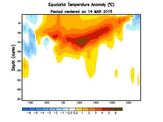
Animation 1
Some may be wondering how pushing water from the western Pacific to the east could strengthen an El Niño when that water in the west is cooler than normal. The answer: even though the anomalies in the western equatorial Pacific are negative, in absolute terms, the water in the western equatorial Pacific is actually warmer than it is in the east. See Animation 2, which is the accompanying animation of the subsurface temperatures of the equatorial Pacific, but shown in absolute terms.
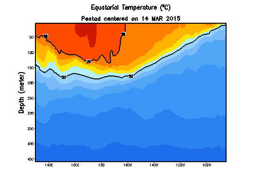
Animation 2
Note the depth of the 20 deg C isotherm as time progresses. It grows deeper in the east as warm water migrates eastward during the evolution of this year’s El Niño. Also note how the warm water is still plentiful at depth in the western equatorial Pacific. And at the surface, it’s still warmer in the west than in the east. So there’s still room for the El Niño to grow.
Normally the 20 deg C isotherm in the eastern equatorial Pacific is close to the surface, so that there is a very distinct slope from west to east, with the warmer water noticeably deeper in the west than in the east. But at the peak of the 1997/98 El Niño, so much warm water had migrated to the east that the 20 deg C isotherm was deeper in the east that it was in the west…the slope reversed.
CLOSING
There are of course different hopes for the El Niño from different parts of the world. Californians are hoping a strong El Niño will bring a temporary end to its drought. And Australians are hoping the El Niño fades because El Niños are associated with drought in Australia.
The recent westerly wind burst could very well help to strengthen the El Niño conditions this year. Then again, Mother Nature always has tricks up her sleeves. Time will tell.
How much did the easterlies in the Indian ocean effect the strength of the 97/98 El Nino? At least for Australia anyway?
I ask as an intrigued Aussie on the East Coast who is yet to see anything remotely resembling El Nino conditions, and is rather thankful for it.
Phil B., I haven’t seen any papers that addressed that subject. Then again, I never looked for any.
That’s fair.
I naturally have a vested interest, since I have no desire to ever live through a Nino event like 97/98 again. The reason for my inquiry is that I’ve noticed a trend where a low will form in the Indian ocean with a trough that extends all the way to the Antarctic, and this moves across the continent bringing cooler weather and rain with it. I imagine that perhaps this wasn’t happening in the 97/98 event and that it might have something to do with the change in Eastern Indian ocean wind direction.
No one sounds dumber than when they are rooting for or against a natural phenomena like ENSO. No doubt the warmists will be gloating soon, but the overwhelming influence of ocean conditions on the climate put into perspective the limited forcing power generated by incremental CO2. I’m here because the atmosphere and the oceans fascinate me. How about you? Thanks for keeping it real, Bob.
I root against an El Nino every year. I lived through 97/98 on the East Coast of Australia and it was just the worst. I struggle, with my genetic aversion to heat, to survive the normal summers in the low to mid 30s. Two weeks straight of 40C is no weather phenomenon to look forward to.
You should move to a little place we call Manitoba. That’ll fix those issues with hot weather.
By Rooting, I mean’t for political or advocacy purposes. This is a real El Nino, but I suspect 97/98 will remaiin the seminal event.
A concise explanation. Thanks Bob.
I second that. Thank you.
Pacific ocean floor is a thin membrane oscillating under influence of the magma pressure points (tectonics !) with its multidecadal oscillations directly reflected in the SOI (southern oscillation index).
http://www.vukcevic.talktalk.net/P-SC.gif
vukcevic,
I’m confused about your sources and what the data that you are measuring/graphing is.
Also, if the Pacific plate tectonics have the 12 year lag, phased with the SOI Index, what is the connection between the 2?
One would think the lagging indicator is a follower, not leader. …………or are you not suggesting an actual cause and just pointing out that they just happen to look similar if you graph them this way?
Mr Maguire hi, hope all is well.
Data:
I intend to write an article (or two) and all data I collected will be tabulated, any data files from other sources will be referenced. I found some time ago that a Chinese paper used my findings, repackaged it without a reference and presented it as original.
12 year delay:
It is matter of semantics (or Slavic against Anglo-Saxon logic). I was about to fly to France few days ago but I delayed it by 7 days to synchronise it with my wife’s flight.
Equatorial tectonics events happened some years ago so I delayed the tectonic graph by 12 years to synchronise it with the SOI graph.
I hope the above resolves the ambiguity
http://www.vukcevic.talktalk.net/SOI.gif
P.S
S.O.I. (Southern Oscillation Index) Archives – 1876 to present
http://www.bom.gov.au/climate/current/soihtm1.shtml
Typhoon Dolphin at CAT 1 was located 2.8 degree north, 161.4 degrees east on May 8th. It looks like the wind burst was driven by the tropical system. Is this a common feature of the wind bursts?
http://weather.unisys.com/hurricane/w_pacific/2015/DOLPHIN/track.gif
http://weather.unisys.com/hurricane/w_pacific/2015/DOLPHIN/track.dat
Yes it definitely was. There was also a low south of the equator at about the same longitude. These together acted to create a nice westerly “wind tunnel” at the equator.
How exciting!
As I have said before, warm SSTs just seem to mean more heat escaping through the Atmosphere and out to space.
It will lead to cooler conditions.
It has to be a very hot & sustained SST to keep the Atmosphere warm for more than a few days.
Bob, I believe that is a 30C isotherm. If you look at the actual temperature on WUWT and the accompanying anomaly chart, you will see the coolier water following the wave.
I was looking at the hot spot of water and I realize that you were looking at the shape of the 20C isotherm boundary. Sorry if I caused confusion.
While the diagrams that are used may be useful I find that this graphical model is far better
http://earth.nullschool.net/#current/wind/surface/level/orthographic=-147.11,7.28,428
It makes a little more visual sense than the metrics and clever diagrams. Perhaps I am unobservant but I see no ‘westerly wind burst’.
I have been checking that site and there was a westerly wind burst driven by a cyclone in the northern ocean and merely a low in the southern ocean just north and south of the equator respectively.
Visual sense, yes. But Earth Wind map comes from an NCEP / US National Weather Service / NOAA model.
So maybe we’ll get an El Nono?
“Australians are hoping El Niño fades as it is associated with drought in Australia”. Maybe, but so far this year, it’s not playing along. Floods have been the issue.
El Nino is supposed to bring cooler and wetter weather to the Oklahoma and Texas areas, so I am very happy to see the rains. Three months ago, 98.52% of the state had some level of drought conditions. AS of last week, it is down to 60.34% and it should look even better with the next report.
http://climate.ok.gov/index.php/climate/map/u.s._drought_monitor_oklahoma/drought_wildfire
However, I wish it would slow down a bit since our lakes in the central and eastern part of the state are filling up fast. The rain can stay out west, where they really need it.
http://www.swt-wc.usace.army.mil/
I’m not sure where they get their information — they must have a poor website because it won’t load — but neither 60.34% of OK or TX are in drought. In fact, more of those states are currently in flood stage than drought.
http://waterwatch.usgs.gov/
Very wet spring in Texas, with lots of rain and lakes are rising/filling. That has been much needed, as lakes were low from drought conditions of a few years ago.
http://www.waterdatafortexas.org/reservoirs/basin
I think it was just the weather – a bit of rain today. I couldn’t get on the Mesonet, which is based in Norman OK at University of Oklahoma for a while. The National Severe Storm Center is also located on the OU campus. I assure you that the website is wonderful since OU, OSU and the State of Oklahoma support it. It is part of the state-wide management system for weather, fire management, ag, education, and many other tasks. In case of emergency, I think the system would get top priority for fixing.
But I was able to access it a while ago which is good since I like to check it myself vs the local stations. And the local stations are wonderful during tornado season. I’m listening to the status of tornados, rain, hail, etc right now…I bet they will approach Norman/Moore OK yet again…
According to the 5/12 report from the USDA/NOAA – 5/12/2015 and 5/5/2015 data
d0-4 60.34 / 70.76
d1-4 47.39 / 59.05
d2-4 24.52 46.19
d3-4 3.72 / 17.95
d4 0 / 4.03
The drought data is for the state of Oklahoma and updated weekly. The new numbers will be out on Thursday, based on today’s data.
It is possible to be both in a drought situation as well as in a flash flood situation. I prefer a slow rain. Rain too fast and the water and topsoil just goes down the drain. But, I’ll let the USDA and the USGS duke it out as to which drought graph is correct.
As far as I am concerned – my sailing club at the local lake (Hefner in OKC) was looking at a dry harbor bed on 4/23 and now, it is at 9’8″ at the east hoist and it is raining with upriver flooding. But, I am still under mandatory water control, until Canton Lake is full – currently at 30%. Canton is further west, so has limited rain and well as drainage area.
The west side of the state is having rain, but the lakes are still in the conservation pool stage, so not even approaching the flood pool stage. On the east side of the state, I think all lakes are in the flood pool stage. Texoma is at 72% ( now at 73% since I started this reply – from 1:00 to 17:00 the water increased 45,150 acre feet of water – that’s a bunch of water or 14,712,191,929 gallons) of the flood pool and releasing. Lake Eufaula is 114% flood pool and can’t keep up with releasing the water. You can cruise around the USACE site for specific data –
http://www.swt-wc.usace.army.mil/default.html
I look forward to the new report on Thursday, but I am glad that the local govt is finally realizing that they need to keep up in mandatory water rationing (it is just odd/even watering) as a permanent situation.
Oklahoma, where the winds come sweeping down the plains….
Go El Nino!
Thanks, Bob.
With an El Niño forecast till the end of 2015, it is natural to see westerly wind bursts and Kelvin waves show up. Thanks for the view!
Kelvin wave is similar to last year.
Let us see circulation in the Pacific. It starts to dominate East.
http://www.sat24.com/world.aspx?region=am
I’ve always wondered about the nomenclature of wind direction. If I asked “Which direction are you walking?” and you responded “Westerly” I would assume you were moving from east to west. But when the weatherman mentions “westerly” winds, the opposite is intended.
So how did weather phenomena get their names (westerly, nor’easter, etc.)?
Direction the winds come from. Very important in navigation by sail, among other things.
Regardless of which way you are facing, the wind is always blowing towards you.
There, the science is settled.
It appears that instantaneous changes [increases over the last 2 weeks] in the Flux cause Equatorial Winds to increase. Now that the Flux is collapsing, expect the Equatorial Winds to decrease!
Everyone looks at the El Niño for California Rain. We are now in a decreasing Solar Cycle. Less California Rain and more drought. Expect the opposite of an increasing Solar Cycle.
Everyone has opinions. New ideas are trashed by the blogs. Do you feel better by attacking or by attempting to find the cause of what is happening??
See more current water temperature in the Pacific on the equator. You can see how deep in the Pacific is 20 degrees C isotherm. Eastern Pacific is clearly cooler.
http://www.cpc.noaa.gov/products/analysis_monitoring/ocean/weeklyenso_clim_81-10/wkd20eq2.gif
That’s how dumb I am.
I regard El Ninos as weather – not climate.
I am also so dumb that I regard anything that has happened in the last 200 years was weather – not climate.
here in the western pacific we had dry weather for a while and then the rains descended upon us. From my coral reef I don’t see cold water temps.
Too bad I was looking for some good fishing