A couple of days ago I posted this story about the odd hole in the ground that appeared in Yamal, which was immediately blamed on ‘global warming’ by some fool who hadn’t looked at it closely:
Anna Kurchatova from the Sub-Arctic Scientific Research Centre, thinks the crater was formed by a mixture of water, salt and gas igniting an underground explosion, a result of global warming.
The most plausible explanation so far is a collapsed “pingo”, and these new pictures and video from the Siberian Times suggest it probably is. The pictures below from Parks Canada show similar structures in the process of collapse. For those that want to blame the collapse on “global warming” you might also note it is summer in Yamal, and melting ice is a regular and expected occurrence.
Here is what a pingo structure looks like in cross section:

Here is what Parks Canada has to say about them:
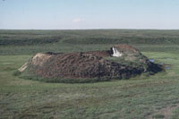
Collapsing pingo
© Parks Canada / 1988
When a pingo is growing, the ground stretches to accommodate its increasing surface area. The tundra splits apart in places, forming cracks – usually along the length of the pingo, especially near its summit – that may reach down as far as the ice core. If these cracks are large enough, the top of a pingo will resemble a crater. Sometimes water ponds in the crater, and this may begin to melt the ice core. More commonly, uplift of the sides of the pingo creates steep slopes that may become unstable and begin to erode. If the ice is exposed to the sun, the core will begin to melt. As its main support melts away, the pingo collapses.

Collapsed pingo
© Parks Canada
When the ice core has completely melted, all that remains is a doughnut-shaped ring of raised tundra enclosing a small round lake. In warmer regions, such as Ireland and the Netherlands, remnants of collapsed pingos have helped scientists determine that the climate was once cold enough in these areas to support a permafrost environment.
Source: http://www.pc.gc.ca/eng/docs/v-g/pingo/sec3/natcul1.aspx
And here is new video and pictures from the Siberian Times:


The hole is in the Yamalo-Nenets Autonomous, some 30 kilometres from the Bovanenkovo gas field. Pictures: Marya Zulinova, press service of the Governor YaNAO
More here: http://siberiantimes.com/science/casestudy/news/first-pictures-from-inside-the-crater-at-the-end-of-the-world/
UPDATE: A look at Google Earth for Yamalo-Nenets Autonomous reveals something like Minnesota’s Land-O-Lakes, but looks a lot like Land-O-Holes. See sat image:

Pulled up the Yamal Peninsula on google earth the other day after the first reports came out and saw they had those holes and ponds all over the place. Just a natural re-occurring phenomenon.
There are several similar features nearby. Wonder how deep they might be.
Look at the vegitation right up to the edge and the heavily eroded walls of the crater.
As I said yesterday, this feature is not new. Even without knowing the geology , I would guess that kind of erosion is centuries old.
I suspect that there is some relationship between these and ice lenses that form under paved roads and cause the surface of the road to lift across the width of the pavement (this is North American usage of “pavement” to refer to the roadway used by motor vehicles; it may have a different meaning in the UK, Australia, etc.). Our country road in eastern Canada has dozens of these, and driving on them in late winter is rough!
Ian M
Definitely aliens.
I think there is an error on the origin of the second from last photo ( cribbed from siberiantimes.com ).
It seems to be very different geology, rock rather than permafrost, and physically too different to be a photo of the same location. That kind of erosion would take centuries.
Still the vegetation around the rim shows that this feature has been building for a long time.
this is a recent _discovery_ not a recent event.
Could this be the crash site of MH370 !? They never did find it and it would be cool to blame the Russians for this one too.
It looks very similar in shape to the hole in the ground in Pennsylvania.
When one has no knowledge of the past, or willfully ignores said past;
Then it is always Unprecedented.
Perhaps it is way past time we focussed on the insanity of these credulous twits and just laugh at them.
Where are the modern satirists?
Hashtag; I am a moron?
Aliens!?!
Ian L. McQueen says:
July 18, 2014 at 7:40 am
I suspect that there is some relationship between these and ice lenses that form under paved roads and cause the surface of the road to lift
Yes , there may be some mileage in that idea.
A bit like a glass bottle bursting as it freezes outside: the top forms a bung and then expansion as the lower water expands as it approaches freezing forces outwards. That is presumably the pingo mechanism that produces the characteristic raised ring.
This implies that the surrounding ground is not solid rock ( although there appears to be a lot of rock in it ). Permafrost would yield under the pressure.
plagarizing a bit:
‘Inside every global warming scare is a natural occurance struggling to be grasped.”
MaxedOutMama said:
July 15, 2014 at 7:51 pm
It’s a pingo sinkhole…
—————-
We have a winner!
A much better explanation.
Neither salt nor water are ignitable. CH4 ignites between 5%(LEL) and 15% (UEL) in AIR with a source of ignition. You cannot ignite a methane between 5% and 15% volume in air by compression, e.g., the cylinder of a diesel engine unless you have a secondary ignition source such as a “pilot charge” of oil. Below and above the flammable limits it won’t ignite. Her explanation had a few holes in it.
Ian L. McQueen says:
July 18, 2014 at 7:40 am
The language is an engineering one, so its meaning is pretty similar here in the UK. Sometimes we just say bitmac or macadam or roadway & at times pavement!
Anyway, isn’t NATURE just blooming marvellous, such fantastic sculpturing of the rock. Looks to me as though it’s been there for a while, certainly beneath the surface if not at the surface! It also looked like the water at the bottom of the hole was fairly shallow as it looked like one could see the rock beneath it, then again may just be me, after all it’s approaching 5pm on a hot sticky Friday afternoon, beer time beckons! HAGWE folks!
Gigantic moles!
I’d never heard of a pingo before, but it sounds like a plausible explanation. And a helluva lot more likely than ‘global warming’, which is a somewhat implausible theory since there hasn’t been any for nearly 18 years.
Hang on, though, maybe Yamal-based pingos have a special 20-year delay feature before they collapse – and so perhaps, this one was merely responding to a slight increase in global temperature from way back in the mid-’90’s.
I mean, they’ve got some fairly special trees over that way too, I hear. Or was it just one?
/sarc.
What I noticed from the latest video posted over at the original article was the clothes the people were wearing. Mid July, northern Hemisphere, and they are dressed like it is November!
Siberia is a cold place!
Nah, it’s a Russian mafia boss’s Sarlac pit.
I agree, that 2nd from last picture is NOT the same crater.
REPLY: I’m sorry, but you are wrong on this claim. You can match up the water etched paths on the rim and walls with the other photos. Just different lighting conditions, like the sun coming out from behind a cloud – Anthony
The reaction to this incident demonstrates that for many Global Warming is not a theory nor an hypothesis, but a superstition. Global Warming is is not the new normal, it’s the new Devil.
Next thing you know this thing will be responsible for slowing down the Gulf Stream.
In southern New England where the freeze-thaw cycle repeats often in the winter, we call these thing potholes.
Let’s learn from this, and figure out how to use injection wells to dig big caverns for us.
Are you sure that isn’t really a diagram of a sebaceous gland?
@ Resourceguy –
You know… that theory doesn’t sound entirely implausible. I bet you could get a research grant to study that…
I’m trying to find a reference site that shows temperature data for the Yamal Peninsula going back a few decades. Does anyone know where I can find one? Google searches turn up lots of articles from places like The Guardian and other useless alarmism, I’d like to see the raw(ish) data.
don’t know what this is about. you figure. I probably don’t care
Yamal was also the home of that freak tree whose rings became the basis for the infamous hockey stick. I wonder if anyone has investigated the possibility that Yamal tree rings respond to nearby pingos. It might help explain the freak tree.
“The researchers were unable to make their way to the bottom of the lake, but did go inside the crater.
‘There is ice inside the crater which gradually thaws under the sun.
‘Also there is melted water flowing down from its sides, you can see water traces on the pictures. The crater is filled with ice by about eighty per cent. ‘
He stressed: ‘We are working with space photographs to figure out exact time of its formation.
‘We have taken soil and ice samples which went straight to laboratories. We can be certain in saying that the crater appeared relatively recently, perhaps a year or two ago; so it is a recent formation, we are not talking about dozen years ago.
‘Could it be linked to the global warming? We have to continue our research to answer this question.
‘Two previous summers – years 2012 and 2013 were relatively hot for Yamal, perhaps this has somehow influenced the formation of the crater.
‘But we have to do our tests and research first and then say it more definitively’.
My expertise on pingos consists of reading what Anthony posted and what is on Wikipedia (I had never heard of them before 20 minutes ago), so maybe my opinion is the result of ignorance, but I don’t think it’s a pingo. The news article describes the hole as being about 30 meters wide and 70 meters deep, and the pictures show a relatively small rim of material on the surface. Based on the brief descriptions and photos of known pingos, I would have expected a more shallow depth to width ratio with more material on the rim. Maybe somebody can find some more information to disprove me.
Also, it appears to me that there is a shallow stream bed leading to the hole, but none leading away from the hole, as though it was acting like a drain.
A “pingo.” That’s actually pretty cool. 🙂
According to the top diagram, this is a spring that freezes solid and deep. One of the pictures shows a creek bed leaving the hole as it’s origin.
Frost heave on a large scale.
I got to thinking that the forces might be similar to a mud volcano.
Aha!
This is a vertical glacier!
An ice plug forms in the winter, but hydrologic forces cause the plug to rises slowly, scraping and smoothing the walls, as water fills in below to freeze again.
The only fly in the ointment is that currently the water table is very low. At present, the thing is NOT a SPRING. Something changed to lower the water table, perhaps another pingo down slope.
Mosh:
Could it be linked to the global warming? We have to continue our research to answer this question. Two previous summers – years 2012 and 2013 were relatively hot for Yamal, perhaps this has somehow influenced the formation of the crater. Perhaps it reached its tipping point a fraction of a second earlier than it might have done without our carbon-forcing. Although the landscape implies that this kind of event is frequent and mundane, we think this time it might be special. But we have to do our tests and research first and then say it more definitively. Until then, keep worrying.
No the planets got zits!
James Bull
So.. how do we know it is not a meteorite crater?
To me it looks like a huge sink-hole.
Spatial distribution of pingos in northern Asia
http://www.the-cryosphere.net/5/13/2011/tc-5-13-2011.pdf (8 MB)
Fig. 5.Spatial point density of pingo locations using a 20×20 km search window (400 km2) and 5 km grid cell size. Histogram shows pingo distribution by geographical latitude. Black outline in this and subsequent figures indicates the study area boundary
The map covers from 60 E to 170 W across all of Siberia. Pingos are mapped from 61 N to 74 N.
Over 1620 pingos mapped.
Table 4: Pingo Density. Yamal is less than 13 / 100 km^2
The Wikipedia article on “Thermokarst” is a good source for references to other arctic, periglacial, and permafrost landform types and vocabulary.
Pingos are true perennial permafrost mounds. It is generally accepted that there are two main types of pingos in terms of genesis: hydrostatic (closed system) and hydraulic (open system). It is here proposed that a third category of ‘polygenetic’ (or ‘mixed’) pingos should also be recognized in the light of published work and recent investigations. The lack of comprehension of hydraulic pingo genesis would seem to add weight to this proposal. Since suitable conditions for the formation of pure hydrostatic pingos are rarely met outside the Mackenzie Delta/Tuktoyaktuk Peninsula area the ‘world’ type of pingo is most likely to be of an hydraulic or ‘polygenetic’ variety and thus further investigation is warranted, particularly for the elucidation of the palaeoenvironmental inferences of ‘relict pingos’.
http://www.aina.ucalgary.ca/scripts/minisa.dll/157/1/0?SEARCH
I have been anxiously awaiting Keith Briffa’s new book: “A Tree Grows in Yamal”.
Perhaps he is already working on the sequel: “A Pingo Grows in Yamal”
(sarc off)
Temperature data for Yamal can be found at http://met.no/filestore/Ealat_Yamal_climaterep_dvs-1.pdf
Kwar
“Until then, keep worrying.”
huh. I’m not worried about global warming. not one bit.
I just note people’s lack of skepticism and their rush to judgment about everything remotely related to their cherished beliefs.
good skeptics say.. we need to look more closely, pingo bingo
Related…..ice wedge polygons.
Did Kevin check it for his missing heat?
Looks pretty warm inside that hole.
cn
Reminds me of working on top of an old landfill. The gases from all the decaying garbage would build up beneath the surface and during wet weather, there’d be these little mounds of upheaved turf that would develop, some to about a meter in height. They could be popped with a pick or just let be.
GaryB says:
July 18, 2014 at 9:21 am
In southern New England where the freeze-thaw cycle repeats often in the winter, we call these thing potholes.
======================================
Frost heaves. Bang!!! Damn!! Trick is to watch for chunks of ice along the side of the road from where the ice has broken off of the wheel wells of the previous victims of the FH.
looks just like the earthworm holes I see in the driveway after a rain storm (bigger of course) I say a giant prehistoric earth worm popped up for a look didn’t like what he seen and went back to sleep ;0)
It appears to be an artesian spring that froze then thawed. So they’re not just for making beer anymore. http://en.wikipedia.org/wiki/Olympia_Brewing_Company#Use_of_Artesian_water
Someone should do a macro of Christophe Waltz in Inglorious Basterds saying “That’s a Pingo!”
That looks like a sink-hole. Around here, water underground + limestone = sink-hole as the water contains acids naturally strong enough to dissolve the calcium carbonate (or in the case of dolomite sink-holes, magnesium carbonate). Ah so a major ‘frost-heave’ followed by a collapse when the water flows away does the same thing.
This hole was caused by YAD 061, the ‘warm’ tree that caused Al Gore’s hockey stick. This tree eventually got so hot, it burned a hole through the permafrost.
/sarc
If it appeared in just the last couple years how could it be linked to global warming? There has been no “global” warming for many years now as the UK Met Office, NASA, and UAH satellite all show:
http://www.cru.uea.ac.uk/cru/data/temperature/HadCRUT4.png
http://data.giss.nasa.gov/gistemp/graphs_v3/Fig.A.gif
http://nsstc.uah.edu/climate/2014/june2014/June2014graf.png
Local and regional warming, however, happens all the time. If it’s a pingo / hydrolaccolith / bulganniakh, then of course local or regional warming explains it. Alarmists conveniently mix up “global” and “local” warming (or sea level rise) to suit their whim just like they do with “climate” and “weather”. If you’re an alarmist, apparently you CAN have it both ways.
space aliens – obviously
Apparently, Australian climate researchers were seen uprooting a tree in the area not so long ago…
Ok…so was there ejecta or not? Is the stuff around the rim earth that had been raised by something underneath…and then when that something disappeared (like water dropping further downstream) it collapsed into the hole leaving a raised edge? Or did something eject out of it? It doesn’t look like there’s enough topside to have filled the entire hole. And if this JUST happened, there would be dirt on top of the ice at the bottom…there’s not. It’s shiney clear on the surface. So if it’s a sink hole…where did the crap that “sank” go?
Godzilla is on the rampage i am guess Mothra is coming to save the day, rejoice.
So it is a sink hole, but a special kind of sink hole called from a collapsing pingo. I learn something every day. Still…where is the hydrostatic water that seems to be required to build a pingo? We have a picture of the water at the bottom, but that is 200 feet down and it looks like there are dark recesses that may go deeper around the edges. Are Yamal lakes typically 200 feet deep? If not, is this something else?
I admit that I was wrong about the broken earth around the top being lower than the surrounding plane. There are definitely piles that are higher than the immediate country side, but if it is a pingo, there was no ‘ejection’. It is simply what is left of a collapsing mound. And there was certainly never any burning of the soil. The initial images did not support that idea at all.
I still think there is more to this pingo than meets the eye. I hope someone goes down in there and takes a look around.
I also wish we had the exact coordinates and could look at the area on Google Earth. ‘About 30 kilometers from that gas field’ is just not much of a clue! At least the articles could report which direction it is from the gas field!
It’s the ‘Horta’ from the original Star Trek series for cryin’ out loud.
Some Trekies you guys turned out to be.
You guys are not nerds.
Reblogged this on leclinton and commented:
Thank’s Antho-ney seen these in the territory’s Canada but never had a name for them till now ;>)
MASTER OF UNIVERSE says:
July 18, 2014 at 5:52 pm
These are not the droids your looking for move along now ;>)
All that is needed is a REALLY large tube of Clearasil….problem solved…(actually, truth stranger than fiction…just read that in Poland eight people got pulled into a quicksand hole…seven of them jumped in trying to rescue the first (if I read it correctly))…..whenever we think we know it all, nature comes up with something new….be careful out there, folks….
Greg says:
July 18, 2014 at 8:02 am
In Canada and around the north we call it Tundra mostly dead moss “liken” and some rocks left there glacier drop of from the melt back , and 1 meter of permma frost . I have seen these all over the north when there is a higher water source ;>)
classicalhero7 says:
July 18, 2014 at 2:03 pm
Someone should do a macro of Christophe Waltz in Inglorious Basterds saying “That’s a Pingo!”
Don’t know why you made me laugh so hard but the picture in my mind was jolting.
Hi Love this post ,
I like this website very much so much excellent info.
thank you for posting .
This new footage provides some essential new information. We are clearly located on the Siberain tundra, with marshes, thermocarsts, and plenty of sub-surface methane. Judging from the debris around this crater, it has erupted several times before. Thus, it probably has an unknown history of annual or bi-annual eruption, just like a mud volcano. However, the pipe leading down to the water is pretty deep (perhaps 30m?). This means that the erupting methane, probably has had an overburden of material that is 30 m thick. It means that the reservoir of gas has to build up a pressure greater than the overburden pressure before it erupts. The eruption of this pingo-like structure is, however not very dramatic, as it does not necessarily ignite (like most mud volcanic eruptions do – se the Lokbatan eruption in Baku, some years ago).
My conclusion is that this is a local pressure release crater, much like submarine pockmarks, in the world’s oceans and lakes. They are very rare on land (in Norway, there is only one known occurrence of a marsh hole caused by methane blowout, but much smaller than this one).
It probably is a collapsed crater of any extinct volcano or …… just a sink hole.
So hemispheric warming rather than global. I’m surprised that isn’t blamed on “carbon pollution”.
Pingos used to cause havoc.
Notice the shrubby vegetation around the sides of the crater but not farther away–the raised area provides drainage that allows plants to grow better than in the nearby water-logged soils.
But are there pingos on Mars?
http://apod.nasa.gov/apod/ap140309.html
http://news.nationalgeographic.com/news/2010/12/photogalleries/101221-mars-pits-pictures-photos-science-nasa-space-caves/
“Anna Kurchatova from the Sub-Arctic Scientific Research Centre…” ‘Sub-Arctic’ and she doesn’t know what a pingo is!!! What doesn’t the researcher know about the tundra? I think a few years in a Siberian gulag would help her understand.
MASTER OF UNIVERSE says:
July 18, 2014 at 5:52 pm
It’s the ‘Horta’ from the original Star Trek series for cryin’ out loud.
Looks more like a Sarlacc pit to me.
@jim Clarke at 7/18 5:24 pm
There are definitely piles that are higher than the immediate country side, but if it is a pingo, there was no ‘ejection’. It is simply what is left of a collapsing mound. And there was certainly never any burning of the soil. The initial images did not support that idea at all.
Change your timescale. This was a vertical glacier that moved upwards at a slow pace. It is an artesian spring that freezes down through permafrost. Hydrostatic forces push the plug slowly upward, “ejecting” ice and rock upwards at rates of mm/day. It may have grown for hundreds or thousands of years. Look at the surface photos. There is one creek that radiates away from the hole. That drains away the water from the extruded ice as it melts in the summer.
What happened in the past couple years is the artesian spring has stopped. The ground water table has dropped by maybe 200 ft. That stops the growth of the ice core. It allows the core to melt, collapse, lose it’s soil cap insulation, and melt faster in the summer.
Why has the ground water forces changed? Could it be a change in a pingo down slope? Has it anything to do with the development of a supergiant gas field on the horizon? For instance, are they using water injection for pressure maintenance in the field and if so, where are they getting the water year round? Did they have an artesian blowout in drilling before surface casing? The time, place, and the magnitude of the change makes me suspect the gas field development has something to do with the evolution of the hole left by a melted pingo.
Notice how there isn’t a single Nauga (the source of Naugahyde) any more.
It’s this hole …
“When the ice core has completely melted, all that remains is a doughnut-shaped ring of raised tundra enclosing a small round lake.” Where’s the lake, where’s the ground water to cause the pingo?
My experience with Pingo type structures, is that they are extremely dangerous during their initial stages. During the summer melt they are like an icy, partly water filled cavern, right below the surface of the tundra. Walking alone in the tundra and falling through the vegetation covering the cavern, is generally fatal. These structures have other names in other places and are the source of some sad tales. Pingo may not be the correct name for the small ones in English.
Learn something new everyday! What a neat bit of information – and a process I’d never heard of before. Thanks Anthony! All the info, new pictures, video, and links to even more photos are great.
I don’t think this crater would be a big surprise to anyone who has seen quick sand that reaches quicking pore pressure and watched the water and air make tiny little craters like this one; or has worked in permafrost areas; or watched rocks get jacked out of the ground by ice lenses; or had to repound fence posts that are continually frost jacked out of the ground; or uncovered a moss covered mound to find a couple of metres of ice fed by ground water … oh, but then most folks don’t live in places that are frozen for 6 months of the year.
The scour in the hole is pretty amazing but the pressures that work in those conditions are also pretty amazing. I suspect there are some geotechnical people on this site that could give some numbers but soil, water and ice pressure variations go from 0 to huge and from huge to 0 very quickly in the right circumstances.
Great photographs. I hope there is some follow up on the stratigraphy of the hole.
Watching the British Open, I couldn’t help noticing the Royal Liverpool course is littered with these things.
I think that’s one of earths assholes…
The CSMonitor is recycling another batch of pingos as extraterrestrial in origin, or maybe global warming, but they’re keeping it kind of nebulous. “It’s an unexplainable mystery”, they say.