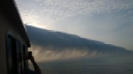
 I thought readers might enjoy this photo. This frontal cloud formed from a northeast wind shift and lifting of humid ocean air enough to cool it below the dew point. The cold air acts a bit like the leading edge of an airplane wing. Taken about 5 miles offshore of Seaside Heights New Jersey, 8am May 14th, 2014
This photo was taken by commercial fishermen Michael Wark on his boat.
Click the image for a full sized view. Another example is seen below:

Frontal clouds, Uruguay
I saw one of these off Myrtle Beach a few years ago. It was spooky, outside my realm of experience.
That is a beautiful photo. I have seen this a couple of times in my life. Usually just before getting really wet in the rain that follows.
They are called ‘morning glories’
You might enjoy these pictures as well. Same feature, Salento, southeastern Italy two days ago.
http://www.meteoweb.eu/2014/06/forte-maltempo-ieri-sul-salento-straordinaria-e-rara-roll-cloud-al-largo-di-otranto-foto/289699/
Isn’t this similar to the roll cloud found in Northern Australia. Lots of pretty pics on Goole images
Trippy….
http://youtu.be/FHixChYgGRI
Is this the same as a ‘seafret’? We used to get them when I lived in Dorset and now the same thing happens in Corfu. We see the bank of cloud rolling up from the sea over the top of Pelekas and that has to climb over 250m before we see it from our house.
Fantastic, great shot. Saw the same thing in Hervey Bay, Qld in 2005. Just amazing to look up as it rolls over. Great!!!
Are you sure those are clouds, Anthony? They look like the big flexy ductwork installed by the Obama administration to blow CO2 directly to outer space, saving our grandchildren from a life of mediocrely warm temperatures. (sarc off)
PS: It is a beautiful picture.
@NikFromNYC
Far out, man!
“Taken about 5 miles offshore of Seaside Heights New Jersey, 8am May 14th, 2014”, err did I misread that?
[ not sure what you are getting at? -mod]
At sea in a small boat these usually put the fear of God into me. We had one pass overhead off the Baja coast. Ended up doing 12 knots under bare poles in a 26′ boat. Theoretically impossible, but all the same it was one wild ride.
Nature is beautiful. Too bad the CAGW alarmists don’t think so – unusual (but perfectly natural) weather phenomena such as this are branded as “unprecedented” and due to “man-made” climate change.
Looks very similar to a “rotor” cloud common on the lee side of mountain ranges. Getting anywhere near one in a Cessna will make you a believer. very quickly.
Mark,
I did the same thing at first. The top, tiny, photo was taken near New Jersey, the larger photo is a different cloud, of the same type, taken in Uruguay.
Very nice. Is it the colder air of a sea breeze running into milder air coming off the land?
Oh, who cares…
Sometimes I look at skies to simply escape all the nonsense going on down here on earth. They helped me endure many a Math class.
Unfortunately clouds can be a sort of a Rorschach test for what is in the back of your mind, and among all the sheep in the sky you can abruptly see…Oh horrors! Michael Mann!
Alarmists can attempt to pollute even the heavens with their pessimistic, depressing dogma, however I still can find comfort in clouds, for I know that, fleeting as they may be, they’ll still be doing their thing long after all our troubles are forgotten.
The clouds in Australia are know as “Morning Glories”. It is up on the Gulf of Carpentaria. They can be almost a thousand miles long.
http://content.cleancruising.com.au/images/ports/AUGOC.jpg
Full frontal cloudity.
Alas, our children are just not going to know what clouds are.
Didn’t any of you see Independence Day? There is an alien ship hiding behind that cloud. The invasion has started…..in New Jersey.
Have seen these clouds out in the foothills of Alberta – fast moving, almost scary:
See if that works.
If not:
http://i57.tinypic.com/35d3jms.jpg
http://i58.tinypic.com/2qkjtdh.jpg
Great photo and nice to see I’m not the only fan of “The Orb” on the board.
Looks like a fluffy tsunami.
Beautiful! But you are all wrong. It’s a chem-trail. :«)
It’s Bush’s fault.
its completely consistent to what we’d expect from a warming climate; in fact, everything is completely consistent with that fact.
It is a Soliton Roll-cloud, very familiar off the Queensland coast. But I think this is a sea-breaze phenomina, rather than being associated with a cold front.
R
I was fortunate enough to be piloting a glider in the early evening to catch a sea-breeze front in
East Anglia, enabling what I had expected to be a routine 15 min last flight of the day to turn into a gentle 45 min flight in and out of the leading edge of the front, ending only because nightfall required landing, not weather. The photos here are much more spectacular, longer and more well-defined than what I saw in that flight but has a similar character. I just want to be in that leading edge with no engine! Only the completely different phenomenon of high altitude lee-wave soaring competes for the strange calmness and transient beauty of these meteorological phenomena.
The sea breeze is a mesoscale cold front.
Through sheer utter luck and nothing else back in about 1973 I just happened to get an aerotow launch in my glider just as a roll cloud started to form some 5 kms away from our airfield .
During the tow I happened to glance away to one side and there about 5 kms away out of a clear no cloud sky , a small cloud about the size of a house just formed in seconds but only a hundred or so feet above the ground. To say I was at first absolutely flabbergasted and secondly absolutely busting to get to that cloud and fast in my glider would be an understatement.
The tuggie up front also saw it and of course made for it as fast as we could.
Even long before I reached that cloud about 5 minutes after we first saw it, that house size cloud started expanding into a roll cloud at a phenomenal speed extending NW / SE in a long roll nearly identical in both configuration, size and height above the ground as that Uruguay roll cloud photo above, at kilometres per minute both ways from that first small house sized cloud.
So I got the unbelievable opportunity to ride along the front of near an identical roll cloud to the one in the photo in my glider but this time some 200 kms inland near Horsham in western Victoria in SE Australia.
The unbelievable, incredible thrill and excitement of sitting at about 200 to 300 feet above ground and running at 100 knots plus [180 KPH plus ] for tens of kilometres along the front of the roll cloud in a glider with my wing tip running through the cloud mass as it rolled across the wide open very flat terrain was something I haven’t ever forgotten.
That roll cloud as it developed literally within a few minutes from one very small house sized cloud just above the ground to a roll cloud identical to that in the above photo that extended as far as I could see in the clear air and at least 50 kilometres each side of where I was flying was a truly astonishing weather event to witness and experience.
I could pull up into a vertical climb for a 1000 feet in my glider and well above the roll cloud in the lift area in front of the cloud and then roll over and dive away down again down to the front of the now steadily advancing further inland roll cloud and resume the running along the front of the roll cloud all over again.
The roll cloud slowly thickened up as it moved further inland and the frontal system formed and developed over an hour or so and when the frontal cloud mass reached about two thousand feet in height with a far as the eye could see mass of cloud developing behind it, it started to break up. I headed into a gap in the by then vertical cloud front which reached right down to ground level in an attempt to penetrate back to my home field which the roll cloud had swept over an hour or so beforehand.
I got shot down by very heavy rain immediately behind by the then developing frontal system which by then no longer had any evidence of a roll cloud but was the leading line cloud mass of a developing fronntal cloud mass. SoI had to walk the 6 or 7 kilometres back to my home field and to my concerned fellow club members in pouring rain.
That was just one hell of a flight that so very, very few in aviation have ever experienced.
And unlike the well known Morning Glory of the Gulf of Carpentaria where it rolls in at some thousands of feet above ground level, this was all done at altitudes of only some 200 to 800 feet above the ground and right at my home gliding field.
One of my fellow pilots and a student also got a few minutes riding the roll cloud before landing just before it swept over our airfield.
Another pilot saw two identical roll clouds just on daybreak a few weeks later in our same region but I have never seen or heard of any similar roll clouds being seen in our patch since.
come to Minden, catch the wave spring, winter or fall and sometimes even in summer.
At 76 years old and on a pension nowadays it’s bit late in life to go to Minden for me, Mike.
Besides I punched out my diamond height locally on the small by your standards, Grampians Mountain range here in west Vic with a climb of 23,600 feet, a 20,600 gain of height back in 1968 and all on an oxygen system pinched from the local hospital which I had to keep adjusing the O2 flow rates as I climbed in the wave.
All three diamonds,were done in an entirely wood Australian built Boomerang glider.
Fourth three diamond badge in Australia. Second with all three diamonds earn’t in Australia.
FAI badge number 994.
Looks like Weather Weirding to me. A picture of it is worth a thousand data points.