Comparisons are still being made of the 1997/98 El Niño with the El Niño forming this year. So I thought we should compare the weekly sea surface temperature anomalies for this year, in two NINO regions, with those during 1997 for the 1997/98 El Niño and 1982 for the 1982/83 El Niño. The 1982/83 and 1997/98 El Niño events were the two strongest single-season events of the late 20th Century. (The 1986/87/88 El Niño wasn’t as strong as the 1982/83 El Niño in terms of peak sea surface temperature anomalies, but the 1986/87/88 event remained an El Niño for more than one year, so it was likely comparable to the 1982/83 El Niño if duration is taken into account.)
First, the NINO3.4 region, see Figure 1. The NINO3.4 region is bordered by the coordinates of 5S-5N, 170W-120W. See the illustration here for the location. It captures the sea surface temperature anomalies of the east-central equatorial Pacific. Sea surface temperature anomalies of the NINO3.4 region are a commonly used index for the strength, timing and duration of El Niño and La Niña events. And as you can see, the weekly NINO3.4 sea surface temperature anomalies still have not reached the +0.5 deg C threshold of El Niño conditions. It’s still a little early. They are presently at +0.31 Deg C compared to the reference years of 1971-2000.

Figure 1
Sea surface temperature anomalies in the NINO3.4 region are evolving about the same as they did for the 1982/83 and 1997/98 El Niños.
– HOWEVER –
Sea surface temperature anomalies of the NINO3.4 region really don’t do justice to the 1997/98 El Niño. That El Niño was freakish in how quickly it evolved in the eastern (not central) equatorial Pacific and how warm the sea surface temperatures eventually grew there. We can use the sea surface temperature anomalies of the NINO1+2 region to illustrate this. See Figure 2. The NINO1+2 region is bordered by the coordinates of 10S-0, 90W-80W. It’s just west and south of the Galapagos Islands.
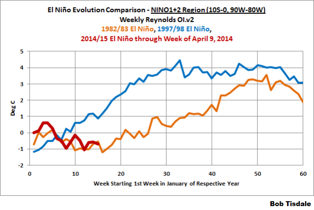
Figure 2
The sea surface temperature anomalies in the eastern equatorial Pacific are evolving this year more like the 1982/83 El Niño. The NINO1+2 data for 1997 shows east Pacific sea surface temperatures warmed much sooner during the 1997/98 El Niño.
The 1982/83 El Niño was strong, there’s no doubt about that, but it was nowhere close to being comparable to the 1997/98 El Niño as an east Pacific event.
A couple of things to keep in mind: First, there are subtle differences between El Niño events. It’s still very early in the evolution this year to make predictions of how strong the 2014/15 El Niño will eventually become.
Second, before you look at global surface temperature data and conclude that the 1982/83 El Niño had a very small effect on global surface temperatures, compared to the 1997/98 El Niño, keep in mind that the 1982/83 El Niño was counteracted by the eruption of El Chichon that year and there was no colossal explosive volcano in 1997 to offset the 1997/98 El Nino.
EARLIER POSTS IN THIS SERIES
- The 2014/15 El Niño – Part 1 – The Initial Processes of the El Niño.
- The 2014/15 El Niño – Part 2 – The Alarmist Misinformation (BS) Begins
FURTHER READING
My ebook Who Turned on the Heat? goes into much more detail to explain El Niño and La Niña processes and the long-term aftereffects of strong El Niño events. I’ve lowered the price of Who Turned on the Heat? from U.S.$8.00 to U.S.$5.00…with hope of increasing sales a little bit. A free preview in pdf format is here. The preview includes the Table of Contents, the Introduction, the first half of section 1 (which was provided complete in the post here), a discussion of the cover, and the Closing. Take a run through the Table of Contents. It is a very-detailed and well-illustrated book—using data from the real world, not models of a virtual world. Who Turned on the Heat? is only available in pdf format…and will only be available in that format. Click here to purchase a copy. Thanks.
Oops, I forgot to include the data source:
The Sea Surface Temperature anomaly data used in this post is available through the NOAA NOMADS website:
http://nomad1.ncep.noaa.gov/cgi-bin/pdisp_sst.sh
or:
http://nomad3.ncep.noaa.gov/cgi-bin/pdisp_sst.sh?lite=
Perhaps you can also include a graph on number of “the sky is falling” articles on the three El Nino events.
Seriously, thanks for just posting the facts and letting us figure it out. You and the other authors here are the best.
Hey Bob, there has been excitement over the past couple of years about an El Nino forming, is this years trend so far any stronger evidence than previous?
Bob, you write ” with the El Niño forming this year.”
So you are predicting that, without any doubt at all, there will be an El Nino this year. I know virtually nothing about the subject, but I still have doubts that an El Nino will, in fact, form in 2014.
Since the Eastern Pacific sits on the “ring of fire” has anyone ever made a study of subsurface volcanoes and El Nino formation. IMHO the only thing that would cause an “early” temperature development would be SSV activity.
13April: The Economist Blog: Babbage: Rebels without a cause?
A study published online today for Nature Climate Change, led by Philip Munday from James Cook University in Australia, suggests that elevated levels of carbon dioxide in seawater affect the behaviour of young damselfish and cardinalfish in a manner that may ultimately, in natural ecosystems, harm larger marine communities. Juveniles living in more acidic environments appeared oblivious to the dangers therein, acting more rashly than fish from less acidic areas as a result…
Dr Munday and his team therefore studied three sites off Papua New Guinea to test the effects of continuous carbon dioxide exposure on reef fish behaviour…
First a tank was prepared containing a two-channel choice flume filled with water streams either conditioned with or without odour from predatory fish. Then the team captured ten individuals from each of the species under consideration and monitored which stream they would prefer to swim in over four minutes…
Results across the species were similar. But they differed when fish from more acidic waters were compared with those from control communities. Fish used to higher levels of carbon dioxide spent 90% of their time in water perfumed with predators; control fish spent all their time in the other stream…
The rash behaviour of fish accustomed to higher acidity did not stop there, however. After being placed individually within another tank that contained a small coral colony for shelter, the scaly participants were left for two hours (so they could get used to their new surroundings). Their activity, and the distance they travelled from the coral, were then observed for five minutes after which the fish were “chased” back home with the help of a pencil. Scary stuff…
The implications of the study are more troubling than even pencils acting aggressively.
http://www.economist.com/blogs/babbage/2014/04/ocean-acidification
weak to moderate el niño is most likely but not super extra mega el niño
Region 1+2 is small compared to the other regions. How important is it?
Bob,
Excellent article as always. I do have a question that others have asked as well: why are you convinced that an El Nino is actually forming at this early point?
Bob….Thanks for the info.
Since it looks like there will be an El Nino, as predicted…I’m curious if there have been any predictions about a Nina forming.
Bob, since you and other specialists are expecting an El Niño, I accept that one is likely. However, I have been watching global wind patterns here–http://earth.nullschool.net/#current/wind/surface/level/orthographic=-146.90,-0.83,289–and continue to see the trade winds as predominately easterly. In your essays on El Niño you repeatedly cite a weakening of the trade winds as one of the conditions for an El Niño. Are the current trades much weaker than normal, or are there additional conditions that can lead to an El Niño? I believe you have said that a considerable quantity of warm water has already moved eastward from the Pacific Warm Pool. Any clarification would be greatly appreciated.
I took the hint and just bought Bob’s book. I see it is 550+ pages, so I know where my spare time it going for the next week or so! But I have often wished I better understood the subject, so I look forward to the education.
The 98 super El Nino followed on the heels of a record “Haze” in SE Asia, largely a result of seasonal land clearing and local wind patterns. Coincidence?
Thanks Bob, I appreciate your staying on top of this issue and making it plain for us to see
I’d bet my house we don’t get a super el nino. (hey, it’s a small house). Actually, I’d prefer a 97-98 variety. Weak el nino in context of cold pdo spells another nasty winter for U.S.. Also, not worried about wrecking the pause if we do get a major el nino. It might break the trend for a year or two, but the alarmists who to a man are salivating to be proven right that we’re all going to fry, forget what happens after a spike up…which is a spike down.
Thanks Bob, for the update
Q, Do you feel Recent Solar TSI spike since Oct had anything to do with the Spike in the PDO. PDO seemed to move closely with TSI over last 15 months.
I charted TSI and PDO over the last 15 months.
https://mobile.twitter.com/NJSnowFan/status/455309493740371968/photo/1
Lord Beaverbrook says: “Hey Bob, there has been excitement over the past couple of years about an El Nino forming, is this years trend so far any stronger evidence than previous?”
This year is not unusual for a strong El Nino. I’ll compare this one to the lesser El Ninos later in the week.
I am sure the warmist alarmists are ringing their hands hoping for a super El Nino to come in 2014-15 to break the 17-year pause, which is really not a pause at all, even though it needs some breaking. Their inner thoughts would praise mother nature for coming through for them, but their lips will will parrot something quite different.
Jim Cripwell says: “So you are predicting that, without any doubt at all, there will be an El Nino this year.”
And:
hunter says: “why are you convinced that an El Nino is actually forming at this early point?”
In response to the downwelling Kelvin wave, there is a chunk (<– scientific word) of warmer-than-normal water beneath the surface of the eastern equatorial Pacific:
http://bobtisdale.files.wordpress.com/2014/04/animation-2-godas-equatorial-cross-section.gif
It will either be drawn to the surface, which is what appears to be happening, or it will be recirculated. It’s not going to disappear.
njsnowfan, sorry. I don’t really study the PDO for 2 reasons. (1) The PDO is not sea surface temperature data (it’s derived from sea surface temperature data) and (2) the PDO is an aftereffect of ENSO.
Regards
I also put this together ENSO and solar. From the looks of things with past El Ninos and solar this time solar in not strong enough to make a supper El Nino this time.
https://mobile.twitter.com/NJSnowFan/status/454552560091680768/photo/1
Truth Disciple says: “Since the Eastern Pacific sits on the “ring of fire” has anyone ever made a study of subsurface volcanoes and El Nino formation.”
I’ve seen discussions of it, but I’ve never seen anything worthwhile, because the warm water for the El Nino comes from the western tropical Pacific, not the eastern.
commieBob says: “Region 1+2 is small compared to the other regions. How important is it?”
Like the NINO3.4 region, the NINO1+2 region provides us an indication of the strength of an El Nino, but on a different portion of the equatorial Pacific. The 1997/98 El Nino was especially strong in both the central and eastern portions of the equatorial Pacific.
Dave Day says: “I took the hint and just bought Bob’s book.”
Thanks. Enjoy.
Bob of I get time tonight I will put TSI and ENSO chart. Just curious if there is a match with Solar TSI spikes.
Thanks for the response.
James Strom says: “Are the current trades much weaker than normal, or are there additional conditions that can lead to an El Niño?”
As of last month, no.
http://bobtisdale.files.wordpress.com/2014/04/figure-81.png
But it’s still a little early.
Note that the westerly wind busts don’t show up well in the monthly data. We’ve had two already and I’ve heard reports of a possible third one brewing.
http://bobtisdale.files.wordpress.com/2014/04/figure-3.gif
And thanks for linking the earth.nullschool.net animation. I hope to use them as the El Nino progresses…and to go back a few months in those maps to show what the westerly wind burst looked like.
Cheers
Bob Tisdale with only two charts?
Kenny says: “I’m curious if there have been any predictions about a Nina forming.”
If there is a strong El Nino this year, we should expect a La Nina for 2015/16.
Gotta go. Be back later this afternoon.
Regards
Bob-
How many years does it take for the residual warmth of an El Nino event to be dissipated to the point where it has no more appreciable direct effect on global temperatures?
Bob
Any reason why you are not using ONI INDEX . It shows 86/87 El Nino peaking much earlier and lower (AUG/SEPT at 1.6 index) compared 97/98 which peaked NOV with 2.3 index?. Also why only compare the potential current situation with a very strong El Ninos . At this stage of development it is premature to only assume a very strong El Nino. I would compare El Ninos that happened during periods when the oceans were not warming[ flat or cooling like today [ like 51/52, 69/70 and 72/73)
Off topic, sorry about that, Reddit AMA from Stephen Lewandowsky.
http://www.reddit.com/r/science/comments/22zwkq/science_ama_series_im_prof_stephan_lewandowsky_i/
Prof. Stephan Lewandowsky,
In regard to Professors like Judith Curry and Richard Lindzen. They both have very impressive paperwork behind them.
Are these people, and others (Like Richard Tol) be ignored? Is there some problem with their publications that I should not read/listen to them?
Thanks for your attention to this question,
Tom Andersen, PhD (Physics).
Great again, Bob. Thanks.
I want to draw attention to the fact that in 1982/83 there was a terrible drought in Southern Africa which may have been caused by a coincidence of the dry peak of the 19 year drought cycle (Metonic, lunar) with a strong El Nino. It happens that at this moment the peak of the wet end of that 19 year cycle has just passed. If there was a strong double-whammy caused by the coincidence in 1983, then perhaps the fact they are almost directly out of synch this time will moderate the effect in the sub-continent.
My question is about the effect of lunar cycles on ENSO events. Is there a visible periodicity that includes the moon’s position above the equator or a combination with tides? The effect of the cycle on ‘weather’ on the sub-continent is pronounced, with the ENSO features riding on top. In some of the region a huge tropical cyclone (Demoina) flooded parts of the drought-stricken area, which means that total rainfall per se is not necessarily the best indicator of drought being in progress.
Just a quick chart, TSI and ENSO..
https://twitter.com/NJSnowFan/status/455746017137131520/photo/1
There are extensive posts on this matter on weatherbell.com. We have a blend of 57-58,02-03,09-10 and 65-66 starting to get in there.
Please understand the SOI tracking is no where near this. Its getting exhausting trying to point out that this appears to be a typical cold enso reaction, when the enso is cold overall the previous 3-5 years, a nino response occurs with a rapid rise up then collapse. Perhaps this will be different, but please go the mei site and look at the mei before the super ninos and the ones we have and I think you will have your answer.
counting this, every el nino since 1998 has drawn super nino speculation, mostly because we have people hoping for the global spike in temp ( which of course is admission as to what really drives the global temps) no one cares to comment that after this spike, the fall will be greater and that is why the downward trend in temps since the pdo flip
Joe D Aleo’s work on this is essential in forming a base to look at this
Sorry.. by “this” I meant 97/82 monster falls. in fact April may actually be a rise off the March value since there is a big easterly burst occurring now!
Good post Bob. Daily SOI seems to paint a similar picture …
http://postimg.org/image/7s11g4qif/full
http://postimg.org/image/5ov7m7g3b/full (304K 2540×1900 pixels)
However, this at 110°W hints at more to come fairly quickly …
http://s23.postimg.org/un3xish17/Timing.png
Bob liveblogs El Nino. And now, a word from our sponsor.
================
Thanks Bob! Much appreciated, level-headed update on ENSO, especially given all the .
Your “HOWEVER – Sea surface temperature anomalies of the NINO3.4 region really don’t do justice to the 1997/98 El Niño. That El Niño was freakish in how quickly it evolved in the eastern (not central) equatorial Pacific and how warm the sea surface temperatures eventually grew there.” statement is key to this current ENSO event and its future development.
In other words “there is not one shred of evidence to suggest abnormal warming of surface waters off Ecuador is occurring. That is the trademark of El Nino.”
Based on RT-cycle analysis, this current ENSO event is linked to the 1965 el nino (600 month cycle: 303+296 months), which had a peak ONI value of 1.9 using the updated version (http://www.cpc.ncep.noaa.gov/products/analysis_monitoring/ensostuff/ensoyears.shtml), but had a peak ONI value of 1.6 based on the previous version (1971-2000 climatology): http://www.cpc.ncep.noaa.gov/products/analysis_monitoring/ensostuff/ensoyears_1971-2000_climo.shtml
The RT-cycle analysis finds ONI to turn + during either the MAM or AMJ seasons, and the el nino to peak during either the 2014 OND or NDJ season with likely a value of ~1.6 +/- 0.2.
@Tom Andersen says: April 14, 2014 at 9:04 am,
What a creepy blog and group of posts.
It’s almost like the Pacific is preparing for a major volcanic eruption. I don’t think it’s a coincidence that El Ninos form nearly every time there’s a major volcanic eruption. Not only that, but these El Ninos begin forming before the eruption even occurs! Look at El Chichon in 1982 and Pinatubo in 1991… or Agung in 1963. Of course it’s a pretty incredible claim to make… that the ocean begins responding to a volcanic eruption that hasn’t even happened yet… so it’s something that needs more research. But it would be interesting if a major eruption occurs and I can say “told ya!”
The good side is we can see how this one develops and then add the information to our knowledge. The bad side of course is how the alarmists will use it for PR value.
James Strong asks ‘Are the current trades much weaker than normal’ and mentions the oft quoted theme that this is a required condition for an El Nino. James, good for you for monitoring the wind direction and discovered the predominant easterly flow.and I wish more would do so. My two cents worth here regarding a pre condition for a weaker flow come from simple empirical observations by satellite and met offices throughout the SW Pacific: The El Nino cycle partially defined by Nino 3.4, and SOI seems to be coincident with lighter trade winds. This is not 100% by any means. I forecast this area and that to the west and can assure you that ‘light trades’ and ‘strong trades’ occur whether the cycle is La Nina or El Nino or Neutral. The wind speed varies constantly regardless of which ENSO cycle we are in.
In the summer and fall southern hemisphere time frame we see westerly pulses due to the Australian Monsoon , the MJO, strong High pressure cells in the northern hemisphere pushing flow across the equator and turning to a westerly quadrant, and most important the location and strength of the South Pacific travelling High Pressure cells. If the central pressure of these cells is over 1030 hPa we will see 30 knots or more E to SE winds on the perimeter and conversely if the Highs are weak so are the trades. The Nino 3.4 region winds in the southern hemisphere come mainly from the semi permanent High off of South America. If that High is weak, so are the trades and conversely if it’s strong. The travelling Highs I mentioned before do play a role here; they don’t just disappear when they near South America, they become absorbed into the semi permanent High so with some imagination you can see how the semi permanent High’s central pressure fluctuates and thus its output in the form of easterly trades. There are so many intertwined events that blanket statements just can’t be done.
If all of us do what James does and monitor the flow it will take the mystery out of the equation and help make ENSO more understandable.
And a final note to Bob T; just bought your book and good on you for a great job.
Bob
My post at 9:02
Ignore my comments about the 86/87 and 97/96 El Nino comparison. The rest of the previous post stand
@ Bob Tisdale 8:48 am near the center:
“. . . westerly wind busts . . . ”
Says the opposite of what you intended, namely “bursts”, as used in the last line.
Thanks Bob. Figure 2 is especially enlightening.
[But Tisdale’s busts may prove most of the outgoing bumps for enlightened prognostication …. 8<) Mod]
herkimer says: “Any reason why you are not using ONI INDEX…?
Two reasons: (1) I’ve presented weekly data and ONI is available in monthly form but smoothed with a 3-month filter. And (2) the ONI data are not anomalies against a fixed set of reference years. The current version of ONI uses sliding base periods or climatologies. See:
http://bobtisdale.wordpress.com/2012/06/05/comments-on-noaas-recent-changes-to-the-oceanic-nino-index-oni/
So ONI data are useless in comparisons. Trenberth even opted to use the older version of the ONI data in a recent paper, though I can’t recall which Trenberth paper that was at the moment.
Regards
Hmmm says: “How many years does it take for the residual warmth of an El Nino event to be dissipated to the point where it has no more appreciable direct effect on global temperatures?”
Looking at the West Pacific (90S-90N, 120E-180), or the East Indian-West Pacific (90S-90N, 80E-180), or the South Atlantic-Indian-West Pacific (90S-90N, 80W-180) sea surface temperature anomalies, there has not been sufficient time between the strong El Nino events to determine that.
http://bobtisdale.files.wordpress.com/2014/04/figure-6.png
Crispin in Waterloo says: “My question is about the effect of lunar cycles on ENSO events.”
Sorry. I’ve never studied the subject.
Joseph Bastardi says: “Joe D Aleo’s work on this is essential in forming a base to look at this”
Once again, please provide a link to Joe D’Aleo’s work on the subject. You keep mentioning it but so far you haven’t provided a link.
kim says: “Bob liveblogs El Nino. And now, a word from our sponsor.”
Maybe that’s what I need, sponsors.
herkimer says: “Also why only compare the potential current situation with a very strong El Ninos…”
Because people are comparing this year to the 1997/98 El Nino. The next post will compare the evolution of this El Nino to the other ones. I didn’t have the time this morning to graph all the other ones during the satellite era.
Cheers
You can get the Pacific equatorial cross-sections on a monthly basis back to 1979 here.
http://www.cpc.ncep.noaa.gov/products/GODAS/mnth_gif/xz/
This is what it looked like in May 1997
http://www.cpc.ncep.noaa.gov/products/GODAS/mnth_gif/xz/mnth.anom.xz.temp.0n.1997.05.gif
Compared to right now which is pretty close in my opinion.
http://www.cpc.ncep.noaa.gov/products/GODAS/pent_gif/xz/pent.anom.xz.temp.0n.1.gif
The surface temps in May 1997 were actually quite a bit cooler than they are right now although the second biggest Super-El Nino in history was lurking right below the surface, and would peak just 7 months after this surface temp map.
http://www.cpc.ncep.noaa.gov/products/GODAS/mnth_gif/xy/mnth.anom.xy.oisst.2007.05.gif
It almost seems to me that an El Nino event, is a way the heat from the ocean is belched into the atmosphere on the way back to Space. The heated ocean water cools, giving up the heat to the atmosphere, the atmosphere can’t hold the heat for more than a year or so, as its GHG blanket is woven with the comparable material as women’s fishnet stockings, Ceres and Erbe confirm the heat gets out; and then the result is both the Oceans and Atmosphere cool.
All in all, a negative energy feedback.
It seems to me the standard view of El Niño is becoming questionable. It appears the warm water beneath the surface is driven eastward by a Kelvin wave and this is what initiates the process. This warm water then surfaces which changes the pressure difference between the East/Central and West Pacific. The trade winds then slacken due to the change in pressure.
If this is indeed the case, what is it that drives these warm waves? This would be the cause of the El Niño.
Tom Andersen says: @ April 14, 2014 at 9:04 am
Off topic, sorry about that, Reddit AMA from Stephen Lewandowsky….
>>>>>>>>>>>>>>>>>>>
This comment is a real corker!
So we should take Lewandowsky at his word and he should be willing to give his raw data to statisticians like Steve M or W. Briggs, right, RIGHT?
( I want to capture that before my computer goes down – bad thunderstorm.)
……
Bob, I really did not want to hear we are getting an El Niño just in time for mid-term elections. (I rather have a Polar Vortex) Hopefully it is weak and peaks quickly.
I dunno, but the SOI is just now backing up a tad, I’m not feeling much of an El Nino. Looks more like a brief departure from an extended regime of Neutral conditions.
Estragon:
Nothing to be done.
Damn – cant you help me get this shoe off!
Vladimir:
Never mind your shoe – el Ninot is really coming this time.
Estragon:
Today?
Vladimir:
Yes – or if not, then tomorrow certainly.
Just as soon as those trades stop blowing and allow the Kelvin wave to surface.
Estragon:
And those trades will die down any day now, wont they?
Vladimir:
Any day now.
Richard M says: “If this is indeed the case, what is it that drives these warm waves? This would be the cause of the El Niño.”
Westerly wind bursts:
http://bobtisdale.wordpress.com/2013/10/22/enso-basics-westerly-wind-bursts-initiate-an-el-nino/
Of course, there has to be enough warm water in the western tropical Pacific to support the Kelvin wave and, later, the El Nino.
Regards
Bob T … from what I can see the warm water moves below the surface even while the trade winds are easterly. Maybe a temporary lull gets the process going? Still a little unclear to me.
AGW activists have long stated that warming in the last three decades of the century cannot be explained by solar activity, as the peak was earlier in the century. I’ve thought that the ‘pan of water on the stove’ analogy perhaps applies, i.e. that the water continues to warm up or stay warm even though the stove has been turned down from maximum a little, but this in itself is hardly evidence.
You’ve suggested through your analyses of SST that latter 20C warming occurred in a few steps, triggered by Nino events. My questions are: could these significant Nino events be considered to be a lagged response to the strong solar activity seen from 1950 onwards? If so, would you or anyone else have a handle on how big a factor this could be?
How about the odds of an El Nada or La Nina? Still in the 50:50 range? Which means nobody knows nothin’?