Anyone who visits the Unisys sea surface temperature anomaly webpage will have noted the recent cool sea surface temperature anomalies off the southwest coast of Europe. Since the map on their main page is updated daily, I’ve presented the most recent map in their archive as Figure 1.
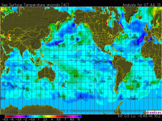
Figure 1
The direct link to that archived map is here.
The color-coding of the Unisys maps of course makes the data appear cool, but even so, the June 2013 sea surface temperature anomalies, based on the Reynolds OI.v2 data, are in fact cool off the southwest coast of Europe. As shown in Figure 2, the data for the coordinates of 35N-55N, 20W-5E haven’t been that cool since 1993-94.

Figure 2
But—there’s always a but—the sea surface temperature anomalies to the north and northwest of Europe (55N-75N, 20W-55E) are running on the warm side. Refer to Figure 3.

Figure 3
As a whole, though, the sea surface temperature anomalies for European coastal waters are pretty typical of the values for the last decade, as shown in Figure 4.

Figure 4
And of course, there’s nothing in the ocean heat content data and the satellite-era sea surface temperatures to indicate that manmade greenhouse gases were responsible for the warming of the global oceans. If that topic is new to you, refer to the illustrated essay “The Manmade Global Warming Challenge”.
A COUPLE OF CLOSING QUESTIONS
Figure 5 is a map that captures the June 2013 sea surface temperature anomalies for the portions of the Arctic Ocean, Mediterranean Sea and North Atlantic discussed in this post. While the warm anomalies at high latitudes are likely the result of a weather pattern, it almost appears as though Iceland is somehow responsible for part of the warming.

Figure 5
And that leads to my questions:
Has anyone ever seen a study of the impacts of volcanic ash and pumice on the optical properties of sea water and/or on sea surface temperatures? And has anyone seen a study of the impacts of volcanic ash from recent high-latitude eruptions on the albedo of sea ice?
SOURCES
The Sea Surface Temperature anomaly data used in this post is available through the NOAA NOMADS website:
http://nomad1.ncep.noaa.gov/cgi-bin/pdisp_sst.sh
or:
http://nomad3.ncep.noaa.gov/cgi-bin/pdisp_sst.sh?lite=
I am also struck by the relative coolness of the swath of the Atlantic where the hurricanes seem to form.
But, but – look at the anomaly off Manitoba / Nunavut! There’s the proof of CAGW right there! In fact, it’s worse than we thought! Soon we’ll have palm trees growing there and coral reefs in Hudson Bay!
Starzmom, good observation. Potentially the dearth of large hurricanes will continue. Welcome news to me on the east coast.
Very confusing color scheme.
Of course, I’m a man so I can’t tell one color from another anyway, but the -2 and +10 color looks almost identical to me.
I assume we are seeing the minus numbers in the N. Atlantic.
http://www.cefas.defra.gov.uk/our-science/observing-and-modelling/monitoring-programmes/sea-temperature-and-salinity-trends/presentation-of-results/station-18-dover.aspx
Thanks Bob.
James Cross says:July 13, 2013 at 5:53 am
The colors do look identical. Why they don’t use green, middle of light spectrum, for neutral, and tend toward the red end for hot and blue end for cold. Seems simple enough. The NWS uses a spectrum that keeps shifting the temperatures attributed to a color, makes me nuts.
The Iceland question is very interesting.
Looks like most colors are used twice. Since it is summer in Northern latitudes without having additional info. I would just have assumed that it was the higher ones that applied.
Strange how the NCEP data seems to be at odds with the Unysis chart. As seen on the sea ice page http://polar.ncep.noaa.gov/sst/ophi/color_anomaly_NPS_ophi0.png
The centre of the north icelandic hot spot is right over the where the mid-atlantic plates are pulling apart. Perhaps magma close to the surface is warming the water there, from below.
Underwater volcanoes ? Iceland is very active geologically
it almost appears as though Iceland is somehow responsible for part of the warming.
It is not Iceland itself but Kolbeinsey Ridge I have posted about few times in pst.
http://www.vukcevic.talktalk.net/CET-NV.htm
it almost appears as though Iceland is somehow responsible for part of the warming.
It is not Iceland itself but Kolbeinsey Ridge I have posted about few times in past.
http://www.vukcevic.talktalk.net/CET-NV.htm
“UNISYS Current Sea Surface Temperature Anomaly Plot”
http://wattsupwiththat.com/reference-pages/climatic-phenomena-pages/enso/
Why the two maps?????????
Hey Kev-
Here’s your missing heat.
An interesting article. On the color scheme topic I agree with James Cross and Steve Keohane. I am somewhat color challenged (my wife doesn’t have to dress me) so am easily confused by many temperature charts. In Figure 1 the color scheme for -6.5 to -2. seems to be repeated for +5.5 to +10. Are there no standards or commonly accepted practice for color schemes for figures such as these? I know color has the most impact but for clarity I would prefer contour lines with temperature displayed at the center of each critical region.
I agree : near bordeaux the weather is rather hot but (32°C) non exceptional. Nevertheless the ocean is cold less than 18 C !!!
Ok, visualize a “sarc tag” at the end of my post immediately precedent, this one. I say this just in case someone thinks I was serious and would take me to task… it would be a stretch to consider the warmed waters shown in the graphs as accounting for Trenberth’s missing heat.
Anthropogenic Global Warming heats up the deep ocean, disrupts the Gulf Stream and causes an Ice Age in Europe. Shows my model. More research is needed. Please send money. /sarc
I agree with above comments about the color chart. With the technology available, someone must REALLY want to be incompetent to produce a chart like that.
(That of course does not reflect on Bob, or his effort in bringing this post to us.)
Bob
Anomalies of fractions of a degree be blowed. I can tell you from first hand experience 10 minutes ago that the ocean 100 yards from my house in the South West Tip of England is 3 degrees Centigrade cooler than it ‘usually’ is.
Mind you we have had a prolonged sunny spell-our first for 7 years and it may warm up enough in the next few weeks for people to take off their wet suits.
tonyb
If volcanic ash in sea water – or submarine volcanicc emanations were responsible for the warmer waters, the warmists would say that CO2 induced back radiation caused the warming, not SI, another case of unexpected catastrophic consequences of the burning of tarsands brought to a refinery by a pipeline.
And they would get a multi-year grant to study the issue.
Updated
http://www.vukcevic.talktalk.net/CET-NV.htm
link, since the older version was posted
Bob,
Thanks for this post, I don’t normally study these maps but this one is interesting and I spent some time studying it.
Given the temperature anomalies shown for the Atlantic, I am confused as the hurricane predictions based on claimed higher ocean temperatures. Possibly you can clarify this, Bob.
I do know the Ocean temperatures off Atlantic City NJ are unusually cold for this time of year at 60 F which is consistent with the figure you provided.
http://www.nodc.noaa.gov/dsdt/cwtg/catl_tmap.html
Although I initially missed it, there are H’s by the positive anomalies and L’s by the negative anomalies so the Atlantic off the US is below normal not above.
The potential confusion in the color code is unnecessary.
http://www.meteociel.fr/accueil/sst.php
for Yves de mars
A bit more than 18°C on this map; I have even seen one giving 23°C,what is above the mid july mean ; but probably , it is to satisfy the tourists
Isn’t the Iceland anomaly just the Gulf stream but it then leads to the question what is different this year vs past years?
The hot spot in Hudson bay north of Churchill Manitoba is a puzzler and one that warrants further examination since my first guess would be that river discharge temps are being compared to sea water temps somehow … likely changes in sampling points which yield yet another “its worse than we thought” alarmist data point 😉
“But, but – look at the anomaly off Manitoba / Nunavut! There’s the proof of CAGW right there! In fact, it’s worse than we thought! Soon we’ll have palm trees growing there and coral reefs in Hudson Bay!”
Actually, that is easily explained – the temperature anomaly is due the unexpectedly large population of polar bears (versus the warmists’ predictions) urinating in Hudson Bay during their summer vacations. 😉
Catcracking says: “Given the temperature anomalies shown for the Atlantic, I am confused as the hurricane predictions based on claimed higher ocean temperatures. Possibly you can clarify this, Bob.”
I didn’t notice this year if the predictions of an above-normal hurricane season were based on higher sea surface temperatures, but sea surface temperature anomalies are still a little above normal in the Main Development Region (10N-20N, 80W-20W):
http://i42.tinypic.com/fxs579.jpg
They’ve dropped a little since my last full post about the sea surface temperatures and anomalies of the hurricane development regions:
http://bobtisdale.wordpress.com/2013/05/19/hurricane-main-development-region-sea-surface-temperatures-anomalies-plus-a-couple-of-other-regions/
The factor that I know was mentioned in the prediction of an above-average hurricane season was that we weren’t expecting an El Nino to form this season, and we still aren’t. El Ninos in the tropical Pacific suppress hurricane formation in the tropical North Atlantic. So the absence of an El Nino would contribute to the higher number of hurricanes predicted.
Regards
The higher ocean temperatures, not CO2, in the Arctic region would account for more ice melting there.
This colder water off the coast of Europe may explain why AMO has been dropping since November 2012 at 0.484 to 0.079 in June 2013
Keep in mind what is not visible. There is continuing unusual polar atmospheric flow, eg. with reversed wind directions from usual. Given wind affected water flow tends to 90 degrees from the intuitive direction (Coriolis) maybe this is at work.
Over the past week a huge great storm has passed between Iceland and Scotland/Norwegian coast on it’s way north east, might be related.
I spotted another plummet in data which is totally unconnected but put it down to error or just an oddity to be considered sometime.
Bob,
Thanks for the clarification.
Here are several links that discuss hurricane for 2013 due to warmer ocean temperatures which must be the basis for my perception..
Probably not reliable sources (CNN)
http://www.cnn.com/2013/05/23/us/hurricanes-prediction
http://www.climatenewsnetwork.net/2013/05/hurricane-warning-is-linked-to-climate/
Peter Dunford says:
July 13, 2013 at 6:11 am
“The centre of the north icelandic hot spot is right over the where the mid-atlantic plates are pulling apart. Perhaps magma close to the surface is warming the water there, from below.”
Lots of tectonic activity offshore north Iceland back in April.
http://www.jonfr.com/volcano/?p=3591
herkimer says: “This colder water off the coast of Europe may explain why AMO has been dropping since November 2012 at 0.484 to 0.079 in June 2013”
The peak in the North Atlantic sea surface temperature anomalies last November…
http://bobtisdale.files.wordpress.com/2013/07/07-no-atl.png
… was likely the result of the short-term El Niño conditions earlier last year:
http://bobtisdale.files.wordpress.com/2013/07/02-nino3-4.png
Regards
This is excellent news – we are planning a tour by river boat from Europe to the Caspian Sea and the last thing we need to see is a projection of miserable cold. At least I hope that is what the colors mean. I don’t think I’ve ever seen a color map wrap around quite like this one does. Can I get a second opinion?
l see this fine weather we have been having in the UK over the last week has started to warm the waters around the UK. This helps to confirm what l have seen else where. That the local weather can have a real impact on sea surface temps.
mwhite says: July 13, 2013 at 6:27 am
“UNISYS Current Sea Surface Temperature Anomaly Plot”
http://wattsupwiththat.com/reference-pages/climatic-phenomena-pages/enso/
Why the two maps?????????
They are just two versions, Bob is using the original version;
http://weather.unisys.com/surface/sst_anom.gif
whereas on the ENSO page we use the “new” version:
http://weather.unisys.com/surface/sst_anom_new.gif
The “new” version makes things look warmer, and lost a bit of the finer detail the original affords, but as James Cross says: July 13, 2013 at 5:53 am notes, the original version has a “Very confusing color scheme.”
In the Netherlands we have had 6 consecutive months with temperatures below normal, thanks to the cold North Sea. Please tell me that this is just noise in the climate system and that the expected warming will soon continue. 😉
Thanks, Bob. Good post. This chaotic weather!
Also:
The Tropical Meteorology Project
(Dr. Philip J. Klotzbach, Dr. William M. Gray, Colorado State University)
Extended Range Forecast of Atlantic Seasonal Hurricane Activity and U.S. Landfall Strike Probability for 2013 (.pdf, June 3 ’13):
We continue to foresee a very active 2013 Atlantic hurricane season. The tropical Atlantic remains very warm, and we do not anticipate development of a significant El Niño. Given the above-average forecast, we are calling for an above-average probability of United States and Caribbean major hurricane landfall.
See http://hurricane.atmos.colostate.edu/Forecasts/2013/apr2013/apr2013.pdf
The Polar Front is normally just north of Iceland. If it retreats a few hundred kilometers the result will look like a narrow swath of strong warming.
By watching the fulldisk satellite images,what looks to be the reasons for the current low hurricane activity. ls the east to west airflow across the mid Atlantic looks to have become rather weak and waving. lts this that seems to be making it hard for hurricanes to form. Also the heavy rain along the eastern side of the USA this summer has taken a lot of the heat out of the waters around Cuba and the SE of the USA.
I think underwater volcanoes do play a part, maybe small, in the sea ice shrinkage in the Arctic. The obvious one has to be off of Thule, Greenland (far north west). Also, it looks like there is one northwest of the Svalbard islands (Longyearbyen side). Thule in particular will have heavy sea ice north and south of it but open water for some time. Maybe their is a warm river due to geothermal activity nearby.
There has been an incredible warm spell on northern europe this summer, which propably explains the warm ocean east of Iceland.
The color scheme of the first graph almost looks as if they didn’t expect there to be cold anomalies anymore…
Has anyone ever seen a study of the impacts of volcanic ash and pumice on the optical properties of sea water and/or on sea surface temperatures? And has anyone seen a study of the impacts of volcanic ash from recent high-latitude eruptions on the albedo of sea ice?
Pumice is light coloured and floats for a period. Clearly it will have a large albedo effect, until it sinks. I don’t recall any reports of pumice off Iceland, and it would take a lot to affect SSTs.
The north south SST anomaly differences are due to recent weather patterns. That they start east of Iceland is probably just a coincidence. Note the warm anomalies in the shallow Baltic and in the shallow seas around the Kola Peninsula. This indicates above average sunshine is the cause.
Have you seen this article?
http://oceanrep.geomar.de/4684/
The role of airborne volcanic ash for the surface ocean biogeochemical iron-cycle: a review
Abstract
Iron is a key micronutrient for phytoplankton growth in the surface ocean. Yet the significance of volcanism for the marine biogeochemical iron-cycle is poorly constrained. Recent studies, however, suggest that offshore deposition of airborne ash from volcanic eruptions is a way to inject significant amounts of bio-available iron into the surface ocean. Volcanic ash may be transported up to several tens of kilometers high into the atmosphere during large-scale eruptions and fine ash may stay aloft for days to weeks, thereby reaching even the remotest and most iron-starved oceanic regions. Scientific ocean drilling demonstrates that volcanic ash layers and dispersed ash particles are frequently found in marine sediments and that therefore volcanic ash deposition and iron-injection into the oceans took place throughout much of the Earth’s history. Natural evidence and the data now available from geochemical and biological experiments and satellite techniques suggest that volcanic ash is a so far underestimated source for iron in the surface ocean, possibly of similar importance as aeolian dust. Here we summarise the development of and the knowledge in this fairly young research field. The paper covers a wide range of chemical and biological issues and we make recommendations for future directions in these areas. The review paper may thus be helpful to improve our understanding of the role of volcanic ash for the marine biogeochemical iron-cycle, marine primary productivity and the ocean-atmosphere exchange of CO2 and other gases relevant for climate in the Earth’s history.
Looks like ash as fertilizer is the hot new research area:
http://www.atmos-chem-phys.net/10/3891/2010/acp-10-3891-2010.pdf
[…]it almost appears as though Iceland is somehow responsible for part of the warming.
Let’s hope not. Iceland sending out a huge plume of warm water can’t be a good sign.
taxed says: “By watching the fulldisk satellite images,what looks to be the reasons for the current low hurricane activity.”
We’ve had three named storms storm so far this year, and that’s outpacing an average (1966-2009 base) year.
Graph:
http://www.nhc.noaa.gov/climo/images/cum-average_Atl_1966-2009.gif
From this webpage:
http://www.nhc.noaa.gov/climo/
Regards
“There has been an incredible warm spell on northern europe this summer, which propably explains the warm ocean east of Iceland.”
I suspect Hannuko lives in Finland, a bit further west in Norway-Sweden it has been a quite average summer so far.
@ Bob Tisdale
The three storms we have had so far have been TS rather then hurricanes.
Now don’t get wrong am not saying there is no risk of storms forming. Just that if the current conditions in the mid Atlantic stay in place. Then the risk of large hurricanes forming in the mid Atlantic will remain low.
forgot to put in the word “me”.
From the Manmade Global Warming Challenge”>: “You’ll Often See Statements to the Effect of: 90% of the Manmade Global Warming Goes into Warming the Oceans.”
I don’t know about manmade global warming (and for serious reasons I don’t think there’s a significant “manmade global warming”, and definitely not anything like significant “manmade, warming of the oceans”) but in my opinion it is true that:
1. Even the oceans cover only a bit over 2 thirds of the Earths surface, almost 90% of the solar radiation reaching the Earth’s surface absorbed there and converted to heat is absorbed and converted to heat in the open oceans by solar radiation extinction in the so called epipelagic zone (where the solar irradiation shortwave spectra flux is still significant) of the ocean (0~200 m)
2. This is i.e. given by very low ocean reflectivity even at relatively high angles of insolation – i.e. due to ocean waviness – and also due to the fact the bulk of the open oceans is at latitudes below 65° (where the average water reflectance even at zero waviness is ~0.03).
3. Due to air/water interface refractive properties the ocean waviness considerably lowers the net ocean reflectivity near terminator, so with even slightly wavy ocean its net reflectivity goes considerably down at lower incidence angles when compared to waveless water. Effectively the mean wavines of the ocean causes that even at high angles of insolation incidence close to 0° the average water reflectivity closes to 0.5 (although for waveless water it would be close to 1) and so the average ocean reflectivity comes out considerably lower than the often mentioned ~0.08 – which is in fact the average reflectivity value for ~2-90° incidence angle. -But, I reiterate: the open ocean we find at 0-65° latitudes stripe, for which the average reflectivity is ~0.05. Which means unlike landmass the ocean absorbs well 95% of the solar radiation reaching its surface converting it mostly immediately to heat.
4. The solar irradiation is significantly reaching relatively deep (~up to the 200m depth) which is given by exceptional transparency of the water for solar spectra (unlike almost all the solids covering the landmass) including UV. So the sun directly and immediately warms the sea water to considerable depth of the ocean surface layer (unlike the solids covering the landmass, which are heated to depth much more by much slower heat conduction from the surface heated to relatively much higher temperatures). The ocean surface layer is moreover quite well mixed by turbulences and so although the intensity of the penetrating shortwave solar radiation diminishes exponentially with depth the surface layer has more or less same temperature.
5. On the other hand the water is order of million times more opaque to the mid-IR spectra at which the atmosphere radiates than to the solar spectra. Which means the atmospheric mid-IR radiation can’t significantly penetrate and warm the water deeper than order of tenth of milimeter of the ocean surface skin – where it mostly contributes heat to evaporation-water vapor (which then transports the latent heat up to the atmosphere by convection), and therefore a GHE, even if considerably enhanced by elevated CO2 concentration, can’t have a significant net direct warming effect on the oceans. (And it is physically impossible even indirectly by way of heating air and the heat conduction from the heated air-to water. -The surface atmosphere layer has lower average temperature than ocean surface and therefore can’t cause net heating of the ocean by conduction – such a conductive heat transfer would be direcly in violation of the 2nd law of thermodynamics.)
6. According to the Solanki TSI reconstruction the TSI (upward) trend for the 20th century was several hundreds of miliWatts per square meter per century (~0.69 W/m^2/century). And even it looks like a small number, if one calculates how much ocean heat content change the upward TSI trend would cause in the 100 years in the ocean surface layer (heat surplus ~0.4+ GJ per square meter of the ocean surface) and how much it would warm the ocean epipealgic zone (believe it or not, you can calculate it for yourself) the result is well in order of magnitude consistent with the observed sea surface/epipelagic zone temperature change in the 20th century – while the amounts of surplus heat at play are several orders of magnitude higher than in the atmospheric boundary layer, so one can conclude that the sun heating the surface layer of the ocean was in fact the chief factor causing the slight surface warming in the 20th century.
All this and especially the point 5. implies that the cited “90% of the Manmade Global Warming Goes into Warming the Oceans” is physically impossible – at least surely for the proposed GW mechanism of the anthropogenic CO2 causing allegedly the warming through the slight enhancing of the GHE.
About Iceland there have been a quite high quake and possible underwater vulcano acivity on the northeast corner of the country it have decreased latest month but before that there was a long period of activity ( This area) http://en.vedur.is/earthquakes-and-volcanism/earthquakes/tjornes-large/ im not sure at all how much energy thats released by this but it struck me that the heatsource seems related the activity area. Following link is a big event in April this year.
http://earthquake-report.com/2013/04/09/volcano-activity-of-april-8-2013/