Guest Post by Willis Eschenbach
The Argo floats are technical marvels. They float around below the surface of the ocean, about a kilometre down, for nine days. On the tenth day, they rise slowly to the surface, sampling the pressure, temperature, and salinity as they go. When they reach the surface, they radio home like ET, transmit the data from the instrumental profiles, and they drop back down into the eternal darkness for another nine days. The first Argo floats were put into the ocean in the year 2000. In 2007, the goal of 3,000 floats was achieved.
In “Krige the Argo Probe Data, Mr. Spock“, I discussed some issues with the Argo floats. Then in “Decimals of Precision” I discussed and strongly questioned the outrageous error claims made by the Argo researchers. They say that we can detect a temperature change with an error of 0.004°C per year in the top 1,800 metres of the ocean. I say no way, not yet.
In a comment on that thread, I posted a graphic showing the current distribution of the Argo floats, shown below as Figure 1.
 Figure 1. Distribution of Argo floats as of February 2012. SOURCE
At that time I remarked on the distribution, saying:
However, I do see one place that they are not covering, and strangely, it is a crucial location—the intertropical convergence zone (ITCZ). Surface water around the ITCZ is heated. When it is heated it expands, which creates a gravitational trend downhill towards both poles. As the surface water is heated and moved polewards, it is replaced with deep oceanic water from below. So I’d say your suspicions are correct for at least that area.
In the Pacific, the ITCZ is generally found roughly ten degrees or so North of the Equator. You can see the blank area in Figure 1 just above the Equator. My speculation was that the blank area was not a random occurrence. So … I set out to take a look at where the Argo floats have sampled and where they haven’t sampled. I didn’t realize what I was getting into.
It’s a dang nuisance to get all the Argo files. They are available at the Global Argo Data Repository. The problem is that there have been over 8,000 individual Argo floats … and the rocket scientists at NOAA have decided to make the data available as one file per float, eight thousand individual files … grrr …
So I thought it might be of interest to describe how I went about getting the data. I haven’t gotten all of it, at the moment I’m somewhere between 5,000 and 6,000 files downloaded.
The first step in the process is to get the URL addresses of all of the files, which are shown on the web page at the link given above. To get the text of the URLs, remember that these are all listed in the “source” file that created that web page. Under the “View” menu (on the Mac, at least) you have a choice called “View Source”. This “source file” is a text file that contains the HTML information on how to make up the page, including all of the URLs of all the links on the page.
So … the first file listed on the web page is “IF000550”. I searched the source file for that, it’s at the start of the table. A similar search for “9018420”, the last file listed on the page, found me the end of the table.
I copied all of that information from the start to the end of the table from the “Source” document, and pasted it into a text processor. The end of an HTTP address is marked by the close code “”. I did a global search for that phrase, and replaced them all with a carriage return (“^p” in Microsoft Word). That left the text broken into short sentences suitable for pasting into Excel.
So I copied all of the resulting text, and pasted it into Excel. From there, it was easy to sort the lines. I wanted lines containing addresses that looked like
http://www.nodc.noaa.gov/argo/data/coriolis/7900073.tgz
These are the files with the actual float-by-float temperature profiles. I sorted them out, there were about 8,500 of them or so.
That gave me the list of all of the URLs of the files I was interested in. I saved those as a comma-delimited file, and opened it using the computer language “R”.
Using R, I was then able to automate the download process, having the computer download the files one after another. The one thing you need to do is leave gaps in your file requests. If you just request one file after another with no pause, you may get mistaken for a denial-of-service (DOS) attack on their server. So I put in a half second pause in after every five downloads. This adds about 12 minutes on 8,000+ downloads, not bad.
So that’s how I’m doing it. Once I get it all downloaded, I’ll put it together in some more reasonable format and stick it back out on the web, so people won’t have to go through that madness for the data.
In any case, I have downloaded the coordinates of all of the temperature profiles ever done by any Argo float. Remember that I started out on this hegira to see if my eye were good, and if there was a sampling inconsistency in the Pacific just above the equator.
Figure 2 shows how many samples have ever been taken everywhere in the global ocean. There have been a total of about 890,000 Argo temperature profiles taken to date. Sounds like a lot … but the ocean is a huge place. I began by counting the number of observations per gridcell on a 1° x 1° grid basis. I then standardized them by area as the number of temperature profiles taken per 10,000 square km. I picked this size for a couple of reasons. First, it’s close the area of a 1° x 1° gridcell at 40° North. This reduces distortion of the counts. And second, it’s a square which is a hundred kilometres (about sixty miles) on a side, so it can be easily visualized. It is a huge expanse of ocean.
 Figure 2. Number of temperature profiles ever taken by Argo floats in various areas of the ocean. Percentages in the second row refer to the percentage of the total ocean area having that number of temperature profiles. Percentages in the third row refer to the percentage of the ocean area from 60°N to 60°S having that number of temperature profiles. Click on image for larger version.
So … what are we looking at in Figure 2? We are seeing which areas of the ocean are better sampled, and which are more poorly sampled.
The red areas are those parts of the ocean which have never been sampled at all by Argo floats. In some cases, such as the area around Indonesia, or the east side of the bottom half of South America, it is because the ocean is shallow there. Up north it’s because of ice. And down south? It seems the currents don’t carry the floats down that far. This makes sense because the cold surface waters are sinking around Antarctica and flowing north in that region, carrying the submerged floats with them away from Antarctica.
In other areas, such as off the westernmost point of South America and the area on the western side of South Africa, the cause for the lack of samples seems to be the local upwelling in the areas. Presumably, since the water is radiating outwards at depth as well as at the surface, the floats are moved away from that area.
The areas in orange, another 10% of the global ocean, have only ever been sampled from just once to eight times. So a quarter of the ocean has either never been sampled, or has been sampled less than eight times per 10,000 sq. km, since the beginning of the Argo program in 2000.
In other words, a quarter of the global ocean has been sampled less than once a year per 10,000 sq. km. by Argo floats … yet they claim an error of only a few thousandths of a degree in the global average.
To get around part of this problem, sometimes the Argo data is used solely from 60° north of the Equator to 60° south. This eliminates some of the problem, but there is still 8% of that ocean area from 60°N/S that has never been sampled at all. How can they possibly claim to know the temperature of that huge volume of ocean to within ± 0.004°C, when 8% of it has never been sampled at all, much less adequately sampled? Another 8% of the ocean 60°N/S is sampled on the order of once a year … again, nowhere near adequate for the claimed accuracy.
What else can we see? There are areas which are way oversampled compared to the rest (cyan color, more than 96 measurements/10,000 sq km), places where it is clear that the floats tend to “get stuck”. These include the ocean around Japan, parts of the Mediterranean, the Bay of Biscay off France, the south tip of Greenland, the northern Indian Ocean, and the Gulf of Alaska. It appears that the Argo floats get trapped in these bays, corners, and dead ends. Presumably the wind is driving them onshore when they are at the surface, and they move offshore when they are at depth. This keeps them in the same area, leading to the large number of samples.
Finally, the hunch that started me on this quixotic quest is confirmed. There is indeed a band which is only infrequently sampled just above the Equator in the Pacific. There have been many more samples taken just above and below that band. The infrequently sampled area is also the area where the El Nino upwelling occurs. I hardly take this as a coincidence.
CONCLUSIONS
• The sampling of the oceans is by no means as uniform as I had expected. Part of the ocean is undersampled, sometimes badly so, compared to other areas. Half of the global ocean has been sampled less than 20 times per 10,000 sq. km, and 14% has never been sampled by Argo floats at all.
• Even when we look at just the area from 60°N/S, half the ocean has been sampled less than 24 times per 10,000 sq. km, and 8% is unsampled.
• The area of the El Nino phenomenon is a critical area for the regulation of planetary heat loss. Oceanic heat content in this area can change quite rapidly. However, parts of it are woefully undersampled.
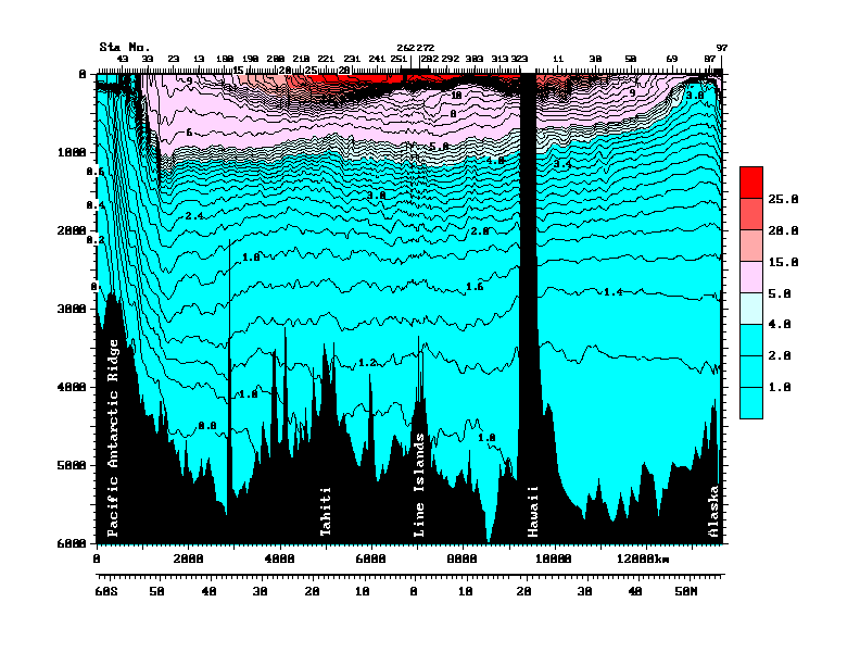
• Finally, the older Argo floats sample either down to 1,000 metres, and intermittently go to 1,500 metres depth. The newer ones go down to 1800 metres. Which is quite deep, about a mile down. But the estimates of oceanic heat storage include the whole ocean. Figure 3 shows a pair of transects from Antarctica (on the left) to Hawaii, and then Hawaii to Alaska on the right, to give some sense of scale.
![]() Figure 3 (Figure 10 from cited source.) North/South Pacific transect at 150°W. ORIGINAL CAPTION: Vertical section of potential temperature (°C) along 150°W from data collected in 1991-1993 as part of the World Ocean Circulation Experiment. Data north of Hawaii were collected in 1984 (Talley et al., 1991). Potential temperature is the temperature a parcel of water would have if moved to the sea surface with no change in heat content, and is lower than measured temperature since temperature increases when water is compressed due to the high pressure in the ocean. Source and Image
Figure 3 (Figure 10 from cited source.) North/South Pacific transect at 150°W. ORIGINAL CAPTION: Vertical section of potential temperature (°C) along 150°W from data collected in 1991-1993 as part of the World Ocean Circulation Experiment. Data north of Hawaii were collected in 1984 (Talley et al., 1991). Potential temperature is the temperature a parcel of water would have if moved to the sea surface with no change in heat content, and is lower than measured temperature since temperature increases when water is compressed due to the high pressure in the ocean. Source and Image
The Argo floats operate mostly in the warmer area up top of Figure 3, above the lower thermocline (light blue). Average depth in this entire transect is much deeper than that, about 5,000 metres. So the Argo floats are measuring less than a quarter of the water in this part of the Pacific basin. Makes the whole question of oceanic heat content kinda iffy.
Anyhow, that’s my first look at the question of the float distribution. I have some other projects in mind once I get the data downloaded. I’ve been downloading while the Super Bowl has been on, I’m up to 6,000 files downloaded, only 2,500 or so to go … but tomorrow is Monday, it’s back to my day job in construction pounding nails, that slows the science down. I just want to find someone to pay me for my research. Where are Exxon and the Koch Brothers when I need them?
My best to everyone,
w.
PS: I was quite happy with my map. It’s the first one I’ve done of a 1° x 1° grid. I found that to get it to print properly, I could use one dot per 1° x 1° gridcell. But to make it work, I had to size the dot by the cosine of the latitude. Took me a while to figure out how to do that in “R”, I’m kind of an R klutz, I only learned it a few years ago. But I made it work.
My experience of the ITCZ is that it is a line of violently convecting cumulonimbus clouds which contain enough energy to build way above the tropopause. These clouds were not to be flown into and the clear air turbulence even outside these clouds was severe enough to try to climb through which we tried once and at 620,000ft we gave up with clouds building way above us.
The route met report we submitted was not believed. It was 1966 and our aircraft a Vulcan2 flying over the Indian Ocean.
Fantastic work.
What is more obvious than the lack of sampling around the equator is the blue line above it. it is almost as if someone had drawn the line!
Ah, Willis, the magic a shell script can work! I’m downloading all 8000 now, shouldn’t take long. Drop me an email and I’ll get you a .zip of them all.
As always, your tenacity is a wonder to behold.
Wonderfull work. Congratulations.
Excellent piece of research.
One would think that the curators would have a better handle on the appropriate degree of precision.
“An error of 0.004°C per year” ? For what it’s worth, I relate the following. Conclusions, if any, I leave for others to draw.
At one time as part of some research, I needed to control the temperature of a few liters of water in a laboratory to +/-0.001. After much experimentation I found that the only way of doing this was to use a powerful circulation pump (albeit adding heat to the system) together with a cold source plus a hot source that provided heat proportionate to the difference between he actual temperature and the required temperature. This finally worked! In a large volume of water ( > 10 liters or so), thermal currents arose irrespective of stirring and a) made it impossible to achieve the required temperature and b) undermined the significance of the recorded temperature for one had to ask “For which volume of water is this ‘result’ applicable?”
Thanks for your great post as well as great effort, Willis.
So, a measurement of about 3/4 of the area and about 1/4 of the depth, roughly 3/16 of the volume and then not well sampled.
However approximate this is, it’s a huge improvement on pre Argo data
Viva the sceptics!
620,000ft
I think you might be wrong by a factor of 10
Nice work Willis. Its good to get a properly considered perspective on OHC measurements. And in the light of this, imagine how bad the data from the XBT days was!
at 620,000ft we gave up with clouds building way above us.
The route met report we submitted was not believed.
———————————————————————-
I find it very hard to believe as well. 620,000 ft is about 190KM up – into the lower end of Low Earth Orbit and half way to the ISS. I’ve never heard of either aircraft or clouds extending into the mesosphere, let alone 100KM above it in the thermosphere
Did you perhaps mean 62.000ft?
Excellent report, Willis! Most illuminating. What relation do the placements of the floats as they report data have with their original placement in the ocean? Put another way, can anyone tell how far the float has moved–and in what directions–since it was installed? And why not anchor the silly things to the ocean bottom to keep them from moving away (joke)?
Nice article Willis, very informative and lots of potential for further analysis.
Wilils, there is a Firefox (Chrome and Safari too) extension known as “DownloadThemAll!” (https://addons.mozilla.org/en-US/firefox/addon/downthemall/) that works wonderfully. Set the directory to put the files in, add the txt and tgz file filters, configure the download threads (I choose 3) and limit the bandwidth (I chose 700 KiB/s. Presto. It’s running at between 10 to 112 KiB/s actually. It’s taken just a few minutes to get 1251 of the 16854 files so far. No fuss no muss.
HTTrack can get all files on a web page into a local Directory. It is open source at http://www.httrack.com
Thanks
JK
Rubbish altimeters in them there Vulcan2s John.
Anyway Willis, thank you for a very good article – how do you find the time to do all this – and write lots of articles as well? – I am impressed.
Keith Gordon
Very interesting article as usual from Willis, and what a huge amount of work he has put in to further our understanding, we are indebted to him, It does point out the difficulties in measuring global ocean heat content. I will enjoy reading this several times. But this quote from the article particularly jumped out at me.
“Potential temperature is the temperature a parcel of water would have if moved to the sea surface with no change in heat content, and is lower than measured temperature since temperature increases when water is compressed due to the high pressure in the ocean”.
Can anyone explain if that pressure heat relationship happens in the ocean why could it not in the atmosphere. I am just genuinely interested in hearing the views of our contributors on this matter. Hope it’s not off topic!
Keith Gordon
“The Argo floats are technical marvels. They float around below the surface of the ocean, about a kilometre down, for nine days. On the tenth day, they rise slowly to the surface, sampling the pressure, temperature, and salinity as they go. When they reach the surface, they radio home like ET, transmit the data from the instrumental profiles, and they drop back down into the eternal darkness for another nine days. The first Argo floats were put into the ocean in the year 2000. In 2007, the goal of 3,000 floats was achieved.”
What a wonderful scientific project! Methinks, this is money well-spent, a job well-done.
This is how humanity tries to make sense of the natural world, kids: observe everywhere high and low, get data, accumulate data, and see if you can locate any pattern in the data. These are the first steps in any scientific investigation.
Question: There seems to be a proliferation of ARGO floats on the Eastern Coast of Japan. Is that because of the intense seismic in the area?
and
How are these floats kept so spread out in the swirling currents of the oceans? I take it there is now a permanent crew of technicians on boats who go around picking up these floats and re-locating them thousands of miles away after a health check-up, re-charge and repair.
Hi Willis, I share you concerns about the ARGO floats, especially I think the precision claim (“to detect a temperature change with an error of 0.004°C per year in the top 1,800 metres of the ocean”) seems ludicrous to me.
Just two thoughts:
1. In the shallow areas there is no deep ocean. If the ocean depth is less than 1.800 meters, there is nothing to sample. (It is the same as not measuring the ocean temperature at a land location.) You should not use a map of the oceans surface, but a map that shows the parts of the ocean that are deeper than 1.800 meters.
2. If the density of coverage does not change over time, then the ARGO floats could yield a useful number – albeit still with the question whether the uncertainty is low enough to make useful conclusions. Bill Briggs posts about problem with “Prediction of Models” comes to my mind.
(R seems like a useful tool, I should really learn it too.)
Is it possible that the lack of data from the ITCZ is because the upwelling means the buoys are pushed out of that area?
Might be 20,000 feet , I think 62,000 feet is beyond the Vulcan ceiling.
Tom and pwl;
“What? why use a crane and wrecking ball, or a jackhammer, when I got this here perfectly good 16-lb sledge? ”
Heh.
Someday maybe the mathemagical AI at Wolfram Alpha will respond to a natural language request, “Send me all the Argo data files in a spreadsheet.” Then tell Eureqa Mk IV, “Find out what all this means.”
😀
WOW !!!
8000 files. One at a time !!!
Interesting post, Willis. I am looking forward to the next installment in this series!
What you talking bout Willis?
As a Brit, I’m somewhat puzzled that all of the water around the British Isles (North Sea, Channel, Irish Sea) are Argo-free zones. Does the ‘shallow waters’ exception apply to ANY area within the continental shelf? Fantastic work – the degree of diligence required is astonishing.
Hi Willis, Thanks for an interesting article.
On the error of 0.004°C per year. I suspect this is the rated accuracy of the Argo thermometer
and not the accuracy of the sampling of the oceans. Its the sort of thing that some climate scientists seem to do. Statistics not being their strength ;-).
/ikh
OK well, that’s very nice but you do know that the second you report something “The Cause” doesn’t like (and it may already be too late), you now you’ll be accused of hacking and stealing the data, right? Since it wasn’t officially presented on the page as specific downloadable files? You had to go in and do a bunch of those computery HTML thingys and other hacky acronym stuff like URLs and PB&J to get the files. Yeah, you might want to buy a cheap, used laptop, put the data there and then hand that to the police when they show up to collect it for their investigation.
A bit more accurate than a bucket on a rope thrown over the side every 6 hours (90 miles travelled) and an apprentice shoving a mercury thermometer in it then trying to remember the number as he runs back up 5 flights to the bridge. They claim accuracy to 2 decimal places for the results of that exercise.
Keith Gordon says:
February 6, 2012 at 4:03 am
Can anyone explain if that pressure heat relationship happens in the ocean why could it not in the atmosphere.
__________________________________________________________
The short aswer is ‘yes.’ There is an interchange between gravitational potential energy and kinetic energy, the latter affecting temperature.
The terminolgy “heat content” should be “thermal energy content” because total thermal energy includes potential energy, whereas using the term “heat content” leads to potential energy being overlooked. In any event, heat is not energy: rather it is energy in transit.
Tony Mach says:
February 6, 2012 at 4:07 am
Hi Willis, I share you concerns about the ARGO floats, especially I think the precision claim (“to detect a temperature change with an error of 0.004°C per year in the top 1,8000 metres of the ocean”) seems ludicrous to me.
Years ago I worked for an instrumentation company that developed borehole instruments for measuring physical properties such as resistivity, radioactivity and temperature.
Temperature was tricky for several reasons. First, the sensor (a small thermistor) was so small you had to mount it onto something larger just to work with it (we used a needle). They were so sensitive (+/- 0.0001oC) that we could only “log” the borehole in the down direction, once a day because the probe would disturb the natural gradient. We easily achieved sensitivities of +/-0.001 degrees C as did others (see e.g. Alan Beck of UWO or Pat Killeen of the GSC).
The thermistors were inexpensive and easy to work with so I would believe the Argos can easily measure to the claimed gradient. But they are not good at absolute temperature. I calibrated them using an accurate thermometer (+/- 0.5 o C) and a temperature bath (from 1 to 50 o C). We ended up selling a number of these systems to Japan for hot-spring exploration. It was a tough task as we were forced to sample the hot baths as well. But somebody had to do it.
Duh!
wget -m http://www.nodc.noaa.gov/argo/floats_data.htm
The data will be in ./www.nodc.noaa.gov/argo/data/gts
Some nice Argo animations here
http://www.argo.ucsd.edu/Argo_movies.html.
As I undrestand it they drift with current. I can only assume then that no one float of the several thousands deploy ever measures the same place twice? So over years several individual floats actually cover the same spot grid referenced continually building up a historty profile?
I surpised though that although each float is left to move with currents that somehow they still all seem to disperse around the worlds oceans.
I would be interested in how they quantify/handle calibration and systematic errors in so many instruments – and indeed how they ensure the calibration does not drift with time.
Keith Gordon says on February 6, 2012 at 4:03 am:
“Can anyone explain if that pressure heat relationship happens in the ocean why could it not in the atmosphere.”
=======
No Keith, I do not believe anybody can explain that one. – All I know is that no-one can blame “Global Warming” on rising “Atmospheric Pressure”
Willis,
Try this bit of Perl to download the files:
#!/usr/bin/perl

use File::Basename;

use LWP::Simple;

use strict;

my $webloc = "http://www.nodc.noaa.gov/argo/";

my $content = get($webloc . "floats_data.htm");

my @files = ($content =~ /href=\"([^"]+?tgz)\"/g);

foreach my $file (@files) {

    print "$file\n";

    getstore($webloc . $file, basename $file);

    sleep(.5);

}
I am no expert but……. The water characteristics of the western coasts of South Africa and California are very similar, primarily due to the Coriolis effect. Both bodies of up-welled water move towards the equator but veering away to the west. Wind direction and strength are major factors which move surface water away thus dragging up very cold water from below. No floating device will remain in these conditions without rapidly moving away. The up-welling brings with it minerals which feed the kelp, which feed the bacteria, which feed the plankton, which feed the pelagic fish which you will find in a can on your local supermarket shelf. The kelp is the real root of matters and it will not thrive without that very strong up-welling of cold mineralised water. Hence on my side (eastern) of the African continent there is no giant kelp since the Coriolis effect goes in the wrong direction.
The whole of the deep ocean is refrigerated! Where does the energy to do that come from? It makes one think about the meaning of the earth’s *surface* temperature. Factoring in the deep ocean it’s clearly not the oft quoted 14 degree C.
I just think these floats are brill and while I appreciate you looking hard at the data, Willis, a bit of recognition for the job they are doing seems in order. This is still an order of magnitude (or two) better than anything done before in the ocean and – I would guess – in the atmosphere. Can you imagine 3,000 radiosonde balloons going up and down every 10 days?
Willis, great post. You make all this look so easy.
I do have an idea for your next venture. Now that you have all of the buoy data with dates and locations (i.e., the hard part), how about animating the track of the buoy’s? You could call it “Dance of the Argos”. Hey, If Al Goracle can get away with animation in a documentary and winning an Academy Award, maybe you would have a chance. Have a catchy musical score to go along with the dance, Nutcracker Ballet theme.. Just wondering….
Carry On…
@Speedy
“Might be 20,000 feet , I think 62,000 feet is beyond the Vulcan ceiling.”
Having read the book “Skunk Works” a couple of times it is clear that whatever the Vulcan ceiling is claimed to be, it is a lie. A lot of disinformation about aircraft performance is loosed on the public.
The AVRO Arrow could perform well beyond what the pilots were allowed to demonstrate. The ‘failure to perform’ was used as an excuse to kill it.
Interesting how the ARGO arrow is in the opposite position: claims for precision greatly exceed their reality.
Willis, it would be helpful if you included a little dicsussion of the difference between accuracy and precision, first of the numbers from an individual float, then how those are translated into a global picture. What happens to precision and accuracy as the errors are propagated during translating when projecting pinpoint measurements over the surface is the core issue. We will all benefit from some elucidation.
It is also surprising that these buoys do not all end up in the same gyre like all that plastic in the central Pacific Gyre.
HankHenry says:
“The whole of the deep ocean is refrigerated! Where does the energy to do that come from?”
Correct me if I’m wrong, but cold is a lack of energy. I would suspect it would be a case of getting the heat DOWN to those depths to warm it.
Just my 2 cents…
Willis
Very interesting article. You say;
‘The areas in orange, another 10% of the global ocean, have only ever been sampled from just once to eight times. So a quarter of the ocean has either never been sampled, or has been sampled less than eight times per 10,000 sq. km, since the beginning of the Argo program in 2000.”
The Argo data has more holes than a colander which is exactly what I found when looking at historic SST’s. The 5 degree grid cells only required a single reading per year for that to be come the data that can then be extrapolated into surrounding grids.
http://judithcurry.com/2011/06/27/unknown-and-uncertain-sea-surface-temperatures/
Couple that with the fact that historic data is taken from such an inconsistent depth-buckets could record anything from the water 6 inches below the surface to several yards- AND the fact that they relied on the temperature being taken immediately the bucket was drawn on the ship, and the data must be seriously questioned. It is worse the further back in time you go-in effect the SSTs between 1850 and around 1960 are virtually useless, except in very limited regional areas and within very tight time scales.
I think we are beginning to see the same with the Argo data which is, as you point out, woefully inaccurate and comprises such a small sampling gathered over such a limited time scale that the idea they can claim the accuracy mentioned ought-like tree rings-to be refuted by other climate scientists.
I think that there is a fundamental problem with suspect data from key fields being treated as irrefutable and highly reliable evidence. However if you removed all the uncertain information out there the science would look even less robust than it currently does.
Look forward to Part two of your Argo investigation
tonyb
John Marshall says:
“It is also surprising that these buoys do not all end up in the same gyre like all that plastic in the central Pacific Gyre.”
I would suspect that the plastic that is in the pacific is floating on the surface and therefore is in what would be a stable cycle. Where the ARGO buoys are constantly submerging for days at a time, then surfacing and submerging again. Different currents can be at play at differing depths.
Have a look at the area around north of Indonesia and then at this web page.
http://www.geoscience-environment.com/es551/indexsunda.html
You will see that the area not sampled is only about 120 meters (400 feet) deep.
The colour coding is a little difficult to read, but the Indo-Pacific Warm Pool and points east do not seem so well sampled as some areas that are less important.
The north Atlantic and the north Pacific are also not so well sampled. What would be interesting is to know how much the float actually float north and south and east and west.
Does the time profile of temperatures also have coordinates that change with time.
This is very interesting work. Well done.
Climate Review: I
by Bob Carter
February 6, 2012
——————————————————————————–
In a major three part series Professor Bob Carter covers the most important events which influenced the climate debate in 2011. Quadrant Online publishes the first part today and the remaining two parts will be published during the coming week.
——————————————————————————–
2011, and the Unlucky Country finally gets a carbon dioxide tax
http://www.quadrant.org.au/blogs/doomed-planet/2012/02/climate-review-i
One missing dimension: time. The files cover 12 years of collection. Are we to assume the ocean has not changed in 12 years? So the total coverage is far less per year. What does the ocean map look like on a yearly basis?
Like MMTS and Stevensons, how are these things calibrated? What is the match between floats?
And how fast do the floats rise? There has to be a lag in readings as it takes some finite amount of time for the temperature sensor to respond to change. If the float comes up very slowly, the effect is small. But within 0.004 degrees? Suspicious indeed!
WIllis,
The explanation that the floats are moved out of upwelling or downwelling zones – could that be said to be “moved at a comparatively increased velocity” in those zones” ? Wouldn’t that mean both incoming and outgoing would just be moving more quickly, rather than “moving them out” ?
Nicely done Willis. You’ve contributed something of real value here, even the other Willis, (Josh Willis) hasn’t done this.
It seems the real movement of the ARGO floats is due to currents at their hover depth. That is where they spend the most time. So if they spend most of their time at 1800m then the currents at 1800 meters should be the determining factor for their movement profile. Though I suppose if they pass into a very large current at shallower depths or at the surface when they take a profile, that could overwhelm all the time they spend in the depths. (darn those integral dv/dt components!)
In the upwelling zones, does anyone know what the depth of the cold water counter-current is? If we aren’t seeing many ARGOs in those zones, that would suggest it is deeper than 1800 meters.
Many thanks for doing this work, Willis, a genuinely exciting read. The kind of excitment scientists experience when making truly unexpected discoveries from real experimental data.
corporate message says:
February 6, 2012 at 7:36 am
WIllis,
“The explanation that the floats are moved out of upwelling or downwelling zones – could that be said to be “moved at a comparatively increased velocity” in those zones” ? Wouldn’t that mean both incoming and outgoing would just be moving more quickly, rather than “moving them out” ?”
I think that up-welling will always result in movement out since the up-welling is caused by surface water moving away rapidly dragging lower levels after it.
It’s amazing that some of them have found their way to Black sea. Or were some released in the Black sea or the Mediterranean? [assuming they haven’t been captured by fishing boats etc.]
Good work.
Willis
do the floats have a clock – time – column in the data?
Could you select, pick, a bunch of the ones in cyan, and do a map over time? Displacement over a year? That should resolve part of your query?
“What else can we see? There are areas which are way oversampled compared to the rest (cyan color, more than 96 measurements/10,000 sq km), places where it is clear that the floats tend to “get stuck”. These include the ocean around Japan, parts of the Mediterranean, the Bay of Biscay off France, the south tip of Greenland, the northern Indian Ocean, and the Gulf of Alaska. It appears that the Argo floats get trapped in these bays, corners, and dead ends. Presumably the wind is driving them onshore when they are at the surface, and they move offshore when they are at depth. This keeps them in the same area, leading to the large number of samples.”
If those bouy are left alone to float around, don’t they express a bias towards the ocean circulation? should they be mapped with some doppler correction (W-East/N-S))?
Someone also question de altimeter, or rather the depth/time opportunity of the sample.
Lots of data difficult to correct or to spread …
Great work Willis, I agree with your previous precision work on these buoys. Your comment that the up-welling moves the buoys away from an area, moves me to assume they tend to congregate in down-welling areas. One might assume there is a temperature differential between the two. I see two scenarios, one the up-wellling is warmer waters rising, I would be surprised if this is happening. Second, ocean bottom topography plus currents and surface wind drive the upwelling, meaning colder water surfaces. I see room for a large bias towards warmer measurements if the upwelling is colder.
Stunning work, bravo!!
And the article shows the nature of the Argo measurements in fine detail , thankyou.
K.R. Frank
I live in Hamburg Germany, nearby were I work is a Company that sells scientific instruments, today in my lunch hour I passed by and asked, I would liked to measure the temperature of a closed room of 50 m2 to a degree of 0.005 degrees C , how much will the instruments cost ?
Answer
a very unusual request,
this would require a special order, but, I would think that, on past experience between $150,000 and $200,000 .
I asked why so expensive, reply, to measure a room that large would require many duplicate instruments to get the degree of accuracy you require !
John Marshall says:
February 6, 2012 at 3:07 am
620,000ft ??
Any idea what causes the blue line in the Pacific at 10 N latitude? It seems to extend into the Atlantic too.
Tom says:
February 6, 2012 at 3:10 am
Thanks, Tom. My script finally downloaded all 8,595 files, so I have them all at this point.
w.
If there are (possibly) currents in different directions at different depths, presumably the ARGO is not measuring a true profile because each reading could be at a different location relative to the surface position. Is there any way to measure position when so far under water? The GPS system relies on signals from satellites, and presumably their signal does not go far underwater.
IanM
My thanks to all for their comments. Argo is a fascinating experiment, and it is yielding is a very interesting dataset, one that will provide grist for many mills.
The data is in typical shape for a government project, unfortunately, NOAA seems little better than NASA or the CRU in that regard. As near as I can tell, other than “QC” quality check fields for the data points, there has been little quality control over the data. Some of them, for example, come up with a “404” error, no data file.
However, compared to the total number of data points the bad data is small. Do be aware, however, that a few of the data points are in places like the middle of Africa …
As I mentioned, when I get time I’ll collate these files into something a little easier to handle than 8000 individual data files … seems like these guys learned their data curation chops from Phil Jones.
Finally, this is what I love the most about climate science—there is so much new out there left to discover. The real beauty of the field is that the science is so very far from settled …
w
Some good videos of the evolution of the Argo float distribution are located here.
w.
Mike H….
The rock under continents at comparable depths is quite hot. Presumably because of heat from the interior of the earth. The depths of the ocean aren’t cold just because they are in the shade. I believe there is an understanding that the cold of the depths comes from deep currents descending at the poles. I’d just like to suggest that more heat escapes from polar regions than may be accounted for. Also the calculation of warming due to greenhouse gases using stefan-boltzmann theoretical temp vs. observed temp that one often sees in these debates may be off if one integrates the cold of the deep ocean into what is thought of as the surface temp of the earth.
Speedy says:
February 6, 2012 at 4:17 am
Might be 20,000 feet , I think 62,000 feet is beyond the Vulcan ceiling.
The Vulcan ceiling depended a lot on the fuel load and the air temperature. I think that FL620 was probably achievable for a relatively light Vulcan. An interesting book (and timely too) on the Vulcan is “Vulcan 607” by Rowland White.
Willis you are a workhorse! Thanks for your unpaid labors.
I am not so concerned regarding the undersampling and oversampling problems. They are a cautionary note for the researchers. I am much more concerned with the conclusions drawn from such data. Error band of 0.004 deg C?? They are just jerking your chain (I hope). GK
Vulcan B2 service ceiling given as 60 k ft so 62 k in good conditions seems more than reasonable. Number of aircraft have service ceilings set by de-compression safety issues rather than airframe limits usually set to 55 kft
Pauls
Who claims the 0.001 degree temperature measurement accuracy for Argo floats.? How is that claim verified? What is the claimed accuracy for depth/location measurement? How is that number verified? How are temp/depth/ location measurements transmitted? What is the accuracy of these transmissions, ie, data recording process? What process is used to evaluate overall accuracy of nine day up/down cycle measurements/transmission/drift/ calibration data collection?
Claude Harvey said “As always, your tenacity is a wonder to behold.”
Amen to that. WOW. You definitely spell Anal-retentive WITH the hyphen. 🙂
HankHenry says:
February 6, 2012 at 10:12 am
Mike H….
The rock under continents at comparable depths is quite hot. Presumably because of heat from the interior of the earth. The depths of the ocean aren’t cold just because they are in the shade. I believe there is an understanding that the cold of the depths comes from deep currents descending at the poles. I’d just like to suggest that more heat escapes from polar regions than may be accounted for. Also the calculation of warming due to greenhouse gases using stefan-boltzmann theoretical temp vs. observed temp that one often sees in these debates may be off if one integrates the cold of the deep ocean into what is thought of as the surface temp of the earth.
=======
Could be of interest here:
http://www.usatoday.com/weather/antarc/sun/2001-01-30-katabatic-winds.htm
“f you could dive to the seafloor anywhere in the world, from the Caribbean to the north Atlantic, you’d find water from the coast of Antarctica, said Gerd Wendler, a Fairbanks professor who studies the connection between the cold wind and the cold water.
“Seventy five percent of all the bottom water, wherever you are, comes from Antarctica,” Wendler said in his thick, German accent. “It’s a very small area of Antarctica and it’s directly connected with these katabatic winds and the sea ice.””
…
Well done Willis, any chance of you getting interested in the AIRS data…?
The index page for the repository tells us that:
“Argo data made available through the repository is a translation of original Argo with information removed. ”
Translation? information removed?
Does anyone know where the metadata containing details of these intriguing terms is kept?
We know Josh Willis had problems with ‘bad buoys’ which showed strong cooling in the early days, and it seems a term was introduced to cope with the apparent downtrend iin the dataset as a whole which ‘couldn’t be really happening’ – according to AGW orthodoxy. So where are the details of these ‘adjustments’?
HankHenry and Mike H: As HH says, land temperature increases with depth. In some deep mines, the ground is so hot that the operator must not get off his ride-on machine. This is right out of my field, but it seems there should be figures for the heat flow, calculated from the temperature gradient and the thermal conductivity of the ground. I can’t see a reason why the heat flow per square mile should be different under an ocean or under a continent. I imagine that the heat contribution from below must be much smaller than that from above, or we would not be so concerned with albedo and Boltzmann’s Constant. But over an area of two thirds of the Earth’s surface, there must be a lot of heat transferred to the oceans from below. I wonder if anything is to be learned from a possible temperature rise in these deep currents as they move away from the poles and are warmed from below along the way? Or does mixing muddy the waters, so to speak?
Willis,
Have you been able to identify the area for the very large adjustment in ARGO last year that Bob Tisdale reported? NODC only reported it was due to “issues”, but I don’t recall anything specific.
My faith in ARGO has waned since reading your posts on it.
Just wanted to say great work, shame the day job holds you back.
You could try a Bonferroni correction to your grid
Willis, you need to get with the program. In order to maximize the visual impact, all maps in Climate Science must be rectangular, with the cosine of the latitude effect ignored.
/sarc
tallbloke says:
February 6, 2012 at 11:48 am
Interesting find, tallbloke, thanks for that. I have no idea. However, if you look at the “waterfall plots” at the Argo site, you’ll see that they have not removed bad temperature data …
All the best,
w.
Excellent work, Willis!
Perhaps one of the several responses and comments will get you to a site and system though which you can get *ALL* of the data (none removed) and in a single file that you can really work with, and not have your computer booked for … hours? … with scripted procedures to just *capture* the data. Better to be able to work on the data, instead.
Now, that said, how about bringing in the Statistician to the Stars (William Briggs, http://wmbriggs.com/blog/?cat=1) to get some real expert statistical information on the uncertainty/reliability.
Somewhere there must be data on how these machines are calibrated or not, how often, etc. That’s critical info. With more than just 3,000 floats in the [vast] ocean, I can’t imagine they are being picked up with any regular frequency. In fact, how they don’t just become floating junk eventually, would be a really good question…
As always, nice work Willis. You deserve a medal for your ability to perform sanity checks on “big climate”.
Mark N says:
February 6, 2012 at 11:51 am (Edit)
Thanks, Mark. There are a couple upsides to being a builder. Today, for example, I’m shingling a roof. So I’m up and down the ladder, humping bundles of shingles and rolls of tarpaper up ten feet to the roof. So the first advantage is, it keeps me young. One thing I’ve learned. When your age exceeds sixty, if you slow down … you stop. So I don’t have to pump iron, I pump wood instead.
The other upside is some of my best ideas come in the middle of nailing in a stud or framing an opening or the like. It gives time for my unconscious to mull it over.
So I suspect that if someone paid me to sit down all day, that might not be the best of things …
w.
You should submit Fig 2 to Josh Willis. If he doesn’t already know it I’m sure he’ll be keen to see it. You may also get a reply he seems keen to talk with Pielke Snr. on the subject.
Nice work BTW
The ARGO floats will drift away from upwelling areas and tend to congregate in downwelling areas of the ocean.
This, over time, will cause a substantial warm bias as upwelling areas are colder than downwelling areas at least away from the poles. I would hope that they adjust for this bias.
I recall a study that showed a surprisingly large change in the volume/rate of upwelling off the coast of Morroco. A factor of 2 or 3 over a few years. This indicates another source of warm bias if the ARGO data uses historical rates of upwelling/downwelling to adjust.
Truly outstanding work Willis.
Hi, there.
I am commenting here because comments are closed on the original post, the one about the NASA “pothole” on the trend to higher sea levels:
sea level was going up at about 3 mm per year. In the last year it fell about 6 mm. So that’s a change of about a centimetre of water that NASA says has fallen on land and been absorbed rather than returned to the ocean. But of course, the land is much smaller than the ocean … so for the ocean to change by a centimetre, the land has to change about 2.3 cm.
To do that, the above map would have to average a medium blue well up the scale … and it’s obvious from the map that there’s no way that’s happening. So I hate to say this, but their explanation doesn’t … hold water …
I came across your post because I’ve been researching sea level rise for a job I’m on. I thought the GRACE map looked a little screwey too. I was able to copy the image, and register it to a graticule in my GIS. Then I reprojected it to a different map, one that distorts area less. (The one they use is a Platte Carre, not a Mercator, though they are related.) I was able to convert the image pixel values to a scale that was proportional to the values they show on their map. Then took the sum of all the values, essentially adding up the ‘height’ of each pixel to get a sum of the excess water mass on the land. Did the same for the areas of dryness.
Then I added them together to get a value for net-wetness. I took that value, for the land, and distributed it over the area of the seas to get a value that would represent the sea level drop to account for the net wetness on the land.
My operations are a bit crude since I don’t have endless time, and the data I’m working with are low resolution, but I wanted to see what I got. I got a sea level drop of about 2.24 mm, which is less than half of what needs to be accounted for according to the graph.
Now, this is hardly conclusive, but it does rather undermine the claim that the drop has been explained satisfactorily. I wonder if they did this calculation?
If I have time, I’m going to do it again, more slowly…
Cheers.
Willis, I am in awe at the work involved with handling those 8,000 files. Thank you for a very good article.
The analysis of the distribution and accuracy of the ARGO results is very well set out and thought provoking. How do you find the time to do all this and write so many of articles as well?
Willis, Many thanks for putting in the considerable effort required to carry out this excellent work. Fascinating initial results. I had myself looked at downloading Argo data, but was put off by the 8000+ individual files. I very much look forward to your making a collation of the data available in a user-friendly form.
Willis,
Well done on an important scientific endeavor. I look forward to reading more about your discoveries as regards Davy Jones’ Locker.
ntesdorf says:
February 6, 2012 at 2:15 pm (Edit)
Thanks, ntesdorf. I started the argo project after work on Friday by finding out where the files were located. At 8:30 PM on the 3rd of February (Friday evening) I saved my first copy of the program in R that would download the files and eventually do the plotting. I started with the 8,500 index files, because they held all the location information. I had them downloaded by about 3 AM on Saturday morning, my normal bedtime.
I worked on it over the weekend, and I published the above results at about 2 am on Monday the sixth. So the whole project was conceived and completed in one weekend, about two and a half days …
These days it’s not enough to be good. You need to be good and fast …
w.
Willis,
For an encore, how about attempting to figure out: “How many thermometers do I need to measure the temperature of a football field to 0.004C?”
A vastly simplified question compared to “How many for a 60mi x 60mi box?”
The answer is “A hell of a lot more.” The articles relied upon for accepting such spotty coverage in the surface stations involves assuming both unchanging weather and climactic patterns.
The error bars are simply bogus, and all of the ‘point source measurements’ are better treated as proxies than as actual gridcell measurements.
Willis!
I am surprised you did not catch Hansen’s favorite “Mercator-projection-does-not-equal-square-area” map results earlier. 8<)
I see others above have noted that the 0-8 degree "band" above the equator across the Pacific is strangely "void" of the very mobile buoys….. Other than that glaring void, the remainder seem to be fairly uniformly and randomly distributed in the open ocean. (A few hot spots, just as in bays and gulfs and seas however.)
But is there another problem (?) lurking beneath the graphic.
I am a simple analog type of guy, so I "measured" the Pacific on my globe using a cm tape at the lower edge of each 10 degree latitude band.
0-10 lat, Borneo to Columbia, 22.2 cm
10-20 lat, Philippines to Guatemala, 18.0 cm
20-30 lat, China coast to Mexico (near 15 deg north), 15.5 cm
30-40 lat, Japan to Los Angeles, 11 cm
40-50 lat, Japan to Victoria (BC), 8.2
50-60 lat, Kamchat. Pennisula to BC, 5 cm
Thus, over a spherical "area' differing by a factor of 4 (22 cm^2 to 5 cm^2) the number of "dots" seems to be the same on a Mercator projection….. Does that not throw off the assumptions of even coverage w/r to water temperature?
Great effort Willis,
I am just a little confused about the original caption on Fig 3.
Sure,water is slightly compressible, at 4km down and at 40 MPa, there is a 1.8% decrease in volume (Wikipaedia). My understanding of water compressibility is that it involves a phase change,this would occur at 4deg C,density is linear until that point.
So does compressibility and heating really involve Argo probes at 1km to 1.5km depth ?
Here is a video of the Argo and its launch etc.
[youtube=http://www.youtube.com/watch?v=1aMEDxQxItU&w=405&h=320]
The Asia Pacific Data Research Center appears to have what you want in one file for each level and it appears to be updated monthly:
http://apdrc.soest.hawaii.edu/projects/Argo/
You probably want the data from this page:
http://apdrc.soest.hawaii.edu/projects/Argo/data/profiles/?F=2
which is explained here:
http://apdrc.soest.hawaii.edu/projects/Argo/data/profiles/Read_me
So, for the zero level data you could do this in R:
download.file(“http://apdrc.soest.hawaii.edu/projects/Argo/data/profiles/Argo_TS_0000.dat.gz”,”Argo_TS_0000.dat.gz”)
argodata <- read.table(gzfile("Argo_TS_0000.dat.gz"))
for an answer to the question you actually want to know; what is the accuracy of the system?, you have the data to test it. Use their own averaging algorithm from 4-6 buoys to establish the estimated temperature of a location where you know there is a float.
If a rosette of buoys can’t accurately predict the temperature of a measurement in the center, then you can work out how good the system actually is and the 95% CI. Making the rosettes larger will give you a plot of buoy density vs sampling area.
The region free of floats is the equatorial counter current. A river of cold water that flows beneath the surface, near the equator, in direction opposite to the prevailing trade winds.
Sailors have speculated for years about harnessing this current using a para-anchor, to circumnavigate the globe at the equator from west to east.
RACookPE1978 says:
February 6, 2012 at 4:23 pm
Did you read the post? That gap was the reason I investigated the question …
And no, it’s not “randomly distributed”. The floats stay away from Antarctica, and the westernmost point of South America. There’s a band from southern Africa across the the South Atlantic to South America that is undersampled. There’s plenty to learn.
No, for that kind of thing you just “area average”. It’s a weighted average based on area. Typically people use the cosine of the mid-latitude of the band of interest to weight the data.
I used that to convert from the number of temperature profiles per 1° x 1°, to a common measure of profiles per 100,000 square km.
w.
DocMartyn say
for an answer to the question you actually want to know; what is the accuracy of the system?, you have the data to test it. Use their own averaging algorithm from 4-6 buoys to establish the estimated temperature of a location where you know there is a float.
———-
It’s not clear to me that this process is sufficient to determine accuracy.
Since the buoys are carried by currents each with different temperatures I have not been able to convince myself that there is no potential for sampling error. This would prejudice accuracy.
On the other hand a potential problem is not necessarily a real problem. I think I need to look at the literature to get a better understanding of the ifs buts and maybes.
Alan S Blue says
The answer is “A hell of a lot more.” The articles relied upon for accepting such spotty coverage in the surface stations involves assuming both unchanging weather and climactic patterns.
———-
Not much weather and climate where those buoys are.
For reference, it went something like this:
The first line extracts all the href-ed URLs from the HTML file and converts them into a script using curl to download them. The second line runs the script. Eight hours later, you’ve downloaded all the files.
Nice work Willis. And for your scale you could presumably divide by the number of months the project has been going (ish, I know they’re adding more buoys). If the project has been running for about 10 years, you’d want at least 120 profiles in any cell for any sort of reasonable temporal trend…I think you’ve caught the emperor in the all-together…
I was thinking it was a shame you can’t do this stuff and be adequately remunerated (maybe a people’s uni, funded by high-volume, low level donations?), but I suspect you are right – the combination of honest work that lets the mind relax to tackle complex issues in the background is a powerful one. Just watch those fingers when the Eureka moments hit!
Not an “exception”. Unless not putting 50′-long poles in 10′-long boxes is an “exception”. ARGOs are designed to dive 1000 m. If the water’s too shallow, they can’t get there.
@Brian H.
Thanks.
Actually, 1800 m.! Over a mile depth required.