One of the most interesting things around here is the hi-tech/low-tech scenery. For example, where else can you see cutting edge weather radar systems juxtaposed with oil rigs pump jacks?
 Getting a bit closer to the blue radome reveals some unintentional comedic signage, probably meant to warn off the DOW (Doppler on Wheels) operators.

In case you are wondering, this is where I am, NOAA’s radar operations center in Norman:
 The blue radome shown above is home to this:
National Weather Radar Testbed
NSSL’s National Weather Radar Testbed (NWRT) is the official facility where phased array technology will be tested and evaluated. PAR has the potential to provide revolutionary improvements in NWS tornado, severe storm, and flash flood warnings. The phased array radar is expected to eventually replace the current network of WSR-88D radars. Scientists at NSSL and across the nation will be able to remotely operate the phased array radar to collect data in support of their research. A new Radar Control Interface (RCI) is being developed to simplify radar control and data collection operations. Hardware and software design and development carried out at NSSL have made the NWRT a world-class research facility.
The SPY-1 Navy radar is being adapted for severe weather tracking. More here


Navy ships originally used AEGIS phased array radar (called SPY-1) technology to protect naval battle groups from missile threats. Researchers believe the same technology has great potential for increasing lead-time for tornado warnings.
In 2000, the U.S. Navy agreed to loan a phased array antenna to NSSL and provided the $10,000,000 in funding to help build the National Weather Radar Testbed (NWRT). The NWRT is a facility focused on developing faster and more accurate warning, analysis and forecast techniques for severe and hazardous weather using phased array and also upgraded WSR-88D radar technology. The National Weather Service provided the transmitter and the additional funding from NOAA, OU, Lockheed Martin, and OSRHE purchased the environmental processor. In addition, the FAA provided initial funding for research, program management and initial upgrades, and the NWS has donated equipment. The NWRT became operational in September 2003, the first data were collected in May, 2004, and data sets were collected during the 2005 storm season.
This is the kind of visual output coming from it, and it is rather stunning:

Click for a much larger image

Phased array radar’s rapid scanning ability gives it the potential to be a multi-mission, adaptively scanning radar, meaning it is used for weather, wind profiling, and aircraft tracking and can adaptively change its scans to look at the most important features.
Look for this sort of technology to be the “next big thing” in television weather reports, though it may be just a bit over the heads of the average Joe.
We had weather radar fitted to aircraft in the late 1960’s. Not as good as today’s high tech. phased arrays. But it did at least enable us to fly night flights through the ICTZ and keep clear of the violent Cb’s.
No oil rigs there Anthony, just a nodding donkey ( or a “pump jack”) connected to a submersible pump with sucker rod for oil production
🙂
It is not surprising that the Weather Service is slow to move to phased array radar.
They are much more expensive to build and they only cover a quarter of the circle, so four are needed to give 360* coverage at one site.
However, their much higher data output is now readily handled at reasonable cost thanks to the huge gains in processor chips, so there may be hope for a gradual transition.
It would be interesting to know if the much higher resolution data these radars produce has generated any better theoretical understanding of the processes in a thunderstorm that lead to rain and lightening.
Is the 3D imagery shown above available in real time as a storm is occurring?
Hmmm. Ten million $ to help build a test bed when some of the gear was free. How was the benefit:cost analysis, given the limited number of options available to combat the detected danger? Do the transponders work on small platforms at sea?
Or was there no benefit:cost analysis?
Do the transponders work on small platforms at sea?
I’m not being rough here. I’m just asking questions that industry people would typically ask first up.
A bit over the heads of the average Joe?
Not in Oklahoma. TV weather has been showing the latest radar there since at least 1980, and the people generally know how to read the radar.
In other places that statement could well be true. Here in Spokane, for instance, most of the weathercasters can’t read radar. They’ll see a picture that clearly shows the rain moving away from the city, pushed by a wind bow, and they’ll say the rain is approaching the city.
One of the drawbacks with a WSR-88D is that it has to mechanically sweep multiple times to scan from the ground to it’s max height to get a full volume. Takes time. Not good when you’re trying to look for things like microbursts.
I’m sure the folks at the WH and NOAA are only waiting for the better, cheeper, Chinese rip-off model to come on the market so they don’t have to pay the all those Chicago kick-backs and astronomical union wage rates. (SarcOff)
Good to see phased array making it to weather forecasting. In a past life I worked on a PA terrain following radar – neat stuff. Writing the built in test for the system was a challenge. With the massive compute power in the new NVIDIA Fermi co-processing chips, the cost of the associated hardware could drop by a factor of 100. It probably won’t, it is a gov. agency after all.
I guess you feel like a kid in a huge Candy Shop? As far as “coming to a weather forecast near you”, wouldn’t it be something else if the weather presenter could walk around inside that 3D radar image? Pointing out various storm features from inside the image. That would knock peoples socks off!
Cheers! from the ex-INGSOC
“Here in Spokane, for instance, most of the weathercasters can’t read radar. They’ll see a picture that clearly shows the rain moving away from the city, pushed by a wind bow, and they’ll say the rain is approaching the city.”
I haven’t seen Spokane’s weathercasters, so of course I don’t know if this applies there; but in many places I’ve seen this happens because weathercasters are chosen for their score on the Mammary Expansion Test and little else.
Hope your stay here in OKC was fruitful. Wish I had known that seminar was approaching, maybe could have attended. That radar technology has saved many lives now that it can basically track within blocks the location, and especially, the exact direction.
Would work for flat landers. But what about tucked away places surrounded by mountains? Heck, we still don’t have cell service worth a damn and the NWS still depends on observers in the valley for warnings. The farmers and ranchers round here have to learn from experience whether or not to bail it green today because a storm is heading their way filled with rain, or wait for next week. And it takes decades to develop that wise knowledge. Meanwhile, many a productive but new farmer loses her shirt because of guessing wrong. In places like mine, we need one of those up on top of a mountain and equipped with a very wide beam that can see the valley floor as well as to the cloud top.
Not gonna happen. Weather Radar these days is based on population centers, not food production centers. In these days of budget constraints, voters top the food chain, not the food they eat. Now what is wrong with THAT picture?
I see that NOAA’s radar operations center is on Westheimer Drive. Is that named after Doctor Ruth? Well, I had to ask.
“They are much more expensive to build and they only cover a quarter of the circle, so four are needed to give 360* coverage at one site.”
In principle a PAR can cover 180 degrees, but in practice this does not work due to beam distortion at large angles, but three should certainly be enough to cover 360 degrees. By the way AN-SPY1 seems a bit over the top for a weather radar. There are simpler and cheaper phased arrays, but I suppose the not-invented-here syndrome is active.
“we need one of those up on top of a mountain and equipped with a very wide beam that can see the valley floor as well as to the cloud top.”
Sorry – can’t be done. The only way a look-down radar can distinguish a target from ground clutter is by doppler. It might work against very active thunderstorms but not against a rain cloud that just sits there.
Anthony – At first I thought you were referring in picture #1 to the rightmost cylindrical object in the photo. That’s a radar-driven Phalanx CIWS 20mm Gatling gun, the basis for the C-RAM anti-mortar defense that we had in Iraq at some of the larger land bases, including one just around the corner from my hooch and another 100 yds from my worksite. When those things went off (for testing) they sounded like monster 120 dB dental drills going off right next to your ear. The first time they tested near my hooch (near bedtime) it threw me right out of the sack.
They are utterly awesome beasts.
Wikipedia says they were called “R2D2” but where I was based it was “C-RAM” or “R2D2 with a [self-censored].”
http://en.wikipedia.org/wiki/File:C-RAM_3.JPG
http://en.wikipedia.org/wiki/Phalanx_CIWS
Most folks have no idea how much more advanced some of the military tech is over comercially available, off-the-shelf stuff. Especially in the area of radar technology.
It wasn’t the NWS that was slow to adopt phased array radar. They’ve wanted it for a long time. Thank the military for being slow to share a classified defense technology. Which is something they usually are not willing to do untill they have found something that works even better, and that they aren’t talking about. Us civilian folk only get to play with their hand-me-downs.
That street, ( and the Airport OUN ) is named after Max Westheimer.
An Oklahoman and philanthropist.
True. So true. C-Wiz. Radar guided, fully automated. I badly want a few to place at strategic points around the house just inside the moat area DMZ.
Remember when Cameron used the idea, a smaller scale portable version in Aliens? It was when they were barricading themselves in the lab, welding the doors shut. Strangely the segment was edited out of all the versions except for the director cut. Great idea though.
Here is my other favorite big boy toy:
http://www.456fis.org/GAU-8_AVENGER.htm
Mine’s bigger than yours (great picture):
http://www.456fis.org/MIS-4/GAU-8_meets_VW_Type_1%5B1%5D.jpg
Please; it’s the cost that excludes a lot of this technology from the commercial/consumer market until the price-point has fallen significantly or it evolves into a cost-effective form (or a supporting business model can accommodate the cost) … some background: since 2005 I’ve had involvement/been involved with a group doing phased-array WiMAX infrastructure equipment … the proj was shelved early last yr on account of economics and the fact that the large market roll-outs are using simpler gear and simply relying on many more (cell) ‘sites’ to provide coverage versus the superior/higher-technology (building penetrating) coverage our multi-element planar-array coherent (phased in transmit and receive) with integral calibrating (phase and magnitude: ea. channel) scheme base station provided …
It was determined we could not compete with the Huawei’s (in China, govt underwritten) of the world; last yr Motorola committed to selling their WiMAX/wireless infrastructure manuf ops to Nokia/Siemens.
http://www.bgr.com/2010/07/20/nokia-siemens-motorola/
.
Planar exposure = sine of the angle (boresight being at 90 or straight out)
for 20 deg this works out = .34 … for 15 deg = .25 … for 10 deg = .17
Not so effective below 20 deg huh?
.
Dennis Cox says:
March 7, 2011 at 7:23 am
“…It wasn’t the NWS that was slow to adopt phased array radar. They’ve wanted it for a long time. Thank the military for being slow to share a classified defense technology…”
Phased array radar is not a state secret. It’s been around for years. It’s just not that economical of a solution until you can get the modules down in price and get a phasing system that is reliable.
Take a look as pictures of the USS Long beach, CGN-9.
http://en.wikipedia.org/wiki/USS_Long_Beach_%28CGN-9%29
See those flat vertical faces on the superstructure? They were early attempts at getting a phased array radar up and running. Failed horribly. They eventually turned the equipment rooms into spaces for flag staff.
Even the SPS-52 and SPS-48 use a variation of phasing, but they do it by jostling the transmit frequency back and forth (Frequency Scanning) and having a fan beam sweep up and down in angle due to the response of the sinus feed along the side of the antenna as the main mount rotates through the azimuth scan. Their ancestor, the SPS-39 used a similar strategy.
James in Perth says:
March 7, 2011 at 6:40 am Doctor Ruth?
“In 1940, The Board of Regents of the University of Oklahoma acquired 160 acres of land to start an airport with a $10,000 gift from the Nuestadt family of Ardmore, Oklahoma. This donation was made in the name of their uncle Max Westheimer; that’s how the airport got its name.”
http://www.okairports.com/content/a-history-of-westheimerair-traffic-control-tower-oun
Ignorance questions of the day: Anthony (or anyone who knows for certain), in the phased array isosurface image immediately below “This is the kind of visual output coming from it, and it is rather stunning:” is the blue “area of rotation” an actual tornado? Also, the red ‘hail core’ does that mean that there’s actually hail being produced in that area, or is that a term for the core of a supercell?
Also, on the last image, it labels ‘dwell for tornado detection’ but doesn’t show the ‘ray’ going to the tornado – I’m assuming that it is able to actually detect tornado’s, however – is that correct? Plus, what does the ‘cb’ stand for?
Thanks in advance for answers!!
With wars going on in Afghanistan, Iraq, drone attacks into Pakistan, and who knows what will happen with Libya and Egypt – why is $10M coming out of the Defense Department to set up high tech weather radars? Using Aegis radars may be (and definitely looks to be) something useful and something that should and can be done. Also, reuse of the DoD investments for civilian use is great. However, this should be funded by NOAA, not grabbed out of the back of the Navy budget.
Eh, they probably got the one out of the Jersey cornfield.
http://www.barking-moonbat.com/images/uploads/USS_Rancocas_aka_Cornfield_Cruiser.jpg
Just a bit of trivia – phased array radars that are positioned and oriented for use as ICBM early warning systems were prohibited under the 1972 ABM Treaty between the USA and the USSR. Reagan had to do some real sleight of hand along the lines of “it depends on what the definition of ‘is’ is” with regard to treaty language in order to proceed with SDI (Strategic Defense Initiative) also known as Star Wars. The USSR dissolved in 1991 and so there was technically no longer a treaty since one signatory was then a number of separate republics. In 2001 POTUS GW Bush officially withdrew from the ABM treaty.
Phased array radar (which I had to learn about in the military in the 1970’s) was hot new stuff 40 years ago. Its main advantage is the antenna is whole buttload of fixed dipoles (IIRC) and the beam is steered by carefully controlling the phase of the signal to each antenna so destructive interference creates a steerable focal point which can move across its (rather limited) range of azimuth and elevation in a span of microseconds enabling it to simultaneously track hundreds of targets.
What I can’t figure out is how that helps a weather radar (which I also learned about in the military because calibration and repair of same was one my primary system responsibilities) and if it is a big help why it’s still prohibitively expensive. In the old days when we had to use expensive and hard to calibrate analogy electronics it was a very expensive undertaking but I’d think now it would a lot less expensive. Plus a weather radar only needs to be in the range of a half megawatt or so for a range of 200 miles while a good military radar has to be much higher power to track small objects which might even have some stealth features to reduce the radar return even more.
Just as another aside during my last year in the Marine Corps I was TDA (temporary duty assignment) to Norman Oklahoma for 60 days during the peak of tornado season. A team of 3 of us had our portable radiosonde gear set up in a field and were launching hydrogen filled balloons into supercells and tracking them with a big dish antenna with strip chart recorders keeping track of time, elevation, azimuth, temperature, pressure, and humidity. Our client was the National Severe Storms Laboratory (NSSL). At the time (1978) color doppler weather radar was experimental and NSSL had the only one. They were very proud of it and I got a tour of the installation with an engineer talking my ear off about it.
Mark, the DoD budget for 2010 was $685.1 billion. The FY 2011 budget is projected at $708 billion. $10 million is 1.412 e-5, or less than one-thousandth of one percent of the defense budget, using the FY 2011 figure of $708 billion.
For purposes of comparison, the Army spends $7 million a year supporting an Army NASCAR team.
This is chump change.
It is possible with phased array antennas to produce any number of beam shapes. Provide the correct phase relationships to various dipole banks, and you can produce horizontal and vertical fan beams to provide a search function, then switch to multiple pencil beams to spotlight targets of interest. In a weather cell, discontinuities in the doppler returns are indicators of something interesting to look at, so when the fan detects a shift (speed gradient etc.) the control program can shoot a scanning pencil beam to isolate all the doppler shifts in the region to really characterize the feature, while sending other beams out to look at other features. Beam size is only limited by the number of dipoles, dipole spacing, element phase relationships and operating frequency (though the math can get a bit dicey when done by hand! – long story with a military radar instructor and a smart aleck Airman student ->me. ) The plane can be divided to produce multiple simultaneous wider beams or time shared (a few milliseconds per dwell) for more precise beams
If the planar array is mounted on a turntable, one array antenna can provide 360 degree azimuth coverage, and if it is mounted at an angle so that the normal of the face points toward the likely target area (dependent on range and altitude) it can scan the whole height from ground to straight up and have its tightest beam size in the likely target area. Because it can move the beam to the left and right, it can illuminate a single piece of sky for a little under half a rotation period, though it should be limited to a quarter of the rotation if you want the beam to stay near the sweet spot. So if you had one of these babies, you could run it in big circles with fan beams until something interesting appeared, then switch to a staring mode to search one 45 degree square of the sky while focusing on any nice features that appear. It can provide a lot of high resolution data to crunch after the event for cell reconstruction.
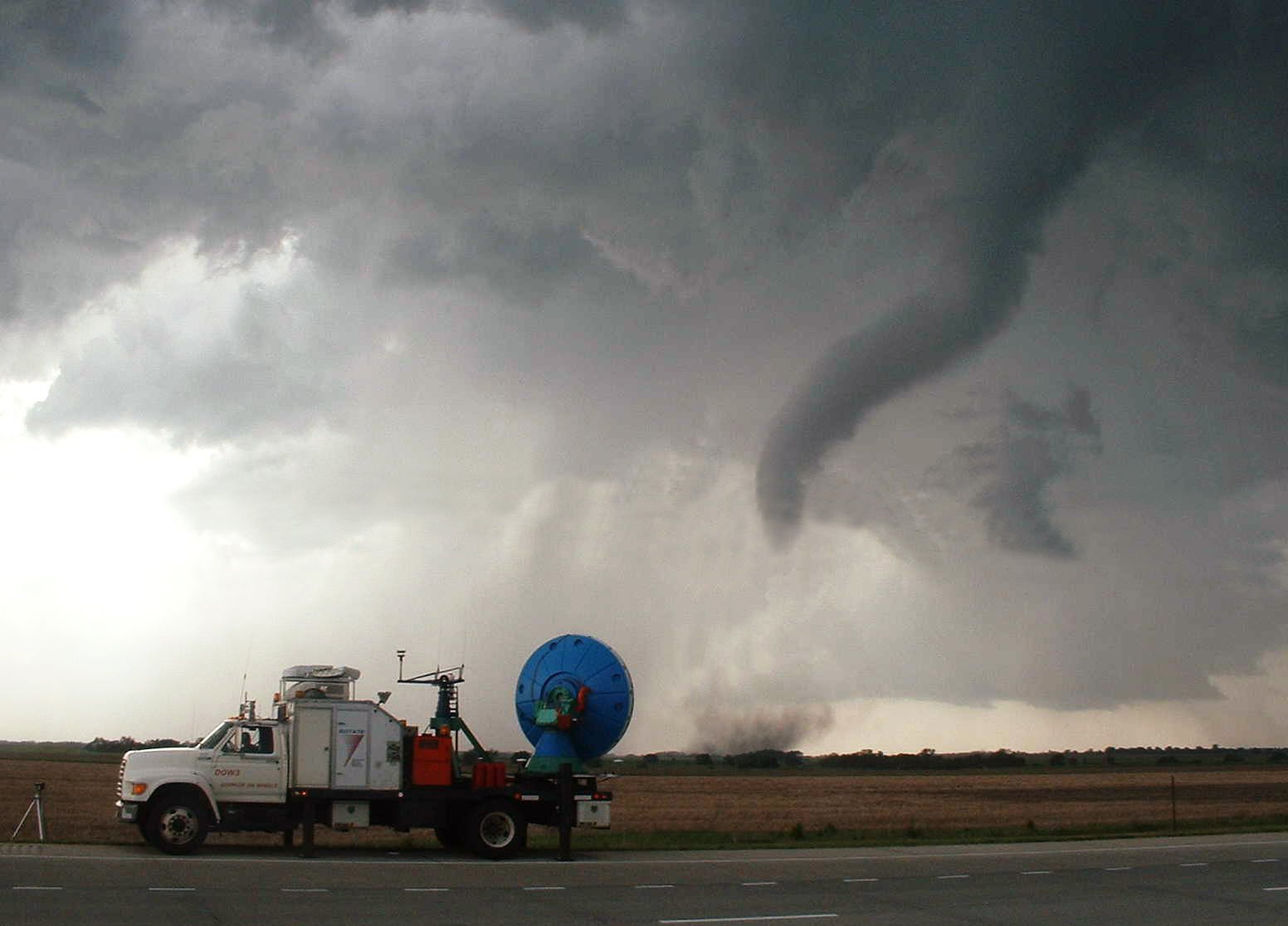
PAR on wheels.
This was a fun read. Reminded me of a radar class I took from George Washington University, when still in the Air Force. We were discussing using side-looking radar imaging systems, but I’ve worked with enough radars to understand how weather radar works. A phased array arrangement would greatly increase both the capacity of detection and the resolution of those particular cells that require more intense scrutiny. There are a couple of other radar tricks I’m surprised the Weather Service isn’t using. Maybe they’re still too classified.